
The skies above modern infrastructure zones now harbor an invisible threat that ecology surveyors must urgently address. As fibre optic drone technology expands beyond conflict zones into commercial and infrastructure applications, abandoned cables create deadly webs that entangle birds, disrupt habitats, and introduce persistent pollutants into ecosystems. In 2026, understanding fibre optic drone cable impacts on avian biodiversity has become critical for ecology surveyors working in infrastructure zones worldwide.
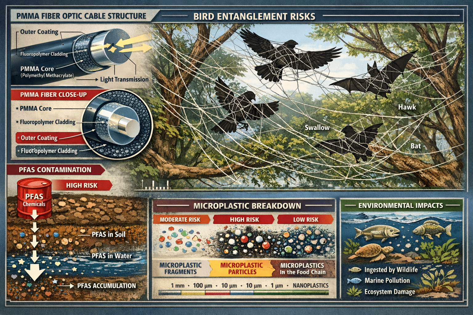
Recent research reveals that these ultra-thin cables, composed primarily of PMMA (polymethyl methacrylate), can persist in the environment for over 600 years[1][3]. With single drones carrying between 5 and 20 kilometers of cable—and some spools reaching up to 41 kilometers—the scale of potential environmental contamination is staggering[1]. For ecology surveyors, this emerging threat demands new assessment protocols and monitoring techniques.
Key Takeaways
- Fibre optic drone cables pose severe entanglement risks to birds and bats, with documented cases already requiring manual rescue operations[1][3]
- PMMA cables persist for 600+ years in the environment and break down into harmful microplastics under harsh conditions[1][3]
- Systematic survey techniques including visual transects, entanglement documentation, and habitat barrier assessments are essential for quantifying impacts
- Chemical contamination from PFAS-containing cladding adds additional long-term risks to soil and water quality in infrastructure zones[1]
- Early detection and monitoring protocols help developers meet biodiversity obligations and implement effective mitigation strategies
Understanding Fibre Optic Drone Cable Threats to Bird Populations
The Scale of Cable Deposition in Infrastructure Zones
Fibre optic drones have rapidly expanded from military applications into commercial infrastructure sectors. Current production data indicates that these drones now comprise approximately 10% of certain manufacturing outputs, with multiple drones operating simultaneously in the same areas[1]. This operational pattern results in substantial quantities of cable deposited across infrastructure development zones, creating cumulative environmental impacts that ecology surveyors must assess.
The cables themselves present unique challenges. Unlike traditional infrastructure materials, fibre optic cables are:
- Extremely lightweight yet incredibly strong 🪢
- Nearly invisible against natural backgrounds
- Highly resistant to degradation due to PMMA composition
- Prone to forming web-like structures across vegetation and clearings[1]
Primary Entanglement Mechanisms
Charlie Russell, a researcher at the University of East Anglia studying conflict impacts on migratory birds, emphasizes that fiber optic cables "will pose a significant risk of entanglement and death to many species, including threatened birds and bats, for years to come"[1]. The entanglement mechanisms include:
Direct Physical Trapping: Birds flying through cable-contaminated areas become wrapped in the thin, strong fibers, restricting wing movement and causing injury or death.
Nesting Material Incorporation: Documented cases show birds attempting to use the durable fibers as nesting material[3], which can lead to chick entanglement or nest structural failures.
Amputation and Asphyxiation: Similar to abandoned fishing gear impacts, fibers can "become wrapped around the necks of animals causing amputation, asphyxiation or starvation"[1].
Chemical and Microplastic Contamination Pathways
Beyond physical entanglement, the cables introduce chemical pollutants into ecosystems. Fiber cables contain fluoropolymer cladding with PFAS (per- and polyfluoroalkyl substances)—highly persistent compounds that contaminate soil and water[1]. These "forever chemicals" represent an additional military and infrastructure PFAS source alongside munitions and firefighting foams.
Under harsh environmental conditions common in infrastructure zones—including:
- Burning and thermal degradation
- Mechanical fragmentation from equipment
- UV radiation exposure
- Freeze-thaw cycles
- Soil disturbance
PMMA fibers break down into microplastics and nanoplastics, with unknown long-term impacts on avian health and ecosystem functioning[3]. Nataliia Hozak, Greenpeace Ukraine director, emphasizes that how fibers behave under sunlight, rain, snow, and seasonal change remains unknown, with answers potentially requiring years or decades to emerge[3].
When conducting biodiversity impact assessments, surveyors must now account for these novel contamination pathways.
Survey Techniques for Ecology Surveyors in 2026 Infrastructure Zones
Pre-Survey Planning and Risk Assessment
Effective assessment of fibre optic drone cable impacts on avian biodiversity begins with comprehensive pre-survey planning. Ecology surveyors should develop site-specific protocols that address:
Desktop Study Components
| Assessment Element | Data Sources | Key Outputs |
|---|---|---|
| Historical drone activity | Infrastructure development records, security reports | Cable deposition likelihood zones |
| Avian species inventory | Local biodiversity databases, migration routes | Priority species vulnerability rankings |
| Habitat sensitivity mapping | GIS vegetation data, breeding site locations | High-risk habitat zones |
| Previous contamination reports | Environmental monitoring records | Baseline contamination levels |
Risk Stratification Framework
Surveyors should categorize infrastructure zones into risk tiers based on:
- High Risk: Active drone operation zones, critical bird habitats, migration corridors
- Moderate Risk: Former operation areas, secondary habitats, occasional bird presence
- Low Risk: Minimal drone activity, low avian biodiversity value, limited vegetation
This stratification enables efficient resource allocation and ensures surveyors focus efforts where fibre optic drone cable impacts on avian biodiversity are most likely to be severe.
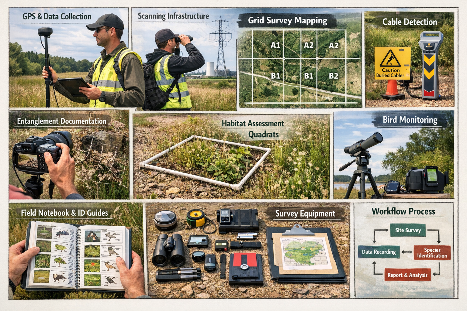
Visual Transect Survey Methodology
Systematic Grid Approach
The foundation of cable impact assessment involves systematic visual surveys using standardized transect methods:
- Establish survey grid: Divide the infrastructure zone into 50m × 50m grid cells
- Random cell selection: Survey minimum 20% of cells, stratified by risk tier
- Transect walking: Walk diagonal transects through each selected cell at 2 km/hour
- Cable detection protocol: Record all visible cable fragments, noting GPS coordinates, length, and vegetation entanglement
Equipment checklist for visual transects:
- High-powered binoculars (10×42 minimum)
- GPS-enabled tablet or smartphone
- Digital camera with macro capability
- Measuring tape (30m minimum)
- Field notebook and species identification guides
- Personal protective equipment (gloves, eye protection)
Cable Identification Techniques
Due to their mixed compositions, fibre optic cables are extremely difficult to identify[1]. Surveyors should look for:
- Thin, translucent or white filaments (typically 0.5-2mm diameter)
- Web-like formations across tree branches and shrubs
- Reflective properties under direct sunlight
- Accumulations near infrastructure equipment or drone landing zones
Entanglement Documentation Protocol
When surveyors encounter bird entanglement incidents, thorough documentation is essential for quantifying impacts:
Immediate Assessment Steps
- Photograph the scene from multiple angles before intervention
- Record species identification (or collect samples for later identification if deceased)
- Document cable configuration including wrap patterns and tension points
- Measure cable length involved in the entanglement
- Assess bird condition (alive, injured, deceased, decomposition stage)
- Note environmental context (vegetation type, height above ground, proximity to nesting sites)
⚠️ Safety Note: Only trained personnel should attempt live bird rescue. Contact licensed wildlife rehabilitators for assistance.
Ukrainian soldiers have already documented and shared videos of birds trapped in fiber webs requiring manual rescue[3], providing valuable case study material for developing standardized rescue protocols.
Habitat Barrier Assessment
Beyond direct entanglement, cables act as physical barriers to avian movement, "effectively becoming fences in the sky, on the ground and in waterways"[1]. This reduces access to high-quality habitat and important resources, diminishing ecosystem functioning.
Barrier Impact Survey Technique
Observation Point Method:
- Establish fixed observation points at 100m intervals along suspected cable barrier zones
- Conduct 30-minute observation periods during peak bird activity (dawn and dusk)
- Record bird flight paths, noting deflections, collisions, or avoidance behaviors
- Map "barrier zones" where bird movement is demonstrably altered
Habitat Connectivity Analysis:
- Use GIS mapping to overlay cable distribution with habitat patches
- Calculate connectivity indices before and after cable contamination
- Identify critical movement corridors that have been compromised
- Assess impacts on breeding success and foraging efficiency
This approach aligns with broader biodiversity net gain assessment requirements by quantifying habitat quality degradation.
Behavioral Adaptation Monitoring
Documented cases show birds using the thin fibers to build nests[3], suggesting wildlife is attempting to utilize the material despite its hazards. Surveyors should monitor these behavioral adaptations through:
Nest Survey Protocol
- Conduct systematic nest searches during breeding season
- Document nesting material composition, noting percentage of synthetic fibers
- Monitor nest success rates comparing fiber-incorporated versus traditional nests
- Assess chick entanglement or mortality associated with fiber use
Long-Term Population Monitoring
Establishing baseline population data enables detection of population-level impacts:
- Annual breeding bird surveys using standardized point count methods
- Mark-recapture studies for resident species
- Migration monitoring at key stopover sites
- Survival analysis comparing contaminated versus reference sites
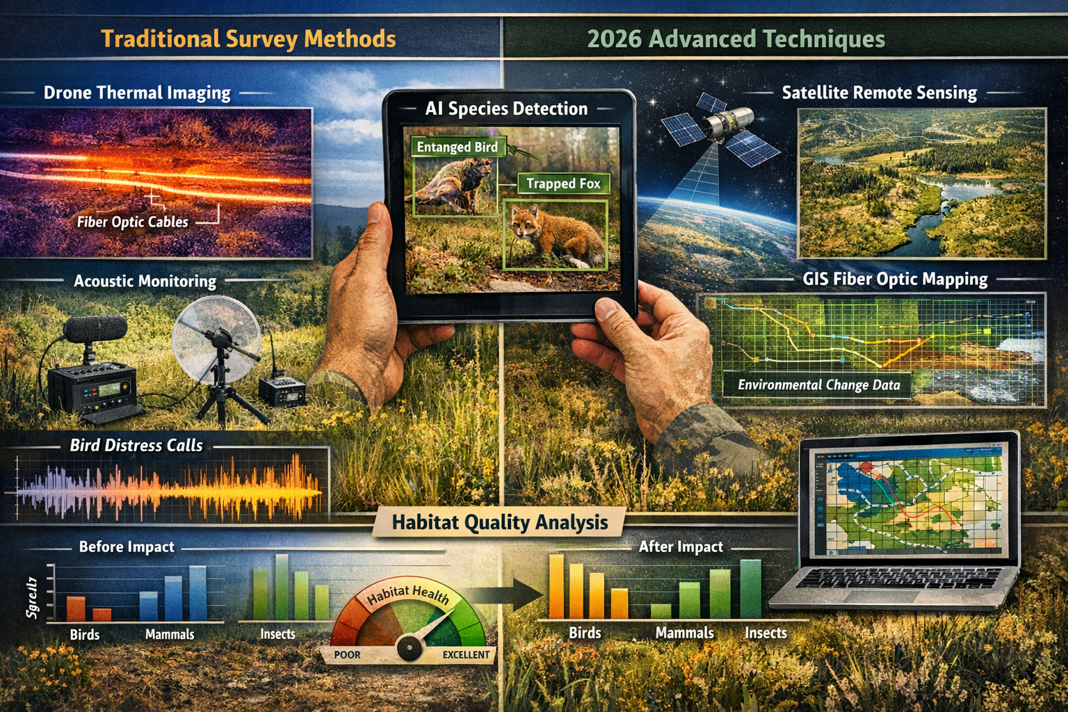
Advanced Detection Technologies for 2026 Survey Applications
Drone-Based Remote Sensing
Ironically, surveyor drones equipped with specialized sensors offer powerful tools for detecting abandoned fibre optic cables:
Thermal Imaging Applications
Fibre optic cables exhibit different thermal properties than natural vegetation. Thermal imaging cameras mounted on survey drones can detect:
- Temperature differentials revealing cable presence beneath vegetation
- Heat retention patterns indicating cable density
- Seasonal thermal signatures aiding detection timing
Multispectral and Hyperspectral Imaging
Advanced imaging systems can identify PMMA spectral signatures that are invisible to the human eye. Key advantages include:
- Rapid area coverage: Survey 100+ hectares per day
- Consistent detection: Reduced observer bias compared to visual surveys
- Data integration: Direct import into GIS systems for spatial analysis
- Repeat monitoring: Establish temporal trends in cable distribution
Acoustic Monitoring for Distress Detection
Automated acoustic recorders deployed throughout infrastructure zones can detect bird distress calls associated with entanglement events:
- Continuous 24/7 monitoring captures incidents during all activity periods
- Machine learning algorithms identify species-specific distress vocalizations
- GPS-enabled recorders pinpoint entanglement hotspots
- Long-term datasets reveal seasonal patterns in incident frequency
AI-Powered Image Recognition
Artificial intelligence applications are revolutionizing how surveyors process field data:
Automated Cable Detection: Train neural networks to identify cable fragments in field photographs, dramatically reducing analysis time.
Species Identification: AI-powered apps provide instant species confirmation from photographs, improving accuracy for non-specialist surveyors.
Entanglement Pattern Analysis: Machine learning algorithms can classify entanglement severity and predict mortality risk based on image analysis.
These technologies complement traditional field methods, enabling more comprehensive assessment of fibre optic drone cable impacts on avian biodiversity in 2026 infrastructure zones.
Mitigation Strategies and Developer Obligations
Regulatory Framework in 2026
As fibre optic drone cable impacts become recognized as a significant environmental threat, regulatory frameworks are evolving. Developers and infrastructure operators must now consider:
Biodiversity Net Gain Requirements
Under current biodiversity net gain legislation, developments must deliver measurable biodiversity improvements. Cable contamination directly undermines these objectives by:
- Reducing habitat quality scores in affected areas
- Increasing mortality risk for protected species
- Introducing persistent pollutants that degrade ecosystem health
- Creating long-term management liabilities
Developers should proactively address cable impacts to avoid biodiversity unit penalties and compliance failures.
Environmental Impact Assessment Integration
Ecology surveyors must ensure fibre optic cable risks are incorporated into:
- Preliminary Ecological Appraisals (PEA): Identify cable contamination risk during initial site assessments
- Ecological Impact Assessments (EcIA): Quantify impacts on valued ecological receptors
- Environmental Management Plans: Specify cable removal and monitoring protocols
- Post-development monitoring: Track long-term population responses to mitigation measures
Practical Mitigation Approaches
Cable Recovery and Removal Programs
Systematic removal offers the most effective mitigation, though challenges exist:
✅ Best Practices:
- Conduct removal during non-breeding seasons to minimize disturbance
- Use trained personnel with appropriate safety equipment
- Employ systematic grid searches to maximize recovery rates
- Document removal quantities and disposal methods
- Monitor sites post-removal to detect residual contamination
⚠️ Challenges:
- Cables are extremely difficult to locate due to their transparency[1]
- Mixed compositions make recycling problematic[1]
- Fragmented cables may be impossible to fully recover
- Removal operations can cause vegetation damage
Habitat Enhancement Compensation
Where complete cable removal is impractical, compensatory habitat creation may offset impacts:
- Establish predator-free breeding sites for affected species
- Create alternative foraging areas with enhanced food resources
- Install artificial nest structures in cable-free zones
- Implement off-site biodiversity net gain delivery in uncontaminated areas
Exclusion and Deterrent Measures
Prevent birds from accessing cable-contaminated zones through:
- Strategic vegetation management to reduce perching opportunities
- Visual deterrents in high-risk entanglement areas
- Temporary exclusion fencing during critical breeding periods
- Habitat modification to redirect bird movement away from cable concentrations
Developer Guidance and Planning Integration
For developers working in infrastructure zones with potential cable contamination, early engagement with ecology surveyors is essential. Our guidance for developers emphasizes proactive risk assessment.
Planning checklist for developers:
- Commission baseline surveys before site acquisition to identify cable contamination
- Budget for remediation including removal, monitoring, and mitigation costs
- Engage specialists early to develop site-specific protocols
- Integrate findings into design to avoid high-contamination zones
- Establish monitoring programs to demonstrate compliance with biodiversity obligations
Understanding how to achieve 10% biodiversity net gain becomes more challenging when cable contamination reduces baseline habitat quality.
Research Gaps and Future Monitoring Priorities
Current Scientific Understanding
Serious scientific study of fiber optic environmental impacts only began approximately one year ago (around February 2025)[3]. Maxim Soroka, environmental safety expert and science director at Dovkol Laboratory, notes that scientists currently rely largely on existing knowledge about plastics and polymers[3].
This limited research base creates significant uncertainties for ecology surveyors:
Unknown Degradation Pathways
How PMMA fibers behave under various environmental conditions remains poorly understood:
- UV degradation rates in different climatic zones
- Freeze-thaw cycle impacts on fiber fragmentation
- Microbial degradation potential in various soil types
- Aquatic degradation pathways in wetland and riparian zones
Toxicological Knowledge Gaps
The impacts of PFAS contamination from cable cladding on avian health require urgent research:
- Bioaccumulation rates in terrestrial and aquatic food webs
- Reproductive impacts on exposed bird populations
- Chronic exposure effects on immune function and survival
- Species-specific sensitivity variations
Ecosystem-Level Impacts
Broader ecosystem consequences remain largely unquantified:
- Cascading effects on predator-prey relationships
- Impacts on ecosystem services (pollination, seed dispersal)
- Long-term soil health degradation from microplastic accumulation
- Synergistic effects with other environmental stressors
Priority Research Directions for 2026-2030
To improve survey effectiveness and mitigation strategies, the scientific community must address:
1. Standardized Detection Protocols: Develop and validate remote sensing techniques for consistent cable detection across diverse habitats.
2. Species Vulnerability Assessments: Rank bird and bat species by entanglement risk based on behavioral ecology, habitat use, and flight patterns.
3. Degradation Timeline Studies: Conduct long-term field experiments tracking PMMA breakdown rates under controlled environmental conditions.
4. Remediation Effectiveness Trials: Compare removal techniques, monitoring their success rates and unintended consequences.
5. Population-Level Impact Studies: Establish long-term monitoring programs tracking demographic responses in contaminated versus reference populations.
Collaborative Monitoring Networks
Ecology surveyors can contribute to scientific understanding through standardized data collection:
- Report all cable encounters to centralized databases
- Document entanglement incidents with detailed photographic evidence
- Collect cable samples for material analysis and degradation studies
- Share survey protocols and lessons learned through professional networks
This collaborative approach accelerates knowledge development and improves survey techniques for assessing fibre optic drone cable impacts on avian biodiversity in 2026 infrastructure zones.
Case Studies: Lessons from Early Assessment Programs
Frontline Zone Monitoring in Eastern Europe
The most extensive experience with fibre optic cable impacts comes from conflict-affected areas where drone usage has been most intensive. Key lessons include:
Detection Challenges: Even in areas with known high cable densities, visual detection rates remain below 40% due to the cables' transparency and tendency to blend with vegetation.
Seasonal Variation: Cable detection is significantly easier during winter months when deciduous vegetation has dropped, suggesting surveyors should time assessments strategically.
Hotspot Patterns: Cable accumulation is highly clustered around former drone operation centers, enabling targeted survey efforts rather than uniform coverage.
Wildlife Adaptation: Some bird species appear to avoid cable-contaminated areas, suggesting behavioral plasticity may reduce impacts for certain taxa while concentrating risks on less adaptable species.
Infrastructure Corridor Assessments
Commercial infrastructure projects incorporating drone technology for surveying or monitoring have begun implementing proactive cable management:
Prevention-Focused Approaches: Some operators now use biodegradable fiber alternatives or implement mandatory cable recovery as part of operational protocols.
Integrated Monitoring: Combining cable surveys with routine biodiversity impact assessments ensures impacts are detected early and addressed within existing regulatory frameworks.
Stakeholder Engagement: Transparent reporting of cable contamination and mitigation efforts builds trust with regulators and demonstrates commitment to benefitting nature alongside development.
Practical Implementation Guide for Surveyors
Developing Site-Specific Survey Protocols
Every infrastructure zone presents unique challenges. Surveyors should adapt general techniques to site-specific conditions:
Site Characterization Factors
Vegetation Structure:
- Dense canopy: Prioritize drone-based remote sensing
- Open grassland: Visual transects highly effective
- Mixed habitats: Combine multiple detection methods
Bird Community Composition:
- High raptor abundance: Focus on entanglement risk assessment
- Migratory stopover site: Time surveys to coincide with peak migration
- Breeding colony present: Intensive nesting material surveys essential
Cable Contamination Likelihood:
- Known drone operations: Comprehensive systematic surveys required
- Suspected contamination: Targeted surveys in high-risk zones
- Low probability: Incorporate cable checks into routine biodiversity monitoring
Data Management and Reporting
Field Data Collection:
- Use standardized data sheets ensuring consistency across survey teams
- Employ GPS-enabled devices for accurate spatial referencing
- Photograph all cable finds and entanglement incidents
- Record environmental conditions affecting detection probability
Data Analysis and Interpretation:
- Calculate cable density metrics (m/hectare) for spatial comparison
- Estimate entanglement rates relative to bird abundance
- Map high-risk zones using GIS spatial analysis
- Compare findings against reference sites or baseline data
Reporting Requirements:
- Provide clear executive summaries for non-technical stakeholders
- Include photographic evidence of key findings
- Offer specific, actionable mitigation recommendations
- Estimate costs for remediation and ongoing monitoring
Professional Development and Training
As fibre optic drone cable impacts represent an emerging threat, surveyors should pursue ongoing professional development:
- Attend specialized training on cable detection techniques
- Participate in collaborative research programs
- Stay current with evolving regulatory requirements
- Share experiences through professional networks and publications
Conclusion
Fibre optic drone cable impacts on avian biodiversity represent a significant and growing threat in 2026 infrastructure zones. As these cables persist for centuries, entangle birds and bats, and introduce harmful chemicals into ecosystems, ecology surveyors must adapt their assessment techniques to detect and quantify these impacts effectively.
Key actions for ecology surveyors:
✅ Integrate cable assessments into all infrastructure zone biodiversity surveys, using systematic visual transects, remote sensing technologies, and behavioral monitoring protocols.
✅ Document thoroughly all cable encounters and entanglement incidents to build the scientific evidence base and inform mitigation strategies.
✅ Engage developers early to ensure cable contamination is addressed during project planning, preventing costly remediation and regulatory compliance failures.
✅ Advocate for prevention by recommending biodegradable alternatives, mandatory cable recovery programs, and operational best practices that minimize environmental contamination.
✅ Contribute to research by sharing data, participating in collaborative monitoring networks, and supporting studies that address critical knowledge gaps.
The challenge is substantial, but proactive assessment and mitigation can prevent long-term damage to avian populations. By implementing the survey techniques outlined in this guide, ecology surveyors play a crucial role in protecting biodiversity while enabling responsible infrastructure development.
For developers and surveyors seeking support with biodiversity assessments in infrastructure zones, contact our team to discuss site-specific survey protocols and mitigation strategies that address fibre optic cable impacts alongside broader biodiversity obligations.
The next decade will determine whether we successfully manage this emerging threat or allow it to become another persistent environmental legacy. Through rigorous survey techniques, collaborative research, and proactive mitigation, ecology surveyors can ensure that infrastructure development in 2026 and beyond supports rather than undermines avian biodiversity.
References
[1] Plastic Pollution From Fibre Optic Drones May Threaten Wildlife For Years – https://ceobs.org/plastic-pollution-from-fibre-optic-drones-may-threaten-wildlife-for-years/
[2] Abandoned Drone Fiber Optics Harming Wildlife – https://wildconflict.com/abandoned-drone-fiber-optics-harming-wildlife/
[3] Fiber Optic Drone Ukraine Battlefields – https://dronexl.co/2026/02/10/fiber-optic-drone-ukraine-battlefields/
[4] Fiber Optic Drone Pollution In Ukraine Environmental Risks And Scientific Uncertainty – https://uwecworkgroup.info/fiber-optic-drone-pollution-in-ukraine-environmental-risks-and-scientific-uncertainty/
[5] Fiber Optic Web How The Use Of Drones On The Frontlines Impacts The Environment – https://uwecworkgroup.info/fiber-optic-web-how-the-use-of-drones-on-the-frontlines-impacts-the-environment/
