
The ocean floor holds treasures worth trillions—but at what cost to life we've barely begun to understand? As mining companies prepare to extract polymetallic nodules from depths of 4,000 meters beneath the ocean surface, surveyors face an unprecedented challenge: documenting ecosystems that may disappear forever before science has fully cataloged them. Deep Sea Mining Biodiversity Surveys: Risk Assessment Protocols for Surveyors in 2026 Exploration Zones represent the critical frontline between industrial progress and irreversible environmental loss.
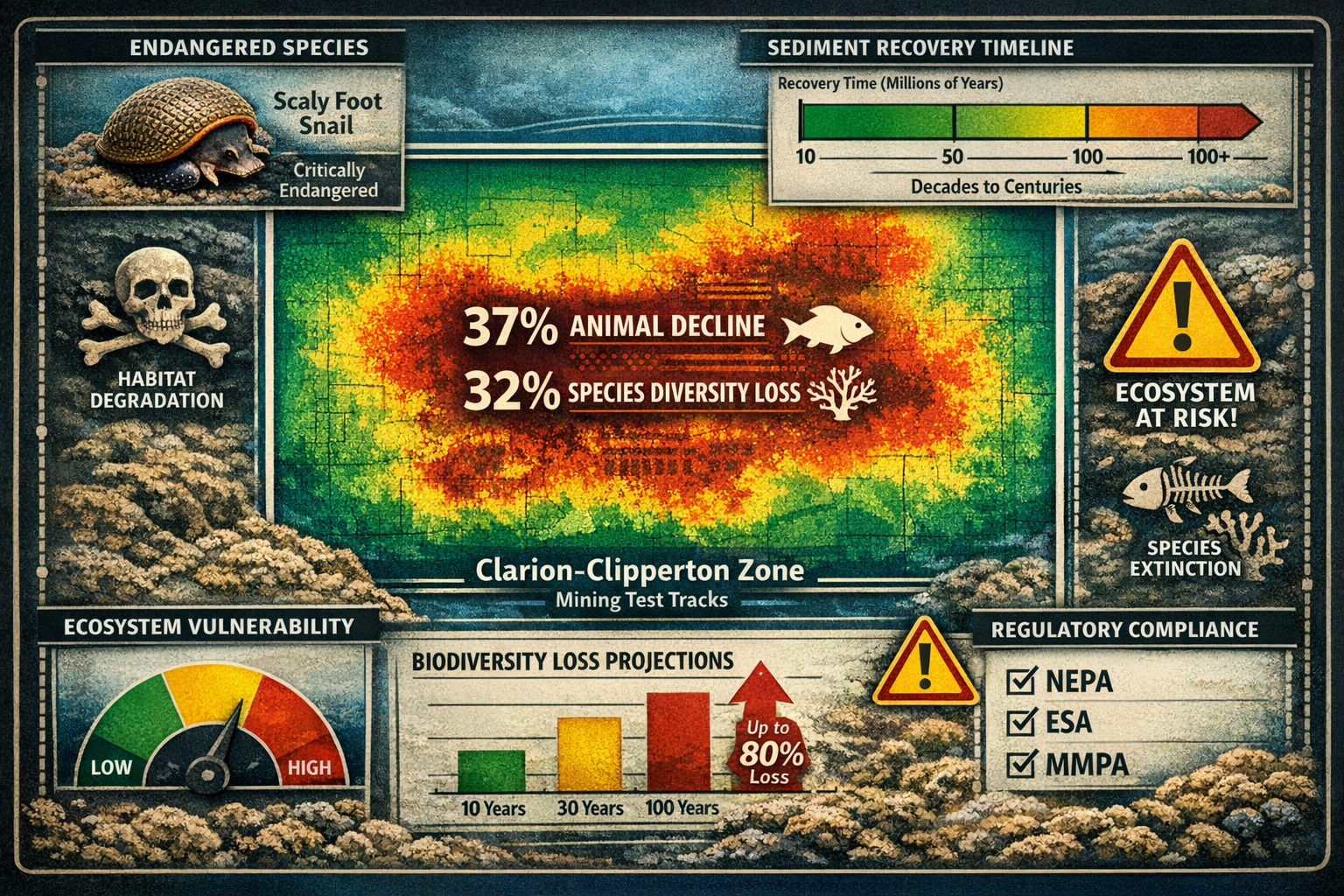
In 2026, the race to the seabed has accelerated dramatically. A groundbreaking study published in Nature Ecology & Evolution documented nearly 800 species across the Clarion-Clipperton Zone in the Pacific Ocean, with many previously unknown to science.[1] Yet test mining operations in the same region caused a 37% decline in animal numbers and a 32% reduction in species diversity along equipment paths.[1] These findings underscore the urgent need for robust survey protocols that can accurately assess risks before commercial operations begin.
Key Takeaways
- 🔬 Baseline surveys must document ecosystems at 4,000+ meter depths where sediment recovery occurs at just one thousandth of a millimeter per year, making damage effectively permanent
- ⚖️ New NOAA regulations (January 2026) require comprehensive environmental impact statements, monitoring plans, and mitigation strategies for all deep-sea mining applications[4]
- 🌊 ROV-based survey methods combining HD imaging, sediment sampling, and species identification are essential for quantifying biodiversity before mining operations
- ⚠️ Biodiversity loss is expected to be irreversible for species endemic to deep-sea environments, with polymetallic nodule removal causing permanent habitat destruction[2]
- 🎯 Marine biodiversity net gain offsets must account for million-year recovery timelines and the impossibility of replacing unique deep-sea ecosystems
Understanding Deep Sea Mining Biodiversity Surveys in 2026
The Scale of the Challenge
Deep-sea mining targets three primary resource types: polymetallic nodules, seafloor massive sulfides, and cobalt-rich ferromanganese crusts. These deposits contain critical minerals including cobalt, nickel, copper, and rare earth elements essential for batteries, electronics, and renewable energy technologies.
The Clarion-Clipperton Zone (CCZ), located between Mexico and Hawaii, represents the world's most extensively studied deep-sea mining area. A comprehensive five-year study involving 160 days at sea followed International Seabed Authority guidelines for baseline studies and environmental impact assessments.[1] This research established the gold standard for what Deep Sea Mining Biodiversity Surveys: Risk Assessment Protocols for Surveyors in 2026 Exploration Zones must achieve.
Regulatory Framework Changes
On January 21, 2026, NOAA published a final rule substantially restructuring American deep-sea mining regulations.[4] The updated framework consolidates and expedites permit and license application processes while maintaining rigorous environmental protections. Key requirements include:
- Environmental Impact Statements (EIS) under the National Environmental Policy Act (NEPA)
- Comprehensive monitoring plans with data acquisition standards
- Mitigation strategies to avoid significant adverse effects
- Consultations under the Endangered Species Act, Marine Mammal Protection Act, and Coastal Zone Management Act[4]
NOAA is separately updating its Deep Seabed Mining Final Technical Guidance Document with specific data acquisition standards for environmental monitoring, with a draft version expected for public review in 2026.[4]
Similar to terrestrial development projects requiring biodiversity impact assessments, deep-sea mining operations must demonstrate thorough understanding of baseline conditions before disturbance occurs.
Field and ROV-Based Survey Methods for Baseline Ecosystem Quantification
Essential Survey Technologies
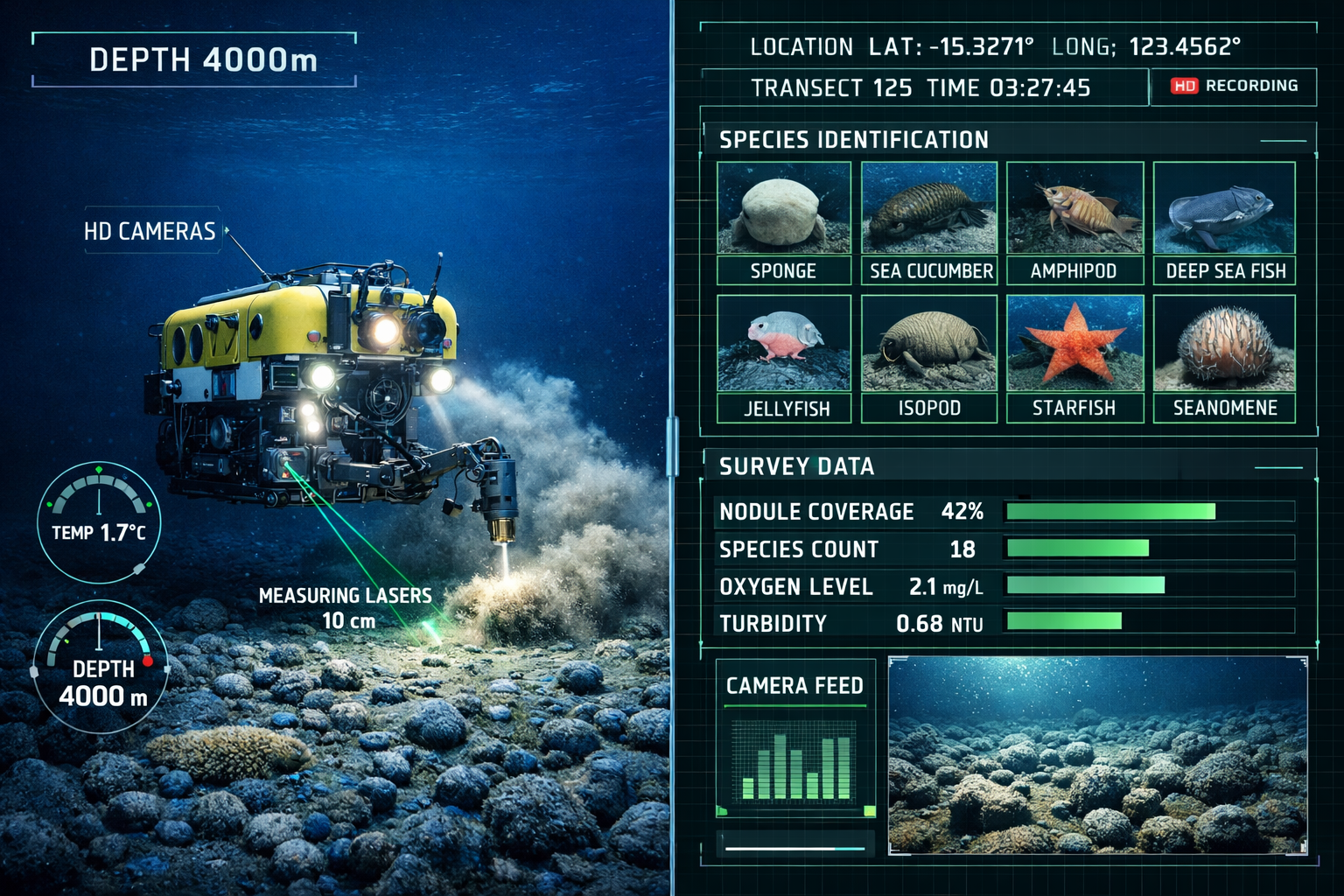
Remotely Operated Vehicles (ROVs) equipped with specialized instruments form the backbone of deep-sea biodiversity surveys. At depths of 4,000 meters, human divers cannot operate, making ROVs the primary tool for direct observation and sampling.
Core ROV Equipment Requirements:
| Equipment Type | Purpose | Key Specifications |
|---|---|---|
| HD Camera Systems | Visual documentation | 4K+ resolution, low-light capability |
| Manipulator Arms | Sample collection | Precision gripping, sediment cores |
| Sonar Mapping | Terrain analysis | Multibeam, side-scan capabilities |
| Environmental Sensors | Water quality monitoring | Temperature, salinity, oxygen, pH |
| Specimen Collection | Physical sampling | Suction samplers, collection boxes |
Systematic Survey Protocols
Effective Deep Sea Mining Biodiversity Surveys: Risk Assessment Protocols for Surveyors in 2026 Exploration Zones follow standardized methodologies:
1. Transect-Based Visual Surveys
Surveyors establish grid patterns across proposed mining zones, conducting systematic ROV transects to:
- Document species presence and abundance
- Map habitat types and nodule distributions
- Identify rare or endemic species
- Record behavioral observations
The recent CCZ study identified a new solitaire coral species during such systematic surveys,[1] highlighting how baseline documentation continues revealing unknown biodiversity.
2. Sediment Core Analysis
Deep-sea sediment grows at an extraordinarily slow rate—just one thousandth of a millimeter per year.[1] Core samples provide:
- Historical ecological records spanning thousands of years
- Microbial community composition
- Geochemical baseline data
- Recovery rate indicators
3. Environmental DNA (eDNA) Sampling
Water column sampling for eDNA enables detection of species that may not appear during visual surveys, providing comprehensive biodiversity inventories without extensive physical collection.
4. Long-Term Monitoring Stations
Autonomous landers and moored sensors collect continuous data on:
- Sediment plume behavior
- Current patterns affecting dispersal
- Seasonal variations in biological activity
- Recovery rates post-disturbance
Quantifying Baseline Metrics
Surveyors must establish quantifiable baseline metrics before any mining activity. Critical measurements include:
- Species richness (total number of species)
- Species abundance (population sizes)
- Community composition (relative proportions)
- Habitat extent (area coverage by type)
- Functional diversity (ecological roles represented)
These metrics enable comparison with biodiversity net gain assessments used in terrestrial contexts, though marine applications face unique challenges.
Risk Assessment Protocols: Horizon Scan Analysis for Deep-Sea Mining
Identifying Primary Risk Categories
Deep Sea Mining Biodiversity Surveys: Risk Assessment Protocols for Surveyors in 2026 Exploration Zones must address multiple risk categories through systematic horizon scanning:
🔴 Direct Physical Impacts
- Nodule removal: Permanent loss of substrate habitat
- Sediment disturbance: Plume generation affecting wide areas
- Equipment damage: Crushing of organisms and habitat structures
- Noise pollution: Disruption of acoustic communication
Test mining data shows 37% decline in animal numbers along mining paths,[1] representing severe direct impact.
🟠 Ecosystem Function Disruption
- Food web alterations: Removal of primary habitat formers
- Nutrient cycling changes: Disruption of sediment-water interface processes
- Connectivity loss: Fragmentation of continuous habitats
- Recruitment failure: Inability of larvae to settle on disturbed areas
🟡 Cumulative and Cascading Effects
- Multi-site impacts: Combined effects across multiple mining operations
- Temporal accumulation: Long-term degradation exceeding recovery capacity
- Trophic cascades: Indirect effects propagating through food webs
- Genetic isolation: Population fragmentation reducing genetic diversity
Species-Specific Vulnerability Assessment
The scaly foot snail became the first species endemic to deep-sea hydrothermal vents to enter the IUCN Red List of Threatened Species in 2019, directly due to threats from future deep-sea mining.[2] This precedent establishes the framework for assessing species-level risks.
High-Risk Species Characteristics:
- Endemic to mining zones (no alternative habitats)
- Slow reproduction rates
- Specialized habitat requirements
- Limited dispersal capabilities
- Small population sizes
Irreversibility Assessment
Scientists caution that biodiversity loss from deep-sea mining is expected to be irreversible.[2] Removing polymetallic nodules means all biodiversity directly dependent on the minerals will be lost for millions of years at mined locations, as nodules require millions of years to re-form.[3]
This irreversibility fundamentally changes risk assessment calculations. Unlike terrestrial mining where restoration may occur over decades, deep-sea environments operate on geological timescales.
"Species endemic to deep-sea hydrothermal vents are unable to recolonize affected areas once mining has occurred, representing permanent local extinction." [2]
Regulatory Compliance Risk Matrix
Surveyors must ensure compliance across multiple regulatory frameworks:
Federal Requirements (U.S. Operations):
- ✅ National Environmental Policy Act (NEPA) compliance
- ✅ Endangered Species Act consultations
- ✅ Marine Mammal Protection Act adherence
- ✅ Coastal Zone Management Act coordination[4]
International Requirements:
- ✅ International Seabed Authority (ISA) guidelines
- ✅ Convention on Biological Diversity protocols
- ✅ Regional fisheries management considerations
- ✅ High seas conservation area designations
Understanding these requirements parallels the comprehensive approach needed for achieving biodiversity net gain without risk in terrestrial projects.
Biodiversity Net Gain Offsets for Marine High-Risk Areas
The Marine BNG Challenge
Applying Biodiversity Net Gain (BNG) principles to deep-sea mining presents unprecedented challenges. While terrestrial BNG frameworks have matured significantly—as detailed in guidance on how to conduct biodiversity impact assessments—marine applications face fundamental obstacles:
Key Differences from Terrestrial BNG:
| Factor | Terrestrial BNG | Deep-Sea Marine BNG |
|---|---|---|
| Recovery Timeline | Years to decades | Millions of years |
| Habitat Recreation | Feasible with restoration | Impossible for nodule fields |
| Species Replacement | Possible through translocation | Endemic species cannot relocate |
| Monitoring Accessibility | Relatively easy | Extremely difficult and costly |
| Baseline Knowledge | Well-documented | Many species undiscovered |
Calculating Marine Biodiversity Units
Traditional BNG calculations use habitat distinctiveness, condition, and area to determine biodiversity units. For deep-sea environments, modified metrics must account for:
Enhanced Weighting Factors:
- Endemism multiplier: Species found nowhere else receive higher values
- Recovery impossibility: Irreplaceable habitats receive maximum protection status
- Functional uniqueness: Ecosystems providing irreplaceable services
- Scientific value: Undescribed species and evolutionary significance
Offset Strategy Options
Given the impossibility of recreating deep-sea nodule ecosystems, offset strategies must focus on avoidance and protection rather than compensation:
1️⃣ Spatial Avoidance
Designating no-mining zones within exploration areas to:
- Preserve representative habitat samples
- Maintain connectivity corridors
- Protect biodiversity hotspots
- Enable scientific reference sites
2️⃣ Marine Protected Area Expansion
Investing in expanded protection of comparable deep-sea environments:
- Establishing new MPAs in similar ecosystems
- Enhancing enforcement in existing protected areas
- Supporting long-term monitoring programs
- Funding deep-sea conservation research
3️⃣ Threat Reduction Elsewhere
Reducing existing pressures on deep-sea ecosystems:
- Controlling bottom trawling in vulnerable areas
- Reducing plastic pollution reaching deep waters
- Mitigating climate change impacts on deep-sea systems
- Supporting sustainable fisheries management
4️⃣ Research and Monitoring Investment
Contributing to scientific understanding:
- Funding baseline surveys in unexplored regions
- Supporting taxonomic research on deep-sea species
- Developing improved survey technologies
- Training next-generation deep-sea scientists
Case Study: Clarion-Clipperton Zone Conservation Framework
The ISA has designated nine Areas of Particular Environmental Interest (APEIs) within the CCZ, covering approximately 1.44 million square kilometers. These protected areas represent an early attempt at marine spatial planning for BNG-like outcomes.
However, the five-year biodiversity study revealed that different APEIs host different species communities,[1] meaning protection in one area doesn't necessarily compensate for impacts in another—a critical finding for offset planning.
Implementing the Mitigation Hierarchy
Deep Sea Mining Biodiversity Surveys: Risk Assessment Protocols for Surveyors in 2026 Exploration Zones must apply the mitigation hierarchy rigorously:
Step 1: Avoidance 🚫
- Identify and exclude biodiversity hotspots
- Avoid spawning or nursery areas
- Prevent impacts on rare species locations
- Minimize footprint through technology optimization
Step 2: Minimization ⚠️
- Reduce sediment plume generation
- Limit operational timeframes
- Use precision extraction techniques
- Implement real-time monitoring with adaptive management
Step 3: Restoration 🔄
- Acknowledge restoration impossibility for nodule habitats
- Focus on secondary impact restoration (sediment plumes)
- Support natural recovery through protected reference areas
Step 4: Offset ⚖️
- Apply enhanced protection to comparable ecosystems
- Invest in threat reduction for deep-sea environments
- Support scientific research advancing conservation
This hierarchy mirrors approaches used in planning biodiversity net gain projects, adapted for marine contexts.
Implementation Framework for Surveyors
Pre-Survey Planning Phase
Regulatory Coordination 📋
- Engage with NOAA and ISA early in planning
- Identify all applicable consultation requirements
- Establish data sharing protocols
- Define monitoring duration and intensity
Technical Preparation 🔧
- Assemble qualified multidisciplinary team
- Secure appropriate ROV and survey equipment
- Develop species identification protocols
- Establish data management systems
Stakeholder Engagement 🤝
- Consult with scientific community
- Engage conservation organizations
- Coordinate with other operators in region
- Communicate with affected coastal nations
Survey Execution Phase
Quality Control Measures ✅
- Implement standardized survey protocols
- Conduct regular equipment calibration
- Maintain detailed metadata records
- Perform real-time data validation
Adaptive Management 🔄
- Monitor survey effectiveness continuously
- Adjust methods based on initial findings
- Respond to unexpected discoveries
- Document protocol modifications
Post-Survey Analysis and Reporting
Data Analysis Requirements 📊
- Statistical analysis of species distributions
- Habitat mapping and classification
- Risk modeling for proposed operations
- Uncertainty quantification
Reporting Standards 📝
- Comprehensive species inventories
- Baseline condition documentation
- Impact predictions with confidence intervals
- Mitigation and offset recommendations
Reports must meet standards comparable to biodiversity net gain reports required for terrestrial development.
Emerging Technologies and Future Directions
Autonomous Survey Platforms
Autonomous Underwater Vehicles (AUVs) are revolutionizing deep-sea surveys by:
- Conducting extended missions without surface support
- Following pre-programmed survey patterns with precision
- Collecting continuous data over large areas
- Reducing operational costs
Artificial Intelligence Applications
Machine learning algorithms are enhancing survey efficiency through:
- Automated species identification from imagery
- Pattern recognition for habitat classification
- Anomaly detection for rare species
- Predictive modeling of biodiversity distributions
Real-Time Environmental Monitoring
Sensor networks deployed across mining zones enable:
- Continuous sediment plume tracking
- Immediate detection of unexpected impacts
- Adaptive management trigger systems
- Long-term baseline trend analysis
Genetic and Molecular Tools
Advanced molecular techniques provide deeper insights:
- Environmental DNA metabarcoding for comprehensive inventories
- Population genetics revealing connectivity patterns
- Functional genomics understanding adaptation mechanisms
- Microbiome analysis revealing ecosystem health
Conclusion
Deep Sea Mining Biodiversity Surveys: Risk Assessment Protocols for Surveyors in 2026 Exploration Zones stand at the intersection of technological advancement and environmental stewardship. The evidence is clear: deep-sea ecosystems face irreversible biodiversity loss if mining proceeds without rigorous assessment and protection measures. The recent documentation of nearly 800 species in the Clarion-Clipperton Zone—many unknown to science—alongside the devastating 37% decline in animal numbers from test mining operations, demonstrates both the richness of these ecosystems and their vulnerability.[1]
Key Action Steps for Surveyors
Immediate Actions 🎯
- Master updated NOAA regulations published in January 2026 and ensure full compliance with environmental impact statement requirements[4]
- Invest in ROV-based survey capabilities including HD imaging, precision sampling, and environmental sensor arrays
- Establish baseline documentation protocols that account for million-year recovery timelines and irreversibility
- Develop species-specific risk assessments identifying endemic and vulnerable populations
Strategic Priorities 🔍
- Apply the mitigation hierarchy rigorously, recognizing that avoidance is the only truly effective strategy for irreplaceable deep-sea habitats
- Design marine biodiversity net gain frameworks that acknowledge restoration impossibility and prioritize spatial protection
- Implement adaptive management systems with real-time monitoring and response capabilities
- Contribute to scientific knowledge through comprehensive data sharing and collaboration
Long-Term Commitments 🌊
- Support expanded marine protected areas as the primary offset mechanism for unavoidable impacts
- Invest in emerging survey technologies including autonomous platforms and AI-enhanced analysis
- Participate in international coordination through ISA processes and scientific working groups
- Maintain monitoring programs extending decades beyond operational phases
The path forward requires acknowledging uncomfortable truths: some ecosystems cannot be restored, some species losses cannot be offset, and some decisions are irreversible. Surveyors conducting Deep Sea Mining Biodiversity Surveys: Risk Assessment Protocols for Surveyors in 2026 Exploration Zones bear extraordinary responsibility—their work will determine whether future generations inherit ocean floors rich with undiscovered life or barren landscapes stripped of biodiversity that took millions of years to evolve.
Just as terrestrial development has evolved to incorporate biodiversity net gain principles, the deep-sea mining industry must embrace even more stringent standards. The stakes are higher, the timelines longer, and the consequences more permanent. Excellence in survey protocols, risk assessment, and offset planning is not merely regulatory compliance—it is our generation's test of whether industrial progress and environmental preservation can coexist in Earth's final frontier.
References
[1] sciencedaily – https://www.sciencedaily.com/releases/2026/02/260201231230.htm
[2] Deep Sea Mining And The Role Of Geneva – https://www.genevaenvironmentnetwork.org/resources/updates/deep-sea-mining-and-the-role-of-geneva/
[3] Trump Administration To Speed Up Permitting For Deep Sea Mining Even Beyond U S Boundaries – https://eos.org/research-and-developments/trump-administration-to-speed-up-permitting-for-deep-sea-mining-even-beyond-u-s-boundaries
[4] Race Seabed Noaa Digs Deeper Combined Permitting Mineral Exploration And Recovery – https://perkinscoie.com/insights/blog/race-seabed-noaa-digs-deeper-combined-permitting-mineral-exploration-and-recovery
