
Fewer than half of BNG submissions rejected by local planning authorities in the past two years were turned away because of calculation errors. The far more common reason was a flawed baseline — surveys that missed habitat parcels, misclassified condition, or were conducted at the wrong time of year. For ecologists and developers navigating mandatory Biodiversity Net Gain requirements, designing biodiversity baseline surveys for BNG is not a box-ticking exercise. It is the technical foundation on which every unit calculation, every mitigation hierarchy decision, and every planning negotiation rests.
This guide walks through the full process of building a defensible baseline survey plan: from choosing the right methods for each habitat type, to allocating effort intelligently across a site, to recognising and avoiding the pitfalls that cause BNG plans to fail at the planning stage. For a broader grounding in what BNG requires before diving into survey design, the biodiversity net gain explained overview is a useful starting point.
Key Takeaways
- Baseline data must map directly to the statutory biodiversity metric (BNG 4.0) habitat classifications, or it cannot be used in calculations without costly re-survey.
- All habitat parcels within the red line boundary must be recorded — not just those directly affected by development.
- A tiered survey approach, using desk-based mapping first, concentrates expensive field effort where it matters most.
- Full-season baselines spread across March to September are now best practice for sites with grassland, wetland, or botanical interest.
- Strategic significance scoring requires active integration with Local Nature Recovery Strategies and must be explicitly justified in the baseline report.
Why the Baseline Is the Most Critical Stage in BNG
The statutory biodiversity metric (BNG 4.0) is unambiguous: every habitat parcel on a site must be recorded with its area or length, habitat type aligned to the metric's own habitat list, condition score, and strategic significance. [2] This dataset is not supplementary evidence — it is the direct input to every BNG calculation. If the baseline is wrong, every number downstream is wrong.
Understanding what is in a biodiversity net gain assessment helps clarify how tightly the baseline feeds into the overall BNG report. The metric requires that all features within the red line boundary are included, not only those that will be physically disturbed. [2] A hedgerow retained at the site edge still needs to be surveyed, typed, measured, and condition-assessed. Omitting it is not a conservative approach — it is a methodological error that can invalidate a submission.
The practical implication is that survey scope must be defined by the red line, not by the construction footprint. This distinction alone changes how ecologists plan their field programmes.

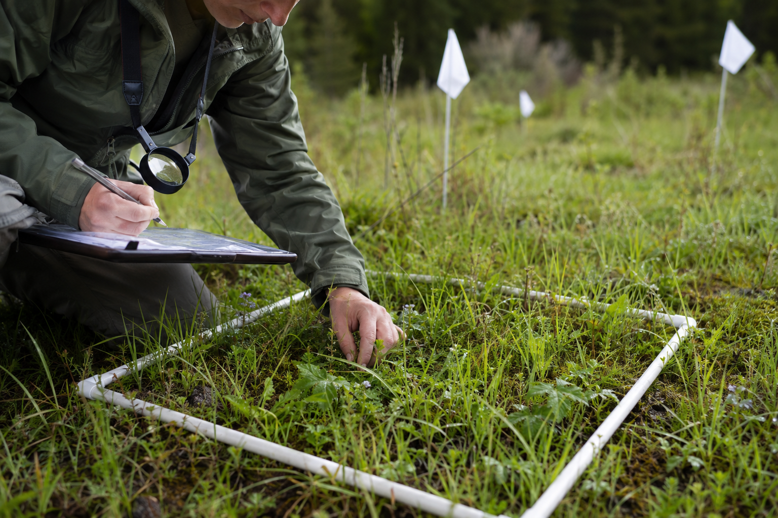
Building the Survey Framework: Desk Study, GIS Mapping, and Tiered Effort Allocation
Designing biodiversity baseline surveys for BNG effectively begins before anyone sets foot on site. A structured desk-based phase reduces wasted field time and ensures effort is concentrated where it generates the most metric value.
Starting with GIS-Based Habitat Mapping
The recommended starting point is a GIS-based habitat mapping exercise using publicly available data layers. Natural England's Living England Habitat Map, UKCEH Land Cover Maps, OS MasterMap, and Defra's Magic Map application all provide spatial context for identifying which parts of a site are likely to hold high-distinctiveness or high-condition habitats. [1]
This pre-survey mapping allows the survey team to divide the site into provisional habitat parcels before fieldwork begins. Parcels that are confidently low-distinctiveness — sealed hardstanding, amenity mown grass, built structures — can be handled efficiently in the field with a rapid walkover and basic measurement. Parcels flagged as potentially high-distinctiveness — semi-improved grassland, hedgerows, woodland, ponds, ditches — are assigned intensive survey effort from the outset. [1]
The result is a tiered effort allocation model:
| Tier | Habitat Type | Desk-Based Confidence | Field Method |
|---|---|---|---|
| 1 | Hardstanding, bare ground, amenity grass | High | Rapid walkover, area measurement |
| 2 | Improved grassland, scrub, young plantation | Medium | Standard walkover, basic condition check |
| 3 | Semi-improved grassland, hedgerows, wetland, woodland | Low | Full botanical survey, multi-visit, condition scoring |
This model is not about cutting corners on low-value areas. It is about directing the finite hours of skilled ecologist time toward the parcels that will drive — or limit — the unit total.
Integrating Historical Data and Addressing Gaps
Incomplete historical data is one of the most common challenges in baseline design. Sites with no previous ecological survey, or with surveys conducted under older methodologies, require careful handling.
Where historical Phase 1 habitat surveys exist but predate BNG 4.0 habitat classifications, they can inform desk-based mapping but cannot substitute for field verification. The metric's habitat list does not map one-to-one with older NVC or Phase 1 categories, and condition criteria are specific to the metric's own condition assessment modules. [2]
Where no historical data exists, the desk-based phase becomes even more important. Cross-referencing aerial photography time series (available through Bing Maps historical imagery or EDINA Digimap) can reveal whether a grassland parcel has been agriculturally improved in recent decades — information that directly informs whether a full botanical survey is warranted.
Method Selection by Habitat Type: Matching Survey Approach to Metric Requirements
The central challenge in designing biodiversity baseline surveys for BNG is that the metric's condition assessments are habitat-specific. Each habitat type has its own condition module with its own indicator species, structural attributes, and measurement protocols. Selecting the wrong survey method — or the right method at the wrong time of year — produces data that cannot be used.
Grasslands
Grasslands are the habitat type most frequently misclassified in BNG baselines, and the consequences are significant. The difference between improved grassland (low distinctiveness, low unit value) and semi-improved or species-rich grassland (medium to high distinctiveness, substantially higher unit value) is determined by botanical composition. That composition is only reliably assessable during the growing season.
A single-visit survey in July or August will miss early-flowering indicator species such as cowslip (Primula veris), early marsh orchid (Dactylorhiza incarnata), and adder's-tongue fern (Ophioglossum vulgatum). Their absence from a survey record does not mean they are absent from the site. [3] Misclassifying a species-rich neutral grassland as improved grassland can cost a development significant baseline units, artificially inflating the uplift required to reach the mandatory 10% net gain.
Best practice for grassland baseline surveys:
- Conduct a minimum of two visits: one in late April to May, one in June to July
- Use the National Vegetation Classification (NVC) DOMIN scale for species frequency recording within representative quadrats
- Record all vascular plant species, bryophytes, and relevant structural attributes (sward height, bare ground percentage, rush or sedge cover) as required by the relevant metric condition module
- Photograph each parcel with a dated, geo-referenced image
Hedgerows
Hedgerows are linear features measured in metres rather than hectares in the metric, but their condition scores are highly sensitive to survey timing and method. Woody species composition — the primary driver of condition scoring — is most reliably recorded when leaves are present (May to September). Structural attributes such as basal gap frequency and tree standard presence can be assessed year-round, but combining both in a single visit is most efficient in early summer.
The Hedgerow Survey Handbook methodology remains the standard field approach, and its outputs map reasonably well to the metric's hedgerow condition module. Surveyors should record species composition, structure, connectivity, and associated boundary features for each discrete hedgerow unit.
Waterbodies and Wetlands
Ponds, ditches, and wetland habitats carry high distinctiveness in the metric and are subject to some of the most time-sensitive survey windows. Aquatic macrophyte surveys are most productive between May and August. Aquatic invertebrate sampling (relevant to ditch condition assessments) has optimal windows that vary by method.
For sites with waterbodies, early engagement with the survey programme timeline is essential. Missing the aquatic survey window by even a few weeks can force a deferral to the following season, with significant programme implications. For developers managing BNG alongside project timelines, the 8 biodiversity net gain points on planning your project resource provides practical sequencing guidance.
Woodland
Woodland condition in the metric is assessed through a combination of structural attributes (canopy cover, shrub layer presence, deadwood) and ground flora composition. Ground flora is strongly seasonal: the spring ephemeral layer in broadleaved woodland — including bluebell (Hyacinthoides non-scripta), wood anemone (Anemone nemorosa), and early purple orchid (Orchis mascula) — is effectively invisible by July. [3]
Front-loading woodland survey effort into March and April, before canopy closure, is now recognised as best practice for capturing the full indicator species assemblage that informs condition scoring. [3] A follow-up visit in June confirms canopy structure and shrub layer development.
Full-Season Baselines and Seasonal Effort Planning
The concept of "full-season baselines" has moved from practitioner preference to near-standard expectation in BNG submissions. Spreading survey effort from early spring through late summer is now the recommended approach for any site where grassland, wetland, or botanical interest could drive unit calculations. [3]
"Relying on single-visit summer surveys has led to missed indicator species and misclassification of improved versus semi-improved grassland — a pattern that has repeatedly undermined BNG submissions at the planning stage." [3]
A practical full-season survey calendar for a mixed-habitat site might look like this:
March to April: Woodland ground flora, hedgerow early-season check, pond dipping (amphibian breeding season), overwintering bird surveys if relevant.
May to June: Primary grassland botanical surveys, hedgerow woody species composition, aquatic macrophyte surveys, wetland vegetation mapping.
July to August: Secondary grassland visit, ditch invertebrate sampling, scrub and tall herb condition checks, final habitat parcel boundary confirmation.
September: Final condition verification for late-season indicators, photography update, habitat parcel area measurement confirmation.
This schedule requires active project management. Survey windows cannot be recovered once missed, and the cost of a deferred baseline — in both time and programme risk — far exceeds the cost of scheduling correctly from the outset. For smaller projects where budget pressure is acute, the BNG for small development projects guidance addresses proportionate approaches.
Avoiding Common Pitfalls in Designing Biodiversity Baseline Surveys for BNG
Even well-resourced survey programmes encounter avoidable errors. The following are the most frequently observed pitfalls in 2026 BNG practice.
Pitfall 1: Mishandling Strategic Significance
Strategic significance is the metric parameter that most frequently generates queries from local planning authorities, and the one most often poorly evidenced in baseline reports.
The rule is now clearer than it has been: where a published Local Nature Recovery Strategy (LNRS) is in force and a habitat parcel falls within a designated LNRS intervention area, strategic significance is scored "high" if the proposed habitat type aligns with that strategy. Where an LNRS is published but the site does not fall within an intervention area, strategic significance is generally "low." The "medium" score should not be applied where an LNRS is in force without explicit justification. [1]
Where an LNRS has not yet been published for the relevant local authority area, surveyors must document a qualitative review of alternative local strategies — Local Plans, Biodiversity Action Plans, Green Infrastructure Strategies, and relevant management plans — to justify any score above "low." [1] This justification must appear in the baseline report, not simply in the ecologist's working notes.
Pitfall 2: Inconsistent Habitat Parcel Boundaries
Habitat parcel boundaries drawn in the field must be reproducible and defensible. Parcels that are too large (lumping distinct habitat types to save time) or too small (splitting homogeneous areas unnecessarily) both introduce error. The metric requires that each parcel represents a discrete, internally consistent habitat type. Where a parcel contains a mosaic, the dominant type should be recorded and the mosaic noted, or the parcel should be split if the minority type is ecologically significant.
Using GPS-enabled field mapping software (such as QGIS with a mobile extension, or dedicated ecological survey apps) and recording parcel boundaries in real time reduces the risk of boundary drift between visits.
Pitfall 3: Condition Assessment Conducted Outside Module Requirements
Each habitat type in the metric has a specific condition assessment module with defined criteria. Applying a generic walkover assessment rather than the module-specific criteria produces data that cannot be entered into the metric tool. Surveyors must be familiar with the relevant module before entering the field, not after.
The statutory metric guidance and its associated condition assessment modules are publicly available and should be treated as mandatory reading for any ecologist conducting BNG baseline surveys. [2]
Pitfall 4: Failing to Record All Parcels Within the Red Line
As noted above, the metric requires all habitat parcels within the red line boundary to be recorded. A common shortcut is to omit parcels that will be retained unchanged — retained hedgerows, existing trees, or a pond outside the construction footprint. These parcels must still appear in the baseline dataset, even if their post-development value is identical to their pre-development value. Omitting them produces an incomplete baseline and can trigger a request for additional information from the LPA.
For a fuller picture of how the baseline feeds into planning submissions, the how to conduct a biodiversity impact assessment guide for developers provides useful context on the wider assessment process.
Pitfall 5: Treating the Baseline as a Static Document
BNG baselines are increasingly scrutinised not just at submission but at discharge of condition and at monitoring review. A baseline that cannot be reproduced — because parcel boundaries were not recorded digitally, photographs were not geo-referenced, or survey dates were not logged — creates problems years after the planning permission is granted. Building a robust, reproducible baseline dataset from the outset protects the ecologist, the developer, and the integrity of the BNG plan.
Developers considering off-site habitat delivery should also be aware that the quality of the baseline directly affects the number of units that must be purchased. For more on this, the biodiversity net gain off-site or on-site delivery comparison article explains the trade-offs in detail.
Quality Assurance and Reporting Standards
A defensible BNG baseline report should include, at minimum:
- A methods statement specifying survey dates, surveyors, weather conditions, and the condition assessment modules applied
- Geo-referenced habitat parcel maps in both PDF and GIS-compatible formats
- Species lists by parcel, with abundance or frequency data as required by the relevant condition module
- Photographic records with date, location, and parcel reference
- Strategic significance justification with reference to applicable LNRS or alternative local strategies
- A data table formatted for direct import into the statutory metric tool, including all required fields [2]
Peer review of the baseline by a second ecologist before submission is strongly recommended, particularly for sites with complex habitat mosaics or high-distinctiveness features. The cost of a pre-submission peer review is negligible compared to the cost of a revised survey triggered by an LPA query.
For developers who want to understand how the baseline feeds into the broader BNG compliance picture, the guidance for developers section provides a structured overview of responsibilities and process.
Conclusion
Designing biodiversity baseline surveys for BNG is a technical discipline that demands the same rigour as any other statutory assessment. The baseline is not a preliminary step to be completed quickly before the "real" BNG work begins — it is the BNG work. Every unit calculation, every mitigation decision, and every planning negotiation depends on the quality of the data collected in the field.
Actionable next steps for ecologists and developers in 2026:
- Begin every project with a GIS-based desk study to identify high-risk habitat parcels before fieldwork is scoped.
- Build a full-season survey calendar that captures March-to-September windows for grassland, wetland, and woodland habitats.
- Confirm which LNRS documents are published for the relevant local authority area before scoring strategic significance.
- Use the statutory metric's condition assessment modules as the field survey protocol — not as a post-survey data-matching exercise.
- Record all habitat parcels within the red line boundary, including those that will be retained.
- Commission a peer review of the baseline dataset before submission.
A well-designed baseline does more than satisfy a planning requirement. It creates a credible, auditable record of site ecology that supports robust BNG delivery, protects against post-consent disputes, and contributes to the long-term monitoring framework that BNG legislation demands.
References
[1] Guide To Bng Assessments – https://oneclicklca.com/en/resources/ebooks-and-research/guide-to-bng-assessments
[2] Biodiversity Metric Calculate The Biodiversity Net Gain Of A Project Or Development – https://www.gov.uk/guidance/biodiversity-metric-calculate-the-biodiversity-net-gain-of-a-project-or-development
[3] Full Season Baselines For Accurate Bng Optimizing 2026 Biodiversity Survey Timing From Early Spring – https://biodiversitysurveyors.com/blog/full-season-baselines-for-accurate-bng-optimizing-2026-biodiversity-survey-timing-from-early-spring
[4] The Ultimate Guide To Biodiversity Net Gain A 2025 Perspective – https://www.bng.ai/blog/the-ultimate-guide-to-biodiversity-net-gain-a-2025-perspective/
[6] Guide To Biodiversity Net Gain Assessment Bng – https://gentian.io/blog/guide-to-biodiversity-net-gain-assessment-bng
[9] Bng Methodology And Legislation – https://arbtech.co.uk/bng-methodology-and-legislation/
