
The vast expanse of the high seas—representing nearly two-thirds of the world's ocean—has long existed as a regulatory frontier where overfishing, deep-sea mining, and unmonitored human activities threatened marine ecosystems beyond national jurisdiction. On January 17, 2026, a transformative shift occurred when the High Seas Treaty officially entered into force, becoming binding international law and ushering in a new era of ocean governance.[2] This landmark agreement creates unprecedented opportunities and responsibilities for Ocean Protection Agreements and Marine Biodiversity Surveys: Post-2026 High Seas Treaty Field Applications for Surveyors, requiring ecology professionals to deploy advanced remote sensing technologies and establish baseline biodiversity data in newly protected zones.
The treaty's implementation demands a fundamental transformation in how marine biodiversity is monitored, assessed, and protected across international waters. For surveyors, this means adapting field methodologies to meet rigorous environmental impact assessment requirements while working in some of Earth's most remote and challenging environments. 🌊
Key Takeaways
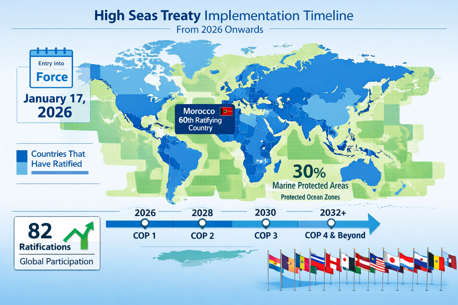
- The High Seas Treaty became legally binding on January 17, 2026, after achieving 60 ratifications in September 2025, with 82 countries ratified as of January 2026.[2]
- Environmental impact assessments (EIAs) are now mandatory for any planned activity under a Party's control that could affect the high seas or seabed.[2]
- Marine protected areas (MPAs) can now be established on the high seas, supporting the global objective to protect 30% of the ocean by 2030.[2]
- Surveyors must deploy remote sensing and advanced technologies to collect baseline biodiversity data in protected zones where traditional survey methods prove impractical.
- The first Conference of Parties (CoP1) will meet within one year of the treaty's entry into force, establishing governance structures and decision-making processes that will shape ocean protection for decades.[2]
Understanding the High Seas Treaty Framework and Its Global Impact
The Path to Legal Force and International Adoption
The journey to the High Seas Treaty's implementation represents years of international negotiation and diplomatic effort. Morocco's ratification on September 19, 2025, made it the critical 60th country to ratify, triggering the 120-day countdown to the treaty's entry into force.[3] By October 2025, the agreement had been signed by 145 countries and ratified by 75 countries, demonstrating significant global momentum despite incomplete universal adoption.[3]
As of January 14, 2026—just days before the treaty became binding—82 ratifications had been secured, with additional countries expected to join in the following days.[2] This rapid adoption reflects growing international recognition that ocean protection requires coordinated global action rather than fragmented national approaches.
The treaty's entry into force marks more than a symbolic milestone. It creates legally binding obligations for participating nations and establishes institutional mechanisms for enforcement and compliance. Countries must now promote the treaty's objectives when participating in other international bodies governing shipping, fisheries, and seabed mining.[2]
Key Provisions Affecting Marine Biodiversity Surveys
The treaty introduces several provisions with direct implications for biodiversity surveyors working in international waters:
Environmental Impact Assessment Requirements: From the treaty's entry into force, any planned activity under a Party's control that could affect the high seas or seabed must follow environmental impact assessment (EIA) processes.[2] Governments are required to publicly notify such activities, creating transparency and accountability mechanisms that depend on robust baseline data.
Marine Protected Area Establishment: The treaty provides tools to create marine protected areas (MPAs) on the high seas, with an objective to protect 30% of the ocean by 2030.[2] This ambitious target—often referred to as "30×30"—requires comprehensive biodiversity surveys to identify priority areas for protection.
Institutional Architecture Development: The UN Preparatory Commission is currently shaping the treaty's institutional architecture, developing bodies and decision-making processes for adoption at the first Conference of Parties.[2] These structures will determine how survey data is collected, standardized, and utilized in conservation decisions.
Similar to how biodiversity surveyors benefit both nature and developers in terrestrial environments, marine biodiversity professionals must balance conservation objectives with practical development considerations in ocean spaces.
The BBNJ First Movers Coalition and Implementation Support
Progress toward developing the first generation of high seas MPAs is being supported by the BBNJ First Movers coalition—a group of champion countries ready to move from agreement to action.[4] This coalition recognizes that 2026 is a vital year for delivery, where decisions about participation, governance, financing, and marine protected areas will shape ocean governance for decades to come.[4]
Countries are being encouraged to begin identifying important high seas sites requiring protection, so proposals can be brought forward at future Conferences of the Parties.[2] This identification process depends entirely on comprehensive biodiversity surveys that document species distribution, habitat quality, ecosystem function, and anthropogenic threats.
Ocean Protection Agreements and Marine Biodiversity Surveys: Field Survey Methodologies for High Seas Applications
Remote Sensing Technologies Transforming Marine Surveys
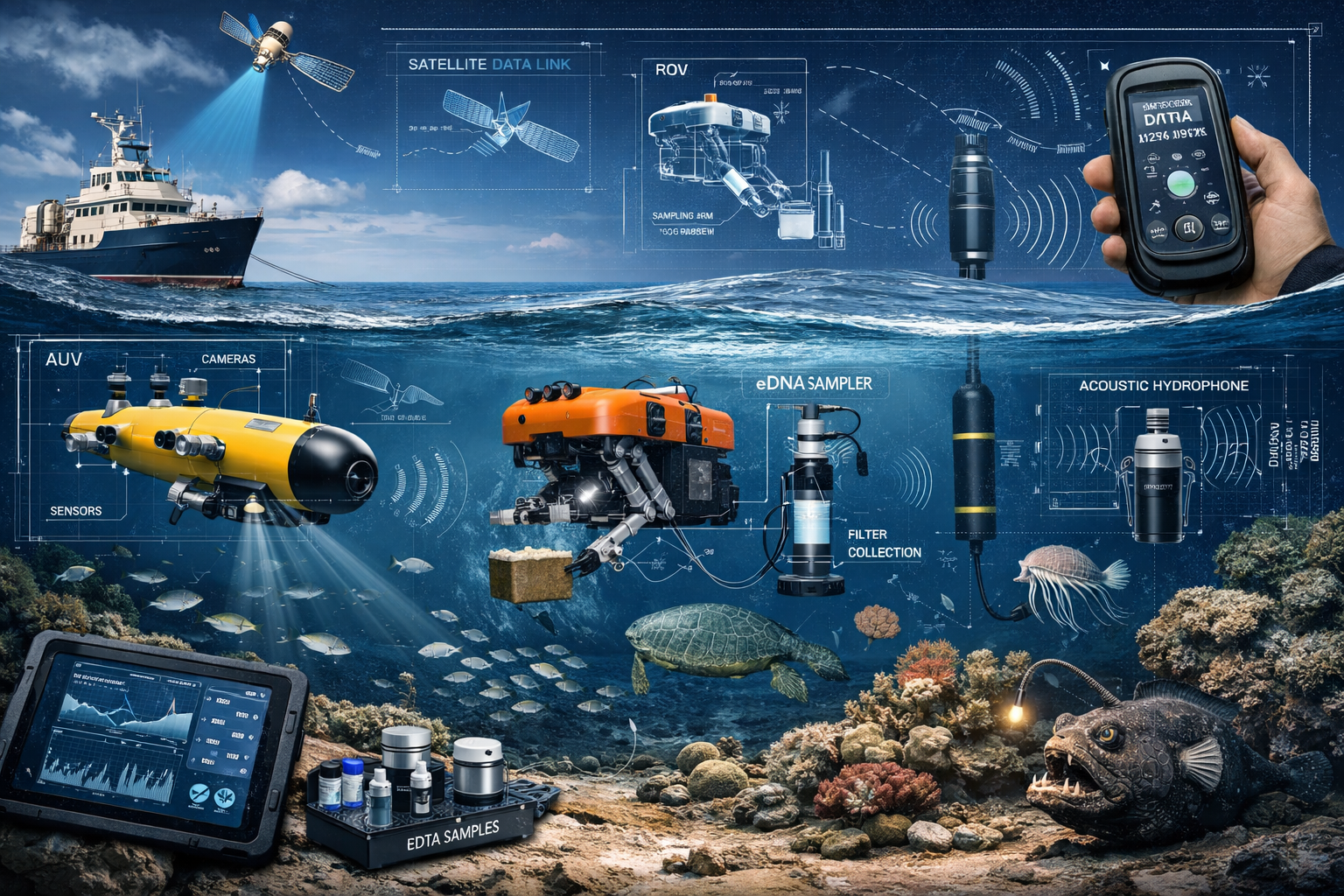
Traditional marine biodiversity surveys relied heavily on ship-based sampling, visual observations, and limited underwater exploration. The scale and remoteness of high seas environments make these approaches impractical for comprehensive baseline assessments. Remote sensing technologies now provide surveyors with powerful tools to monitor marine ecosystems across vast spatial scales.
Satellite Remote Sensing: Advanced satellite systems can detect ocean color variations indicating phytoplankton concentrations, sea surface temperature anomalies revealing upwelling zones, and chlorophyll patterns identifying productive marine areas. These data layers help surveyors identify biodiversity hotspots worthy of detailed investigation.
Autonomous Underwater Vehicles (AUVs): These programmable robots can conduct systematic surveys of seafloor habitats, collecting high-resolution imagery, bathymetric data, and water quality measurements without requiring constant human operation. AUVs extend survey capabilities to depths and durations impossible for human divers.
Remotely Operated Vehicles (ROVs): Unlike autonomous systems, ROVs remain tethered to surface vessels and allow real-time human control. They prove invaluable for detailed habitat characterization, specimen collection, and investigating specific features identified through broader remote sensing.
Acoustic Monitoring Systems: Passive acoustic monitoring detects marine mammal vocalizations, fish sounds, and anthropogenic noise across extended time periods. These systems provide biodiversity data without visual observation, particularly valuable for monitoring cetaceans and other vocal species.
Environmental DNA (eDNA) Sampling: Water samples collected from various depths and locations contain genetic material from organisms that have passed through or inhabited those areas. Laboratory analysis of eDNA reveals species presence and relative abundance without direct observation or capture.
Establishing Baseline Biodiversity Data in Protected Zones
The effectiveness of marine protected areas depends on robust baseline data documenting pre-protection conditions. Surveyors conducting Ocean Protection Agreements and Marine Biodiversity Surveys: Post-2026 High Seas Treaty Field Applications must establish comprehensive baselines addressing multiple biodiversity dimensions:
Species Inventory and Distribution: Documenting which species occur in proposed protected areas, their relative abundances, and spatial distribution patterns. This requires taxonomic expertise, standardized sampling protocols, and adequate spatial coverage.
Habitat Characterization: Mapping seafloor habitats including seamounts, hydrothermal vents, cold-water coral reefs, and abyssal plains. Habitat maps provide context for species distributions and identify features requiring special protection.
Ecosystem Function Assessment: Beyond cataloging species, surveyors must assess ecosystem processes including primary productivity, nutrient cycling, predator-prey relationships, and connectivity with adjacent ecosystems.
Threat Documentation: Baseline surveys should document existing anthropogenic impacts including fishing pressure, pollution levels, shipping traffic, and climate change indicators. This establishes reference points for measuring protection effectiveness.
Temporal Variation: Single-time surveys provide limited information. Repeated surveys across seasons and years reveal natural variation patterns, helping distinguish protection effects from background fluctuations.
The principles of comprehensive baseline assessment mirror those applied in terrestrial contexts, such as conducting biodiversity impact assessments for developers, though marine applications face unique logistical and technical challenges.
Standardization and Quality Assurance in Marine Surveys
The international nature of high seas governance requires standardized survey methodologies ensuring data comparability across regions, time periods, and survey teams. Quality assurance protocols for Ocean Protection Agreements and Marine Biodiversity Surveys should address:
| Quality Component | Implementation Approach |
|---|---|
| Taxonomic Standardization | Use internationally recognized taxonomic authorities and nomenclature; maintain voucher specimens for verification |
| Sampling Protocol Consistency | Develop detailed standard operating procedures (SOPs) for all survey methods; train personnel to consistent standards |
| Equipment Calibration | Regular calibration of sensors, cameras, and measurement devices against known standards |
| Data Management | Structured databases with metadata documentation; version control; secure backup systems |
| Spatial Accuracy | High-precision GPS/GNSS positioning; coordinate system standardization; positional uncertainty documentation |
| Temporal Documentation | Precise time-stamping of all observations; time zone standardization; survey effort quantification |
| Quality Control Review | Independent data verification; outlier detection; completeness checking before finalization |
These quality assurance measures ensure that survey data can support rigorous scientific analysis, regulatory decision-making, and long-term monitoring programs tracking protection effectiveness.
Environmental Impact Assessment Requirements Under Ocean Protection Agreements and Marine Biodiversity Surveys: Post-2026 High Seas Treaty Field Applications for Surveyors
Mandatory EIA Processes for High Seas Activities
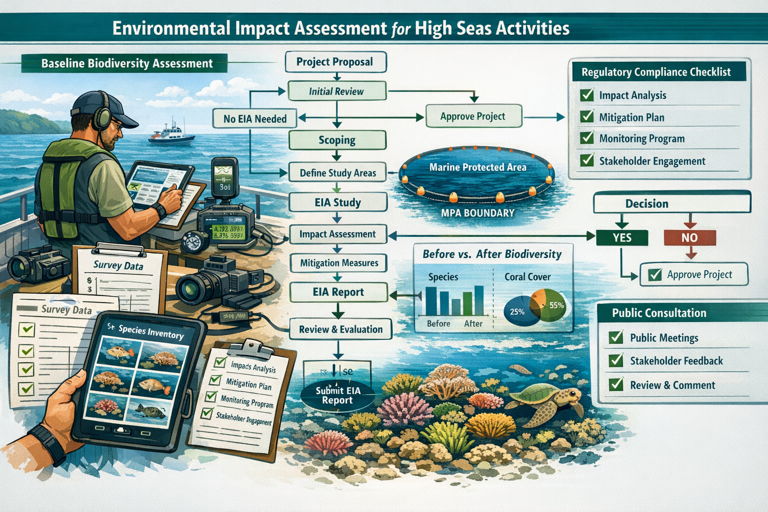
The High Seas Treaty establishes environmental impact assessment (EIA) as a mandatory requirement for planned activities that could affect international waters or the seabed.[2] This represents a fundamental shift from voluntary best practices to legally binding obligations for participating nations.
Activities potentially requiring EIA include:
- Deep-sea mining operations extracting minerals from the seabed
- Large-scale fishing operations using industrial vessels and equipment
- Offshore energy development including oil, gas, and renewable energy installations
- Shipping route establishment through sensitive marine areas
- Scientific research activities with potential environmental impacts
- Waste disposal or other discharge into high seas environments
For each activity, responsible governments must publicly notify the international community and conduct comprehensive environmental assessments before authorization.[2] These assessments depend on baseline biodiversity data that only qualified surveyors can provide.
Survey Components of Comprehensive EIAs
Environmental impact assessments for high seas activities require biodiversity surveys addressing specific questions about potential impacts:
Pre-Activity Baseline Assessment: Documenting existing conditions before activity commencement. This establishes the reference point against which impacts will be measured. Surveyors must characterize species assemblages, habitat conditions, and ecosystem functions in areas potentially affected by proposed activities.
Impact Prediction Modeling: Using baseline data to predict how proposed activities might alter marine ecosystems. This requires understanding species sensitivities, habitat vulnerabilities, and ecosystem resilience. Surveyors contribute ecological expertise informing these predictions.
Alternative Assessment: Evaluating different activity designs, locations, or timing to minimize environmental impacts. Comparative surveys of alternative sites help identify options with lower biodiversity impacts.
Mitigation Measure Design: Developing specific actions to avoid, minimize, or compensate for unavoidable impacts. Survey data identifies critical habitats requiring avoidance, sensitive periods requiring activity restrictions, and appropriate compensation ratios.
Monitoring Program Development: Establishing protocols for tracking actual impacts during and after activities. Survey methodologies developed during baseline assessment provide templates for ongoing monitoring.
The terrestrial equivalent of these EIA components can be seen in biodiversity net gain assessments, which similarly require baseline documentation, impact prediction, and monitoring protocols, though marine applications involve different species, habitats, and assessment challenges.
Public Notification and Transparency Requirements
The treaty's requirement for public notification of planned activities[2] creates unprecedented transparency in high seas governance. This transparency depends on accessible, understandable communication of survey findings and EIA results.
Surveyors must therefore develop skills in:
- Data visualization making complex biodiversity information accessible to non-specialists
- Summary reporting distilling technical findings into key conclusions
- Stakeholder communication explaining survey methods and limitations to diverse audiences
- Public database contribution sharing data through international repositories and clearinghouses
This transparency serves multiple purposes: enabling public scrutiny of environmental decisions, facilitating scientific peer review, supporting cumulative impact assessment across multiple activities, and building the knowledge base for adaptive management.
Enforcement, Compliance, and the Role of Biodiversity Monitoring
Implementation and Compliance Committee Functions
The High Seas Treaty establishes an Implementation and Compliance Committee responsible for reviewing implementation, making recommendations, and resolving disputes.[3] This committee depends on objective data documenting whether parties fulfill their obligations and whether protection measures achieve intended outcomes.
Biodiversity surveyors contribute to compliance monitoring through:
Baseline Documentation: Establishing pre-protection conditions against which compliance is measured. If a marine protected area aims to maintain coral reef health, baseline surveys document initial reef condition.
Protection Effectiveness Monitoring: Conducting repeated surveys within protected areas to assess whether biodiversity is maintained or improved. Declining biodiversity despite protection indicates compliance failures.
Impact Verification: Surveying areas affected by authorized activities to verify that actual impacts match EIA predictions and remain within authorized limits.
Unauthorized Activity Detection: Survey data revealing unexpected biodiversity declines or habitat damage may indicate unauthorized activities requiring investigation.
The committee's effectiveness depends on country-level implementation and reporting[3], which in turn depends on national capacity for marine biodiversity monitoring. This creates opportunities for surveyors to support government agencies developing monitoring programs.
Adaptive Management and Survey Data Feedback Loops
Effective ocean governance requires adaptive management—adjusting protection strategies based on monitoring results. Survey data creates feedback loops informing management decisions:
- Initial surveys establish baselines and inform MPA designation
- Protection measures are implemented based on survey findings
- Monitoring surveys track biodiversity responses to protection
- Data analysis reveals whether protection achieves objectives
- Management adjustments modify protection measures as needed
- Continued monitoring assesses adjustment effectiveness
This cyclical process requires sustained surveying capacity rather than one-time assessments. Surveyors must design monitoring programs that are:
- Scientifically rigorous to detect meaningful changes
- Cost-effective to sustain over decades
- Standardized for comparability across time
- Responsive to emerging management questions
- Integrated with other monitoring programs
Similar adaptive approaches are employed in terrestrial conservation, such as achieving biodiversity net gain without risk through careful monitoring and adjustment.
Capacity Building for Developing Nations
The High Seas Treaty recognizes that effective implementation requires capacity building, particularly for developing nations with limited marine survey expertise and resources. The treaty's success depends on equitable participation where all nations can contribute to and benefit from ocean protection.
Capacity building priorities for Ocean Protection Agreements and Marine Biodiversity Surveys include:
Technical Training: Developing expertise in remote sensing technologies, eDNA analysis, acoustic monitoring, and other advanced survey methods.
Equipment Access: Providing developing nations with survey equipment including AUVs, ROVs, acoustic recorders, and water sampling systems.
Data Analysis Skills: Training in statistical analysis, species identification, habitat classification, and impact assessment methodologies.
Institutional Development: Establishing national agencies and programs for marine biodiversity monitoring with sustainable funding and career pathways.
International Collaboration: Facilitating partnerships between developed and developing nations for joint surveys, data sharing, and knowledge exchange.
Surveyors from developed nations can contribute to capacity building through training programs, technology transfer, collaborative research projects, and mentorship relationships with emerging marine biodiversity professionals.
Practical Applications: Survey Planning for High Seas Protected Areas
Site Selection and Prioritization for Marine Protected Areas
The treaty's objective to protect 30% of the ocean by 2030[2] requires strategic site selection identifying areas where protection delivers maximum biodiversity benefit. Survey data informs this prioritization through multiple criteria:
Biodiversity Significance: Areas supporting high species richness, endemic species, or rare habitats receive priority. Surveys document species assemblages enabling biodiversity comparisons across potential sites.
Ecological Importance: Sites providing critical ecosystem functions—such as nursery grounds, migration corridors, or nutrient upwelling zones—merit protection regardless of species counts. Surveys reveal these functional roles.
Threat Exposure: Areas facing imminent threats from fishing, mining, or pollution gain urgency for protection. Survey data documents threat levels and habitat degradation.
Representativeness: Protected area networks should represent the full range of marine ecosystems. Surveys enable habitat classification and gap analysis identifying underrepresented ecosystems.
Connectivity: Marine protected areas function more effectively when connected, allowing larval dispersal and species movement. Oceanographic modeling combined with survey data reveals connectivity patterns.
Feasibility: Protection success depends on enforcement capacity, stakeholder support, and management resources. Survey data helps identify sites where protection is both needed and achievable.
Countries are encouraged to begin identifying important high seas sites requiring protection so proposals can be brought forward at future Conferences of the Parties.[2] This identification process creates immediate demand for comprehensive biodiversity surveys in international waters.
Designing Survey Programs for Remote Ocean Environments
Conducting Ocean Protection Agreements and Marine Biodiversity Surveys: Post-2026 High Seas Treaty Field Applications for Surveyors in remote high seas locations presents unique logistical challenges requiring careful planning:
Vessel Selection and Scheduling: Research vessels capable of extended high seas operations are limited and expensive. Survey programs must optimize vessel time through detailed cruise planning, multi-objective surveys, and efficient sampling designs.
Weather and Seasonal Considerations: High seas environments experience severe weather limiting survey windows. Seasonal planning must account for storm patterns, sea ice, and biological cycles affecting species detectability.
Depth and Pressure Limitations: Many high seas areas exceed depths accessible to conventional survey equipment. Deep-sea surveys require specialized pressure-resistant equipment and extended deployment times.
Spatial Coverage Strategies: Comprehensive coverage of vast ocean areas is impossible. Surveyors must employ statistical sampling designs, stratified random sampling, or targeted surveys of representative habitats.
Multi-Method Integration: No single survey method captures complete biodiversity. Effective programs integrate complementary methods—combining satellite remote sensing, AUV surveys, ROV observations, trawl sampling, acoustic monitoring, and eDNA analysis.
Data Management at Sea: Limited connectivity in remote locations requires robust onboard data management systems with backup protocols preventing data loss.
Safety Protocols: High seas surveys involve inherent risks requiring comprehensive safety planning, emergency procedures, and risk mitigation strategies.
These planning considerations parallel those in complex terrestrial surveys, though marine applications face amplified logistical challenges and costs.
Cost Considerations and Funding Mechanisms
High seas biodiversity surveys represent significant financial investments. Understanding cost drivers helps surveyors develop realistic budgets and identify funding sources:
Major Cost Components:
- Vessel charter or operation (often $10,000-50,000+ per day)
- Specialized equipment purchase or rental
- Personnel salaries for survey teams
- Laboratory analysis (especially eDNA sequencing)
- Data management and analysis
- Travel and logistics
- Permits and regulatory compliance
Potential Funding Sources:
- National government agencies implementing treaty obligations
- International organizations supporting ocean conservation
- Research grants from scientific funding bodies
- Public-private partnerships with sustainable ocean economy stakeholders
- Philanthropic foundations focused on ocean protection
- Multilateral development banks supporting capacity building
The treaty's implementation will likely create dedicated funding mechanisms supporting marine biodiversity surveys in developing nations and priority conservation areas. Surveyors should monitor Conference of Parties decisions regarding financial architecture and access procedures.
Just as terrestrial projects must consider the cost of biodiversity units and statutory credits, marine conservation requires understanding economic frameworks supporting survey work and protection implementation.
Future Directions: Emerging Technologies and Evolving Survey Standards
Artificial Intelligence and Automated Species Identification
Artificial intelligence (AI) and machine learning are transforming marine biodiversity surveys by automating labor-intensive tasks:
Image Analysis: AI algorithms can identify species in underwater photographs and videos, processing thousands of images faster than human analysts. Deep learning models trained on reference collections achieve increasing accuracy for many taxonomic groups.
Acoustic Pattern Recognition: Machine learning classifies marine mammal vocalizations, fish sounds, and anthropogenic noise from acoustic recordings, enabling automated processing of years of continuous monitoring data.
eDNA Sequence Analysis: AI assists in matching environmental DNA sequences to reference databases, identifying species from genetic material with improving accuracy as reference libraries expand.
Anomaly Detection: Machine learning identifies unusual patterns in survey data that may indicate rare species, emerging threats, or data quality issues requiring investigation.
These technologies don't eliminate the need for expert surveyors but rather augment human capabilities, allowing professionals to focus on complex interpretation, quality control, and adaptive survey design rather than repetitive data processing.
Citizen Science and Collaborative Monitoring
While high seas surveys require specialized vessels and equipment, citizen science can contribute to ocean biodiversity monitoring through:
- Vessel-of-opportunity programs where commercial ships, fishing vessels, or recreational boats collect standardized observations
- Satellite tagging data from animals tagged by researchers but observed globally
- Photo identification networks where anyone encountering marine megafauna contributes identification photographs
- Coastal observation programs monitoring species that migrate between coastal and high seas environments
Integrating citizen science data with professional surveys expands spatial and temporal coverage while engaging public stakeholders in ocean protection. However, quality control protocols must ensure data reliability for regulatory applications.
Climate Change Monitoring Integration
Ocean biodiversity surveys increasingly integrate climate change monitoring, recognizing that protection effectiveness depends on ecosystem resilience to changing conditions:
Temperature and Chemistry Monitoring: Surveys routinely measure ocean temperature, pH, dissolved oxygen, and carbonate chemistry alongside biological observations, revealing climate impacts on marine ecosystems.
Range Shift Documentation: Repeated surveys track species distribution changes as warming waters drive poleward migrations and depth redistributions.
Phenology Changes: Monitoring seasonal timing of biological events—such as plankton blooms, fish spawning, or whale migrations—reveals climate-driven disruptions to ecological synchrony.
Resilience Indicators: Survey data identifies ecosystem characteristics associated with climate resilience, helping prioritize protection of areas likely to maintain biodiversity despite changing conditions.
This integration recognizes that static protection is insufficient—effective ocean governance must account for dynamic ecosystems responding to global environmental change.
Professional Development and Career Opportunities for Marine Biodiversity Surveyors
Required Skills and Qualifications
Professionals pursuing careers in Ocean Protection Agreements and Marine Biodiversity Surveys: Post-2026 High Seas Treaty Field Applications typically need:
Educational Background:
- Bachelor's degree minimum in marine biology, oceanography, ecology, or related field
- Advanced degrees (Master's or Ph.D.) for senior positions
- Specialized training in survey methodologies, statistical analysis, and relevant technologies
Technical Skills:
- Species identification expertise for relevant taxonomic groups
- Proficiency with survey equipment (AUVs, ROVs, acoustic systems, sampling gear)
- Geographic Information Systems (GIS) and spatial analysis
- Statistical software and data analysis
- Remote sensing interpretation
- eDNA collection and analysis protocols
Field Experience:
- Sea time on research vessels
- Diving certifications for shallow water surveys
- Experience with challenging environmental conditions
- Safety training and emergency response
Professional Competencies:
- Report writing and scientific communication
- Project management and logistics coordination
- Regulatory compliance and permitting
- Stakeholder engagement and collaboration
- Adaptive problem-solving in resource-limited settings
Many of these competencies parallel those required for terrestrial biodiversity work, as discussed in resources about biodiversity net gain explained, though marine applications require additional specialized training.
Career Pathways and Employment Sectors
The High Seas Treaty's implementation creates diverse career opportunities for qualified marine biodiversity surveyors:
Government Agencies: National environmental, fisheries, and ocean management agencies require surveyors to fulfill treaty obligations, conduct EIAs, and monitor protected areas.
International Organizations: UN bodies, regional fisheries management organizations, and international conservation groups need survey expertise supporting global ocean governance.
Research Institutions: Universities and research centers conduct fundamental science informing conservation policy while training the next generation of marine biodiversity professionals.
Environmental Consulting: Private firms provide survey services to governments, industry, and NGOs implementing protection measures or conducting impact assessments.
Non-Governmental Organizations: Conservation NGOs employ surveyors for advocacy campaigns, protection planning, and monitoring program implementation.
Industry: Fishing companies, offshore energy developers, and other ocean economy sectors increasingly employ biodiversity professionals ensuring sustainable operations.
The field offers opportunities ranging from entry-level field technicians to senior scientists leading international programs, with career advancement typically requiring advanced education, specialized expertise, and demonstrated leadership.
Professional Networks and Continuing Education
Staying current in this rapidly evolving field requires engagement with professional networks and ongoing learning:
Professional Societies:
- Society for Marine Mammalogy
- International Society for Reef Studies
- American Fisheries Society
- Marine Technology Society
- Society for Conservation Biology (Marine Section)
Specialized Training Programs:
- AUV/ROV operation and maintenance courses
- eDNA sampling and analysis workshops
- Advanced statistical methods for ecological data
- Remote sensing and satellite data interpretation
- EIA methodology and regulatory compliance
Conferences and Workshops:
- International Marine Conservation Congress
- Ocean Sciences Meeting
- Regional marine science symposia
- Technology-specific conferences (e.g., Autonomous Underwater Vehicles)
Online Resources and Databases:
- Ocean Biodiversity Information System (OBIS)
- Global Biodiversity Information Facility (GBIF)
- International Union for Conservation of Nature (IUCN) Red List
- Species identification guides and taxonomic resources
Continuous professional development ensures surveyors remain proficient with emerging technologies, evolving standards, and new regulatory requirements as the High Seas Treaty implementation progresses.
Challenges and Solutions in High Seas Biodiversity Survey Implementation
Taxonomic Expertise Gaps and Solutions
A critical challenge facing marine biodiversity surveys is the shortage of taxonomic experts capable of identifying species, particularly for less-studied groups like deep-sea invertebrates, microorganisms, and rare taxa.
Solutions include:
- DNA barcoding and metabarcoding reducing dependence on morphological identification
- AI-assisted identification for well-documented groups with extensive reference collections
- Parataxonomist training developing identification skills among technicians and local communities
- International expert networks providing remote identification support through photograph and specimen sharing
- Investment in taxonomic research training new systematists and completing species inventories
The taxonomic impediment particularly affects developing nations with limited access to identification expertise, making capacity building and technology transfer essential for equitable treaty implementation.
Data Standardization and Interoperability
Marine biodiversity data collected by different nations, institutions, and survey programs must be standardized and interoperable to support international ocean governance.
Challenges include:
- Varying survey methodologies producing non-comparable data
- Different taxonomic authorities and naming conventions
- Inconsistent data formats and metadata standards
- Limited data sharing due to proprietary concerns or technical barriers
- Language barriers in international data exchange
Solutions involve:
- Adopting international standards like Darwin Core for biodiversity data
- Using controlled vocabularies and ontologies for consistent terminology
- Implementing FAIR principles (Findable, Accessible, Interoperable, Reusable) for data management
- Contributing to international databases like OBIS and GBIF
- Developing data sharing agreements and policies for treaty implementation
The Conference of Parties will likely establish data standards and sharing requirements, making early adoption of best practices strategically advantageous.
Balancing Scientific Rigor with Practical Constraints
High seas surveys face tension between scientific ideals and practical realities:
Scientific Ideals:
- Comprehensive spatial coverage
- Intensive sampling effort
- Replicated measurements
- Long-term monitoring
- Taxonomic completeness
Practical Constraints:
- Limited vessel availability and cost
- Weather and safety restrictions
- Equipment limitations
- Budget constraints
- Time pressures for regulatory decisions
Balanced Approaches:
- Statistically designed sampling maximizing information from limited effort
- Tiered survey strategies with broad reconnaissance followed by targeted intensive surveys
- Multi-objective surveys combining multiple research questions
- Adaptive sampling adjusting effort based on preliminary findings
- Transparent uncertainty communication acknowledging data limitations
Effective surveyors develop pragmatic approaches delivering defensible results within real-world constraints, similar to how terrestrial professionals must balance ideals with practicalities when creating biodiversity plans for developers.
Conclusion: Charting the Course for Ocean Protection Through Biodiversity Surveys
The High Seas Treaty's entry into force on January 17, 2026, represents a watershed moment in global ocean governance, transforming nearly two-thirds of the world's ocean from an unregulated frontier into an internationally managed commons.[2] This transformation creates both unprecedented opportunities and substantial responsibilities for marine biodiversity surveyors.
Ocean Protection Agreements and Marine Biodiversity Surveys: Post-2026 High Seas Treaty Field Applications for Surveyors will fundamentally shape how effectively the international community protects marine ecosystems, achieves the 30×30 conservation target, and balances ocean protection with sustainable use. The quality, comprehensiveness, and accessibility of biodiversity data collected by professional surveyors will determine whether marine protected areas are strategically located, whether environmental impact assessments accurately predict consequences, and whether adaptive management improves protection effectiveness over time.
The coming years—particularly 2026 as the vital year for delivery[4]—will establish precedents, standards, and institutional structures influencing ocean governance for decades. Surveyors who develop expertise in remote sensing technologies, environmental DNA analysis, deep-sea survey methods, and international regulatory frameworks will find themselves at the forefront of this historic conservation effort.
Actionable Next Steps for Surveyors
For Early-Career Professionals:
- Pursue specialized training in emerging survey technologies (AUVs, ROVs, eDNA, acoustic monitoring)
- Gain sea time experience through research programs, internships, or volunteer opportunities
- Develop statistical and data analysis skills essential for modern biodiversity assessment
- Engage with professional societies and networks in marine conservation
- Monitor Conference of Parties decisions establishing survey standards and requirements
For Established Professionals:
- Adapt existing survey programs to align with High Seas Treaty requirements
- Participate in international working groups developing survey standards and protocols
- Contribute to capacity building efforts supporting developing nations
- Establish partnerships enabling high seas survey access and collaboration
- Publish survey methodologies and findings in accessible formats supporting treaty implementation
For Institutions and Organizations:
- Invest in survey equipment and infrastructure supporting high seas research
- Develop training programs building marine biodiversity survey capacity
- Establish data management systems ensuring FAIR principles compliance
- Create funding mechanisms supporting sustained monitoring programs
- Engage in policy processes shaping treaty implementation at national and international levels
The ocean's future depends on the quality of information guiding protection decisions. Biodiversity surveyors possess the expertise, technologies, and commitment to provide that information, ensuring that the High Seas Treaty fulfills its promise of a new era in ocean governance—one where marine ecosystems are understood, valued, and protected for generations to come. 🌊🔬
The journey from treaty ratification to effective ocean protection is just beginning. Surveyors who embrace this challenge will help write the next chapter in humanity's relationship with the sea.
References
[1] Track Progress – https://highseasalliance.org/treaty-ratification/track-progress/
[2] Historic High Seas Treaty Enters Into Force Launching A New Era Of Global Ocean Governance – https://highseasalliance.org/2026/01/16/historic-high-seas-treaty-enters-into-force-launching-a-new-era-of-global-ocean-governance/
[3] High Seas Treaty – https://www.britannica.com/event/High-Seas-Treaty
[4] Guest Opinion Jonathan Kelsey High Seas Treaty A New Dawn For The Ocean – https://oceanographicmagazine.com/news/guest-opinion-jonathan-kelsey-high-seas-treaty-a-new-dawn-for-the-ocean/
[5] Treaty Negotiations – https://highseasalliance.org/treaty-negotiations/
[6] High Seas Treaty Ratification – https://www.nature.org/en-us/what-we-do/our-insights/perspectives/high-seas-treaty-ratification/
[7] Ocean Sustainability Rising Tensions – https://www.sei.org/perspectives/ocean-sustainability-rising-tensions/
[8] The High Seas Treaty A Win For Our Ocean Humanity And Multilateralism – https://unfoundation.org/blog/post/the-high-seas-treaty-a-win-for-our-ocean-humanity-and-multilateralism/
