
The icy waters surrounding Antarctica are transforming at an unprecedented pace. As 2026 unfolds, the Southern Ocean stands at a critical juncture—recognized as one of the fastest changing regions on Earth, facing high risk of ecosystem failure unless immediate protective action is taken.[1] For ecologists working in these extreme environments, understanding and documenting these Southern Ocean Biophysical Shifts: 2026 Biodiversity Survey Protocols for Ecologists Amid Accelerating Changes has become more urgent than ever.
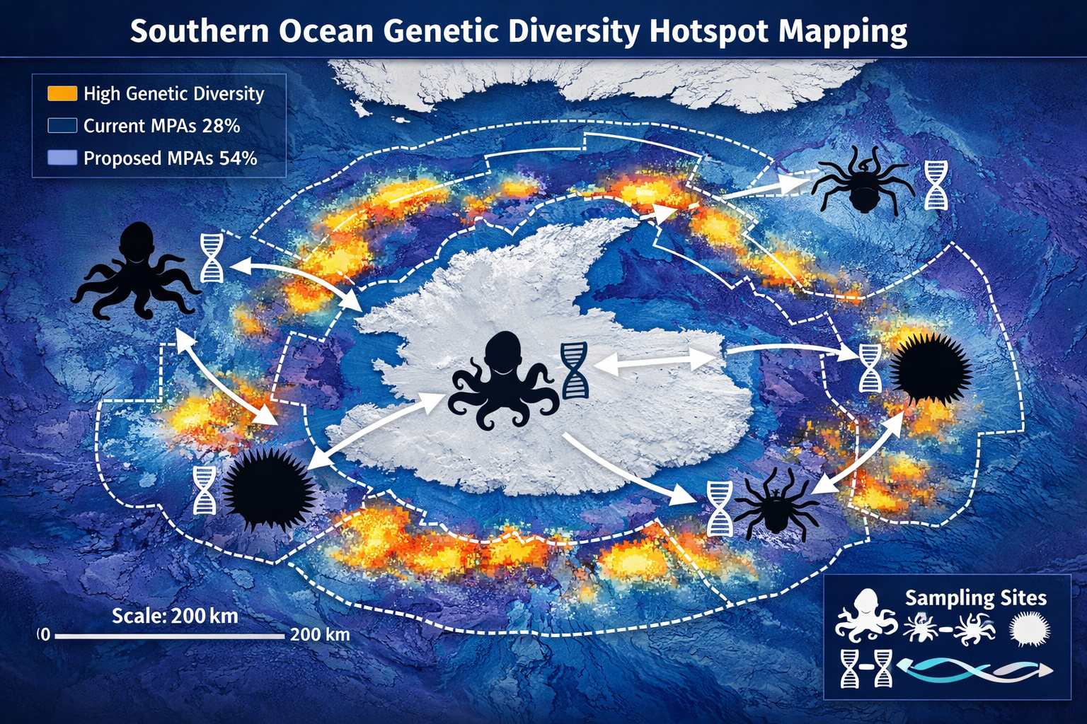
Recent groundbreaking research published in Current Biology has identified genetic diversity hotspots across the Southern Ocean seafloor for the first time, revealing that only 28% of these critical areas currently receive protection through marine protected areas (MPAs).[1] This discovery comes at a pivotal moment, as a new United Nations treaty governing biodiversity in areas beyond national jurisdiction entered into force on January 17, 2026, covering roughly 60% of the world's oceans.[3]
This comprehensive guide explores the Southern Ocean Biophysical Shifts: 2026 Biodiversity Survey Protocols for Ecologists Amid Accelerating Changes, providing field-ready methodologies that ecologists can implement to quantify impacts on marine biodiversity. Drawing from the latest scientific findings presented at the Ocean Sciences Meeting 2026 and integrating lessons from decades of international Antarctic research collaboration, these protocols offer a roadmap for documenting change and contributing to global conservation efforts.
Key Takeaways
- 🧬 Genetic hotspots mapped: Scientists have identified priority conservation areas across the Southern Ocean using genetic data from octopus, sea spiders, and urchins—but only 28% are currently protected.[1]
- 🌊 Accelerating change: The Southern Ocean faces ecosystem failure risk due to rapid climate-driven biophysical shifts, making standardized survey protocols essential for tracking biodiversity loss.
- 📊 New survey frameworks: 2026 protocols integrate genetic sampling, environmental monitoring, and biodiversity impact assessments aligned with international conservation standards.
- 🌍 Global governance shift: The UN high seas treaty (effective January 2026) creates new mechanisms for marine protected areas and environmental impact assessments in international waters.[3]
- 🔬 Resilience through diversity: Ecosystems with high genetic diversity demonstrate greater resilience and adaptation capacity to environmental change—making genetic monitoring a priority.[1]
Understanding Southern Ocean Biophysical Shifts in 2026
The Changing Antarctic Marine Environment
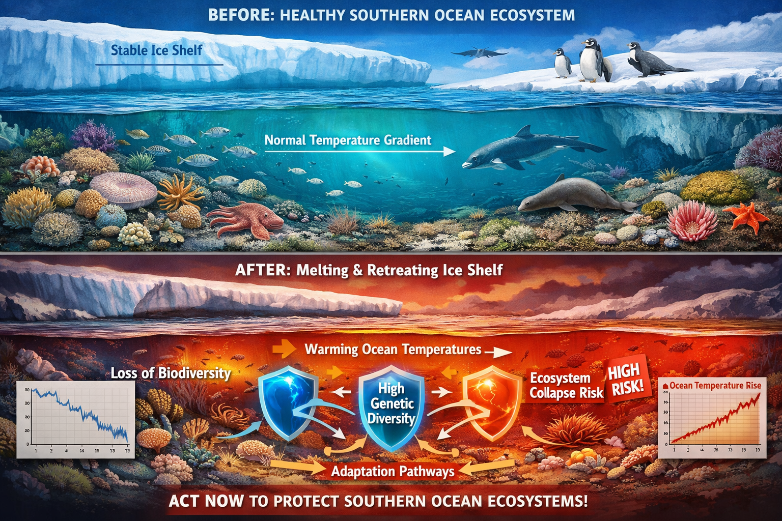
The Southern Ocean encircles Antarctica and plays a fundamental role in global ocean circulation, climate regulation, and carbon storage. However, this critical ecosystem is experiencing profound transformations driven by climate change, ocean acidification, and shifting oceanographic conditions. These biophysical shifts encompass changes in water temperature, salinity, ice coverage, nutrient availability, and current patterns—all of which cascade through marine food webs and alter biodiversity patterns.[1][2]
Recent data presented at the Ocean Sciences Meeting 2026 in Glasgow highlights the severity of these changes. Scientists are documenting marine heatwaves, altered sea ice dynamics, and shifting species distributions across the Southern Ocean.[2] These environmental changes don't occur in isolation; they interact in complex ways that can amplify impacts on marine life.
Genetic Diversity Hotspots: A New Conservation Priority
In January 2026, researchers from Securing Antarctica's Environmental Future (SAEF) published landmark findings that fundamentally change how we approach Southern Ocean conservation. By synthesizing genetic data from seafloor species including octopus, sea spiders, and urchins, they created the first comprehensive map of genetic diversity hotspots, connectivity corridors, and divergence zones across the region.[1][8]
This research reveals something crucial: ecosystems with high genetic diversity are more resilient and better able to adapt to climate and environmental change.[1] Genetic diversity provides the raw material for adaptation—populations with greater genetic variation have more options for responding to new environmental conditions.
The findings are sobering. Currently, only 28% of identified genetic hotspots receive protection through established marine protected areas. However, if proposed MPAs are adopted alongside maintaining existing protected zones, coverage would increase to approximately 54%—nearly doubling current protection levels.[1] This represents a significant opportunity for conservation action in 2026 and beyond.
The Global Context: New Ocean Governance
The conservation landscape for the Southern Ocean shifted dramatically on January 17, 2026, when the United Nations treaty governing biodiversity in areas beyond national jurisdiction entered into force.[3] This historic agreement covers roughly 60% of the ocean and introduces several critical mechanisms:
- Marine protected areas in international waters
- Environmental impact assessments for activities affecting marine biodiversity
- Benefit-sharing from marine genetic resources
- Capacity building support for developing nations
A preparatory commission is currently finalizing operational rules for the first conference of parties scheduled for later in 2026, addressing funding mechanisms, institutional staffing, and procedures for proposing new protected areas.[3] For ecologists conducting biodiversity surveys in the Southern Ocean, this treaty framework creates new opportunities to contribute data that informs international conservation decisions.
Similar to how biodiversity impact assessments guide development projects, these international frameworks require robust baseline data and monitoring protocols to track ecosystem health over time.
Southern Ocean Biophysical Shifts: 2026 Biodiversity Survey Protocols Overview
Essential Biodiversity Variables for Antarctic Waters
Standardized survey protocols begin with identifying what to measure. The concept of Essential Biodiversity Variables (EBVs) provides a framework for selecting measurements that are scientifically relevant, feasible to collect, and comparable across studies.[5] For the Southern Ocean, priority EBVs include:
Genetic Composition Variables:
- Genetic diversity within populations
- Genetic differentiation between populations
- Effective population size
- Inbreeding coefficients
Species Population Variables:
- Species abundance and distribution
- Population structure and demographics
- Migration and connectivity patterns
Community Composition Variables:
- Species richness and diversity indices
- Community structure and assemblage composition
- Trophic interactions and food web structure
Ecosystem Function Variables:
- Primary productivity
- Nutrient cycling rates
- Carbon sequestration capacity
These variables align with international monitoring frameworks and ensure that survey data collected in 2026 contributes to long-term datasets tracking Southern Ocean Biophysical Shifts: 2026 Biodiversity Survey Protocols for Ecologists Amid Accelerating Changes.
Sampling Design Principles
Effective biodiversity surveys require careful planning before fieldwork begins. The extreme conditions and logistical challenges of Southern Ocean research make sampling design particularly critical.
Stratified Random Sampling Approach:
The Southern Ocean's environmental heterogeneity demands stratified sampling that accounts for:
- Depth zones (shallow shelf, continental slope, abyssal plain)
- Habitat types (rocky reef, soft sediment, ice-associated)
- Oceanographic regions (different water masses and current systems)
- Ice coverage (permanent ice, seasonal ice, ice-free)
Within each stratum, random sampling locations ensure statistical validity while maximizing spatial coverage of environmental gradients.
Temporal Considerations:
Antarctic marine ecosystems exhibit strong seasonal patterns. Survey protocols should specify:
- Season of sampling (austral summer vs. winter)
- Frequency (single snapshot vs. repeated measures)
- Duration (short-term vs. long-term monitoring)
For genetic diversity assessments, timing is less critical than for abundance surveys, but consistency across years enables trend detection.
Sample Size Calculations:
Statistical power analysis determines minimum sample sizes needed to detect meaningful changes. For genetic diversity studies, 20-30 individuals per population typically provides adequate resolution for common diversity metrics, though rare allele detection may require larger samples.[1]
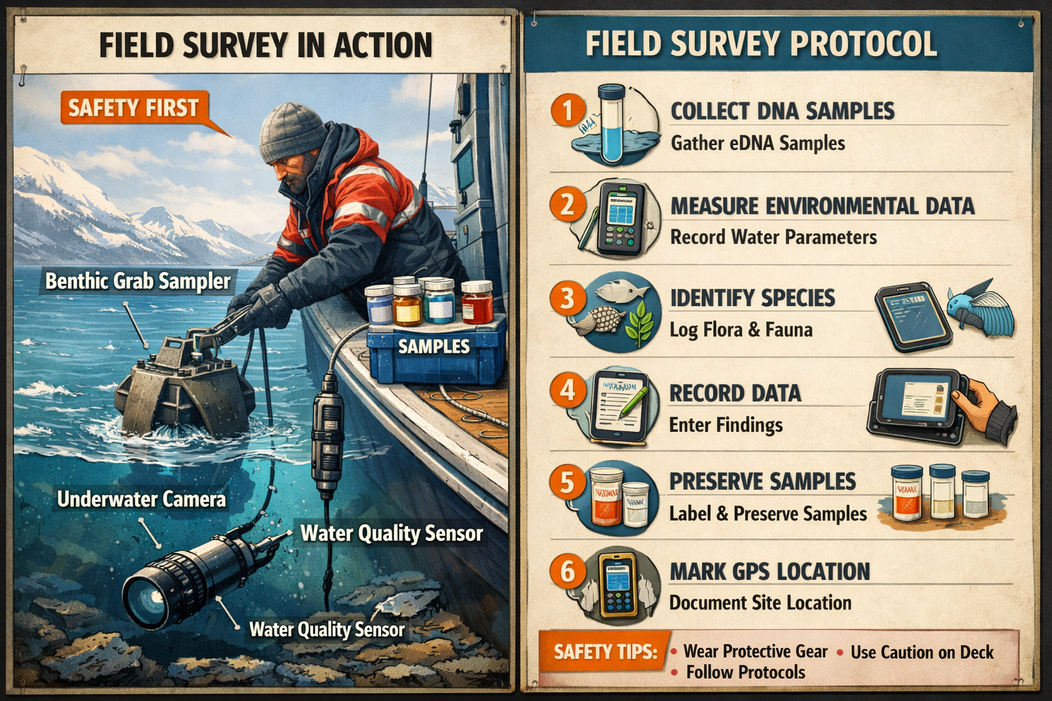
Field Collection Protocols for Genetic Samples
The genetic diversity mapping that identified Southern Ocean hotspots relied on decades of international investment in collaborative Antarctic research, with samples curated in museum infrastructure for long-term use.[1] Modern protocols build on these foundations while incorporating new technologies.
Equipment Checklist:
- 🔬 Benthic sampling gear (dredges, grabs, trawls)
- 🧪 Sterile sample containers with preservative
- 📝 Waterproof field data sheets or tablets
- 📍 GPS units for precise location recording
- 🌡️ Environmental sensors (temperature, salinity, depth)
- 📷 Underwater cameras for habitat documentation
- ❄️ Cryogenic storage for tissue preservation
Step-by-Step Collection Process:
- Navigate to sampling location using predetermined coordinates
- Record environmental data (depth, temperature, salinity, ice conditions)
- Deploy benthic sampling gear appropriate for substrate type
- Photograph habitat before disturbing the seafloor
- Retrieve sample and immediately sort organisms
- Identify specimens to lowest taxonomic level possible in field
- Collect tissue samples using sterile technique
- Preserve samples in appropriate medium (ethanol, DMSO, or flash-frozen)
- Label containers with unique identifiers, location, date, species
- Record metadata including collector, depth, coordinates, habitat notes
Quality Control Measures:
- Cross-contamination prevention through sterile technique
- Voucher specimen retention for morphological verification
- Photographic documentation of all collected specimens
- Chain of custody documentation for sample tracking
- Duplicate sampling at select locations for quality assurance
These protocols align with international best practices and ensure samples contribute to global genetic databases supporting conservation planning.
Integrating Environmental Monitoring with Biodiversity Assessment
Multi-Parameter Environmental Data Collection
Biophysical shifts in the Southern Ocean don't affect species in isolation—they reshape entire ecosystems through interconnected physical, chemical, and biological changes. Comprehensive biodiversity surveys must therefore integrate environmental monitoring to understand the context driving observed patterns.
Core Environmental Parameters:
| Parameter | Measurement Method | Relevance to Biodiversity |
|---|---|---|
| Water Temperature | CTD sensors, autonomous loggers | Metabolic rates, species distributions, phenology |
| Salinity | CTD sensors, water samples | Osmoregulation stress, habitat suitability |
| Dissolved Oxygen | Optical sensors, Winkler titration | Habitat quality, metabolic constraints |
| pH/Ocean Acidification | pH electrodes, spectrophotometry | Calcification rates, shell-building organisms |
| Nutrient Concentrations | Water sample analysis (nitrate, phosphate, silicate) | Primary productivity, food web support |
| Chlorophyll-a | Fluorometry, water samples | Phytoplankton biomass, food availability |
| Ice Coverage | Satellite imagery, visual observation | Habitat availability, light penetration |
| Current Velocity | ADCP, current meters | Larval dispersal, connectivity |
Deployment Strategies:
Environmental data collection should occur at multiple scales:
- Point measurements at each biodiversity sampling location
- Vertical profiles throughout the water column
- Continuous monitoring via moored instruments between surveys
- Remote sensing for regional context (satellite sea surface temperature, ice coverage)
This multi-scale approach connects local biodiversity patterns to regional environmental drivers, enabling ecologists to attribute observed changes to specific biophysical shifts.
Linking Genetic Diversity to Environmental Variables
One of the most powerful applications of 2026 survey protocols is identifying environmental predictors of genetic diversity. Statistical approaches can reveal which biophysical factors correlate with high genetic diversity, informing conservation prioritization.
Analytical Framework:
- Compile genetic diversity metrics for each sampling location (heterozygosity, allelic richness, nucleotide diversity)
- Extract environmental variables for corresponding locations
- Test for correlations using regression models or machine learning
- Identify environmental thresholds associated with diversity loss
- Map predicted diversity across unsampled areas based on environmental data
This approach extends the findings from the 2026 genetic hotspot study,[1] allowing ecologists to predict where additional high-diversity areas may exist and which environmental changes pose the greatest threats.
Climate Vulnerability Assessment:
By overlaying genetic diversity maps with climate change projections, ecologists can identify populations facing the greatest risk. Areas with:
- ✅ High genetic diversity + stable environmental conditions = resilience refugia
- ⚠️ High genetic diversity + rapid environmental change = priority for immediate protection
- ❌ Low genetic diversity + rapid environmental change = highest vulnerability
This vulnerability framework guides conservation triage decisions and helps focus limited resources where they can have the greatest impact—principles similar to those used in biodiversity net gain planning.
Underwater Visual Census and Photographic Documentation
While genetic sampling provides molecular insights, visual surveys capture community-level patterns and habitat characteristics that complement genetic data.
Photographic Transect Protocol:
- Deploy towed camera systems or ROVs along predetermined transects
- Capture high-resolution images at regular intervals (every 5-10 meters)
- Record depth, position, and environmental conditions for each image
- Annotate images for species presence, abundance estimates, and habitat features
- Create photomosaics for detailed habitat mapping
Benefits of Visual Documentation:
- Non-destructive sampling enables repeated surveys
- Provides habitat context for genetic samples
- Captures rare or cryptic species missed by physical sampling
- Creates permanent record for future comparison
- Enables citizen science and AI-assisted species identification
The combination of genetic, environmental, and visual data creates a comprehensive picture of Southern Ocean biodiversity and its response to biophysical shifts.
Implementing Southern Ocean Biophysical Shifts: 2026 Biodiversity Survey Protocols for Field Research
Pre-Expedition Planning and Logistics
Conducting biodiversity surveys in the Southern Ocean requires extensive preparation. The remoteness, harsh conditions, and international regulatory framework create unique logistical challenges.
Permitting and Compliance:
- Antarctic Treaty System permits for research activities
- Environmental impact assessments for proposed research (required under Protocol on Environmental Protection)
- Biosecurity protocols to prevent introduction of non-native species
- Ethics approvals for animal sampling
- International collaboration agreements when working in multiple nations' territorial waters
Vessel and Equipment Considerations:
Research in Antarctic waters typically requires ice-strengthened vessels with specialized equipment:
- Benthic sampling gear rated for deep, cold-water deployment
- Laboratory facilities for immediate sample processing
- Ultra-cold storage (-80°C freezers) for genetic samples
- Backup systems for all critical equipment
- Communication systems for remote operation
Team Composition:
Effective surveys require multidisciplinary teams:
- 🧬 Molecular ecologists for genetic sampling
- 🐙 Taxonomists for species identification
- 🌊 Physical oceanographers for environmental monitoring
- 🗺️ GIS specialists for spatial data management
- 🔧 Marine technicians for equipment operation
- 📊 Data managers for quality control
Safety Protocols:
Antarctic marine research involves significant hazards requiring comprehensive safety planning:
- Cold water survival training
- Ice navigation procedures
- Emergency evacuation plans
- Medical support capabilities
- Weather monitoring and contingency planning
These preparations ensure that Southern Ocean Biophysical Shifts: 2026 Biodiversity Survey Protocols for Ecologists Amid Accelerating Changes can be implemented safely and effectively.
Data Collection Standards and Quality Assurance
Standardized data collection ensures that surveys conducted by different teams across different years remain comparable—essential for detecting long-term trends in biodiversity.
Metadata Requirements:
Every sample and observation must include comprehensive metadata:
- Spatial data: Precise GPS coordinates, depth, geographic region
- Temporal data: Date, time, season, year
- Environmental context: Temperature, salinity, ice conditions
- Sampling details: Method, gear type, effort, collector
- Taxonomic information: Species, life stage, size
- Sample processing: Preservation method, storage conditions
- Quality flags: Data quality indicators, anomalies noted
Standardized Taxonomic Identification:
Consistent species identification across surveys requires:
- Use of accepted taxonomic authorities (World Register of Marine Species)
- Voucher specimen retention for verification
- DNA barcoding for morphologically cryptic species
- Expert consultation for difficult identifications
- Photographic documentation of all specimens
Data Entry and Validation:
- Real-time data entry minimizes transcription errors
- Automated validation checks catch impossible values
- Regular backups protect against data loss
- Version control tracks data modifications
- Metadata completeness checks before finalization
These quality assurance measures ensure survey data meets international standards and can contribute to global biodiversity databases.
Genetic Analysis Laboratory Protocols
Once samples return from the field, laboratory analysis extracts the genetic information that reveals diversity patterns and population connectivity.
DNA Extraction and Sequencing:
Modern genetic surveys typically employ one or more approaches:
- Microsatellite markers: Highly variable nuclear DNA regions for population genetics
- Mitochondrial DNA sequencing: Maternal lineages and phylogeography
- SNP genotyping: Genome-wide single nucleotide polymorphisms for high-resolution analysis
- RADseq or ddRADseq: Reduced-representation genome sequencing for non-model organisms
The choice depends on research questions, budget, and available genomic resources for target species.
Population Genetic Analyses:
Standard analyses for biodiversity assessment include:
- Genetic diversity metrics: Heterozygosity, allelic richness, nucleotide diversity
- Population structure: Clustering analyses, principal component analysis
- Connectivity estimation: Gene flow rates, migration patterns
- Effective population size: Census size vs. breeding population
- Demographic history: Population expansions, bottlenecks, refugia
These analyses reveal which populations harbor high genetic diversity (conservation priorities) and which populations are genetically connected (informing MPA network design).
Integration with Morphological Data:
Genetic data should be integrated with traditional taxonomy:
- Verify species identifications through DNA barcoding
- Detect cryptic species (morphologically similar but genetically distinct)
- Identify hybridization or introgression
- Assess genetic vs. phenotypic diversity patterns
This integrated approach provides the most complete picture of Southern Ocean biodiversity.
Conservation Applications and Biodiversity Net Gain Integration
Informing Marine Protected Area Design
The genetic hotspot mapping published in 2026 demonstrates how survey data directly informs conservation planning.[1] Ecologists conducting biodiversity surveys contribute to this process by:
Identifying Priority Conservation Areas:
- High genetic diversity zones requiring protection
- Connectivity corridors linking populations
- Unique or endemic populations
- Climate refugia with stable environmental conditions
Evaluating Existing MPA Effectiveness:
Surveys within established protected areas assess whether conservation measures achieve intended outcomes:
- Are genetic diversity levels maintained over time?
- Do protected populations serve as sources for recolonization?
- Are environmental conditions within MPAs stable or changing?
- Do species assemblages remain intact?
Designing MPA Networks:
Effective marine protection requires networks of connected reserves. Genetic connectivity data reveals:
- Which areas function as sources vs. sinks
- Optimal spacing between reserves for larval exchange
- Barriers to dispersal requiring management consideration
The finding that proposed MPAs could increase genetic hotspot protection from 28% to 54%[1] demonstrates the importance of evidence-based expansion of protected area networks—a principle that parallels biodiversity net gain strategies used in terrestrial conservation.
Biodiversity Impact Assessment for Antarctic Activities
As human activities in the Southern Ocean expand—including fishing, tourism, and research infrastructure—biodiversity impact assessments become increasingly important. The 2026 UN high seas treaty explicitly requires environmental impact assessments for activities affecting marine biodiversity.[3]
Survey protocols enable baseline characterization and impact monitoring:
Pre-Activity Baseline Surveys:
- Document existing biodiversity before activities begin
- Establish reference conditions for comparison
- Identify sensitive species or habitats requiring protection
- Assess cumulative impacts from multiple activities
Impact Monitoring:
- Detect changes in species composition or abundance
- Measure genetic diversity loss or population fragmentation
- Quantify habitat degradation
- Assess recovery trajectories after disturbance
Mitigation and Offset Design:
When impacts cannot be avoided, biodiversity survey data informs mitigation:
- Identify suitable locations for habitat restoration
- Calculate offset requirements based on biodiversity loss
- Monitor effectiveness of mitigation measures
- Adapt management based on monitoring results
These applications mirror the biodiversity impact assessment frameworks used in development contexts, adapted for the unique challenges of Antarctic marine ecosystems.
Contributing to Global Biodiversity Monitoring
Individual survey efforts gain greater value when integrated into international monitoring networks. Several initiatives coordinate Southern Ocean biodiversity data:
Southern Ocean Decade Initiative:
The Southern Ocean Decade, coordinated by the Scientific Committee on Antarctic Research (SCAR), is establishing working groups for each societal outcome, with meetings identifying community needs to address Southern Ocean priorities.[4] Ecologists conducting surveys can:
- Contribute data to centralized databases
- Participate in working groups developing standards
- Collaborate on synthesis products
- Access complementary datasets from other researchers
Global Ocean Observing System:
Antarctic biodiversity surveys feed into global ocean observation frameworks:
- Essential Ocean Variables (EOVs) for biological properties
- Essential Biodiversity Variables (EBVs) for genetic and species data[5]
- Integrated ecosystem assessments
- Climate change impact attribution
Museum and Genetic Database Contributions:
The 2026 genetic hotspot study relied on samples curated in museum collections over decades.[1] Modern surveys continue this legacy:
- Deposit voucher specimens in recognized museums
- Submit genetic sequences to GenBank and BOLD databases
- Archive environmental data in oceanographic data centers
- Document sampling metadata in biodiversity repositories
This collaborative approach ensures that Southern Ocean Biophysical Shifts: 2026 Biodiversity Survey Protocols for Ecologists Amid Accelerating Changes contribute to long-term understanding of Antarctic marine ecosystems.
Emerging Technologies and Future Directions
Environmental DNA (eDNA) Approaches
One of the most promising developments in biodiversity survey methodology is environmental DNA analysis. Rather than capturing organisms directly, eDNA techniques detect genetic material shed into the water by marine life.
Advantages for Southern Ocean Surveys:
- ✅ Non-invasive sampling minimizes ecosystem disturbance
- ✅ Detects rare or cryptic species difficult to capture
- ✅ Efficient for large spatial coverage
- ✅ Standardized water collection protocols
- ✅ Captures biodiversity across size classes (microbes to megafauna)
eDNA Protocol Overview:
- Collect water samples at multiple depths
- Filter water to capture DNA on membrane filters
- Preserve filters for laboratory analysis
- Extract DNA from filters
- Sequence using metabarcoding approaches
- Bioinformatically identify species from sequence data
- Quantify relative abundance from sequence read counts
Current Limitations:
- Species detection depends on reference database completeness
- Quantitative abundance estimates remain challenging
- DNA degradation and transport complicate source attribution
- Standardization of methods still evolving
As reference databases expand and methods mature, eDNA will increasingly complement traditional survey approaches for monitoring Southern Ocean biophysical shifts.
Autonomous and Remote Sensing Technologies
The extreme conditions and vast scale of the Southern Ocean make autonomous technologies particularly valuable for expanding survey coverage.
Autonomous Underwater Vehicles (AUVs):
- Conduct surveys beneath ice inaccessible to ships
- Deploy sensors and cameras for extended periods
- Follow pre-programmed transects with precision
- Collect environmental and biological data simultaneously
Gliders and Profiling Floats:
- Measure environmental variables across ocean basins
- Provide seasonal and inter-annual context for biodiversity patterns
- Detect oceanographic features (fronts, eddies) influencing species distributions
Satellite Remote Sensing:
- Track sea ice extent and concentration
- Measure sea surface temperature and chlorophyll
- Identify oceanographic features and productivity zones
- Provide regional context for in-situ surveys
Integration Challenges:
Combining data from multiple platforms requires:
- Temporal and spatial alignment of datasets
- Calibration and validation of remote measurements
- Statistical approaches for multi-scale integration
- Data management infrastructure for large volumes
These technologies enable more comprehensive monitoring of biodiversity responses to environmental change.
Machine Learning and Artificial Intelligence
The volume and complexity of modern biodiversity data increasingly require computational approaches for analysis.
Applications in Survey Data Analysis:
🤖 Automated Species Identification:
- Image recognition for photographic surveys
- Acoustic classification of marine mammals
- DNA sequence taxonomic assignment
🤖 Pattern Detection:
- Clustering algorithms for community classification
- Anomaly detection for identifying unusual observations
- Time series analysis for trend detection
🤖 Predictive Modeling:
- Species distribution models linking biodiversity to environment
- Genetic diversity prediction in unsampled areas
- Climate change impact forecasting
🤖 Data Quality Control:
- Automated error detection in large datasets
- Outlier identification
- Metadata completeness checking
Considerations for Implementation:
- Training data requirements for algorithm development
- Validation against expert identification
- Transparency and interpretability of model predictions
- Integration with traditional analytical approaches
As these tools mature, they will enhance the efficiency and scope of biodiversity surveys while maintaining scientific rigor.
Challenges and Solutions in Southern Ocean Survey Implementation
Logistical and Financial Constraints
Antarctic marine research faces unique challenges that require creative solutions.
Challenge: High Cost of Ship Time
Southern Ocean research vessels cost $30,000-$100,000 per day, limiting survey frequency and duration.
Solutions:
- Collaborate across institutions to share vessel costs
- Leverage tourist vessels for opportunistic sampling
- Deploy autonomous systems for continuous monitoring between ship-based surveys
- Prioritize sampling locations to maximize information gain per site
Challenge: Limited Field Season
Ice conditions restrict access to many areas to brief summer windows.
Solutions:
- Conduct year-round monitoring using autonomous instruments
- Focus summer surveys on ice-dependent habitats
- Use historical data and modeling to interpolate seasonal patterns
- Coordinate international efforts to maximize spatial coverage
Challenge: Sample Preservation in Extreme Conditions
Maintaining sample integrity during collection and transport requires specialized equipment.
Solutions:
- Use multiple preservation methods (ethanol, DMSO, flash-freezing)
- Implement redundant storage systems
- Process samples shipboard when possible
- Establish sample repositories at Antarctic research stations
Taxonomic Expertise Gaps
Identifying Southern Ocean species requires specialized knowledge, and taxonomic expertise is declining globally.
Challenge: Limited Taxonomic Specialists
Many Southern Ocean invertebrate groups lack experts for morphological identification.
Solutions:
- Invest in taxonomic training for early-career researchers
- Develop illustrated field guides and identification keys
- Employ DNA barcoding to supplement morphological identification
- Build partnerships with museum taxonomists
- Create online identification resources with image databases
Challenge: Cryptic Species Complexes
Many Antarctic species are morphologically similar but genetically distinct.
Solutions:
- Integrate molecular and morphological approaches
- Revise taxonomy based on genetic evidence
- Use DNA barcoding as primary identification tool
- Maintain voucher specimens for future re-examination
These solutions ensure that biodiversity surveys produce reliable species-level data despite taxonomic challenges.
Data Management and Accessibility
The value of biodiversity surveys depends on data being accessible for synthesis and meta-analysis.
Challenge: Data Fragmentation
Survey data often remains in individual researchers' files rather than public repositories.
Solutions:
- Mandate data sharing in research permits and funding agreements
- Provide user-friendly data submission platforms
- Recognize data publication as scholarly contribution
- Develop data standards facilitating integration across studies
Challenge: Metadata Incompleteness
Missing metadata limits data reusability.
Solutions:
- Implement mandatory metadata fields in data collection software
- Provide metadata templates and training
- Conduct quality checks before data acceptance
- Incentivize comprehensive metadata through data citation
Challenge: Long-Term Data Preservation
Ensuring data remain accessible decades into the future requires infrastructure.
Solutions:
- Deposit data in established repositories with long-term funding
- Use standardized, non-proprietary data formats
- Implement version control and change documentation
- Create data rescue initiatives for historical datasets
Addressing these data challenges ensures that survey efforts contribute to understanding Southern Ocean biophysical shifts over the long term—similar to how biodiversity net gain assessments require standardized data collection and reporting.
Case Studies: Protocols in Action
Genetic Diversity Hotspot Mapping
The 2026 SAEF study provides a compelling example of how standardized genetic surveys inform conservation.[1][8]
Methodology:
Researchers synthesized genetic data from octopus, sea spiders, and urchins collected across the Southern Ocean over multiple years. They:
- Extracted DNA from museum specimens and fresh samples
- Sequenced mitochondrial and nuclear markers
- Calculated genetic diversity metrics for each population
- Mapped diversity across the Southern Ocean
- Identified areas of high diversity, connectivity, and divergence
- Overlaid genetic patterns with existing and proposed MPAs
Key Findings:
- Clear genetic hotspots exist in specific regions
- Only 28% of hotspots currently protected
- Proposed MPA expansion would increase protection to 54%
- Connectivity corridors link populations across vast distances
- Some isolated populations show unique genetic signatures
Conservation Impact:
This research directly informs MPA network design and provides quantitative targets for protection expansion. It demonstrates how genetic survey protocols generate actionable conservation recommendations.
Lessons for Future Surveys:
- Standardized genetic markers enable data synthesis across studies
- Museum collections provide invaluable historical baselines
- Multi-species approaches reveal ecosystem-level patterns
- Integration with spatial planning maximizes conservation impact
Monitoring Climate Change Impacts on Benthic Communities
Long-term monitoring programs tracking benthic community responses to environmental change demonstrate the value of repeated surveys using consistent protocols.
Study Design:
- Established permanent monitoring sites across environmental gradients
- Conducted surveys every 2-5 years using identical methods
- Collected environmental data alongside biodiversity samples
- Analyzed trends in species composition, abundance, and diversity
Observed Changes:
- Poleward range shifts of several species
- Changes in community composition correlated with temperature
- Altered phenology (timing of reproduction, growth)
- Genetic diversity changes in some populations
Management Applications:
- Identified vulnerable species requiring protection
- Detected early warning signals of ecosystem shifts
- Informed climate adaptation strategies
- Provided empirical data for ecosystem models
This case study illustrates how Southern Ocean Biophysical Shifts: 2026 Biodiversity Survey Protocols for Ecologists Amid Accelerating Changes enable detection of climate impacts and inform adaptive management.
International Collaboration: The Southern Ocean Decade
The Southern Ocean Decade initiative, coordinated by SCAR, exemplifies how coordinated survey efforts amplify individual contributions.[4]
Collaborative Framework:
- Working groups for each societal outcome
- Standardized protocols across participating nations
- Data sharing agreements and centralized databases
- Capacity building for early-career researchers
- Integration with global ocean observing systems
Benefits of Coordination:
- Greater spatial coverage than individual programs
- Temporal consistency enabling trend detection
- Resource efficiency through shared infrastructure
- Enhanced statistical power for detecting changes
- Policy influence through unified scientific voice
Opportunities for Participation:
Ecologists can contribute to the Southern Ocean Decade by:
- Adopting standardized protocols in their research
- Sharing data through coordinated databases
- Participating in working groups
- Collaborating on synthesis publications
- Engaging in capacity building activities
This collaborative model demonstrates how individual survey efforts contribute to understanding ecosystem-scale responses to biophysical shifts.
Regulatory Framework and Compliance
Antarctic Treaty System Requirements
Research in Antarctic waters operates under the Antarctic Treaty System, which includes the Protocol on Environmental Protection to the Antarctic Treaty (Madrid Protocol).
Key Requirements:
📋 Environmental Impact Assessment:
- Preliminary assessment for all activities
- Initial Environmental Evaluation (IEE) for minor/transitory impacts
- Comprehensive Environmental Evaluation (CEE) for more than minor/transitory impacts
📋 Permit Requirements:
- Research permits from national Antarctic programs
- Special permits for taking marine organisms
- Waste management plans
- Biosecurity protocols
📋 Protected Area Regulations:
- Antarctic Specially Protected Areas (ASPAs) require specific permits
- Antarctic Specially Managed Areas (ASMAs) have management plans
- Marine Protected Areas have activity restrictions
Compliance Process:
- Prepare environmental assessment
- Submit permit applications 6-12 months before field season
- Obtain approvals from national competent authority
- Implement approved protocols
- Submit post-activity reports
Understanding these requirements ensures survey activities comply with international law.
Integration with UN High Seas Treaty
The UN treaty governing biodiversity beyond national jurisdiction, which entered force in January 2026, creates additional frameworks for Southern Ocean research.[3]
Treaty Provisions Relevant to Surveys:
🌍 Area-Based Management Tools:
- Procedures for proposing marine protected areas
- Environmental impact assessments for activities in protected areas
- Monitoring requirements for MPA effectiveness
🌍 Marine Genetic Resources:
- Benefit-sharing mechanisms for genetic discoveries
- Reporting requirements for genetic resource collection
- Intellectual property considerations
🌍 Environmental Impact Assessment:
- Screening for activities requiring assessment
- Assessment standards and procedures
- Monitoring and review requirements
Implications for Ecologists:
- Survey data may inform MPA proposals under the treaty
- Genetic sampling may trigger benefit-sharing obligations
- Research activities may require impact assessments
- Opportunities to participate in treaty implementation
As the preparatory commission finalizes operational rules throughout 2026, ecologists should stay informed about evolving requirements.
Data Sharing and Intellectual Property
Balancing open science principles with researcher rights requires clear policies.
Best Practices:
✅ Pre-Register Research Plans:
- Document survey objectives and methods before fieldwork
- Establish data sharing timelines
- Clarify authorship expectations for collaborative projects
✅ Respect Data Embargoes:
- Allow reasonable periods for data collectors to publish first analyses
- Typically 2-3 years from collection
- Make data publicly available after embargo period
✅ Acknowledge Data Sources:
- Cite datasets used in analyses
- Credit data collectors in publications
- Follow community norms for data attribution
✅ Comply with Nagoya Protocol:
- Obtain prior informed consent for genetic resource access
- Establish benefit-sharing agreements where applicable
- Document chain of custody for samples
These practices ensure ethical conduct while promoting the data sharing essential for understanding ecosystem-scale changes—principles that align with biodiversity assessment transparency in other contexts.
Training and Capacity Building
Essential Skills for Southern Ocean Ecologists
Conducting biodiversity surveys in Antarctic waters requires diverse competencies.
Technical Skills:
- 🔬 Molecular biology techniques (DNA extraction, PCR, sequencing)
- 🐙 Taxonomic identification of Southern Ocean fauna
- 🌊 Oceanographic data collection and interpretation
- 📊 Statistical analysis and modeling
- 🗺️ GIS and spatial analysis
- 🚢 Small boat operation and marine safety
- ❄️ Cold weather survival and field safety
Professional Skills:
- Project planning and logistics coordination
- Grant writing and budget management
- Scientific communication and publication
- Data management and curation
- Collaboration and teamwork
- Regulatory compliance and permitting
Training Opportunities:
Several programs provide specialized training:
- Antarctic field courses (e.g., Antarctic Circumnavigation Expedition)
- Molecular ecology workshops
- Taxonomic identification courses
- Oceanographic instrumentation training
- Data science and bioinformatics bootcamps
Investing in skill development ensures ecologists can effectively implement survey protocols.
International Collaboration and Mentorship
The collaborative nature of Antarctic research creates opportunities for knowledge exchange.
Mentorship Models:
👥 Experienced Researcher – Early Career Pairing:
- Field training during expeditions
- Laboratory technique transfer
- Career guidance and networking
- Co-authorship on publications
👥 Institutional Partnerships:
- Staff exchanges between research programs
- Shared training workshops
- Joint supervision of students
- Equipment and facility sharing
👥 South-South and North-South Collaboration:
- Capacity building in developing nations
- Technology transfer
- Funding support for participation
- Inclusive authorship practices
Building Research Networks:
Active participation in scientific communities enhances research impact:
- Attend conferences (e.g., SCAR meetings, Ocean Sciences Meeting)
- Join working groups and committees
- Contribute to community initiatives (Southern Ocean Decade)
- Engage in science communication and outreach
These connections facilitate implementation of Southern Ocean Biophysical Shifts: 2026 Biodiversity Survey Protocols for Ecologists Amid Accelerating Changes through shared expertise and resources.
Resources and Support Networks
Numerous organizations support Southern Ocean biodiversity research.
Scientific Organizations:
- Scientific Committee on Antarctic Research (SCAR) – coordinates international Antarctic science
- Southern Ocean Observing System (SOOS) – integrates ocean observations
- Commission for the Conservation of Antarctic Marine Living Resources (CCAMLR) – manages fisheries and conservation
- International Association of Antarctica Tour Operators (IAATO) – coordinates tourism research opportunities
Funding Sources:
- National Antarctic programs (NSF, NERC, AAD, etc.)
- International collaboration grants
- Early career fellowships
- Equipment and ship time allocations
Data and Information Resources:
- Antarctic Biodiversity Portal
- Ocean Biodiversity Information System (OBIS)
- GenBank and BOLD genetic databases
- SCAR data repositories
- Oceanographic data centers
Leveraging these resources enables ecologists to conduct high-quality surveys despite the challenges of Antarctic research.
Conclusion: The Path Forward for Southern Ocean Biodiversity Conservation
The Southern Ocean stands at a critical crossroads in 2026. Recognized as one of the fastest changing regions on Earth, it faces high risk of ecosystem failure without immediate protective action.[1] Yet this moment of crisis also presents unprecedented opportunity. The identification of genetic diversity hotspots across the Southern Ocean seafloor, the entry into force of the UN high seas biodiversity treaty, and the mobilization of international research collaboration through initiatives like the Southern Ocean Decade create a foundation for transformative conservation action.[1][3][4]
The Southern Ocean Biophysical Shifts: 2026 Biodiversity Survey Protocols for Ecologists Amid Accelerating Changes outlined in this guide provide a roadmap for documenting and understanding the profound transformations underway in Antarctic marine ecosystems. By implementing standardized protocols that integrate genetic sampling, environmental monitoring, and biodiversity assessment, ecologists generate the evidence base essential for informed conservation decisions.
Key Recommendations for Ecologists
🔬 Adopt Standardized Protocols
Consistency across studies enables data synthesis and long-term trend detection. Use established methods for genetic sampling, environmental data collection, and species identification. Document metadata comprehensively to maximize data reusability.
🤝 Collaborate Internationally
No single institution or nation can comprehensively monitor the Southern Ocean. Participate in coordinated initiatives like the Southern Ocean Decade, share data through established repositories, and build partnerships across borders and disciplines.
📊 Integrate Multiple Data Types
The most powerful insights emerge from combining genetic, environmental, and ecological data. Design surveys that capture multiple dimensions of biodiversity and link patterns to environmental drivers.
🌍 Engage with Policy Processes
Scientific data only influences conservation when it reaches decision-makers. Contribute to environmental impact assessments, MPA planning processes, and treaty implementation. Communicate findings to policymakers and the public.
💡 Embrace Emerging Technologies
Environmental DNA, autonomous vehicles, and machine learning offer new capabilities for biodiversity monitoring. Adopt these tools while maintaining scientific rigor and validation against traditional approaches.
The Urgency of Action
The finding that only 28% of genetic diversity hotspots currently receive protection, but that proposed MPA expansion could increase coverage to 54%,[1] illustrates both the inadequacy of current conservation and the achievable path forward. Doubling protection of these critical areas is within reach—but requires political will informed by scientific evidence.
The ecosystems with high genetic diversity identified in 2026 research are more resilient and better able to adapt to climate and environmental change.[1] Protecting these areas is not just about preserving current biodiversity—it's about safeguarding the evolutionary potential that will enable Southern Ocean ecosystems to persist through the profound environmental changes ahead.
Next Steps for Implementation
For Individual Ecologists:
- Review protocols outlined in this guide and identify which elements to incorporate into your research
- Connect with coordinating organizations (SCAR, SOOS, Southern Ocean Decade) to align your work with community priorities
- Obtain necessary permits and training before conducting fieldwork
- Commit to data sharing through established repositories
- Communicate your findings to both scientific and public audiences
For Research Institutions:
- Invest in infrastructure supporting long-term biodiversity monitoring
- Develop training programs building capacity in molecular ecology, taxonomy, and data science
- Establish data management systems ensuring long-term preservation and accessibility
- Support international collaboration through partnerships and exchange programs
- Engage with policy processes to ensure research informs conservation decisions
For Funding Agencies and Policymakers:
- Prioritize funding for standardized, long-term biodiversity monitoring
- Support synthesis activities integrating data across studies and nations
- Invest in taxonomic expertise and museum collections
- Implement the proposed MPA expansions identified through genetic hotspot mapping
- Strengthen the science-policy interface connecting research to conservation action
The Southern Ocean Biophysical Shifts: 2026 Biodiversity Survey Protocols for Ecologists Amid Accelerating Changes represent more than technical methodology—they embody a commitment to understanding and protecting one of Earth's most critical and rapidly changing ecosystems. The genetic diversity hotspots identified in 2026 research, the new international governance frameworks, and the coordinated scientific initiatives create an unprecedented window of opportunity for conservation action.
The question is not whether we have the knowledge and tools to protect Southern Ocean biodiversity—the protocols outlined here demonstrate that we do. The question is whether we will act with the urgency that the science demands. For ecologists working in these icy waters, every survey contributes to answering that question. Every genetic sample, every environmental measurement, every species observation adds to the evidence base that can drive protection of these irreplaceable ecosystems.
As the Ocean Sciences Meeting 2026 convenes in Glasgow and researchers worldwide present findings on ocean resilience and climate impacts,[2] the message is clear: the time for action is now. The Southern Ocean's biodiversity faces accelerating threats, but also unprecedented scientific attention and policy momentum. By implementing rigorous survey protocols, collaborating across borders, and engaging with conservation processes, ecologists can help ensure that the genetic diversity hotspots identified in 2026 receive the protection they need—and that Southern Ocean ecosystems retain the resilience to adapt to the changes ahead.
The protocols outlined in this guide provide the foundation. The rest depends on the collective commitment of the scientific community, policymakers, and society to act on the evidence these surveys generate. The Southern Ocean's future—and the global ocean systems it influences—hangs in the balance.
For those seeking to understand how biodiversity assessment and monitoring principles apply in other contexts, resources on biodiversity impact assessment methodologies and biodiversity net gain frameworks offer complementary perspectives on integrating conservation into human activities.
References
[1] Scientists Identify Priority Southern Ocean Genetic Hotspots For Conservation – https://arcsaef.com/news/scientists-identify-priority-southern-ocean-genetic-hotspots-for-conservation/
[2] Ocean Sciences Meeting 2026 Press Tipsheets – https://news.agu.org/press-release/ocean-sciences-meeting-2026-press-tipsheets/
[3] A New Treaty Comes Into Force To Govern Life On The High Seas – https://news.mongabay.com/2026/01/a-new-treaty-comes-into-force-to-govern-life-on-the-high-seas/
[4] sodecade – https://www.sodecade.org
[5] Developing Essential Biodiversity Variables For – https://online.ucpress.edu/elementa/article/14/1/00038/215175/Developing-Essential-Biodiversity-Variables-for?searchresult=1
[6] Ocean Sustainability Rising Tensions – https://www.sei.org/perspectives/ocean-sustainability-rising-tensions/
[7] Protecting A Changing Southern Ocean Final – https://www.asoc.org/wp-content/uploads/2025/05/Protecting-a-Changing-Southern-Ocean-FINAL.pdf
[8] 2026 02 Priority Southern Ocean Hotspots – https://phys.org/news/2026-02-priority-southern-ocean-hotspots.html
