
Only 15% of England's land area falls within designated protected areas — yet these zones can unlock disproportionately large biodiversity gains when properly integrated into Biodiversity Net Gain (BNG) site surveys. For ecology teams racing to meet 2026 compliance deadlines, understanding how to leverage existing conservation designations is no longer optional. It is a strategic advantage that can cut costs, strengthen planning applications, and deliver measurable ecological outcomes.
Protected Areas Integration in BNG Site Surveys: Ecologist Protocols for Maximizing Biodiversity Gains in 2026 Conservation Zones sits at the intersection of regulatory compliance, ecological science, and smart project planning. This guide breaks down the field protocols, legal synergies, and connectivity strategies that ecology teams need to know right now.
Key Takeaways 🌿
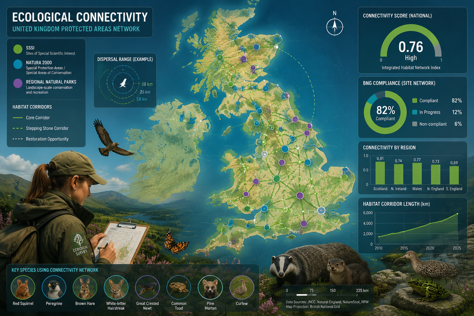
- Non-strict protected areas (Natura 2000 sites, regional natural parks) provide the majority of habitat connectivity due to their greater abundance and total area, making them critical anchors in BNG survey planning [1].
- Multilayer network analysis combining strict and non-strict protected areas dramatically boosts connectivity outcomes for multiple species — ecologists should map both types before baseline assessments begin [1].
- Species-specific dispersal differences mean mammals and birds benefit most from cross-designation connectivity, while insects, amphibians, and plants require more targeted, localised habitat interventions [1].
- Legal synergies between BNG obligations and existing protected area designations (SSSIs, SACs, SPAs) can reduce off-site delivery costs and strengthen planning applications.
- 2026 conservation zone protocols require ecologists to document connectivity pathways, not just on-site habitat units, to maximise biodiversity gain scores.
Understanding the Protected Area Landscape for BNG Compliance
Before a single quadrat is laid or a habitat condition score is recorded, ecologists need a clear picture of the protected area framework surrounding any development site. In England, this framework includes:
| Designation Type | Legal Basis | Permitted Activities | BNG Relevance |
|---|---|---|---|
| SSSI (Site of Special Scientific Interest) | Wildlife & Countryside Act 1981 | Restricted; consent required | High — baseline habitat quality multiplier |
| SAC (Special Area of Conservation) | Habitats Directive (retained) | Strictly controlled | Very High — connectivity anchor |
| SPA (Special Protection Area) | Birds Directive (retained) | Strictly controlled | Very High — bird corridor designation |
| Natura 2000 Sites | EU-derived, retained in UK law | Variable | High — non-strict PA connectivity |
| Local Nature Reserves | National Parks & Access to Countryside Act 1949 | Managed access | Medium — local corridor value |
| Green Belt / AONB | Planning Policy | Development restricted | Medium — matrix permeability |
💡 Pull Quote: "Non-strict protected areas facilitate access to high-quality habitat within strict areas, creating a strong synergy that should be leveraged in conservation design." [1]
Recent multilayer network analysis published in late 2025 confirmed that combining strict and non-strict protected areas in connectivity modelling dramatically boosts outcomes for multiple species [1]. This finding has direct implications for how ecologists structure their BNG site surveys in 2026 — the protected area network around a site is as important as the site itself.
Why Non-Strict Protected Areas Matter More Than Many Ecologists Assume
A common mistake in BNG survey planning is to focus exclusively on strict designations like SSSIs and SACs. However, research shows that non-strict protected areas — including regional natural parks and Natura 2000 sites — provide the majority of habitat connectivity because of their greater abundance and larger total area coverage [1].
For BNG purposes, this means:
- Mapping Natura 2000 sites within 2–5 km of a development boundary should be standard protocol, not an afterthought.
- Regional natural parks adjacent to a site can function as stepping-stone habitats that elevate the strategic significance of on-site habitat creation.
- Connectivity pathways through non-strict PAs can justify higher habitat condition scores in the Biodiversity Metric 4.0 calculator, particularly for the "strategic significance" multiplier.
To understand the full scope of what a BNG assessment must capture, see what is in a Biodiversity Net Gain assessment — including the habitat mapping, condition scoring, and strategic significance elements that protected area proximity directly influences.
Ecologist Field Protocols for Protected Areas Integration in BNG Site Surveys
Effective Protected Areas Integration in BNG Site Surveys: Ecologist Protocols for Maximizing Biodiversity Gains in 2026 Conservation Zones requires a structured field methodology. The following protocol framework reflects current best practice for 2026 compliance.
Step 1: Pre-Survey Desktop Review 🗺️
Before visiting the site, ecologists should complete:
- Statutory designation mapping — Use Magic Map (Natural England) to identify all SSSIs, SACs, SPAs, Ramsar sites, and Local Nature Reserves within a 5 km radius.
- Natura 2000 network review — Cross-reference with the JNCC Natura 2000 database to identify European-level connectivity obligations.
- Local Nature Recovery Strategy (LNRS) alignment — Check whether the site falls within or adjacent to a priority habitat recovery area identified in the relevant LNRS.
- Historic habitat data — Review Phase 1 and Phase 2 habitat survey records from Natural England's Designated Sites System.
- Connectivity corridor identification — Map existing green infrastructure links between the site and nearby protected areas.
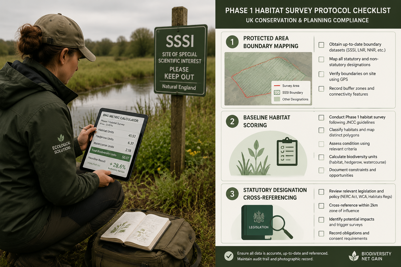
Step 2: Baseline Habitat Survey with Protected Area Context
The Phase 1 habitat survey must be conducted with explicit reference to adjacent protected area habitats. Key protocol requirements:
- Boundary zone surveys: Survey a minimum 50m buffer zone beyond the site boundary to capture habitat connectivity features (hedgerows, ditches, woodland edges).
- Condition benchmarking: Where a site adjoins a SSSI, use the SSSI's favourable condition criteria as a benchmark for on-site habitat condition scoring.
- Species-specific connectivity assessment: Record evidence of species using connectivity features (badger paths, bat foraging routes, amphibian dispersal corridors). Note that mammals and birds demonstrate higher connectivity across protection types, while insects, amphibians, reptiles, and plants show more limited connectivity due to shorter dispersal distances [1].
Step 3: Strategic Significance Assessment
The Biodiversity Metric 4.0 includes a strategic significance multiplier that can substantially increase biodiversity unit values for habitats that contribute to protected area connectivity. Ecologists should:
- Document proximity to SSSIs, SACs, and SPAs with precise measurements.
- Demonstrate functional connectivity — not just spatial proximity — using species movement data or habitat suitability modelling.
- Reference LNRS priority areas explicitly in the BNG report to justify strategic significance claims.
🔑 Key Protocol Note: The CMS CoP-15 (April 2026) reinforced that ecological connectivity is essential for conservation effectiveness, particularly for migratory species [5]. Ecologists working near flyways or migratory corridors should reference this international framework in their strategic significance arguments.
Step 4: Habitat Creation and Enhancement Design
When designing on-site habitat creation to meet the 10% BNG requirement, proximity to protected areas should directly inform habitat type selection:
- Adjacent to ancient woodland SSSI: Prioritise woodland edge habitat, veteran tree creation, and ground flora restoration.
- Adjacent to SAC wetland: Create buffer wetland, reed fringe, or wet grassland to extend the SAC's functional habitat.
- Adjacent to SPA: Design scrub and grassland mosaics that support SPA bird species during non-breeding seasons.
For guidance on how to achieve 10% Biodiversity Net Gain through strategic habitat design, the habitat type selection process is critical to maximising unit values.
Maximizing Biodiversity Gains: Connectivity Science Meets BNG Strategy
The science of habitat connectivity has evolved rapidly. The 2025 multilayer network analysis framework recommends integrating strict and non-strict protected areas with corridor design, restoration, and land management practices that increase matrix permeability [1]. In practical BNG terms, matrix permeability means making the land between protected areas more passable for wildlife.
The Synergy Effect: How Protection Types Work Together
Non-strict protected areas facilitate access to high-quality habitat within strict areas — creating a measurable synergy [1]. For BNG site surveys, this synergy can be exploited in two key ways:
🔗 Connectivity Amplification
A development site located between a Natura 2000 site (non-strict) and a SSSI (strict) sits in a connectivity corridor with high strategic value. Habitat creation on this site that bridges the two designations can attract the maximum strategic significance multiplier in Metric 4.0.
📊 Off-Site Unit Efficiency
When on-site habitat creation cannot fully meet the 10% BNG requirement, off-site units purchased near protected areas deliver greater ecological value per unit. Understanding off-site versus on-site BNG delivery is essential for cost-effective compliance.
Species-Specific Connectivity Planning
Not all species benefit equally from protected area networks. Ecologists must tailor their connectivity strategies accordingly:
| Species Group | Connectivity Benefit | Recommended Protocol |
|---|---|---|
| Mammals (badger, otter, deer) | High — wide dispersal ranges | Map landscape-scale corridors; prioritise hedgerow and riparian links |
| Birds | High — mobile, respond to habitat patches | Create scrub mosaics; reference SPA flyways |
| Insects (pollinators, beetles) | Low — short dispersal [1] | Focus on fine-scale habitat heterogeneity; wildflower strips |
| Amphibians | Low — narrow habitat requirements [1] | Pond creation within 500m of existing populations |
| Reptiles | Low — limited mobility [1] | South-facing banks, log piles, connectivity to existing reptile habitat |
| Plants | Low — seed dispersal limited [1] | Translocation protocols; reference local provenance seed sources |
The 30×30 Principle and BNG Ambition in 2026
California's 30×30 biodiversity assessment initiative — which identifies where nature is thriving, critical gaps, and opportunities for advancement — offers a useful model for how BNG site surveys can adopt a landscape-scale mindset [7]. England's own 30×30 commitments under the Global Biodiversity Framework mean that BNG sites located within or adjacent to priority conservation areas carry additional policy weight in 2026 planning decisions.
The bipartisan Habitat Connectivity on Working Lands Act, introduced in the US Senate in March 2026, similarly demonstrates the global policy direction: voluntary, incentivised connectivity improvements on private and working lands are becoming a mainstream conservation tool [2]. UK ecologists can draw on this framework when advising landowners about habitat banking opportunities adjacent to protected areas.
For landowners considering selling biodiversity units from land adjacent to protected areas, the connectivity premium represents a significant financial opportunity.
Legal Synergies, Cost Savings, and 2026 Compliance Deadlines

Protected Areas Integration in BNG Site Surveys: Ecologist Protocols for Maximizing Biodiversity Gains in 2026 Conservation Zones is not just an ecological exercise — it is a financial and legal strategy. Ecology teams that understand the legal synergies between BNG obligations and existing protected area frameworks can deliver significant cost savings for developers.
Where Legal Synergies Exist
-
SSSI Condition Improvement as BNG Credit: Natural England's conservation management agreements on SSSIs can, in some circumstances, generate biodiversity units that count toward off-site BNG delivery. Ecologists should check current Natural England guidance on this emerging area.
-
Habitats Regulations Assessment (HRA) Alignment: Development sites requiring HRA screening (due to proximity to SACs/SPAs) can align their BNG mitigation hierarchy with HRA compensatory measures, reducing duplication of ecological effort.
-
LNRS Priority Areas: Sites within LNRS priority areas may qualify for enhanced biodiversity unit values, reducing the total area of habitat creation needed to meet the 10% threshold.
-
Section 106 and Biodiversity Units: Where planning obligations already require ecological mitigation near protected areas, these can sometimes be structured to also generate BNG units, avoiding double-counting while maximising value.
Cost Savings Through Strategic Protected Area Integration
| Strategy | Potential Cost Saving | Mechanism |
|---|---|---|
| Strategic significance multiplier | 20–40% reduction in habitat area needed | Higher unit values per hectare |
| Off-site units near protected areas | 15–30% lower cost per unit | Premium habitat quality in metric |
| HRA/BNG alignment | Reduced consultant time | Single assessment process |
| LNRS priority designation | Reduced off-site purchase requirement | Enhanced on-site unit values |
For developers seeking to understand the cost of biodiversity units and statutory credits, protected area proximity is one of the most powerful — and underutilised — levers for reducing overall BNG compliance costs.
Avoiding Common Compliance Pitfalls in 2026
Ecology teams should be aware of several risks when integrating protected areas into BNG surveys:
- ⚠️ Over-claiming strategic significance without robust connectivity evidence — planners and Natural England are scrutinising these claims more carefully in 2026.
- ⚠️ Ignoring transboundary connectivity — development near national boundaries or cross-authority protected area networks requires coordination with multiple planning authorities [3].
- ⚠️ Failing to account for species-specific dispersal limits — claiming connectivity benefits for insects or amphibians without site-specific evidence is increasingly challenged at planning committees.
- ⚠️ Neglecting monitoring obligations — protected area adjacency increases the monitoring requirements in Biodiversity Management Plans, particularly for SSSI impact pathways.
Ecologists and planners can find detailed guidance on compliance requirements in 8 things you need to know about Biodiversity Net Gain as a planner, which covers the planning system interface with BNG obligations.
Conclusion: Turning Protected Area Proximity Into a BNG Asset
The integration of protected areas into BNG site surveys is one of the most powerful — and most underutilised — strategies available to ecology teams in 2026. The science is clear: combining strict and non-strict protected area networks in connectivity planning dramatically boosts biodiversity outcomes [1]. The policy direction is equally clear: from CMS CoP-15's emphasis on ecological connectivity [5] to England's 30×30 commitments, landscape-scale conservation thinking is now embedded in regulatory frameworks.
Actionable Next Steps for Ecology Teams 🎯
- Update your pre-survey desktop protocol to include mandatory multilayer protected area mapping within a 5 km radius of every BNG site.
- Train survey teams on species-specific connectivity assessment, with particular attention to the limited dispersal ranges of insects, amphibians, and reptiles [1].
- Build LNRS alignment into every BNG report to capture strategic significance multipliers where applicable.
- Engage with Natural England early on sites adjacent to SSSIs or SACs to explore legal synergies between HRA, conservation management agreements, and BNG delivery.
- Advise landowners near protected areas about the premium value of habitat banking opportunities — connectivity land commands higher biodiversity unit prices.
- Document connectivity evidence rigorously — camera trap data, bat transect records, and botanical surveys all strengthen strategic significance claims that planners and inspectors will scrutinise.
For a comprehensive overview of BNG obligations and how to structure a compliant survey programme, Biodiversity Net Gain explained provides a strong foundation for teams new to the mandatory regime.
Protected areas are not just conservation assets — in 2026, they are BNG compliance tools. Ecologists who treat them as such will deliver better outcomes for nature, stronger planning applications for developers, and more efficient use of the conservation resources that England's landscapes so urgently need.
References
[1] Synergies Between Protected Area Types Strengthen Connectivity – https://conservationcorridor.org/digests/2025/11/synergies-between-protected-area-types-strengthen-connectivity/
[2] The Habitat Connectivity On Working Lands Act Introduced In Senate – https://www.trcp.org/2026/03/26/the-habitat-connectivity-on-working-lands-act-introduced-in-senate/
[3] Environment Prelims 2026 Conventions Species Conservation Protected Areas Climate Change – https://prepairo.ai/upsc/blogs/environment-prelims-2026-conventions-species-conservation-protected-areas-climate-change/
[5] CMS CoP-15 Ecological Connectivity Strengthens Cooperation For Migratory Species – https://conservationcorridor.org/digests/2026/04/cms-cop-15-ecological-connectivity-strengthens-cooperation-for-migratory-species/
[7] Item 6 30×30 Projects 508 – https://opc.ca.gov/wp-content/uploads/2026/03/Item-6-30×30-Projects-508.pdf
