
The ocean floor, once considered too remote and challenging to exploit, has become the next frontier for industrial extraction. As 2026 unfolds, deep sea mining has emerged as one of the most pressing environmental threats facing our planet's least-explored ecosystems. With recent regulatory changes dramatically accelerating access to the seabed, biodiversity surveyors now face an urgent challenge: how to accurately assess and document the extraordinary life forms inhabiting these abyssal zones before they disappear forever. Understanding Deep Sea Mining Risks: Biodiversity Survey Techniques for Surveyors in Emerging 2026 Extraction Zones has never been more critical for professionals working to balance economic development with environmental stewardship.
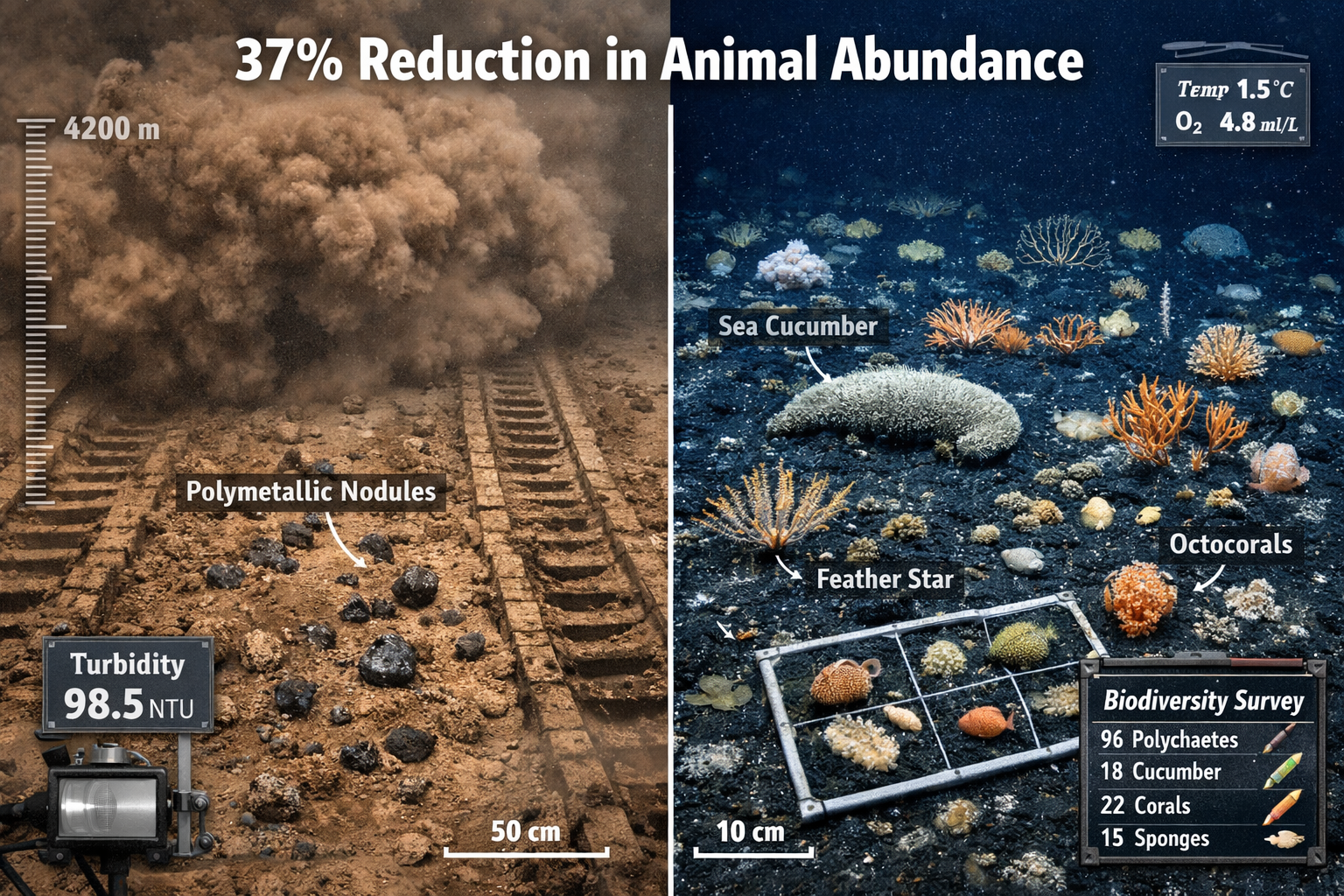
The stakes could not be higher. Recent studies have revealed that mining operations cause a 37% reduction in animal abundance and a 32% loss in species richness in directly impacted areas—devastating losses in ecosystems that took millions of years to develop.[1] Yet with 80% of the seabed still unmapped, scientists lack fundamental baseline data to understand what would be destroyed.[4] This knowledge gap presents both a challenge and an opportunity for biodiversity surveyors equipped with the right techniques and methodologies.
Key Takeaways
🔍 Regulatory Landscape Shift: NOAA's 2026 streamlined permitting rule has cut environmental assessments and public comment periods in half, dramatically accelerating commercial mining access to extraction zones.[4]
📊 Documented Ecosystem Damage: The largest impact study to date found 37% reduction in animal abundance and 32% loss in species richness within mining tracks, with effects persisting across vast areas.[1]
🧬 Advanced Survey Methodologies: Environmental DNA analysis, 3D imaging techniques, and video surveys offer non-destructive, cost-effective approaches for assessing deep-sea biodiversity in emerging extraction zones.[2]
⚠️ Critical Baseline Gap: With most seabed ecosystems undocumented and 80% unmapped, establishing comprehensive baseline data before mining begins is the most urgent priority for surveyors in 2026.[4]
🌍 Standardization Imperative: Methodological inconsistencies across surveys and absent reference catalogues currently impede organism identification—addressing this through standardized protocols is essential for meaningful impact assessment.[2]
Understanding Deep Sea Mining Risks in 2026 Extraction Zones
The Accelerated Timeline for Seabed Exploitation
The regulatory landscape governing deep sea mining underwent a seismic shift in January 2026. The National Oceanic and Atmospheric Administration (NOAA) finalized a rule that fundamentally restructured the permitting process, consolidating exploration and commercial mining applications into a single streamlined procedure.[4] This administrative change has profound implications for biodiversity surveyors working in emerging extraction zones.
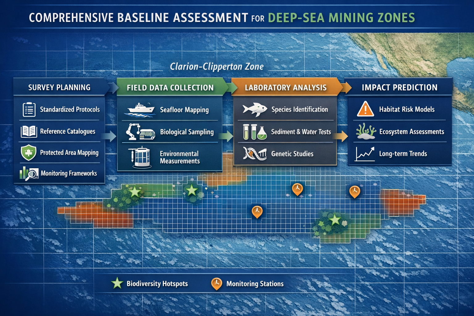
The immediate industry response demonstrated the significance of this regulatory shift. The Metals Company filed an application to mine 65,000 square kilometers of the Pacific's Clarion-Clipperton Zone—more than doubling its original request—immediately following the NOAA rule announcement.[4] This massive expansion represents an area larger than many countries and encompasses ecosystems that remain largely undocumented by science.
For surveyors, this accelerated timeline creates unprecedented pressure. The traditional model of conducting multi-year baseline studies before development has been compressed into months. Understanding how to maximize the value and accuracy of biodiversity assessments within these constrained timeframes has become a defining professional challenge for 2026.
Documented Impacts: What the Science Reveals
The most comprehensive study of deep-sea mining impacts to date provides sobering insights into the risks facing these ecosystems. Conducted over five years with more than 160 days at sea in the Pacific and three years of analytical laboratory work, this research examined the effects of a polymetallic nodule mining machine on benthic communities.[1]
Key findings include:
| Impact Category | Measurement | Result |
|---|---|---|
| Macrofaunal Abundance | Number of organisms (0.3mm-2cm) | 37% decrease in mining tracks[1] |
| Species Richness | Number of different species | 32% reduction in impacted regions[1] |
| Sediment Plume Effects | Sites ~400m from mining | No abundance change, but species dominance shifts[1] |
| Control Site Comparison | Undisturbed areas | Increased or unchanged populations[1] |
These findings reveal that Deep Sea Mining Risks: Biodiversity Survey Techniques for Surveyors in Emerging 2026 Extraction Zones must account for both direct physical disturbance and indirect sediment plume effects that can alter community composition across much wider areas than the immediate mining footprint.
The affected organisms—including polychaete worms, crustaceans, snails, and clams—represent critical components of deep-sea food webs. Their dramatic decline suggests cascading effects throughout the ecosystem that may not be immediately apparent but could fundamentally alter ecosystem function over time.
The Biodiversity Knowledge Gap
Perhaps the most concerning aspect of emerging extraction zones is how little we know about what exists there. The abyssal ecosystem harbors a "staggering array of biodiversity, much of it still undiscovered," according to experts from leading oceanographic institutions.[4] This diversity relates to largely unchanged conditions over millions of years that allowed countless species to develop and thrive in isolation.
The International Seabed Authority (ISA) has established large protected areas within the Clarion-Clipperton Zone, yet currently has "no idea, for the most part, of what lives in them."[1] This fundamental knowledge deficit means that biodiversity surveyors are not simply documenting known species populations—they are conducting discovery science while simultaneously assessing industrial impacts.
This dual mandate requires survey techniques that can:
- Rapidly characterize community composition in previously unstudied areas
- Identify new species while preserving specimens and habitat
- Establish baseline conditions against which future changes can be measured
- Detect rare or endemic species that may be particularly vulnerable to extraction
- Document ecosystem functions beyond simple species inventories
The challenge is magnified by the extreme environment itself. Working at depths of 4,000-6,000 meters, in complete darkness, under crushing pressure, with limited access windows and astronomical costs, surveyors must maximize the value of every sampling opportunity.
Biodiversity Survey Techniques for Deep Sea Mining Assessment
Environmental DNA (eDNA) Analysis: The Non-Destructive Frontier
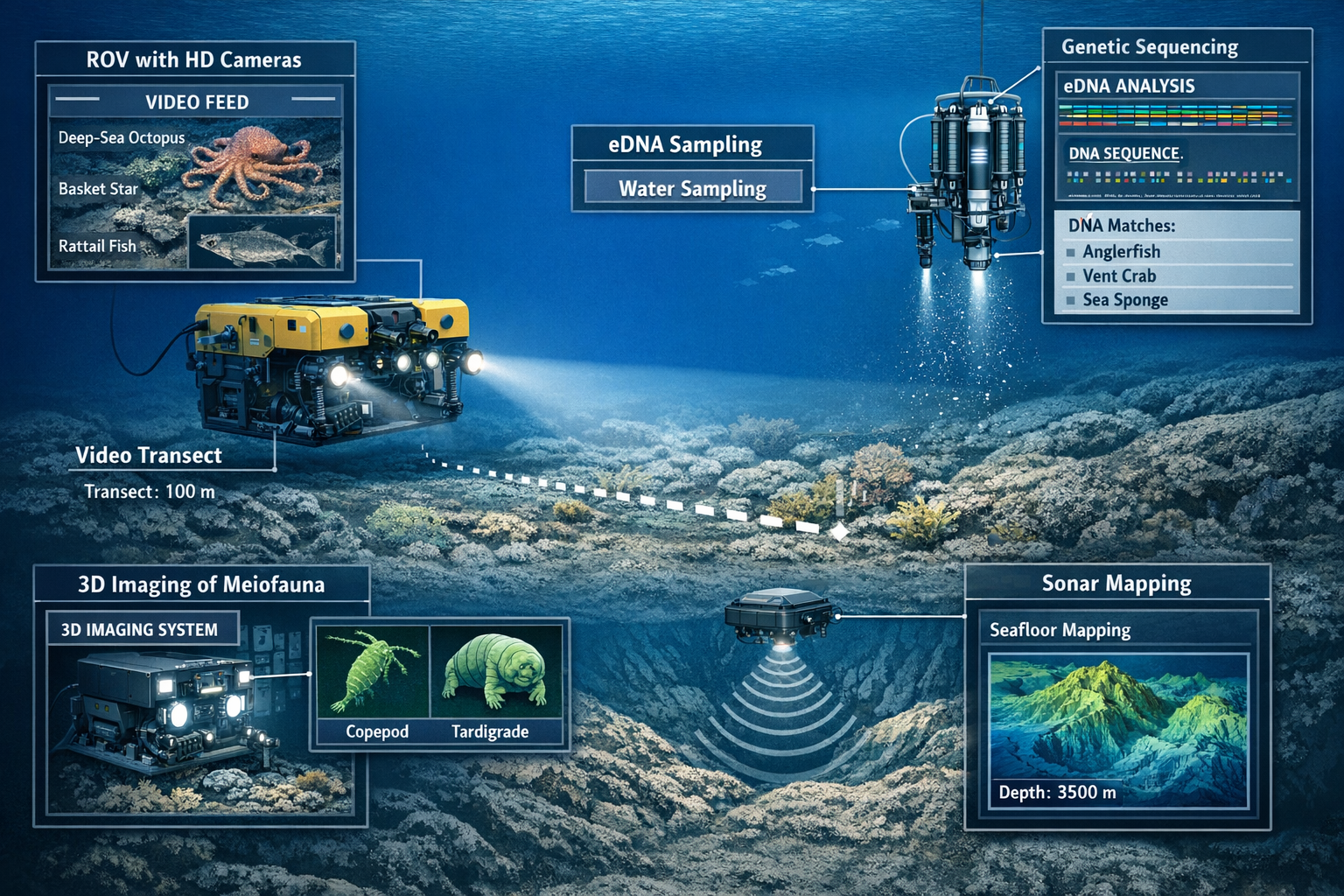
Environmental DNA analysis has emerged as one of the most promising techniques for studying marine biodiversity in deep-sea environments. This methodology detects genetic material shed by organisms into the water column, enabling species identification without physical collection or habitat disturbance.[2]
Advantages of eDNA for deep-sea mining surveys:
✅ Non-destructive sampling preserves ecosystems while gathering data
✅ Cost-effective compared to extensive physical specimen collection
✅ Easily replicable allowing standardized monitoring over time
✅ Broad taxonomic coverage detecting organisms from microbes to megafauna
✅ Temporal flexibility enabling before/during/after mining comparisons
The technique works by collecting water samples from target depths and filtering them to capture cellular material, DNA fragments, and other genetic traces. Laboratory analysis then sequences this genetic material and matches it against reference databases to identify which species are present in the area.
For surveyors implementing eDNA protocols in 2026 extraction zones, several considerations are critical:
Sample Collection Strategy: Water samples should be collected at multiple depths within the water column, as different organisms occupy different vertical niches. Bottom water samples (within 10 meters of the seafloor) capture benthic community signals, while mid-water samples detect pelagic organisms. Sampling both upstream and downstream of proposed mining sites enables detection of plume transport effects.
Reference Database Limitations: The effectiveness of eDNA analysis depends entirely on the completeness of genetic reference libraries. For deep-sea organisms, these databases remain woefully incomplete. Surveyors should plan for "unknown" sequences and integrate eDNA with physical specimen collection to build reference catalogues for future use.
Temporal Considerations: eDNA degrades over time in seawater, with persistence varying by organism type, water temperature, and other factors. This temporal signature can be useful—recent presence produces stronger signals than historical presence—but requires careful interpretation in slow-moving deep-sea environments.
The ISA's Sustainable Seabed Knowledge Initiative (SSKI), launched in 2022, serves as a coordinated global effort to increase the availability and accessibility of scientific information on deep-sea ecosystems, with eDNA methodologies playing a central role.[2] Surveyors working in emerging extraction zones should align their protocols with SSKI standards to ensure data compatibility and contribute to this growing knowledge base.
Video Survey and ROV-Based Visual Assessment
Remotely Operated Vehicles (ROVs) equipped with high-definition cameras provide direct visual documentation of deep-sea communities and habitat characteristics. Video surveys offer unique advantages for Deep Sea Mining Risks: Biodiversity Survey Techniques for Surveyors in Emerging 2026 Extraction Zones assessment that complement molecular and physical sampling approaches.[2]
Key capabilities of video survey techniques:
🎥 Spatial Context: Video captures organism distribution patterns, habitat associations, and community structure in ways that individual specimens cannot convey
🎥 Behavioral Observations: Live footage documents feeding behaviors, predator-prey interactions, and other ecological processes
🎥 Megafauna Detection: Large, mobile organisms often missed by sediment sampling are readily observed on video
🎥 Habitat Characterization: Seafloor topography, nodule density, sediment type, and other physical features are documented alongside biological communities
🎥 Permanent Record: Video archives enable future re-analysis as identification capabilities improve and new questions emerge
Modern ROV systems can conduct systematic transect surveys, following predetermined paths across the seafloor while maintaining consistent altitude and camera angles. This standardization enables quantitative analysis of organism density, size distributions, and spatial patterns.
Best practices for ROV video surveys in mining zones:
-
Transect Design: Establish a grid pattern covering representative habitats within the proposed mining area, with transects extending into adjacent reference areas for comparison
-
Standardized Protocols: Maintain consistent altitude (typically 2-3 meters above bottom), camera angles, lighting, and speed (0.2-0.5 knots) to enable quantitative comparisons
-
Annotation Systems: Use standardized terminology and measurement protocols when documenting organisms and features, following ISA guidelines
-
Complementary Still Photography: Capture high-resolution still images at regular intervals for detailed morphological analysis
-
Laser Scaling: Deploy parallel laser pointers in camera field of view to enable accurate size measurements of organisms and features
The integration of video data with other survey techniques creates powerful synergies. For example, when eDNA samples are collected at the same locations as video transects, genetic detections can be correlated with visual observations to validate identifications and understand which organisms contribute to the eDNA signal.
Similar to how biodiversity impact assessments require comprehensive baseline documentation in terrestrial environments, deep-sea video surveys establish the visual baseline against which mining impacts can be measured.
Three-Dimensional Imaging for Meiofauna Identification
Meiofauna—microscopic organisms ranging from 0.063mm to 0.5mm—represent a critical but challenging component of deep-sea biodiversity. These tiny organisms often dominate benthic communities in terms of abundance and species richness, yet their small size and morphological complexity make identification extremely difficult using traditional microscopy.
The Ifremer Blue Revolution project has pioneered the development and testing of 3D imaging techniques specifically designed to identify meiofauna organisms in deep-sea ecosystems currently being explored for mineral resources.[2] This technological advancement addresses a major gap in biodiversity survey capabilities.
How 3D imaging enhances meiofauna assessment:
-
Volumetric Analysis: Three-dimensional reconstructions capture morphological details from multiple angles, revealing diagnostic features not visible in two-dimensional images
-
Non-Destructive Examination: Specimens can be thoroughly documented before any destructive sampling for molecular analysis
-
Digital Reference Collections: 3D models create permanent, shareable reference materials that can be examined by taxonomists worldwide
-
Indicator Species Identification: The technique focuses on identifying key indicator species that signal environmental changes, enabling more efficient monitoring
-
Machine Learning Integration: 3D datasets can train artificial intelligence systems for automated identification, dramatically increasing processing capacity
For surveyors implementing 3D imaging in 2026 extraction zones, the technology remains specialized and requires significant expertise. However, as the methodology matures and becomes more accessible, it promises to revolutionize our understanding of deep-sea meiofaunal communities—the very organisms most likely to be affected by sediment disturbance from mining operations.
The focus on indicator species is particularly valuable for practical impact assessment. Rather than attempting to identify every organism in a sample (an often impossible task given the number of undescribed species), surveyors can focus on species known to be sensitive to disturbance or representative of particular environmental conditions. Changes in these indicator populations provide early warning signals of ecosystem degradation.
Physical Sampling: Box Cores, Multicores, and Specimen Collection
Despite advances in non-destructive techniques, physical sampling remains essential for comprehensive biodiversity assessment. Sediment samples collected using box corers and multicorers provide quantitative data on organism abundance, biomass, and community composition that cannot be obtained through other methods.
Box Corers collect large sediment samples (typically 0.25-1 square meter surface area, 30-50cm depth) that preserve the sediment-water interface and vertical stratification. These samples enable:
- Quantitative macrofaunal analysis (organisms >0.5mm)
- Meiofaunal abundance and diversity assessment
- Sediment geochemistry and grain size characterization
- Microbial community analysis
- Vertical distribution patterns within the sediment
Multicorers collect multiple smaller sediment cores simultaneously (typically 8-12 cores of 10cm diameter), offering:
- Better replication for statistical analysis
- Less disturbance to sediment structure
- Easier processing for specific analyses
- Ability to preserve cores for different analytical purposes
Survey design considerations for physical sampling:
📍 Spatial Coverage: Samples should be distributed across environmental gradients (depth, nodule density, topography) to capture habitat heterogeneity
📍 Replication: Multiple samples at each location enable statistical assessment of natural variability versus mining impacts
📍 Temporal Baseline: Repeat sampling over seasons and years establishes natural temporal variation patterns
📍 Control Sites: Samples from areas beyond mining influence provide reference conditions for impact comparison
📍 Preservation Methods: Different organisms and analyses require different preservation (frozen, formalin, ethanol, live sorting) necessitating sample splitting protocols
The five-year study that documented the 37% reduction in macrofaunal abundance relied heavily on physical sampling to generate quantitative impact data.[1] This research demonstrates that while non-destructive techniques provide valuable information, physical samples remain the gold standard for measuring population-level changes.
Surveyors should integrate physical sampling with eDNA and video surveys to create complementary datasets. For example, organisms identified in video surveys can be targeted for collection to enable detailed taxonomic work and genetic reference sequence generation. Similarly, eDNA detections of rare species can guide targeted sampling efforts.
Just as achieving biodiversity net gain in terrestrial environments requires careful baseline assessment and monitoring, deep-sea mining impact evaluation depends on rigorous physical sampling protocols that can detect and quantify changes in benthic communities.
Acoustic and Sonar Mapping Technologies
Understanding the physical structure of the seafloor provides essential context for biological surveys and mining impact assessment. Modern acoustic technologies enable detailed mapping of bathymetry, substrate characteristics, and even some biological features at scales ranging from centimeters to kilometers.
Multibeam Sonar Systems create high-resolution three-dimensional maps of seafloor topography, revealing:
- Bathymetric features (ridges, valleys, seamounts, abyssal plains)
- Substrate hardness and composition through backscatter analysis
- Nodule fields and distribution patterns
- Potential habitat complexity and heterogeneity
Side-Scan Sonar provides photographic-like images of the seafloor surface, detecting:
- Texture variations indicating different sediment types
- Large biological features (sponge gardens, coral colonies)
- Anthropogenic impacts (mining tracks, equipment)
- Geological features at high resolution
Sub-Bottom Profilers penetrate sediment to reveal:
- Sediment layer thickness and structure
- Buried geological features
- Potential bioturbation zones
- Historical disturbance events
For biodiversity surveyors, acoustic mapping serves multiple critical functions. First, it enables stratified sampling design by identifying distinct habitat types that should be sampled separately. Second, it provides spatial context for understanding organism distribution patterns and environmental drivers. Third, it establishes baseline conditions for detecting physical changes caused by mining operations.
The integration of acoustic data with biological surveys creates powerful predictive models. By correlating organism distributions with physical habitat characteristics, surveyors can extrapolate from sampled locations to make inferences about unsampled areas—a critical capability when comprehensive sampling of vast mining zones is logistically impossible.
Implementing Standardized Protocols for Deep Sea Mining Risks Assessment
The Standardization Challenge
One of the most significant obstacles facing biodiversity surveyors working in emerging extraction zones is the lack of standardized methodologies. Significant methodological inconsistency exists across surveys, and comprehensive reference catalogues are absent, which impedes organism identification and genetic sequence matching.[2] This standardization gap creates serious problems for impact assessment.
Consequences of methodological inconsistency:
❌ Data Incomparability: Results from different surveys cannot be directly compared or combined
❌ Temporal Discontinuity: Baseline and post-impact surveys using different methods may show differences due to methodology rather than actual changes
❌ Regulatory Uncertainty: Inconsistent data quality makes it difficult to establish meaningful environmental standards
❌ Resource Inefficiency: Lack of standardization prevents leveraging of existing data and requires redundant sampling
❌ Identification Barriers: Without reference catalogues using consistent taxonomy, organism identification remains subjective and inconsistent
The ISA has recognized this critical limitation and is addressing it through standardization workshops and the development of recommended protocols.[2] For surveyors working in 2026 extraction zones, alignment with these emerging standards is essential for producing data that will be scientifically credible and regulatory compliant.
Developing Comprehensive Baseline Assessments
The foundation of effective impact assessment is a thorough baseline characterization conducted before mining activities begin. With the accelerated permitting timeline in 2026, establishing adequate baselines has become more challenging yet more critical than ever.
Essential components of comprehensive baseline assessments:
-
Multi-Season Sampling: Deep-sea ecosystems exhibit temporal variability in productivity, reproduction, and community composition. Baseline surveys should span multiple seasons and ideally multiple years to capture this natural variation.
-
Spatial Replication: Sufficient sampling across the mining zone and reference areas enables statistical power to detect changes and distinguish mining impacts from natural spatial heterogeneity.
-
Taxonomic Breadth: Assessments should cover all major organism groups (microbes, meiofauna, macrofauna, megafauna) as different taxa may respond differently to disturbance.
-
Functional Characterization: Beyond species lists, baselines should document ecosystem functions such as bioturbation rates, organic matter processing, nutrient cycling, and trophic relationships.
-
Physical-Biological Integration: Concurrent measurement of physical parameters (temperature, oxygen, currents, sediment chemistry) enables understanding of environmental drivers and prediction of mining effects.
-
Rare Species Detection: Sufficient sampling effort to detect rare, endemic, or potentially vulnerable species that may be present at low densities.
The challenge for surveyors is accomplishing these comprehensive objectives within the compressed timelines now imposed by streamlined permitting. This requires strategic survey design that maximizes information gain per sampling effort and leverages the most efficient techniques for each assessment objective.
Similar to how biodiversity net gain assessments require systematic baseline documentation in terrestrial development, deep-sea mining baseline surveys must follow rigorous protocols to ensure defensible impact evaluation.
Quality Assurance and Data Management
The extreme cost and logistical complexity of deep-sea surveys means that data quality and proper management are paramount. Lost or corrupted data from a deep-sea expedition cannot be easily replaced, and poor quality control can invalidate months of expensive fieldwork.
Critical quality assurance measures:
🔬 Field Protocols: Detailed standard operating procedures for sample collection, preservation, labeling, and storage
🔬 Chain of Custody: Clear documentation tracking samples from collection through analysis
🔬 Taxonomic Verification: Multiple expert reviews of organism identifications, with voucher specimens archived in recognized institutions
🔬 Genetic Sequence Validation: Quality filtering of eDNA sequences and submission to public databases (GenBank, BOLD)
🔬 Metadata Standards: Comprehensive documentation of sampling methods, locations, dates, equipment, and environmental conditions
🔬 Data Archiving: Long-term storage in accessible repositories with appropriate metadata for future use
The ISA's Sustainable Seabed Knowledge Initiative provides frameworks for data sharing and standardization that surveyors should utilize.[2] Contributing data to these centralized resources not only ensures proper archiving but also enables comparative analyses across mining zones and time periods.
For organizations conducting surveys in 2026 extraction zones, investment in robust data management systems and quality assurance protocols is not optional—it is fundamental to producing credible, defensible assessments that can withstand scientific and regulatory scrutiny.
Integration with Impact Prediction Models
Baseline survey data becomes most valuable when integrated into predictive models that forecast mining impacts. These models combine physical disturbance predictions (mining footprint, sediment plume transport) with biological sensitivity data to estimate ecosystem consequences.
Key modeling approaches:
-
Species Distribution Models: Predict organism occurrence based on environmental variables, enabling extrapolation beyond sampled locations
-
Sediment Plume Dispersion Models: Simulate the transport and deposition of mining-generated sediment to predict spatial extent of impacts
-
Population Viability Analysis: Assess whether remaining populations outside mining zones can sustain species persistence
-
Ecosystem Function Models: Predict changes in biogeochemical processes and ecosystem services resulting from community alterations
-
Recovery Trajectory Models: Estimate timescales for ecosystem recovery based on organism life histories and recruitment patterns
The documented 37% reduction in abundance and 32% loss in species richness from mining trials provides critical calibration data for these models.[1] As more impact studies are completed, model accuracy will improve, enabling better prediction of consequences in new extraction zones.
Surveyors should design baseline assessments with modeling requirements in mind, ensuring that data collected includes the environmental variables and biological parameters needed for model development and validation. This forward-thinking approach maximizes the value of baseline investments.
Risk Mitigation Strategies and Adaptive Management
Establishing Protected Reference Areas
One of the most important risk mitigation strategies for deep-sea mining is the establishment of protected reference areas that remain free from extraction activities. These areas serve multiple critical functions for biodiversity conservation and impact assessment.
Functions of protected reference areas:
🛡️ Biodiversity Refugia: Preserve populations that can potentially recolonize disturbed areas
🛡️ Baseline Continuity: Provide ongoing reference conditions for detecting mining impacts
🛡️ Natural Variability Assessment: Enable distinction between mining effects and natural temporal changes
🛡️ Recovery Monitoring: Serve as targets for restoration efforts and recovery trajectory comparison
🛡️ Unknown Species Protection: Safeguard undiscovered biodiversity from extinction
The ISA has established protected areas within the Clarion-Clipperton Zone, though the adequacy of these reserves remains debated given the limited knowledge of what lives in them.[1] For surveyors working with mining companies or regulatory agencies, advocating for scientifically designed protected area networks is an important professional responsibility.
Design criteria for effective protected areas:
- Representativeness: Include all major habitat types present in the mining zone
- Connectivity: Enable larval dispersal and genetic exchange between protected areas
- Size: Sufficient area to support viable populations of species with large home ranges
- Replication: Multiple protected areas to guard against catastrophic loss from single events
- Proximity: Close enough to mining zones to serve as recolonization sources but far enough to avoid plume impacts
Biodiversity surveys play a crucial role in protected area design by identifying biodiversity hotspots, rare species locations, and habitat heterogeneity that should be represented in reserve networks.
Adaptive Management and Monitoring Frameworks
Given the enormous uncertainties surrounding deep-sea mining impacts, adaptive management approaches are essential. These frameworks use ongoing monitoring to detect actual impacts and adjust operations to minimize harm.
Key elements of adaptive management:
-
Impact Hypotheses: Explicit predictions about expected changes based on baseline data and models
-
Monitoring Indicators: Specific, measurable parameters that signal ecosystem changes
-
Trigger Thresholds: Pre-defined levels of change that trigger management responses
-
Response Protocols: Predetermined actions when thresholds are exceeded (operational modifications, temporary cessation, etc.)
-
Learning Integration: Systematic incorporation of monitoring results into updated impact predictions and management strategies
For surveyors, this creates ongoing work opportunities beyond initial baseline assessment. Monitoring programs require repeated surveys using consistent methodologies to detect changes over time. The standardized protocols discussed earlier become particularly important in this context—methodological changes between baseline and monitoring surveys can create apparent changes that reflect technique rather than actual impacts.
The sediment plume effects documented in mining trials—showing no abundance change but shifts in species dominance patterns at sites 400 meters from mining operations[1]—illustrate the kind of subtle but significant changes that monitoring programs must be designed to detect.
Just as benefitting nature and developers requires ongoing collaboration and adaptive approaches in terrestrial development, deep-sea mining impact mitigation depends on continuous monitoring and responsive management.
Technology Development and Innovation
The rapid evolution of survey technologies creates both opportunities and challenges for surveyors working in emerging extraction zones. Staying current with technological developments and contributing to innovation in survey methodologies is increasingly important for professional practice.
Emerging technologies with high potential:
🚀 Autonomous Underwater Vehicles (AUVs): Untethered robots that can conduct extended surveys without ship support, dramatically reducing costs
🚀 Artificial Intelligence Image Analysis: Machine learning systems that can process video and still images to identify and count organisms automatically
🚀 In Situ Genetic Sequencing: Portable DNA sequencing devices that can identify organisms in real-time during surveys
🚀 Passive Acoustic Monitoring: Recording devices that detect sounds produced by organisms, revealing presence and behavior
🚀 Chemical Sensor Arrays: Instruments that detect organism-produced chemical signals in water, complementing eDNA approaches
🚀 Holographic Imaging: Three-dimensional imaging of small organisms in situ without collection
For surveying organizations, investment in these emerging technologies can provide competitive advantages and enable more comprehensive assessments. However, the adoption of new techniques must be balanced against the need for consistency with historical data and standardized protocols.
Professional development for surveyors should include training in new technologies and methodologies as they become available. The field is evolving rapidly, and practitioners who fail to keep pace risk obsolescence.
Regulatory Compliance and Professional Standards
Understanding the 2026 Regulatory Environment
The January 2026 NOAA rule fundamentally altered the regulatory landscape for deep-sea mining in areas beyond national jurisdiction. The consolidation of exploration and commercial mining applications into a single streamlined process has significant implications for biodiversity survey requirements.[4][5]
Key regulatory changes surveyors must understand:
-
Compressed Timelines: Environmental assessments and public comment periods have been cut in half, reducing time available for baseline surveys
-
Integrated Applications: Exploration and commercial extraction are now considered together, requiring surveys to address both phases
-
Reduced Oversight: Fewer regulatory checkpoints mean less opportunity for adaptive management based on new information
-
Industry Access: Lower barriers to permitting have accelerated commercial interest and application submissions
For surveyors, these changes create pressure to deliver comprehensive assessments more quickly while maintaining scientific rigor. Understanding the specific data requirements of regulatory applications is essential for efficient survey design.
The Federal Register documentation of the NOAA rule provides detailed requirements for environmental impact assessments accompanying mining applications.[5] Surveyors should thoroughly review these requirements to ensure that baseline assessments address all mandatory elements.
Professional Certification and Competency Standards
As deep-sea mining transitions from experimental to commercial scale, the need for professional standards and certification for biodiversity surveyors becomes increasingly apparent. Unlike terrestrial surveying disciplines that have well-established professional organizations and certification programs, deep-sea survey standards remain underdeveloped.
Competency areas for deep-sea biodiversity surveyors:
✓ Taxonomic Expertise: Ability to identify deep-sea organisms or coordinate with appropriate specialists
✓ Sampling Methodology: Proficiency with physical, molecular, and visual survey techniques
✓ Statistical Design: Capability to design surveys with adequate statistical power and spatial coverage
✓ Data Management: Skills in data quality assurance, archiving, and sharing
✓ Impact Assessment: Understanding of mining operations and their potential ecosystem effects
✓ Regulatory Knowledge: Familiarity with applicable regulations and permitting requirements
Professional organizations such as the Deep Ocean Stewardship Initiative and the International Seabed Authority are working to develop standards and best practices. Surveyors should engage with these efforts and pursue relevant training and certification as programs become available.
For organizations hiring surveyors for deep-sea mining projects, verification of competency across these domains is essential. The extreme cost of deep-sea operations means that inadequate surveys can result in massive financial losses and regulatory complications.
Ethical Considerations and Conflicts of Interest
Biodiversity surveyors working in the deep-sea mining sector face complex ethical considerations. Many surveys are funded by mining companies seeking permits, creating potential conflicts of interest that must be carefully managed.
Ethical principles for surveyors:
-
Scientific Integrity: Commitment to accurate, unbiased data collection and reporting regardless of client preferences
-
Transparency: Clear disclosure of funding sources and potential conflicts
-
Precautionary Approach: When uncertainties exist, recommendations should favor ecosystem protection
-
Public Interest: Recognition that deep-sea ecosystems are global commons requiring stewardship beyond client interests
-
Professional Independence: Maintenance of scientific judgment independent of commercial pressures
Professional organizations and regulatory agencies should develop codes of conduct specific to deep-sea mining surveys that address these ethical dimensions. Individual surveyors must cultivate the professional courage to deliver unwelcome findings when data indicate significant risks.
The documented ecosystem damages from mining trials[1] and the vast knowledge gaps that remain[4] suggest that many proposed mining operations may pose unacceptable risks to biodiversity. Surveyors have a professional obligation to clearly communicate these risks even when doing so may conflict with client objectives.
Future Directions and Emerging Challenges
Climate Change Interactions
Deep-sea ecosystems are not static—they are already experiencing changes driven by climate change, including warming, deoxygenation, and acidification. These ongoing environmental shifts interact with mining impacts in ways that are poorly understood but potentially significant.
Climate-mining interaction considerations:
🌡️ Cumulative Stress: Organisms already stressed by changing environmental conditions may be less resilient to mining disturbance
🌡️ Shifting Baselines: Climate-driven changes may alter community composition during baseline studies, complicating impact detection
🌡️ Recovery Impediments: Changing environmental conditions may prevent recovery to pre-mining states even if mining ceases
🌡️ Range Shifts: Species distributions may change over time, affecting the representativeness of protected areas
🌡️ Synergistic Effects: Combined climate and mining stressors may produce impacts greater than either alone
Surveyors must consider these interactions when designing baseline assessments and interpreting monitoring data. Environmental parameters that indicate climate change effects (temperature, oxygen, pH) should be measured alongside biological variables to enable detection of interaction effects.
The long timescales of deep-sea ecosystem processes—with some organisms living for centuries and recovery potentially requiring millennia—mean that mining decisions made in 2026 will have consequences extending far into the future, compounding with ongoing climate changes.
Expanding Extraction Zones and Cumulative Impacts
The Metals Company's application to mine 65,000 square kilometers represents just the beginning.[4] As mining becomes economically viable and regulatory barriers decrease, extraction zones will expand across vast areas of the deep ocean floor. This spatial expansion creates cumulative impact challenges that individual project assessments cannot address.
Cumulative impact considerations:
-
Connectivity Disruption: Mining across large areas may fragment populations and disrupt larval dispersal networks
-
Ecosystem-Scale Changes: Widespread extraction could alter biogeochemical processes at regional or even ocean-basin scales
-
Plume Overlap: Sediment plumes from multiple operations may combine to affect much larger areas than individual projects
-
Reference Area Adequacy: As mining expands, finding truly unimpacted reference areas becomes increasingly difficult
-
Synergistic Stressors: Multiple mining operations plus climate change plus other human impacts create complex stress combinations
Biodiversity surveyors must begin thinking beyond individual project scales to consider ecosystem-level and ocean-basin-level impacts. This requires coordination across projects, data sharing, and development of regional monitoring networks.
The ISA's Sustainable Seabed Knowledge Initiative provides a framework for this kind of coordinated approach,[2] but implementation remains in early stages. Surveyors can contribute by ensuring their data is compatible with regional databases and participating in collaborative research efforts.
Technological Solutions and Alternatives
While much attention focuses on assessing and mitigating mining impacts, parallel efforts are exploring technological alternatives that could reduce or eliminate the need for deep-sea extraction.
Alternatives to deep-sea mining:
- Enhanced Recycling: Improved recovery of metals from electronic waste and other sources
- Material Substitution: Development of technologies using more abundant materials
- Terrestrial Mining Innovation: Techniques to extract metals from lower-grade ores or previously uneconomic deposits
- Circular Economy Models: Design approaches that minimize virgin material requirements
For biodiversity surveyors, awareness of these alternatives provides important context. If surveys reveal that mining poses unacceptable biodiversity risks, supporting development of alternatives becomes an important professional contribution.
The precautionary principle suggests that when activities pose threats of serious or irreversible damage to ecosystems we barely understand, the burden of proof should fall on those proposing the activity to demonstrate safety. Comprehensive biodiversity surveys that reveal the extraordinary complexity and vulnerability of deep-sea ecosystems strengthen the case for pursuing alternatives.
Conclusion: Charting a Responsible Path Forward
The emergence of commercial deep-sea mining in 2026 represents one of the most significant environmental challenges of our time. With regulatory barriers lowered and industry applications accelerating, the window for establishing comprehensive baseline data and effective impact assessment frameworks is rapidly closing. Understanding Deep Sea Mining Risks: Biodiversity Survey Techniques for Surveyors in Emerging 2026 Extraction Zones has evolved from an academic exercise to an urgent professional imperative.
The science is clear: deep-sea mining causes substantial biodiversity losses, with documented reductions of 37% in animal abundance and 32% in species richness in impacted areas.[1] These losses occur in ecosystems that harbor extraordinary biodiversity, much of it still undiscovered, that has developed over millions of years in stable conditions.[4] Recovery, if possible at all, will likely require timescales measured in centuries or millennia.
Yet the knowledge gaps remain vast. With 80% of the seabed unmapped and most deep-sea organisms unknown to science, we are making irreversible decisions about ecosystems we barely understand.[4] This fundamental uncertainty demands that biodiversity surveyors bring the highest standards of scientific rigor and professional integrity to their work.
Actionable Next Steps for Surveyors
For Individual Practitioners:
-
Enhance Technical Skills: Pursue training in eDNA analysis, video survey techniques, and emerging technologies for deep-sea biodiversity assessment
-
Engage with Standards Development: Participate in ISA workshops and professional organizations working to establish standardized protocols[2]
-
Build Taxonomic Networks: Develop relationships with deep-sea taxonomic specialists who can support organism identification
-
Advocate for Adequate Timelines: Push back against unrealistic survey schedules that compromise data quality
-
Maintain Professional Independence: Commit to reporting findings accurately regardless of client preferences
For Survey Organizations:
-
Invest in Technology: Acquire or partner for access to ROVs, eDNA analysis capabilities, and advanced imaging systems
-
Develop Quality Systems: Implement robust data management, quality assurance, and archiving protocols
-
Collaborate Internationally: Join consortia and data-sharing initiatives to contribute to and benefit from global knowledge development
-
Support Research: Allocate resources to methods development and validation studies that advance survey capabilities
-
Engage Ethically: Establish clear policies on conflicts of interest and scientific independence
For Regulatory Agencies:
-
Require Comprehensive Baselines: Mandate multi-year, multi-season baseline assessments before permitting mining operations
-
Enforce Standardization: Require adherence to ISA protocols and data standards for all surveys
-
Establish Protected Areas: Designate scientifically designed reserve networks before authorizing commercial extraction
-
Mandate Adaptive Management: Require ongoing monitoring with predetermined trigger thresholds and response protocols
-
Support Knowledge Development: Fund independent research on deep-sea ecosystems and mining impacts
The path forward requires balancing legitimate interests in accessing mineral resources with equally legitimate imperatives to protect irreplaceable ecosystems and preserve options for future generations. Biodiversity surveyors occupy a critical position in this balance, providing the scientific foundation upon which informed decisions can be made.
The techniques and approaches outlined in this guide—from eDNA analysis and video surveys to 3D imaging and physical sampling—provide powerful tools for characterizing deep-sea biodiversity and assessing mining risks. When implemented with appropriate rigor, standardization, and professional integrity, these methods can reveal what exists in emerging extraction zones and what would be lost to mining operations.
Yet tools alone are insufficient. The professional community must commit to using these tools in service of genuine understanding rather than regulatory compliance checkbox-checking. The extraordinary biodiversity of the deep sea, developed over millions of years in Earth's largest ecosystem, deserves nothing less than our most rigorous science and most careful stewardship.
As 2026 unfolds and commercial deep-sea mining transitions from possibility to reality, the work of biodiversity surveyors will help determine whether this new frontier is developed responsibly or recklessly. The decisions made now, based on the surveys conducted today, will echo through centuries of ocean ecosystem function—or dysfunction.
The challenge is immense, the stakes are extraordinary, and the time is now. For surveyors committed to excellence in deep-sea biodiversity assessment, the opportunity to shape this critical moment in environmental history awaits.
For organizations seeking to implement comprehensive biodiversity assessment programs that meet the highest professional standards, partnering with experienced specialists is essential. Biodiversity Surveyors offers expertise in impact assessment methodologies that can be adapted to the unique challenges of deep-sea environments, ensuring that survey programs deliver the rigorous, defensible data needed for responsible decision-making in emerging extraction zones.
References
[1] Study Measuring Impacts Deep Sea Mining Machine Finds Abundance Animals Site Decreased 37 – https://noc.ac.uk/news/study-measuring-impacts-deep-sea-mining-machine-finds-abundance-animals-site-decreased-37
[2] Advancing Deep Sea Taxonomy – https://isa.org.jm/isa-voluntary-commitments/advancing-deep-sea-taxonomy/
[3] Industrial Deep Sea Mining Biodiversity Impact 2026 – https://discoveryalert.com.au/industrial-deep-sea-mining-biodiversity-impact-2026/
[4] Threats Of Permitting Deep Sea Mining – https://oceanfdn.org/threats-of-permitting-deep-sea-mining/
[5] Deep Seabed Mining Revisions To Regulations For Exploration License And Commercial Recovery Permit – https://www.federalregister.gov/documents/2026/01/21/2026-01044/deep-seabed-mining-revisions-to-regulations-for-exploration-license-and-commercial-recovery-permit
