
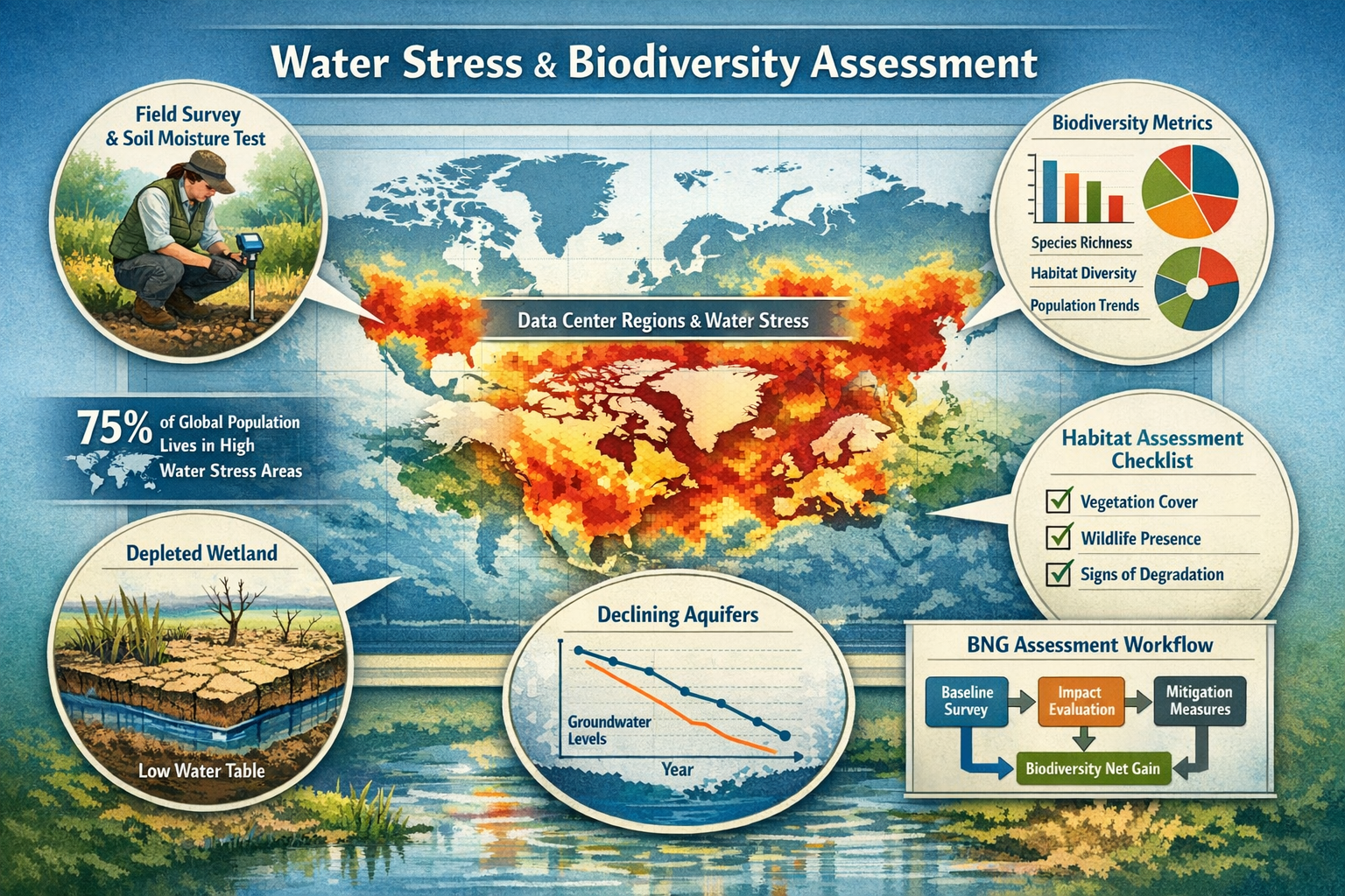
The global landscape of ecological surveying is undergoing a dramatic transformation in 2026. As data centers double their power demand and 43% operate in areas experiencing high water stress, ecology surveyors face unprecedented challenges in conducting accurate biodiversity assessments[1]. The convergence of digital infrastructure expansion and escalating water scarcity is fundamentally altering the habitats surveyors must evaluate, creating urgent demands for new field protocols that can quantify water-ecosystem relationships while maintaining the integrity of Biodiversity Net Gain (BNG) assessments.
This critical intersection represents more than a technical challenge—it's a defining moment for the ecological surveying profession. With 75% of the global population now living in water-insecure or critically water-insecure countries, and 50% of large lakes worldwide having lost significant water volumes since the early 1990s, surveyors must adapt their methodologies to capture the rapid ecological changes occurring in drought-altered landscapes[1]. The stakes are particularly high in regions where data center development intersects with already-stressed water resources, where baseline biodiversity data may no longer reflect current conditions.
Understanding Water Stress Impacts on 2026 Biodiversity Surveys: Field Strategies for Ecology Surveyors in High-Risk Data Center Regions requires a comprehensive approach that integrates hydrological monitoring, adaptive survey techniques, and robust data collection protocols designed specifically for water-limited environments.
Key Takeaways
🔑 Water stress is fundamentally altering baseline biodiversity conditions, with 70% of major aquifers showing long-term decline and 410 million hectares of wetlands lost in five decades, requiring surveyors to adapt assessment methodologies[1]
🔑 Data center expansion in water-stressed regions creates compound ecological pressures, necessitating specialized survey protocols that account for both infrastructure impacts and underlying water scarcity effects on habitat quality
🔑 Temporal survey strategies must be recalibrated to capture drought-driven species shifts, with multiple seasonal assessments essential for accurate biodiversity baseline establishment in high-risk areas
🔑 Integration of hydrological monitoring with traditional biodiversity surveys is now mandatory for reliable BNG calculations, requiring new equipment, training, and interdisciplinary collaboration
🔑 Adaptive field protocols and drought-resistant indicator species identification provide surveyors with practical tools to maintain assessment accuracy despite rapidly changing environmental conditions
Understanding the Global Water Crisis and Its Ecological Implications
The scientific community has formally recognized 2026 as marking humanity's entry into an era of "global water bankruptcy"—a watershed moment where water demand systematically exceeds sustainable supply across vast regions of the planet[1][5]. This isn't merely a resource management challenge; it represents a fundamental restructuring of ecosystems that ecology surveyors must understand and document.
The Scale of Water Depletion
The numbers paint a sobering picture of ecological transformation:
| Water Stress Indicator | Current Status (2026) | Ecological Impact |
|---|---|---|
| Global aquifer decline | 70% showing long-term depletion | Groundwater-dependent ecosystems collapsing |
| Wetland loss | 410 million hectares lost (5 decades) | Critical habitat elimination for specialist species |
| Lake water loss | 50% of large lakes declining | Aquatic biodiversity crashes, riparian habitat degradation |
| Population affected | 3 billion people in declining water storage areas | Increased pressure on remaining water resources[2] |
| Water stress increase | 2.8% rise globally since 2015 (18.6% in 2021) | Accelerating habitat transformation[3] |
These statistics translate directly into field conditions that surveyors encounter daily. Wetlands that appeared on historical maps may now be dry basins. Species composition in riparian zones may have shifted dramatically within just a few years. Traditional survey timing based on historical precipitation patterns may no longer align with actual ecological activity periods.
Water Stress and Biodiversity: The Direct Connections
Water scarcity doesn't simply reduce habitat quantity—it fundamentally alters habitat quality and ecosystem function. Ecology surveyors conducting biodiversity impact assessments must now account for:
Habitat Fragmentation Through Desiccation 💧
As water bodies shrink and wetlands contract, previously continuous habitats become isolated patches. This fragmentation affects species dispersal, genetic diversity, and population viability—all critical factors in biodiversity metric calculations.
Species Composition Shifts
Water-dependent species decline or disappear entirely, while drought-tolerant species may colonize newly arid areas. This creates moving baselines that complicate temporal comparisons essential for impact assessment.
Altered Phenology and Behavior
Breeding seasons, migration patterns, and activity periods shift in response to water availability rather than traditional seasonal cues. Surveyors using standard seasonal timing may miss critical species presence entirely.
Cascading Trophic Effects
Water stress impacts propagate through food webs. Aquatic invertebrate declines affect amphibians, which in turn affect reptiles and birds. Single-taxon surveys may miss these interconnected changes.
"The reality is that 3 billion people and over half of global food production are concentrated in areas where total water storage is already declining or unstable. Ecology surveyors working in these regions aren't documenting stable ecosystems—they're capturing snapshots of systems in rapid transition."[2]
Water Stress Impacts on 2026 Biodiversity Surveys: The Data Center Dimension
Data centers represent one of the fastest-growing infrastructure sectors globally, with power demand projected to double by 2030. However, 43% of existing data centers are located in areas already experiencing high water stress[1]. This geographic concentration creates unique challenges for ecology surveyors conducting pre-development assessments, monitoring studies, and achieving Biodiversity Net Gain in these regions.
Why Data Centers Intensify Water Stress Impacts
Data centers consume enormous quantities of water for cooling systems, with a single large facility using millions of gallons daily. When sited in already water-stressed regions, they create compound ecological pressures:
- Direct water extraction from aquifers or surface water already supporting stressed ecosystems
- Thermal pollution from cooling water discharge affecting aquatic habitats
- Groundwater drawdown expanding the radius of impact beyond the facility footprint
- Competitive water allocation reducing flows to environmental allocations
For ecology surveyors, this means baseline conditions may deteriorate between initial survey and development commencement, invalidating earlier biodiversity assessments. The traditional approach of conducting surveys 12-18 months before development may no longer provide reliable baselines in rapidly changing water-stressed environments.
Regional Hotspots: Where Water Stress and Data Centers Converge
Certain regions face particularly acute challenges where data center expansion intersects with severe water stress:
Western Asia and Northern Africa have experienced a 12% increase in water stress since 2015, reaching critical levels in 2021[3]. Data center development in these regions requires surveyors to work in extreme conditions where:
- Natural water bodies may be ephemeral or entirely seasonal
- Groundwater-dependent vegetation represents the primary biodiversity value
- Species assemblages are already adapted to water scarcity but vulnerable to additional stress
- Traditional UK/European survey methodologies may not translate effectively
Southwestern United States, Mediterranean Europe, and parts of Australia face similar convergence challenges, requiring regionally adapted survey protocols.
Implications for Survey Design and Timing
The Water Stress Impacts on 2026 Biodiversity Surveys: Field Strategies for Ecology Surveyors in High-Risk Data Center Regions demand fundamental reconsideration of survey design:
Extended Temporal Coverage ⏰
Single-season surveys are insufficient. Water availability fluctuations require multi-season assessments spanning at least one full hydrological year, preferably two, to capture:
- Wet season biodiversity when ephemeral habitats are active
- Dry season refugia where species concentrate
- Transition periods when species movement and habitat use patterns shift
- Inter-annual variability in water-dependent species presence
Hydrological Integration
Biodiversity surveys must now incorporate water availability monitoring as a standard component:
- Groundwater level monitoring at multiple points
- Surface water extent mapping using GPS/GIS
- Soil moisture profiling across habitat gradients
- Documentation of water source dependencies for key species
Spatial Expansion
Survey boundaries must extend beyond traditional development footprints to capture:
- Upstream and downstream aquatic connectivity
- Groundwater influence zones based on hydrogeological modeling
- Potential refugia that may gain importance as local conditions deteriorate
- Alternative water sources that species may shift toward
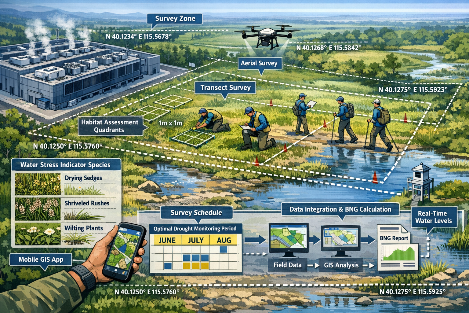
Field Strategies for Ecology Surveyors in High-Risk Data Center Regions
Conducting reliable biodiversity surveys in water-stressed regions near data center developments requires adaptive methodologies that maintain scientific rigor while acknowledging rapidly changing baseline conditions. The following strategies represent current best practices for 2026 field work.
Strategy 1: Implement Water-Informed Survey Protocols
Traditional biodiversity survey protocols were developed for relatively stable environmental conditions. In water-stressed regions, surveyors must adopt water-informed approaches that explicitly integrate hydrological variables:
Baseline Hydrological Assessment
Before conducting biological surveys, establish comprehensive water availability baselines:
- Aquifer characterization: Depth to water table, seasonal fluctuation range, long-term trends
- Surface water mapping: Current extent versus historical maximum (using satellite imagery, historical maps)
- Precipitation analysis: Recent patterns versus 30-year normals, drought severity indices
- Water budget calculation: Inputs (precipitation, runoff) versus outputs (evapotranspiration, extraction)
This hydrological foundation allows surveyors to contextualize biological findings and predict likely trajectories under additional water stress from data center operations.
Habitat Condition Metrics Adjusted for Water Stress
Standard habitat quality assessments may not capture water-stress-specific degradation. Develop modified metrics that include:
| Traditional Metric | Water-Stress Adaptation |
|---|---|
| Vegetation structure diversity | Drought stress indicators (leaf scorch, die-back, species-specific stress symptoms) |
| Ground cover percentage | Soil moisture-dependent cover separately quantified |
| Invasive species presence | Drought-tolerant invasive expansion documented |
| Habitat connectivity | Seasonal connectivity versus permanent connectivity distinguished |
Species-Specific Water Dependency Documentation 🦎
For each recorded species, document water dependency classification:
- Obligate aquatic: Requires permanent water presence
- Facultative aquatic: Uses water when available, can persist in drier conditions
- Riparian dependent: Requires proximity to water but not direct aquatic habitat
- Drought tolerant: Can persist through extended dry periods
- Opportunistic: Colonizes temporarily when water available
This classification enables predictive modeling of community response to additional water stress and informs BNG calculations by identifying species most vulnerable to data center impacts.
Strategy 2: Deploy Specialized Equipment and Technology
Modern survey work in water-stressed environments benefits from technological tools that provide quantitative data on water-ecosystem relationships:
Essential Field Equipment for 2026 🔧
- Soil moisture meters: Portable TDR (Time Domain Reflectometry) or capacitance sensors for rapid soil moisture profiling
- Water quality multi-parameter probes: For documenting baseline conditions in remaining water bodies (temperature, dissolved oxygen, conductivity, pH)
- Groundwater monitoring wells: Temporary or permanent installations for water table tracking
- Trail cameras with environmental sensors: Capture species use of water sources with simultaneous temperature and humidity logging
- Drone-mounted multispectral cameras: Map vegetation stress patterns and water body extent changes
- Portable weather stations: Document microclimate conditions affecting water availability
Digital Data Integration Platforms
Water-stressed environments generate complex, multi-parameter datasets. Effective surveying requires integrated digital platforms that combine:
- Biological observation data (species, abundance, behavior)
- Environmental variables (temperature, humidity, soil moisture)
- Hydrological measurements (water levels, flow rates, water quality)
- Spatial data (GPS coordinates, habitat boundaries, water source locations)
- Temporal metadata (date, time, seasonal context, drought severity index)
Cloud-based platforms enable real-time data validation, pattern detection, and adaptive survey adjustments based on emerging findings.
Strategy 3: Adopt Adaptive Temporal Survey Designs
Fixed survey schedules based on calendar dates fail in water-stressed environments where ecological activity follows water availability rather than seasonal progression. Adaptive temporal designs provide more reliable data:
Trigger-Based Survey Events
Rather than pre-scheduled visits, conduct surveys triggered by hydrological events:
- Post-precipitation surveys: Within 48-72 hours of significant rainfall to document ephemeral species
- Dry season nadir surveys: At peak water stress to identify critical refugia and drought-tolerant species
- Water table threshold surveys: When monitoring wells indicate specific groundwater levels reached
- Seasonal transition surveys: When temperature-moisture combinations indicate likely species activity shifts
Continuous Monitoring Supplements
Supplement periodic surveys with continuous automated monitoring:
- Acoustic recorders for bat and bird activity (solar-powered, months-long deployment)
- Camera traps at water sources (capturing species use patterns 24/7)
- Environmental loggers tracking microclimate (revealing habitat suitability windows)
- Water level loggers providing continuous hydrological context
This combination of triggered surveys and continuous monitoring captures both detailed species data and the environmental context essential for interpreting findings.
Strategy 4: Develop Drought-Resistant Indicator Species Lists
Traditional indicator species may be absent or rare in water-stressed environments. Surveyors need regionally appropriate indicator species that:
- Occur reliably in water-stressed conditions
- Show measurable responses to water availability gradients
- Represent broader community health
- Can be surveyed with standard methods
Building Regional Indicator Lists 📋
Collaborate with regional ecological experts and review recent literature to identify:
- Drought-tolerant amphibians: Species that can persist in temporary water bodies or utilize groundwater seeps
- Arid-adapted reptiles: Lizards and snakes whose presence indicates specific microhabitat conditions
- Water-stress indicator plants: Species whose presence/absence or condition reflects groundwater availability
- Invertebrate assemblages: Aquatic invertebrates adapted to intermittent flows or desiccation-resistant terrestrial species
- Resident bird species: Year-round residents whose breeding success reflects water-dependent food availability
These indicator species provide consistent assessment targets even as overall species composition shifts in response to changing water conditions.
Strategy 5: Integrate Stakeholder Collaboration and Local Knowledge
Data center developments in water-stressed regions involve multiple stakeholders with valuable ecological knowledge:
Hydrologists and Hydrogeologists
Collaboration with water specialists provides:
- Groundwater flow modeling predicting impact zones
- Water budget calculations quantifying available resources
- Aquifer vulnerability assessments
- Cumulative impact predictions considering existing extraction
Local Environmental Managers
Regional conservation staff and land managers offer:
- Historical species presence data
- Observed ecological changes over recent years
- Known refugia and critical habitat areas
- Seasonal patterns and inter-annual variability insights
Indigenous and Traditional Ecological Knowledge
Where appropriate and with proper protocols, traditional knowledge holders can provide:
- Long-term ecological change observations
- Species behavior and habitat use patterns
- Water source locations and reliability
- Cultural significance of specific habitats or species
This collaborative approach enriches survey data and provides context that single-season field work cannot capture.
Quantifying Water-Ecosystem Links for Accurate BNG Assessments
The ultimate goal of biodiversity surveys in development contexts is generating reliable data for Biodiversity Net Gain calculations. Water stress introduces specific challenges to BNG assessment accuracy that require explicit methodological adaptations.
Challenge 1: Baseline Instability
Traditional BNG assumes relatively stable baseline conditions against which development impacts are measured. In water-stressed regions, baselines are moving targets:
- Habitat extent may be shrinking independent of development
- Species composition may be shifting toward drought-tolerant assemblages
- Habitat quality may be declining due to cumulative water stress
Solution: Trajectory-Adjusted Baselines
Rather than single-point baselines, establish trajectory baselines that document:
- Current condition: Standard habitat and species surveys
- Historical condition: Analysis of satellite imagery, historical surveys, local knowledge
- Trend direction: Quantified rate of change over recent years (5-10 year window)
- Projected condition: Modeled future state under current water stress trajectory (without development)
BNG calculations then compare development impacts against the projected baseline rather than current condition, providing more realistic impact quantification.
Challenge 2: Water-Dependent Habitat Distinctiveness
Standard habitat distinctiveness ratings in BNG metrics may not adequately capture the elevated conservation value of water-dependent habitats in water-stressed regions. A small wetland in an arid landscape may support disproportionate biodiversity relative to its size.
Solution: Water-Scarcity Adjusted Distinctiveness Ratings 💎
Apply regional adjustment factors to habitat distinctiveness based on:
- Regional water stress index: Higher adjustments in severely water-stressed regions
- Habitat rarity: Increased distinctiveness for rare water-dependent habitats
- Species dependency: Elevated ratings for habitats supporting water-obligate species
- Refugia function: Additional value for habitats serving as drought refugia
These adjustments ensure BNG calculations appropriately value water-dependent biodiversity in stressed landscapes.
Challenge 3: Uncertainty in Impact Prediction
Predicting how additional water extraction will affect already-stressed ecosystems involves substantial uncertainty. Standard impact assessment may underestimate cumulative effects.
Solution: Precautionary Multipliers and Adaptive Management
Incorporate uncertainty explicitly into BNG calculations:
- Precautionary impact multipliers: Increase predicted impact severity in high-uncertainty situations
- Adaptive management requirements: Mandate post-development monitoring with trigger-based mitigation
- Contingency biodiversity units: Require additional BNG delivery to account for uncertainty
- Phased development approvals: Tie subsequent phases to demonstrated impact accuracy from initial phases
This approach acknowledges uncertainty while maintaining development viability through adaptive, evidence-based progression.
Challenge 4: Temporal Mismatch in Mitigation Delivery
BNG mitigation through habitat creation or enhancement typically requires years to decades to achieve target condition. In rapidly changing water-stressed environments, mitigation timelines may not align with impact timescales.
Solution: Accelerated Mitigation and Alternative Approaches
Prioritize mitigation strategies with faster delivery:
- Habitat restoration over creation: Restoring degraded water-dependent habitats delivers biodiversity value faster than creating new habitats
- Water provision infrastructure: Installing water sources (e.g., wildlife ponds, groundwater-fed wetlands) can rapidly attract species
- Off-site mitigation in stable regions: Consider off-site BNG delivery in less water-stressed areas where mitigation success is more certain
- Financial contributions to regional conservation: Support broader water resource management benefiting ecosystems regionally
These approaches address the temporal mismatch challenge while maintaining BNG integrity.
Advanced Survey Techniques for Water-Limited Environments
Beyond foundational strategies, cutting-edge survey techniques provide enhanced data quality in challenging water-stressed conditions:
Environmental DNA (eDNA) Sampling
eDNA analysis offers particular advantages in water-stressed environments:
Benefits for Water-Stressed Surveys 🧬
- Detects species from minimal water samples: Even small, ephemeral pools yield species presence data
- Captures cryptic and rare species: Species difficult to observe directly leave DNA traces
- Provides temporal integration: DNA persists for days to weeks, integrating species presence over time
- Reduces survey effort: Single water sample can detect multiple taxa simultaneously
Implementation Protocol
- Sample remaining water bodies systematically (multiple samples per water body)
- Include sediment samples from recently dried water bodies (DNA persists in sediment)
- Target multiple taxa (amphibians, fish, invertebrates) with specific primers
- Combine with traditional surveys for validation and abundance estimation
- Archive samples for future analysis as eDNA databases expand
Remote Sensing Integration
Satellite and aerial imagery provide landscape-scale context essential for understanding water-stress impacts:
Key Remote Sensing Applications 🛰️
Vegetation Stress Mapping
- NDVI (Normalized Difference Vegetation Index) time series reveal vegetation health trends
- Thermal imagery identifies water-stressed vegetation before visible symptoms
- Multispectral analysis distinguishes species composition changes
Water Body Extent Tracking
- Historical imagery documents water body shrinkage rates
- Seasonal extent variation quantifies ephemeral versus permanent water
- Predictive modeling forecasts future extent under climate scenarios
Habitat Connectivity Analysis
- Landscape permeability modeling identifies movement corridors
- Fragmentation metrics quantify isolation of habitat patches
- Least-cost path analysis predicts species dispersal routes between water sources
Integration with Field Data
Ground-truth remote sensing products with field observations to develop regionally calibrated models. This enables extrapolation of field survey findings across broader landscapes, improving impact assessment accuracy.
Predictive Species Distribution Modeling
In rapidly changing environments, current species distributions may poorly predict future distributions. Species Distribution Models (SDMs) incorporating water availability variables provide forward-looking insights:
Model Development Process
- Compile species occurrence data: Field surveys plus regional databases
- Assemble environmental predictors: Climate, topography, soil, plus water availability variables (groundwater depth, distance to water, precipitation)
- Develop statistical models: Relate species presence to environmental conditions
- Project under scenarios: Model species distributions under various water stress scenarios
- Identify vulnerable species: Species whose suitable habitat contracts significantly under projected conditions
Application to BNG Assessment
SDMs inform BNG by:
- Identifying species most vulnerable to additional water stress
- Predicting habitat suitability changes from data center water use
- Guiding mitigation placement toward areas with stable future suitability
- Supporting adaptive management by establishing monitoring priorities
Case Study Applications: Practical Implementation Examples
Understanding how these strategies apply in real-world contexts helps surveyors translate theory into practice:
Case Study 1: Data Center Development in Mediterranean Climate Zone
Context: Proposed 50MW data center in southern Spain, region experiencing 15-year drought trend, located near protected wetland complex.
Survey Challenges:
- Wetland extent reduced 40% over past decade
- Traditional survey timing (spring) no longer aligned with amphibian breeding due to earlier, less reliable rainfall
- Protected species (European pond turtle) presence uncertain due to habitat degradation
Applied Strategies:
- Extended temporal coverage: Surveys conducted over 18 months including two wet seasons and intervening dry season
- Hydrological integration: Installed groundwater monitoring wells, documented surface water extent monthly
- eDNA supplementation: Water samples detected turtle DNA in pools where visual surveys found none
- Adaptive timing: Conducted additional surveys following autumn rainfall events that triggered amphibian activity
- Trajectory baseline: Documented 3%/year wetland area decline, projected 10-year baseline for impact comparison
Outcomes:
- BNG assessment identified 25% higher impact than initial estimates due to trajectory baseline approach
- Mitigation design included groundwater supplementation for critical wetland areas
- Monitoring program established with water-level triggers for adaptive management
- Development approved with enhanced water conservation requirements
Case Study 2: Multiple Data Center Expansion in Semi-Arid Region
Context: Cluster of three existing data centers proposing expansions in Arizona, USA, drawing from declining aquifer system.
Survey Challenges:
- Cumulative impacts from existing facilities already affecting riparian habitats
- Baseline data from original developments (10 years prior) no longer valid
- Groundwater-dependent vegetation showing widespread stress symptoms
Applied Strategies:
- Cumulative impact assessment: Surveyed entire aquifer influence zone, not just individual development footprints
- Indicator species focus: Developed regional list of drought-tolerant species as assessment targets
- Remote sensing integration: 20-year NDVI time series documented vegetation stress progression
- Stakeholder collaboration: Partnered with USGS hydrologists for aquifer modeling
- Precautionary multipliers: Applied 1.5x impact multiplier due to cumulative stress uncertainty
Outcomes:
- Regional BNG strategy developed across all three facilities
- Off-site mitigation prioritized in adjacent watershed with more stable water resources
- Shared monitoring program established with data transparency requirements
- Aquifer recharge project funded as partial mitigation
Regulatory Considerations and Compliance
Ecology surveyors must navigate evolving regulatory frameworks that increasingly recognize water-ecosystem linkages:
UK BNG Regulations and Water Stress
While UK BNG regulations don't explicitly address water stress, guidance for developers emphasizes:
- Habitat condition assessment must reflect actual current condition, including water stress impacts
- Mitigation delivery certainty requires realistic assessment of water availability for created/enhanced habitats
- Monitoring and adaptive management should include environmental variables affecting habitat success
Surveyors should document water stress considerations explicitly in assessment reports to support regulatory compliance.
International Standards and Best Practices
For data centers operating internationally, various frameworks apply:
IFC Performance Standards (International Finance Corporation)
- Performance Standard 6 requires biodiversity assessment considering cumulative impacts
- Water resource impacts must be assessed in conjunction with biodiversity impacts
- Mitigation hierarchy applies, with avoidance prioritized in critical habitats
Science-Based Targets for Nature (SBTN)
- Emerging framework requiring companies to assess nature-related dependencies and impacts
- Water stress explicitly included in pressure assessment
- Requires location-specific assessment in high-risk areas
TCFD Nature-Related Disclosures
- Increasing investor pressure for nature-related risk disclosure
- Water stress in operational regions represents material risk
- Biodiversity survey data supports disclosure requirements
Surveyors should familiarize themselves with frameworks relevant to their clients to ensure assessments meet multiple compliance needs.
Training and Professional Development for 2026 Surveyors
The evolving demands of Water Stress Impacts on 2026 Biodiversity Surveys: Field Strategies for Ecology Surveyors in High-Risk Data Center Regions require enhanced professional competencies:
Essential Skill Development Areas
Hydrological Literacy 💧
Surveyors need working knowledge of:
- Groundwater systems and aquifer types
- Surface water hydrology and watershed dynamics
- Water budget concepts and calculations
- Drought indices and water stress metrics
Technology Proficiency
Modern survey work requires competence with:
- GIS and spatial analysis software
- Remote sensing data interpretation
- Environmental sensor deployment and data retrieval
- Statistical modeling software for species distribution models
Interdisciplinary Collaboration
Effective work in complex environments demands:
- Communication skills for working with hydrologists, engineers, regulators
- Project management for coordinating multi-disciplinary teams
- Data integration across different disciplinary frameworks
- Translation of technical findings for non-specialist audiences
Recommended Professional Development Pathways
- Specialized training courses: Hydro-ecology, eDNA methods, remote sensing for ecologists
- Cross-disciplinary workshops: Joint training with hydrologists and water resource managers
- Regional field courses: Hands-on experience in water-stressed environments with local experts
- Professional certifications: Pursue credentials recognizing specialized competencies
- Peer learning networks: Join communities of practice focused on climate-adapted survey methods
Future Outlook: Preparing for Accelerating Change
The water stress challenges facing ecology surveyors in 2026 will likely intensify in coming years. Proactive preparation positions professionals and organizations for continued effectiveness:
Anticipated Trends Through 2030
Expanding Geographic Scope 🌍
Water stress impacts currently concentrated in arid and semi-arid regions will expand into historically water-secure areas as climate patterns shift. Surveyors in temperate regions should begin developing water-stress competencies now.
Regulatory Evolution
Expect increasingly explicit regulatory requirements for:
- Water-ecosystem linkage documentation in biodiversity assessments
- Cumulative impact assessment including water resource pressures
- Climate-adapted mitigation design and monitoring
- Enhanced certainty requirements for mitigation delivery
Technological Advancement
Emerging technologies will enhance survey capabilities:
- AI-powered species identification from camera trap and acoustic data
- Real-time environmental sensor networks providing continuous habitat condition data
- Improved satellite resolution enabling detailed habitat mapping
- Advanced eDNA techniques detecting broader taxonomic ranges
Industry Standardization
Professional bodies will likely develop standardized protocols for water-stressed environment surveys, providing consistency and quality assurance.
Building Organizational Resilience
For ecology surveying firms and environmental consultancies, strategic investments support long-term success:
Equipment and Technology
Invest in specialized equipment for water-stressed environment work, including hydrological monitoring tools and digital data platforms.
Staff Development
Prioritize training in emerging competencies, supporting staff to develop specialized expertise.
Partnership Development
Build relationships with hydrologists, climate scientists, and regional ecological experts to enhance service delivery.
Knowledge Management
Develop internal databases of regional indicator species, water-stress protocols, and lessons learned to accelerate future projects.
Thought Leadership
Contribute to professional discourse through publications, presentations, and participation in standards development.
Conclusion: Navigating the Intersection of Water Stress and Biodiversity Assessment
The convergence of escalating water stress and rapid data center expansion creates unprecedented challenges for ecology surveyors in 2026. With 75% of the global population living in water-insecure countries and 70% of major aquifers in long-term decline, the environmental context for biodiversity assessment has fundamentally shifted[1]. Surveyors can no longer rely on historical baselines, traditional survey timing, or standard protocols developed for stable environments.
However, challenge brings opportunity. Ecology surveyors who develop expertise in Water Stress Impacts on 2026 Biodiversity Surveys: Field Strategies for Ecology Surveyors in High-Risk Data Center Regions position themselves as essential professionals guiding sustainable development in water-limited landscapes. The strategies outlined in this article—water-informed protocols, specialized equipment, adaptive temporal designs, drought-resistant indicators, and stakeholder collaboration—provide practical pathways for maintaining assessment quality while acknowledging environmental dynamism.
Success requires moving beyond traditional ecological survey approaches to embrace interdisciplinary integration, particularly with hydrological sciences. It demands technological adoption, leveraging tools from eDNA to remote sensing that enhance data collection in challenging conditions. Most fundamentally, it requires intellectual flexibility—the willingness to question established methods and adapt to rapidly changing environmental realities.
Actionable Next Steps for Ecology Surveyors
Immediate Actions (Next 30 Days):
- ✅ Assess current project portfolio for water stress risk factors using regional water stress indices
- ✅ Inventory existing equipment and identify gaps in hydrological monitoring capabilities
- ✅ Review recent surveys in water-stressed areas for potential baseline instability issues
- ✅ Initiate conversations with hydrologists or water resource specialists about collaboration opportunities
Short-Term Development (Next 3-6 Months):
- 📚 Complete specialized training in hydro-ecology or water-stressed environment survey methods
- 🔧 Acquire essential equipment including soil moisture meters, water quality probes, and environmental sensors
- 🤝 Establish partnerships with regional water management agencies and hydrological consultancies
- 📊 Develop regional indicator species lists for water-stressed environments in your operating areas
Strategic Positioning (Next 6-12 Months):
- 🎯 Develop specialized service offerings explicitly addressing data center biodiversity assessment in water-stressed regions
- 📖 Create internal protocols documenting water-informed survey approaches for organizational standardization
- 🌐 Build thought leadership through conference presentations, publications, or blog posts on water-stress survey methods
- 🔄 Implement knowledge management systems capturing lessons learned and building institutional expertise
Long-Term Excellence (Next 1-3 Years):
- 🏆 Pursue professional certification or credentials recognizing specialized competencies
- 🔬 Contribute to research advancing understanding of water-ecosystem relationships and survey methodologies
- 📈 Expand service capabilities into predictive modeling, remote sensing integration, and advanced analytical approaches
- 🌍 Develop regional expertise becoming the go-to specialist for specific water-stressed geographic areas
The ecology surveying profession stands at a critical juncture. The skills and approaches that served well in stable environments must evolve to address the dynamic, water-stressed landscapes of 2026 and beyond. Those who embrace this evolution—developing new competencies, adopting innovative technologies, and building interdisciplinary partnerships—will not only survive but thrive, providing essential services that enable sustainable development while protecting the biodiversity upon which all life depends.
The path forward requires commitment, investment, and adaptability. But for professionals dedicated to rigorous ecological science and conservation outcomes, the opportunity to shape biodiversity assessment practices for a water-stressed future represents both a professional challenge and a conservation imperative. By implementing the field strategies outlined here, ecology surveyors can maintain assessment accuracy, support informed decision-making, and ultimately contribute to achieving Biodiversity Net Gain even in the most challenging environmental contexts.
References
[1] World Enters Era Of Global Water Bankruptcy – https://unu.edu/inweh/news/world-enters-era-of-global-water-bankruptcy
[2] 2026 01 World Bankruptcy Scientists – https://phys.org/news/2026-01-world-bankruptcy-scientists.html
[3] Sdg6 Indicator Report 642 Progress Of Water Stress 2024 En – https://www.unwater.org/sites/default/files/2024-12/SDG6_Indicator_Report_642_Progress-of-water-stress_2024_EN.pdf
[4] Wwp2 – https://onlinelibrary.wiley.com/doi/10.1002/wwp2.70062
[5] World Enters Era Global Water Bankruptcy Un Scientists Formally Define Post Crisis Reality – https://www.preventionweb.net/news/world-enters-era-global-water-bankruptcy-un-scientists-formally-define-post-crisis-reality
[6] World Enters New Era Of Water Crisis Un Says – https://healthpolicy-watch.news/world-enters-new-era-of-water-crisis-un-says/
[7] Water Scarcity – https://www.worldwildlife.org/our-work/freshwater/water-scarcity/
