
The biodiversity monitoring landscape is experiencing a revolution. While traditional field surveys remain essential, Private Weather Satellites for Precision Biodiversity Monitoring: Tools for 2026 Ecology Surveyors are transforming how ecologists track species, predict habitat changes, and respond to climate-driven ecosystem shifts. Companies like Tomorrow.io and other private weather data unicorns are exploding onto the scene, offering hyper-local environmental forecasts that enable ecology professionals to predict species movements and refine survey timing amid increasingly extreme weather events. 🌍
This convergence of commercial space technology and ecological science represents more than just a technological upgrade—it's a fundamental shift in how conservation decisions are made. With tiny satellites forming constellations that image the same regions multiple times daily, ecologists now have access to environmental intelligence that was impossible just a few years ago.
Key Takeaways
- Private satellite constellations deliver daily or multiple-daily imaging of ecosystems, enabling detection of rapid biodiversity changes that traditional surveys miss
- Hyper-local weather forecasting from commercial providers helps ecologists optimize survey timing and predict species responses to extreme weather events
- Subscription-based data access eliminates the need for organizations to own satellites, making advanced monitoring tools affordable for ecology teams of all sizes
- AI-assisted analytics transform raw satellite data into actionable biodiversity insights within hours instead of days or weeks
- Integration with Biodiversity Net Gain frameworks allows developers and landowners to demonstrate measurable conservation outcomes using satellite-verified data
The Rise of Commercial Weather Satellites in Ecological Applications
Understanding the Private Satellite Revolution
The commercial space sector has fundamentally changed in recent years. Tiny earth observation satellites are expanding rapidly in 2026, including CubeSats, nanosatellites, and microsatellites deployed in clusters forming constellations that can image the same region daily or multiple times per day[1]. This frequency enables detection of ecosystem changes relevant to biodiversity monitoring that would be invisible to weekly or monthly satellite passes.
Unlike traditional government-operated weather satellites that serve broad national interests, private operators focus on delivering specialized data products tailored to specific customer needs. For ecology surveyors, this means access to:
- High-frequency imaging of critical habitats
- Customized spectral bands optimized for vegetation analysis
- Rapid data processing with cloud-based analytics
- Flexible subscription models that scale with project requirements
The U.S. Space Force recently contracted Muon Space for $44 million to modify commercial weather satellites (Quickbeam sensors with nine spectral channels) for military environmental monitoring, with three satellites planned for on-orbit demonstration under a "data-as-a-service" strategy[4]. This government validation of commercial weather satellite capabilities signals the maturity and reliability of private sector solutions.
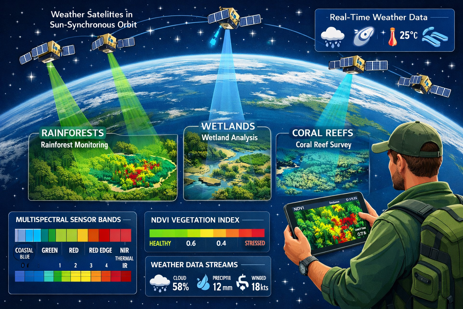
How Sun-Synchronous Orbits Enable Consistent Biodiversity Tracking
Sun-synchronous orbits allow satellites to pass over the same area at roughly the same local time daily, enabling consistent comparison of images over time to detect subtle changes in ecosystems, including habitat expansion or degradation[1]. This consistency is critical for biodiversity monitoring because:
- Lighting conditions remain constant across time-series imagery
- Seasonal comparisons become scientifically valid
- Phenological changes in vegetation can be tracked precisely
- Animal behavior patterns linked to daylight hours can be correlated with habitat conditions
For professionals conducting biodiversity impact assessments, this orbital consistency means baseline surveys can be supplemented with satellite data that provides temporal depth impossible to achieve through field visits alone.
The Data-as-a-Service Model for Ecology Teams
Commercial satellite data is increasingly accessible: Many small-satellite operators now sell access through online platforms and subscription services, allowing individuals and organizations to purchase earth observation data without owning satellites[1]. This democratization of satellite technology means that even small ecology consultancies can leverage space-based monitoring.
The subscription model typically includes:
- Archive access to historical imagery for baseline establishment
- Tasking capabilities to request imaging of specific sites
- Automated alerts when environmental thresholds are exceeded
- API integration with existing biodiversity databases and GIS systems
NOAA and EUMETSAT are expanding commercial weather data acquisition, with microwave sounders moving from pilot phase toward operational procurement, indicating growing reliance on commercial providers for environmental data[3]. This institutional adoption validates the quality and reliability of private satellite services for critical environmental monitoring applications.
Private Weather Satellites for Precision Biodiversity Monitoring: Advanced Sensor Technologies
Multispectral and Hyperspectral Imaging for Habitat Assessment
Optical and multispectral sensors capture data in visible and near-infrared bands used to calculate vegetation indices like NDVI (Normalized Difference Vegetation Index), which indicates vegetation health and can detect early signs of ecosystem stress such as drought or pest infestations[1]. For biodiversity surveyors, these indices provide quantitative measures of habitat quality that complement field observations.
Advanced sensor capabilities include:
| Sensor Type | Spectral Bands | Primary Biodiversity Applications |
|---|---|---|
| Multispectral | 4-12 bands | Vegetation health, land cover classification, water quality |
| Hyperspectral | 100+ bands | Species-level plant identification, soil composition, pollution detection |
| Thermal Infrared | Temperature-sensitive | Animal heat signatures, water stress, urban heat island effects |
| Synthetic Aperture Radar (SAR) | Microwave | All-weather monitoring, forest structure, soil moisture |
The integration of these sensor types enables comprehensive ecosystem characterization that informs biodiversity net gain strategies. For example, combining NDVI trends with thermal data can identify areas where vegetation appears healthy visually but shows water stress indicators—critical intelligence for predicting habitat suitability as climate patterns shift.
Weather Prediction Integration for Survey Optimization
The explosion of private weather data companies like Tomorrow.io represents a game-changer for field ecology. Hyper-local weather forecasting allows surveyors to:
- Schedule field visits during optimal conditions for species detection
- Predict phenological events like flowering, migration, or breeding based on micro-climate forecasts
- Anticipate extreme weather impacts on vulnerable populations or habitats
- Coordinate multi-site surveys across regions with varying weather patterns
This precision timing is particularly valuable for species with narrow detection windows. For instance, amphibian surveys require specific temperature and moisture conditions; satellite-derived weather forecasts can identify the optimal 2-3 day windows months in advance, maximizing survey efficiency.
Space technology plays an increasingly vital role in climate action, with satellites providing essential data for understanding Earth's climate system[6]. This broader climate intelligence helps ecologists contextualize local biodiversity changes within regional and global environmental trends.
AI-Assisted Analytics Transform Raw Data into Ecological Insights
AI-assisted analytics and cloud-based processing are improving data delivery speed, with operators providing ready-to-use images and insights instead of delays of hours or days[1]. Machine learning algorithms trained on ecological datasets can now:
- Automatically classify land cover types with 90%+ accuracy
- Detect changes in habitat extent or quality between image pairs
- Identify individual trees and estimate canopy structure
- Track water body dynamics including seasonal wetland expansion
- Flag anomalies that warrant field investigation
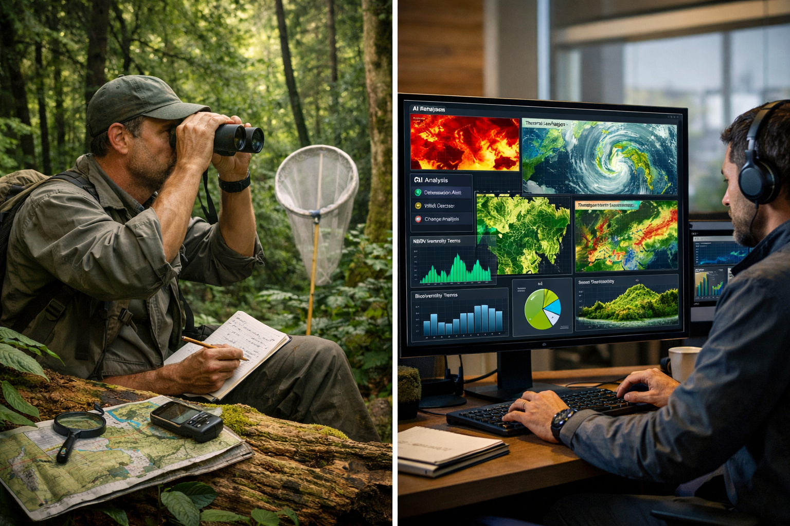
For ecology teams working on achieving biodiversity net gain, these AI tools enable continuous monitoring of conservation interventions. Rather than waiting for annual field surveys to assess whether habitat creation is succeeding, satellite analytics provide monthly or even weekly progress indicators.
The combination of satellite monitoring capabilities[2] with ground-truth field data creates a powerful feedback loop: field observations train AI models to recognize ecological features in satellite imagery, while satellite data guides field teams to areas requiring detailed investigation.
Private Weather Satellites for Precision Biodiversity Monitoring: Practical Applications for 2026 Ecology Surveyors
Baseline Habitat Mapping and Change Detection
One of the most valuable applications of private weather satellites is establishing comprehensive baseline habitat maps across large project areas. Traditional field surveys can thoroughly characterize sample plots, but satellite data extends this characterization across entire landscapes.
The workflow typically involves:
- Historical image analysis to understand habitat trends over 5-10 years
- Current condition mapping using recent high-resolution imagery
- Field validation of satellite-derived habitat classifications
- Ongoing monitoring to detect changes from baseline conditions
This approach is particularly powerful for biodiversity net gain assessments, where demonstrating measurable improvement requires robust baseline documentation and verifiable change detection.
Species Habitat Suitability Modeling
By combining satellite-derived environmental variables with species occurrence data, ecologists can create predictive habitat suitability models that identify:
- Core habitat areas requiring strict protection
- Connectivity corridors linking fragmented populations
- Potential translocation sites for species at risk
- Areas vulnerable to climate-driven habitat loss
Weather satellite data contributes critical variables to these models:
- Temperature regimes including daily minimums, maximums, and variability
- Precipitation patterns and seasonal water availability
- Vegetation productivity as a proxy for food resources
- Microclimate features like frost pockets or heat accumulation zones
For developers planning projects that require biodiversity net gain delivery, these models can identify optimal locations for habitat creation or enhancement that will genuinely benefit target species.
Real-Time Response to Environmental Events
The daily or sub-daily revisit capabilities of modern satellite constellations enable rapid response to environmental disturbances:
- Wildfire impacts on protected habitats
- Flood extent and duration affecting wetland species
- Drought stress triggering early conservation interventions
- Invasive species outbreaks detected through vegetation anomalies
This real-time intelligence transforms ecology from a reactive to a proactive discipline. Rather than discovering ecosystem damage during the next scheduled survey, teams receive alerts within hours of detectable change and can deploy field resources strategically.
Integration with Biodiversity Unit Calculations
For professionals working with biodiversity units and statutory credits, satellite data provides objective evidence of habitat condition changes. The Biodiversity Metric calculations rely heavily on habitat distinctiveness and condition assessments—both of which can be partially informed by satellite-derived indicators.
Satellite-supported metric inputs include:
- Vegetation structure complexity (from LiDAR-equipped satellites)
- Habitat extent and connectivity
- Temporal stability of habitat features
- Evidence of management interventions (mowing, grazing, planting)
While satellite data cannot replace expert field assessment for detailed condition scoring, it provides temporal continuity between field visits and can flag areas where conditions may have changed significantly, warranting reassessment.
Monitoring Off-Site Biodiversity Gain Delivery
For landowners selling biodiversity units or developers purchasing units, satellite monitoring offers independent verification that habitat creation or enhancement is proceeding as planned. This is particularly valuable for:
- Long-term habitat banking arrangements spanning decades
- Off-site compensation where developers have limited direct oversight
- Adaptive management adjustments based on measurable outcomes
- Regulatory compliance demonstration with objective evidence
The combination of satellite monitoring and periodic field validation creates a cost-effective verification framework that builds confidence in biodiversity markets while reducing the burden of continuous on-site inspection.
Selecting the Right Satellite Data Services for Biodiversity Projects
Evaluating Commercial Satellite Data Providers
The proliferation of private satellite operators means ecology teams face genuine choices when selecting data services. Key evaluation criteria include:
Spatial Resolution:
- High resolution (0.5-3m): Individual tree identification, detailed habitat mapping
- Medium resolution (3-10m): Habitat patch delineation, land cover classification
- Coarse resolution (10-30m): Landscape-scale trends, regional assessments
Temporal Resolution:
- Daily imaging: Rapid change detection, event response
- Weekly imaging: Phenological tracking, seasonal monitoring
- Monthly imaging: Trend analysis, annual reporting
Spectral Capabilities:
- Standard RGB: Basic visualization, public engagement
- Multispectral (4-12 bands): Vegetation indices, water quality
- Hyperspectral (100+ bands): Species discrimination, detailed composition
Data Processing Level:
- Raw imagery: Maximum flexibility, requires expertise
- Orthorectified products: Geometrically corrected, GIS-ready
- Analysis-ready data: Atmospherically corrected, pre-processed
- Insight products: AI-analyzed, decision-ready information
Cost-Benefit Analysis for Ecology Consultancies
Implementing satellite monitoring involves both direct costs (data subscriptions, software licenses) and indirect costs (staff training, workflow integration). However, the benefits often substantially outweigh these investments:
Quantifiable Benefits:
- Reduced field visit frequency (20-40% cost savings)
- Expanded monitoring coverage (5-10x more area per project)
- Earlier problem detection (preventing costly remediation)
- Enhanced client reporting (demonstrating ongoing stewardship)
Strategic Benefits:
- Competitive differentiation in biodiversity surveying markets
- Improved accuracy of biodiversity predictions
- Stronger regulatory compliance documentation
- Enhanced ability to serve multiple simultaneous projects
For small to medium consultancies, subscription models starting at several hundred pounds monthly provide access to satellite capabilities that would have required millions in capital investment just a decade ago.
Building Internal Capacity for Satellite Data Interpretation
Successfully integrating satellite monitoring requires developing organizational capabilities beyond simply purchasing data access:
- Staff training in remote sensing fundamentals and ecology-specific applications
- GIS infrastructure capable of handling large raster datasets
- Quality control protocols for validating satellite-derived insights with field data
- Client communication strategies for explaining satellite-based evidence
Many satellite data providers now offer turnkey solutions that include training, technical support, and customized analytics, reducing the barrier to entry for ecology teams without remote sensing expertise.
Regulatory and Ethical Considerations
Data Quality Standards for Regulatory Submissions
As satellite-derived evidence becomes more common in biodiversity net gain reports and planning applications, regulators are developing standards for acceptable data quality and interpretation. Key considerations include:
- Validation requirements: What level of field verification is needed?
- Temporal appropriateness: How recent must satellite data be?
- Uncertainty quantification: How should confidence levels be reported?
- Chain of custody: Documentation of data sources and processing steps
Ecology surveyors should work closely with local planning authorities to understand their specific requirements and expectations for satellite-supported submissions.
Privacy and Landowner Consent
High-resolution satellite imagery can reveal detailed information about private land management practices. While satellite data of the UK is generally not restricted, ethical practice suggests:
- Informing landowners when their properties will be monitored
- Securing appropriate permissions for detailed analysis
- Protecting commercially sensitive information about land management
- Using aggregated data for public reporting when possible
These considerations are particularly important when working with landowners on biodiversity unit creation, where trust and transparency are essential to long-term partnerships.
Limitations and the Continued Importance of Field Surveys
Despite their power, satellites cannot replace boots-on-the-ground ecology. Critical limitations include:
- Species-level identification remains challenging for most fauna and many flora
- Understory conditions in forests are invisible from orbit
- Behavioral observations require direct observation
- Soil characteristics need physical sampling
- Rare species detection often requires targeted field methods
The optimal approach combines satellite monitoring for broad-scale, continuous tracking with strategic field surveys for detailed, species-specific assessment. This hybrid methodology maximizes cost-effectiveness while maintaining scientific rigor.
Future Trends in Satellite-Enabled Biodiversity Monitoring
Emerging Sensor Technologies
The next generation of private weather and earth observation satellites will include:
- Thermal imaging at higher resolution for individual animal detection
- LiDAR from small satellites for detailed 3D forest structure
- Acoustic sensors for bioacoustic monitoring from low orbit
- Environmental DNA (eDNA) correlation with satellite-detected habitat features
These advances will further blur the line between remote and in-situ monitoring, enabling increasingly sophisticated biodiversity assessments from space.
Integration with IoT and Ground Sensor Networks
The future of biodiversity monitoring lies in integrated sensor networks that combine:
- Satellite observations (broad coverage, moderate detail)
- Aerial drones (targeted high-resolution imaging)
- Ground-based sensors (continuous point measurements)
- Camera traps and acoustic recorders (species-specific data)
This multi-scale monitoring provides comprehensive ecosystem intelligence that no single technology can achieve alone. Private weather satellites serve as the backbone of these systems, providing the environmental context within which ground sensors operate.
Artificial Intelligence and Predictive Ecology
Machine learning models trained on decades of satellite data are beginning to predict future biodiversity changes based on environmental trajectories. These predictive capabilities enable:
- Proactive conservation planning before species decline
- Climate adaptation strategies informed by projected habitat shifts
- Early warning systems for ecosystem tipping points
- Scenario modeling for development planning and mitigation design
For professionals working on creating biodiversity plans for development projects, these predictive tools will become essential for designing conservation interventions that remain effective under future climate scenarios.
The Role of Satellite Data in Global Biodiversity Frameworks
International initiatives like the post-2020 Global Biodiversity Framework increasingly rely on satellite-verified metrics for tracking progress toward conservation targets. This creates opportunities for:
- Standardized biodiversity monitoring protocols across nations
- Carbon and biodiversity co-benefit verification
- Transparent reporting of conservation finance outcomes
- Integration with climate action frameworks
Recent insights in climate science emphasize the interconnections between biodiversity loss and climate change[5], highlighting the need for monitoring systems that track both simultaneously—a natural strength of integrated satellite platforms.
Conclusion: Embracing the Satellite Revolution in Ecology

Private Weather Satellites for Precision Biodiversity Monitoring: Tools for 2026 Ecology Surveyors represent far more than a technological novelty—they are becoming essential infrastructure for effective conservation in an era of rapid environmental change. The convergence of affordable commercial satellite access, hyper-local weather forecasting, and AI-assisted analytics has created unprecedented opportunities for ecology professionals to monitor ecosystems with precision and frequency previously unimaginable.
For surveyors working within frameworks like Biodiversity Net Gain, satellite monitoring offers objective, continuous verification of conservation outcomes that strengthens both regulatory compliance and ecological effectiveness. The ability to detect subtle habitat changes within weeks rather than years enables adaptive management that responds to ecosystem dynamics in near-real-time.
Actionable Next Steps for Ecology Teams
1. Assess Your Current Monitoring Needs:
- Identify projects that would benefit from more frequent monitoring
- Calculate the cost of current field survey approaches
- Determine what environmental variables are most critical to your work
2. Explore Commercial Satellite Options:
- Request demonstrations from 2-3 satellite data providers
- Start with a pilot project on a single site
- Evaluate data quality against your field observations
3. Build Internal Capacity:
- Invest in GIS training for key staff members
- Develop protocols for integrating satellite and field data
- Create client-facing materials explaining satellite-based evidence
4. Engage with Regulators:
- Discuss satellite data acceptance with local planning authorities
- Contribute to development of standards and best practices
- Share case studies demonstrating successful integration
5. Stay Informed:
- Monitor emerging satellite technologies and service offerings
- Participate in professional development on remote sensing applications
- Connect with peers experimenting with satellite-enabled monitoring
The ecology surveyors who embrace these tools now will be best positioned to deliver the rigorous, cost-effective biodiversity monitoring that conservation and development projects increasingly demand. As extreme weather events become more frequent and ecosystems face accelerating pressures, the combination of satellite intelligence and field expertise will be essential for protecting and enhancing biodiversity in the built and natural environment.
The future of biodiversity monitoring is already here—it's orbiting overhead, ready to transform how we understand and protect the living world. 🛰️🌿
References
[1] Tiny Earth Observation Satellites 2026 How They Track Weather Crops Shipping – https://www.techtimes.com/articles/314591/20260212/tiny-earth-observation-satellites-2026-how-they-track-weather-crops-shipping.htm
[2] Satellite Monitoring – https://www.planet.com/products/satellite-monitoring/
[3] Earth Observation Outlook Predictions For 2026 – https://newsletter.terrawatchspace.com/earth-observation-outlook-predictions-for-2026/
[4] Space Force Contract Inform Commercial Weather Strategy – https://www.airandspaceforces.com/space-force-contract-inform-commercial-weather-strategy/
[5] Ten New Insights Climate Science – https://www.preventionweb.net/news/ten-new-insights-climate-science
[6] Space Technology – https://www.unoosa.org/oosa/en/ourwork/topics/space4climateaction/space-technology.html
