
The ground beneath our feet is changing in ways that demand immediate attention from ecological surveyors, land managers, and conservation professionals. As we advance through 2026, soil moisture decline has emerged as one of the most pressing environmental challenges affecting terrestrial ecosystems worldwide. This phenomenon isn't a temporary drought cycle—research indicates we may be witnessing a permanent shift in Earth's water dynamics that fundamentally alters how we conduct ecological assessments and manage biodiversity.
For professionals conducting terrestrial ecology surveys in 2026, understanding and accurately documenting soil moisture conditions has become essential to delivering meaningful biodiversity impact assessments. The implications extend far beyond immediate survey findings, affecting long-term habitat viability, species distribution patterns, and the success of conservation interventions.
This comprehensive guide explores Navigating Soil Moisture Decline in Terrestrial Ecology Surveys: 2026 Field Protocols and Impacts, providing field ecologists, environmental consultants, and land managers with the knowledge and protocols needed to adapt survey methodologies to this changing reality.
Key Takeaways
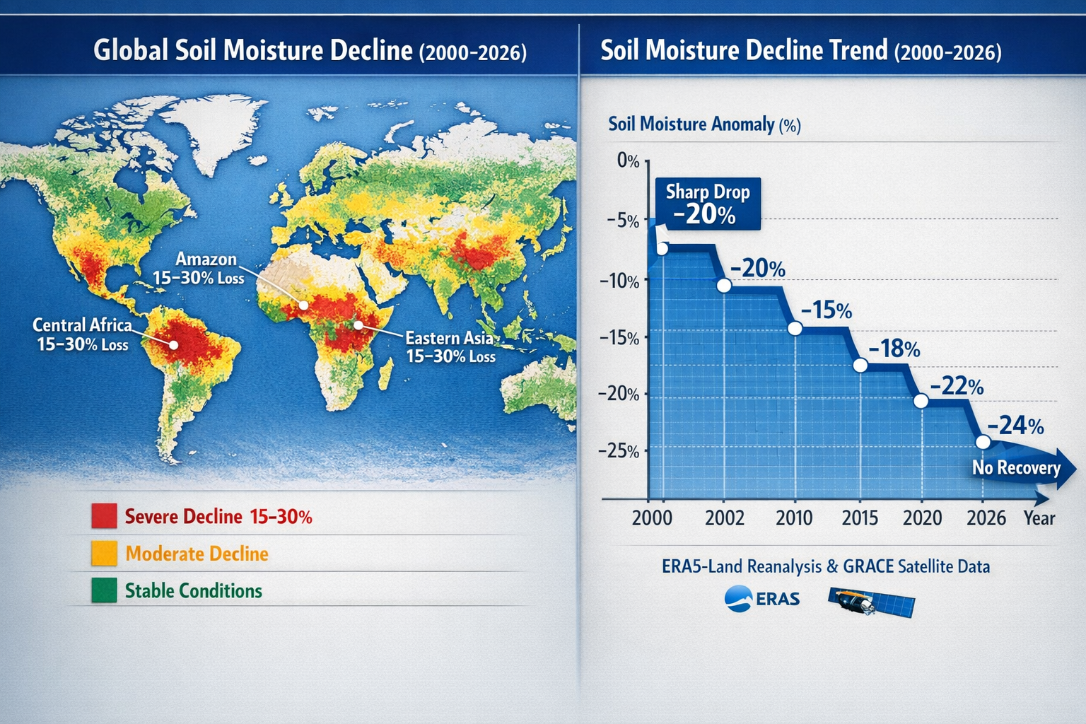
🌍 Global soil moisture has been in continuous decline since 2000, with research confirming this represents a potential permanent shift in the world's water cycle rather than a temporary fluctuation[2]
📊 Two distinct periods of stepwise decline occurred in the past two decades, with a sharp depletion during 2000-2002 followed by gradual decline through 2021 with no recovery observed[2]
🔬 Updated 2026 field protocols must incorporate multi-depth moisture monitoring, seasonal baseline adjustments, and integration with evapotranspiration data to accurately assess ecosystem health
🌱 Biodiversity impacts are cascading, affecting vegetation composition, species distributions, food security, and carbon storage capacity across terrestrial ecosystems
⚡ Survey methodologies require adaptation to account for moisture-stressed baseline conditions when evaluating habitat quality and biodiversity net gain potential
Understanding the Science Behind Soil Moisture Decline
The Global Pattern of Moisture Loss
The evidence for widespread soil moisture decline has become increasingly compelling as we move through 2026. Research published in Science in March 2025 documented that global soil moisture has been in continuous decline since approximately 2000, representing what scientists warn could be a permanent transformation of Earth's water cycle if current warming trends persist[2].
This isn't a uniform or gradual process. The decline has followed a distinctive stepwise pattern characterized by two major phases:
- Sharp initial depletion (2000-2002): A rapid decrease in soil moisture levels across multiple continents
- Gradual sustained decline (2003-2021): Continuing moisture loss with no observed recovery periods
What makes this pattern particularly concerning for terrestrial ecology surveys is that these stepwise declines represent a phenomenon not observed in earlier decades[2]. This suggests we've crossed into new hydrological territory that requires fundamentally different assessment approaches.
Regional Variations and Hotspots
Soil moisture depletion has been mapped across extensive regions including:
- Eastern and central Asia: Significant moisture deficits affecting grassland and forest ecosystems
- Central Africa: Declining moisture in critical biodiversity zones
- North and South America: Widespread impacts including the Amazon rainforest, which experienced steady deforestation during 2010-2020 with an estimated 36,000 km² in deforestation areas correlating to strong vegetation water content decreases[1]
Conversely, only relatively small portions of South America, India, Australia, and North America showed soil moisture increases during the 2008-2012 period[2]. These limited replenishment zones cannot offset the broader global trend.
Primary Drivers of Moisture Decline
Understanding the mechanisms behind soil moisture loss is essential for interpreting survey data in 2026. The primary factors include:
Climate and Precipitation Changes: Precipitation deficits combined with stable or increasing evapotranspiration rates—driven by global warming and shifting rainfall patterns—serve as the primary drivers of moisture decline[3].
Increasing Evaporative Demand: Rising global temperatures create greater "evaporative demand" from the atmosphere, pulling more moisture from soils even when precipitation remains relatively constant[2].
Ocean Temperature Linkages: Increasing ocean temperatures correlate strongly with terrestrial water storage losses, suggesting interconnected climate system feedbacks[3].
Agricultural Intensification: Regions experiencing increasing agricultural irrigation, such as northeast China and the western United States, paradoxically show further soil moisture diminishment in surrounding semi-arid areas[3].
Vegetation Greening Paradox: Global "greening" trends in semi-arid regions—where vegetation cover has increased—may actually contribute to soil moisture decline through increased water consumption by plants[2][3].
Navigating Soil Moisture Decline in Terrestrial Ecology Surveys: Updated 2026 Field Protocols
Essential Equipment and Measurement Standards
Conducting accurate terrestrial ecology surveys in moisture-stressed environments requires updated equipment specifications and measurement protocols for 2026:
Multi-Depth Soil Moisture Probes: Standard practice now requires measurements at minimum three depths:
- Surface layer (0-10 cm): Immediate moisture availability for herbaceous vegetation
- Root zone (10-30 cm): Critical for most grassland and shrub species
- Deep soil (30-60 cm): Essential for tree species and drought resilience assessment
Calibrated Measurement Devices: Time Domain Reflectometry (TDR) or Frequency Domain Reflectometry (FDR) sensors calibrated for local soil types provide the most reliable field measurements.
Portable Weather Stations: Integration of on-site evapotranspiration measurements helps contextualize soil moisture readings within current atmospheric demand conditions.
GPS and Spatial Mapping Tools: Georeferencing all moisture measurement points enables temporal comparison and spatial pattern analysis across survey sites.
Sampling Protocols for Moisture-Stressed Environments
The 2026 field protocols for Navigating Soil Moisture Decline in Terrestrial Ecology Surveys emphasize systematic approaches that account for increased spatial variability:
Site Selection and Grid Design
Stratified random sampling remains the gold standard, but grid density should increase in heterogeneous landscapes where moisture availability varies significantly across short distances. Recommended minimum sampling densities:
| Habitat Type | Minimum Points per Hectare | Measurement Frequency |
|---|---|---|
| Grassland | 4-6 points | Monthly during growing season |
| Woodland | 6-8 points | Bi-monthly |
| Wetland margins | 8-12 points | Weekly during critical periods |
| Agricultural boundaries | 5-7 points | Monthly |
Temporal Considerations
Seasonal baseline adjustments are critical in 2026. Historical moisture baselines from pre-2000 data no longer reflect current conditions. Surveyors should:
- Establish contemporary baseline references using 2020-2026 data where available
- Conduct measurements during standardized phenological stages rather than fixed calendar dates
- Document antecedent precipitation for the 7, 14, and 30 days prior to survey
- Record soil temperature alongside moisture readings to account for seasonal variation
Quality Control Measures
Calibration verification should occur at the start of each field day:
- Test probes against known moisture standards
- Cross-check readings between multiple devices
- Document any equipment drift or malfunction
- Maintain detailed equipment logs with serial numbers and calibration dates
Data Integration and Interpretation
Raw soil moisture measurements gain meaning only when integrated with complementary ecological data. The 2026 protocols emphasize multi-parameter assessment:
Vegetation Condition Indices: Correlate moisture readings with:
- Normalized Difference Vegetation Index (NDVI) from satellite imagery
- Ground-truthed vegetation health scores
- Species composition shifts toward drought-tolerant taxa
- Evidence of moisture stress (leaf wilting, premature senescence, reduced growth)
Hydrological Context: Link soil measurements to:
- Local water table depth and fluctuation patterns
- Surface water availability in adjacent features
- Catchment-scale precipitation trends
- Irrigation or water management influences
Biodiversity Indicators: Assess how moisture conditions affect:
- Species richness and diversity metrics
- Presence/absence of moisture-dependent species
- Reproductive success indicators (flowering, seed set, recruitment)
- Invertebrate community composition
This integrated approach ensures that biodiversity impact assessments accurately reflect the cascading effects of moisture decline on ecosystem function.
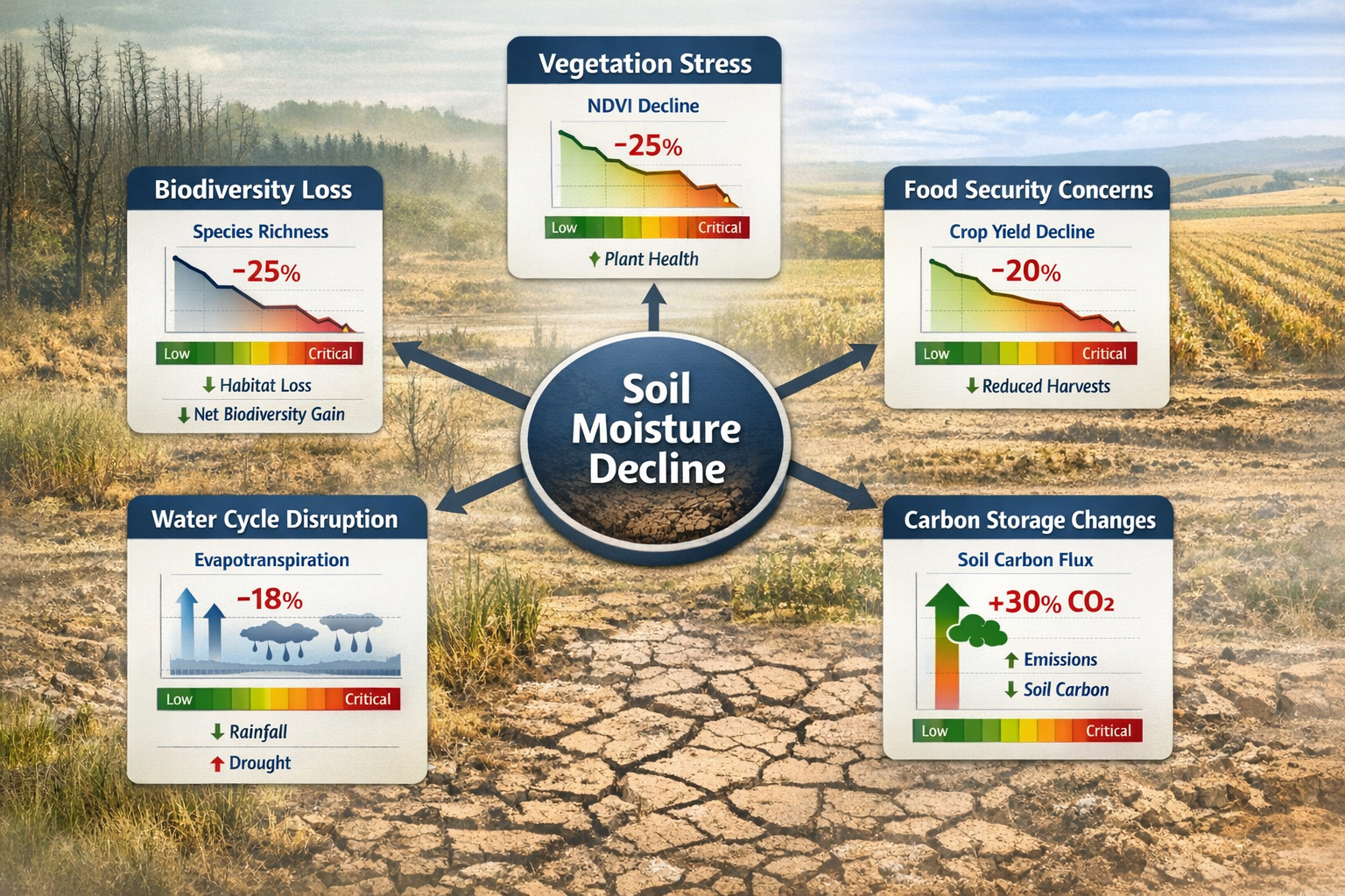
Ecological Impacts of Soil Moisture Decline on Survey Outcomes
Vegetation Community Shifts
Soil moisture decline fundamentally alters plant community composition, creating challenges for baseline vegetation surveys and habitat classification. Key impacts observed in 2026 include:
Species Turnover: Moisture-dependent species decline while drought-tolerant species increase in abundance. This shift can occur rapidly—within 3-5 years in grassland systems—making historical vegetation data increasingly unreliable for comparison.
Structural Changes: Reduced moisture availability leads to:
- Decreased canopy cover in woodland habitats
- Lower vegetation height and biomass in grasslands
- Increased bare ground exposure
- Altered flowering phenology and shortened growing seasons
Functional Group Dynamics: Shifts from mesophytic to xerophytic plant functional groups change ecosystem services, including:
- Reduced carbon sequestration capacity
- Altered nutrient cycling rates
- Modified microclimate conditions
- Changed habitat structure for fauna
These vegetation changes directly impact biodiversity net gain calculations, as habitat distinctiveness and condition scores may decline even without direct human disturbance.
Faunal Response Patterns
Animal communities respond to soil moisture decline both directly and indirectly through vegetation changes:
Invertebrate Communities: Soil moisture critically affects:
- Earthworm abundance and activity (key soil engineers)
- Ground-dwelling beetle diversity
- Pollinator availability (through flowering plant impacts)
- Decomposer community function
Amphibian and Reptile Populations: Moisture-dependent species face particular challenges:
- Reduced breeding habitat availability
- Increased desiccation risk during vulnerable life stages
- Altered thermal regulation opportunities
- Compressed activity windows
Bird and Mammal Distributions: Indirect effects cascade through:
- Reduced prey availability (invertebrate declines)
- Altered vegetation structure affecting nesting and shelter
- Water source availability and distribution
- Food plant phenology mismatches
Habitat Condition Assessment Challenges
Traditional habitat condition assessment frameworks require recalibration for moisture-stressed environments. When conducting surveys in 2026, consider:
Adjusted Condition Criteria: Historical "good condition" benchmarks may no longer be achievable under current moisture regimes. Assessment frameworks should:
- Reference contemporary analogues rather than historical baselines
- Account for climate-driven stress as distinct from management-related degradation
- Recognize transitional states where habitats shift toward new stable configurations
Temporal Variability: Moisture decline increases year-to-year variability in habitat metrics, requiring:
- Multi-year survey programs for accurate trend detection
- Probabilistic rather than deterministic condition classifications
- Explicit uncertainty quantification in assessment reports
Spatial Heterogeneity: Moisture availability creates fine-scale habitat mosaics, necessitating:
- Higher resolution mapping than traditional broad habitat classifications
- Recognition of moisture refugia as critical biodiversity hotspots
- Corridor and connectivity assessments focused on moisture gradients
Implications for Biodiversity Net Gain and Development Projects
Assessing Baseline Conditions in Moisture-Stressed Landscapes
For developers and consultants working on projects requiring biodiversity net gain compliance, soil moisture decline introduces significant complications to baseline assessment:
Declining Baseline Trajectories: Sites surveyed in 2026 may show lower biodiversity value than the same sites assessed in 2020, purely due to moisture stress rather than land use change. This creates challenges for:
- Determining appropriate baseline reference dates
- Accounting for climate-driven losses versus development impacts
- Setting realistic enhancement targets
Condition Score Adjustments: Standard habitat condition assessment criteria may need modification to avoid penalizing sites for climate-driven changes beyond landowner control. Consider:
- Separating climate stress indicators from management quality indicators
- Adjusting scoring thresholds based on regional moisture trends
- Documenting moisture context in condition justifications
Temporal Baseline Selection: The choice of baseline survey timing becomes critical:
- Spring surveys may capture residual winter moisture
- Late summer surveys reveal maximum stress conditions
- Multi-season surveys provide more robust characterization
Enhancement and Creation Strategies
Navigating Soil Moisture Decline in Terrestrial Ecology Surveys: 2026 Field Protocols and Impacts extends to designing effective habitat creation and enhancement schemes:
Moisture-Resilient Habitat Types: Prioritize creation of habitats with inherent drought tolerance:
- Calcareous grasslands on free-draining soils
- Scrub mosaics with deep-rooted species
- Woodland with drought-tolerant native species mixes
- Habitat features that capture and retain moisture (swales, ponds)
Irrigation and Water Management: While generally discouraged in natural habitat creation, targeted moisture management may be necessary for:
- Establishment phase of new plantings (first 2-3 years)
- Critical moisture refugia for priority species
- Wetland habitat maintenance in declining water table areas
Adaptive Management Provisions: Biodiversity management plans should include:
- Moisture monitoring requirements and response triggers
- Contingency actions if moisture stress exceeds thresholds
- Species substitution protocols for failed plantings
- Flexible success criteria that account for climate variability
Off-Site Compensation Considerations
When on-site biodiversity net gain proves challenging due to moisture constraints, off-site biodiversity units become increasingly important:
Site Selection Criteria: Prioritize off-site locations with:
- More favorable moisture regimes (higher rainfall zones, proximity to water sources)
- Soil types with better water retention capacity
- Topographic positions that accumulate moisture
- Lower evapotranspiration demand (cooler microclimates, north-facing slopes)
Spatial Risk Distribution: Diversifying off-site compensation across multiple locations and moisture gradients reduces climate risk to overall net gain delivery.
Long-Term Viability Assessment: Enhanced due diligence on moisture trends at proposed off-site locations ensures 30-year habitat viability, including:
- Historical moisture trend analysis (2000-2026)
- Climate projection downscaling for specific sites
- Hydrogeological assessment of water table sustainability
Regional Considerations and Case Studies
Amazon Basin: Deforestation and Moisture Feedback
The Amazon rainforest provides a stark example of moisture decline impacts on terrestrial ecology. During 2010-2020, steady deforestation resulted in an estimated 36,000 km² of forest loss, correlating with strong vegetation water content decreases[1].
Survey Implications: Ecologists working in tropical regions must account for:
- Deforestation feedback loops where forest loss reduces regional precipitation
- Edge effects extending hundreds of meters into remaining forest fragments
- Altered microclimates in fragmented landscapes affecting species distributions
- Rapid compositional shifts toward drought-tolerant species assemblages
Semi-Arid Agricultural Landscapes
In regions like northeast China and the western United States, agricultural intensification paradoxically worsens moisture stress in surrounding natural habitats[3]:
Survey Challenges:
- Distinguishing irrigation-induced moisture gradients from natural patterns
- Assessing habitat quality in agricultural buffer zones
- Accounting for competing water demands between agriculture and natural systems
- Evaluating biodiversity value in moisture-stressed field margins
Protocol Adaptations:
- Expanded sampling grids to capture irrigation influence zones
- Coordination with agricultural water use data
- Seasonal timing to avoid irrigation-influenced periods
- Focus on drought-resistant habitat types for enhancement
Wetland and Riparian Systems
Wetland margins and riparian corridors face particular vulnerability to soil moisture decline, requiring specialized survey approaches:
Hydrological Monitoring: Standard vegetation surveys must integrate:
- Water table depth measurements
- Surface water extent mapping across seasons
- Hydroperiod characterization (duration and frequency of inundation)
- Connectivity to groundwater sources
Transitional Zone Assessment: The boundary between wetland and upland habitats shifts with moisture availability, necessitating:
- Multi-year boundary mapping to detect trends
- Recognition of ephemeral wetland features
- Assessment of moisture-dependent species at range limits
Integration with Broader Environmental Assessment Frameworks
Climate Adaptation Planning
Navigating Soil Moisture Decline in Terrestrial Ecology Surveys: 2026 Field Protocols and Impacts aligns with broader climate adaptation strategies:
Nature-Based Solutions: Soil moisture data informs design of:
- Natural flood management features that also enhance moisture retention
- Green infrastructure that reduces urban heat island effects and evapotranspiration
- Habitat corridors along moisture gradients facilitating species range shifts
Ecosystem-Based Adaptation: Survey data supports:
- Identification of climate refugia for protection prioritization
- Assessment of ecosystem adaptive capacity
- Targeting of restoration efforts to maximize climate resilience
Sustainable Land Management
Soil moisture monitoring bridges ecological survey work with agricultural and forestry management:
Sustainable Farming Incentive (SFI) Alignment: Ecological surveys can support sustainable farming initiatives by:
- Documenting baseline soil health indicators
- Monitoring effectiveness of soil moisture conservation practices
- Assessing biodiversity co-benefits of improved water management
Integrated Land Use Planning: Moisture data enables:
- Zoning decisions based on water resource sustainability
- Allocation of land uses to areas with appropriate moisture regimes
- Strategic placement of development to avoid moisture-stressed conservation priority areas
Carbon and Water Cycle Linkages
Soil moisture decline affects both biodiversity and carbon sequestration, creating synergies for:
Carbon Storage Assessment: Moisture-stressed soils show altered carbon dynamics through:
- Reduced plant biomass accumulation
- Changed decomposition rates
- Modified soil organic matter formation
- Altered methane and nitrous oxide fluxes in wetlands
Integrated Monitoring: Combined moisture-carbon-biodiversity monitoring provides comprehensive ecosystem health assessment supporting multiple policy objectives.
Technology and Innovation in Moisture Monitoring
Remote Sensing Applications
Advances in satellite remote sensing provide powerful tools for navigating soil moisture decline at landscape scales:
Satellite Platforms: Multiple data sources now available for 2026 surveys:
- ERA5-Land reanalysis: Global soil moisture estimates at 9km resolution
- SMAP (Soil Moisture Active Passive): NASA mission providing soil moisture data
- Sentinel satellites: High-resolution vegetation indices correlating with moisture stress
Integration with Field Data: Ground-truthing satellite observations with field measurements enables:
- Spatial extrapolation of point measurements across survey areas
- Historical trend analysis using archived satellite data
- Real-time monitoring of moisture conditions between field visits
Sensor Networks and IoT
Permanent or semi-permanent sensor installations provide continuous moisture monitoring:
Advantages:
- High temporal resolution capturing rapid moisture fluctuations
- Reduced field visit requirements
- Early warning of drought stress events
- Long-term datasets for trend analysis
Deployment Considerations:
- Initial installation costs versus long-term data value
- Maintenance and calibration requirements
- Data management and quality control protocols
- Integration with existing monitoring programs
Predictive Modeling
Machine learning and process-based models increasingly support survey planning and interpretation:
Moisture Prediction Models: Forecasting soil moisture conditions enables:
- Optimal timing of field surveys
- Scenario planning for habitat management
- Risk assessment for biodiversity net gain delivery
Species Distribution Models: Integrating moisture variables improves:
- Habitat suitability mapping
- Prediction of climate-driven range shifts
- Targeting of survey effort for rare species
Training and Capacity Building for 2026 Survey Teams
Essential Skills and Knowledge
Survey teams working in moisture-stressed environments require expanded competencies:
Technical Skills:
- ✅ Proper use and calibration of soil moisture measurement equipment
- ✅ Interpretation of moisture data in ecological context
- ✅ Integration of remote sensing products with field observations
- ✅ Statistical analysis of spatially and temporally variable moisture data
Ecological Understanding:
- ✅ Recognition of moisture stress symptoms in vegetation
- ✅ Knowledge of drought tolerance traits across plant and animal taxa
- ✅ Understanding of soil-water-plant-atmosphere continuum
- ✅ Awareness of climate-driven ecosystem transitions
Regulatory Knowledge:
- ✅ Current biodiversity net gain requirements and guidance
- ✅ Habitat condition assessment frameworks and adaptations
- ✅ Climate change considerations in environmental impact assessment
- ✅ Emerging policy on climate adaptation and nature-based solutions
Professional Development Resources
Staying current with evolving protocols requires ongoing learning:
Industry Guidance: Organizations like CIEEM (Chartered Institute of Ecology and Environmental Management) provide updated technical guidance on climate-adapted survey methods.
Scientific Literature: Regular review of journals publishing soil moisture and terrestrial ecology research ensures awareness of emerging findings.
Peer Networks: Participation in professional communities facilitates knowledge exchange on field challenges and solutions.
Specialized Training: Workshops and courses on soil science, hydrology, and climate change ecology complement traditional ecological survey training.
Quality Assurance and Reporting Standards
Documentation Requirements
Comprehensive documentation ensures survey findings can be interpreted correctly and compared over time:
Minimum Reporting Elements for moisture-inclusive terrestrial ecology surveys:
- Equipment specifications: Make, model, and calibration status of all moisture measurement devices
- Sampling design: Spatial distribution of measurement points with coordinates and justification
- Temporal context: Survey dates, antecedent weather conditions, and seasonal context
- Measurement protocols: Depths, replication, quality control procedures
- Raw data: Complete moisture measurements with metadata (time, location, depth, temperature)
- Statistical summaries: Mean, range, spatial variability metrics
- Ecological interpretation: How moisture conditions relate to habitat quality and species observations
- Limitations and uncertainties: Explicit statement of confidence levels and data gaps
Peer Review and Validation
Given the relative novelty of integrating moisture monitoring into standard terrestrial ecology surveys, independent review becomes particularly important:
Internal QA: Organizations should implement:
- Standardized data collection templates
- Regular inter-team calibration exercises
- Senior ecologist review of moisture interpretation
- Database validation checks for outliers and errors
External Review: For significant projects, consider:
- Independent expert review of moisture monitoring protocols
- Third-party validation of equipment calibration
- Peer review of ecological interpretations and conclusions
Future Outlook: Preparing for Continued Change
Projected Trends Through 2030
Current trajectories suggest soil moisture decline will continue and potentially accelerate:
Climate Projections: Most climate models predict:
- Further increases in global temperatures driving evaporative demand
- More variable precipitation with longer dry periods
- Continued ocean warming reinforcing terrestrial moisture loss
- Regional variation with some areas experiencing more severe impacts
Ecological Responses: Anticipated changes include:
- Accelerated species range shifts toward moisture-favorable areas
- Increased ecosystem vulnerability to disturbance
- Further habitat condition declines in moisture-limited systems
- Growing importance of moisture refugia for biodiversity conservation
Adaptive Protocol Development
Survey protocols must remain flexible and responsive to changing conditions:
Regular Review Cycles: Establish formal review of field protocols every 2-3 years to incorporate:
- New scientific findings on moisture-ecology relationships
- Technological advances in monitoring equipment
- Lessons learned from field implementation
- Regulatory updates and policy developments
Experimental Approaches: Encourage innovation through:
- Pilot studies testing new measurement techniques
- Comparative studies validating different protocols
- Sharing of methodological advances across the professional community
Policy and Regulatory Evolution
Expect continued evolution of biodiversity policy to address climate change:
Biodiversity Net Gain Adaptations: Likely developments include:
- Climate risk factors incorporated into habitat distinctiveness and condition scores
- Guidance on appropriate baselines in declining systems
- Recognition of climate adaptation as valid enhancement objective
- Adjusted delivery timeframes accounting for establishment challenges
Strategic Planning: Forward-looking organizations should:
- Engage with policy consultations on climate-adapted assessment frameworks
- Contribute field experience to development of updated guidance
- Advocate for realistic expectations in moisture-stressed environments
- Build climate resilience into all biodiversity projects
Conclusion: Charting a Course Through Changing Conditions
Navigating Soil Moisture Decline in Terrestrial Ecology Surveys: 2026 Field Protocols and Impacts represents both a significant challenge and an opportunity for the ecological survey profession. The evidence is clear: global soil moisture has entered a sustained decline that fundamentally alters terrestrial ecosystems[2]. This isn't a temporary drought to wait out, but a new hydrological reality requiring adapted approaches to ecological assessment and biodiversity conservation.
The updated field protocols outlined in this guide—emphasizing multi-depth moisture monitoring, temporal baseline adjustments, and integration with vegetation and faunal responses—provide a framework for conducting meaningful surveys in moisture-stressed environments. By accurately documenting these changing conditions, ecological surveyors provide essential information for biodiversity impact assessments, land use planning, and conservation prioritization.
Key Actions for Survey Professionals
Immediate Steps (2026):
- ✅ Upgrade equipment: Invest in calibrated soil moisture measurement devices suitable for multi-depth monitoring
- ✅ Revise protocols: Update standard survey methodologies to incorporate moisture assessment as routine practice
- ✅ Build competency: Ensure survey teams receive training in soil moisture measurement and interpretation
- ✅ Establish baselines: Begin collecting contemporary moisture data to establish current reference conditions
Medium-Term Development (2026-2028):
- ✅ Integrate remote sensing: Develop capacity to combine field measurements with satellite-derived moisture products
- ✅ Refine interpretation: Build experience linking moisture conditions to biodiversity outcomes in local contexts
- ✅ Contribute to standards: Participate in professional community development of best practice guidance
- ✅ Adapt reporting: Evolve report templates and assessment frameworks to appropriately communicate moisture context
Strategic Positioning (2028-2030):
- ✅ Lead innovation: Position organizations as experts in climate-adapted ecological survey methods
- ✅ Inform policy: Contribute field experience to regulatory development of climate-responsive biodiversity frameworks
- ✅ Expand services: Develop specialized offerings in climate resilience assessment and adaptation planning
- ✅ Build partnerships: Collaborate with hydrologists, climate scientists, and land managers for integrated approaches
The Path Forward
The terrestrial ecology survey profession stands at a critical juncture. The soil moisture decline documented through 2026 will not reverse without significant global climate action. Rather than viewing this as a crisis that undermines ecological survey work, the profession can embrace an expanded role in documenting, interpreting, and responding to these changes.
By adopting robust moisture monitoring protocols, maintaining scientific rigor in changing conditions, and clearly communicating both challenges and opportunities to clients and policymakers, ecological surveyors become essential guides through this environmental transition. The data collected today establishes the baselines against which future changes will be measured and informs the adaptive management that will determine which biodiversity we successfully conserve.
For developers seeking to achieve biodiversity net gain in increasingly challenging conditions, for land managers working to maintain ecosystem health, and for conservationists prioritizing limited resources, professional ecological surveys that accurately characterize soil moisture conditions and their implications provide indispensable decision support.
The journey through declining soil moisture is just beginning. With appropriate protocols, professional expertise, and commitment to adaptive practice, terrestrial ecology surveys will continue to deliver the high-quality environmental intelligence that underpins sustainable land use and effective biodiversity conservation in 2026 and beyond.
References
[1] Vegetation water content and its relationship with deforestation in the Amazon rainforest – https://academic.oup.com/nsr/article/10/5/nwad026/7030907
[2] Global Soil Moisture In Permanent Decline Due To Climate Change – https://www.carbonbrief.org/global-soil-moisture-in-permanent-decline-due-to-climate-change/
[3] Global soil moisture decline linked to climate change – https://www.sciencedaily.com/releases/2025/05/250514155300.htm
[4] Soil moisture dynamics and implications for terrestrial ecology – https://esajournals.onlinelibrary.wiley.com/doi/10.1002/ecs2.70413
[5] Soil Moisture and Drought Monitoring – https://www.drought.gov/topics/soil-moisture
