
The ecology surveyor arrives at a meadow in late July, clipboard in hand, ready to document the site's biodiversity. The sun shines, butterflies dance across wildflowers, and bird calls echo through the trees. She records her observations, completes her checklist, and submits a comprehensive report. But here's the critical question: Does this single summer snapshot truly capture the ecological health of this landscape?
In 2026, the answer is increasingly clear: no. As biodiversity loss accelerates and regulatory frameworks like Biodiversity Net Gain demand more rigorous ecological accounting, the traditional approach of one-off surveys is revealing dangerous blind spots. Continuous Biodiversity Monitoring in 2026: Why Ecology Surveyors Must Shift from Snapshots to Seasonal Dynamics represents not just a methodological preference, but an urgent necessity for capturing the true state of our ecosystems.
The fundamental challenge is simple yet profound: nature doesn't stand still. Ecosystems pulse with seasonal rhythms, respond to weather fluctuations, and undergo both cyclical changes and long-term trends. A single survey—no matter how thorough—captures only one frame of a complex, ever-changing story. Without continuous, multi-season monitoring, ecology surveyors cannot distinguish signal from noise, natural variability from structural change, or short-term disturbance from genuine recovery[1].
Key Takeaways
🔑 Single-point surveys risk mistaking weather-driven variation for long-term ecological trends, leading to flawed conservation decisions and inadequate biodiversity assessments.
🔑 Spring and summer concentrate critical biological activities—reproduction, pollination, migration, and peak foraging—that define ecosystem health, making full-season capture essential rather than snapshot sampling[1].
🔑 Modern remote sensing technologies, including high-resolution satellite data and AI-powered species detection, now enable continuous monitoring at scales previously impossible with traditional field surveys alone[2].
🔑 Baseline integrity determines the value of all future monitoring; starting continuous observation in 2026 establishes ecological foundations before degradation becomes the new "normal"[1].
🔑 Early spring monitoring captures the full arc of biological activity, from initial emergence through peak summer productivity and into seasonal decline, revealing ecosystem rhythm rather than isolated conditions[1].
The Fatal Flaws of Snapshot Surveys in Biodiversity Assessment
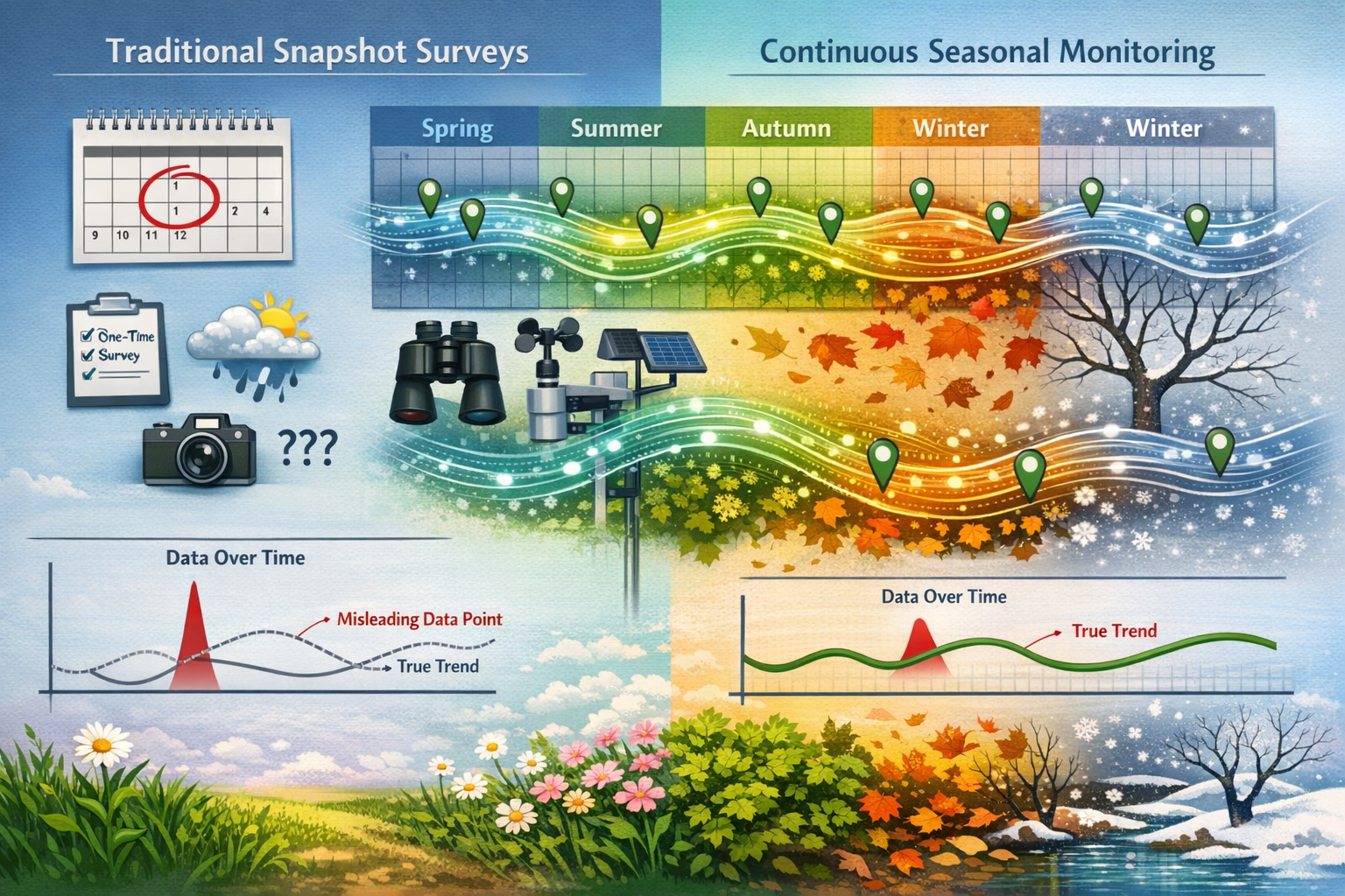
Weather-Driven Variation Masking True Trends
Traditional biodiversity surveys typically occur once per year, often timed to coincide with peak biological activity in summer months. While this approach seems logical—capturing maximum species diversity when most organisms are active—it introduces a critical vulnerability: confusing weather-driven fluctuations with genuine ecological change.
Consider a meadow surveyed during an unusually wet July. Amphibian populations might appear robust, wildflower diversity could seem exceptional, and insect abundance might register as healthy. Return to the same site during a drought year, and the numbers plummet. Without continuous monitoring across multiple seasons and years, surveyors cannot determine whether they're witnessing:
- Natural annual variation within a stable ecosystem
- Early warning signs of long-term decline
- Recovery signals following previous disturbance
- Weather anomalies that temporarily boost or suppress populations
Research demonstrates that one-off surveys risk mistaking weather-driven variation for long-term decline and short-term disturbance for recovery[1]. This isn't merely an academic concern—it has real-world consequences for development planning, Biodiversity Net Gain assessments, and conservation resource allocation.
Missing Critical Seasonal Windows
Biological activity concentrates dramatically during specific seasonal windows. Spring and summer are not just periods of high activity—they represent the reproductive, migratory, and developmental events that determine ecosystem viability[1].
A survey conducted in August might completely miss:
- 🌸 Early spring wildflower communities that bloom and set seed before summer species emerge
- 🐦 Spring migration patterns that reveal habitat connectivity and stopover site quality
- 🐸 Amphibian breeding aggregations that occur in temporary pools during March and April
- 🦇 Bat maternity colonies that form in May and disperse by late summer
- 🦋 Early-season pollinators essential for fruit set in native plant communities
Each of these biological events provides irreplaceable information about ecosystem function. Missing them doesn't just create data gaps—it fundamentally misrepresents the site's ecological value and conservation potential.
The Baseline Integrity Problem
Perhaps the most insidious flaw of snapshot surveys lies in their impact on baseline establishment. Every future comparison depends on the starting point of monitoring[1]. When data collection begins only when reporting pressure appears—such as during a planning application or after a disturbance event—the reference point is already compromised.
This creates a phenomenon ecologists call "shifting baseline syndrome": each generation of surveyors accepts the degraded state they first encounter as "normal," failing to recognize how far conditions have already declined from historical norms. By 2026, many ecosystems have experienced decades of gradual degradation. A snapshot survey conducted today might establish as "baseline" conditions that already represent significant biodiversity loss compared to conditions just 20 years ago.
Starting continuous biodiversity monitoring in 2026 offers a critical opportunity to establish robust baselines before further degradation becomes normalized[1]. These baselines serve as ecological anchors for all future assessments, Biodiversity Impact Assessments, and conservation interventions.
Continuous Biodiversity Monitoring in 2026: The Case for Full-Season Protocols
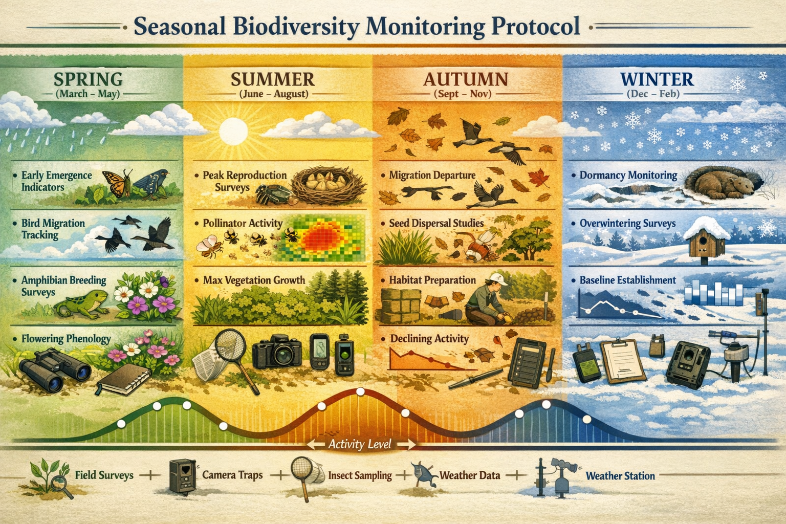
Capturing the Complete Biological Arc
Continuous Biodiversity Monitoring in 2026: Why Ecology Surveyors Must Shift from Snapshots to Seasonal Dynamics fundamentally rests on understanding ecosystems as dynamic systems rather than static inventories. Full-season monitoring protocols capture the complete biological arc from initial spring emergence through peak summer productivity and into autumn decline.
Starting monitoring in early spring provides several critical advantages[1]:
| Seasonal Phase | Key Biological Events | Monitoring Value |
|---|---|---|
| Early Spring (March-April) | Amphibian breeding, early flowering plants, spring migration arrival, hibernation emergence | Captures reproductive success indicators, habitat connectivity, overwintering survival rates |
| Late Spring (May-June) | Bird nesting, bat maternity colonies, peak flowering, insect emergence | Documents breeding populations, pollinator networks, predator-prey dynamics |
| Summer (July-August) | Peak vegetation growth, maximum species diversity, juvenile dispersal | Provides traditional survey data, captures productivity metrics, documents population recruitment |
| Autumn (September-October) | Migration departure, seed dispersal, habitat preparation, population decline | Reveals resource availability, documents successful reproduction, captures ecosystem resilience |
| Winter (November-February) | Dormancy, overwintering strategies, resident species, structural habitat features | Establishes baseline conditions, documents habitat quality, reveals year-round residents |
This comprehensive approach transforms biodiversity monitoring from a species checklist exercise into a true ecosystem function assessment. Rather than asking "what species are present?", continuous monitoring answers far more valuable questions:
- How do populations fluctuate across seasons?
- Which species interactions drive ecosystem stability?
- How quickly does the system respond to disturbance?
- Are observed changes cyclical or directional?
- What early warning signals precede population crashes?
Distinguishing Signal from Noise
One of the most powerful benefits of continuous monitoring is the ability to separate meaningful ecological signals from background noise. Natural ecosystems exhibit variation at multiple timescales:
Daily variation: Temperature, humidity, and light levels affect species detectability and activity patterns.
Weekly variation: Weather fronts, precipitation events, and lunar cycles influence behavior and movement.
Seasonal variation: Predictable annual cycles of reproduction, migration, dormancy, and resource availability.
Annual variation: Year-to-year differences in weather patterns, resource abundance, and population dynamics.
Decadal variation: Long-term climate trends, successional changes, and gradual environmental shifts.
Without continuous, multi-season data, surveyors cannot distinguish between these scales of variation[1]. A population decline observed during a single survey might represent:
- Normal seasonal migration (weekly-to-seasonal variation)
- Response to recent weather events (daily-to-weekly variation)
- Natural population cycles (annual variation)
- Genuine long-term decline requiring intervention (decadal variation)
Only continuous monitoring provides the temporal resolution to make these distinctions confidently. This capability is particularly crucial for achieving Biodiversity Net Gain targets, where demonstrating genuine ecological improvement requires separating intervention effects from background dynamics.
Building Robust Reference Datasets
Continuous monitoring in 2026 creates reference datasets that serve multiple purposes beyond immediate assessment needs:
✅ Regulatory compliance: Provides defensible evidence for planning applications and Biodiversity Net Gain reporting
✅ Intervention evaluation: Establishes pre-treatment conditions for assessing conservation action effectiveness
✅ Predictive modeling: Generates data for forecasting ecosystem responses to future changes
✅ Adaptive management: Enables evidence-based adjustments to management strategies
✅ Long-term research: Contributes to scientific understanding of ecosystem dynamics
These datasets become increasingly valuable over time. A continuous monitoring program started in 2026 will, by 2030, provide four years of seasonal data—enabling robust statistical analysis of trends, identification of tipping points, and confident attribution of observed changes to specific causes.
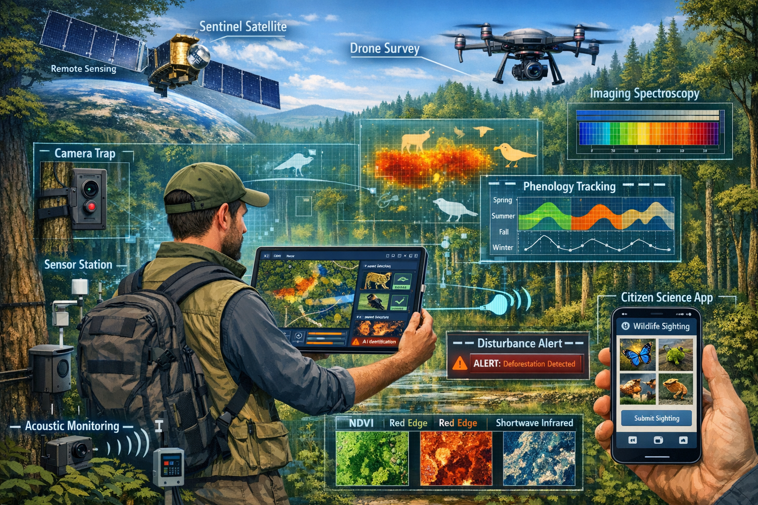
Technology Enabling Continuous Biodiversity Monitoring in 2026
Remote Sensing Revolution
The technological landscape for biodiversity monitoring has transformed dramatically in recent years. High-resolution satellite data from European Sentinel missions now enables capturing forest changes in great detail[2], providing continuous earth observation capabilities that complement traditional field surveys.
Remote sensing technologies offer several advantages for continuous monitoring:
🛰️ Temporal coverage: Satellites revisit sites every few days, capturing seasonal dynamics automatically
🛰️ Spatial scale: Entire landscapes can be monitored simultaneously, revealing patterns invisible at plot level
🛰️ Cost efficiency: Once systems are established, marginal costs for additional monitoring are minimal
🛰️ Objectivity: Automated sensors provide consistent, repeatable measurements free from observer bias
Recent advances include imaging spectroscopy to determine foliar chemistry, detect invasive species populations, and link spectral signatures to genetic diversity in tree species[3]. These capabilities enable surveyors to detect subtle changes in vegetation health, species composition, and ecosystem function that would be impossible to observe through traditional field surveys alone.
Particularly promising is the development of approaches like ROOT (mentioned for Bavarian forests), which enables spatially and temporally explicit quantification and visualization of forest disturbances in near real time using continuous processing with seasonal adjustment[2]. Such systems represent the future of biodiversity monitoring—combining automated detection with seasonal context to distinguish genuine disturbance from natural variation.
AI-Powered Species Detection
Artificial intelligence has revolutionized species detection and identification, making continuous monitoring feasible at scales previously unimaginable. Modern AI applications include:
Acoustic monitoring: Automated recording devices combined with AI algorithms can identify bird and bat species from vocalizations 24/7, capturing nocturnal species and rare calls that human observers would miss.
Camera trap analysis: Machine learning models process thousands of images automatically, identifying species, counting individuals, and documenting behavior patterns across seasons.
Environmental DNA (eDNA): Genetic sequencing of water, soil, or air samples reveals species presence without direct observation, enabling detection of rare or cryptic species.
Citizen science validation: Decentralized citizen science approaches increasingly generate validation data for AI applications, including species assessments, tree-mortality surveys, and automated species detection through apps like BirdNET[2].
These technologies don't replace professional ecologists—they amplify their capabilities. A single surveyor equipped with acoustic monitors, camera traps, and remote sensing data can monitor biodiversity continuously across multiple sites, gathering far richer datasets than traditional survey methods allow.
Integration Challenges and Solutions
Despite technological advances, a critical gap remains: functioning systems that promptly provide spatially and temporally explicit biodiversity information remain largely absent[2]. Comprehensive geoinformation products covering entire regions with updates multiple times per month are still needed.
Addressing this gap requires:
Data integration platforms: Systems that combine field observations, remote sensing data, citizen science contributions, and automated sensors into unified datasets.
Standardized protocols: Agreed-upon methods for data collection, quality control, and reporting that enable comparison across sites and time periods.
Accessible interfaces: User-friendly tools that allow ecology surveyors, planners, and developers to access and interpret continuous monitoring data without specialized technical expertise.
Quality assurance frameworks: Procedures for validating automated detections, calibrating sensors, and maintaining data integrity over long time periods.
Organizations working on Biodiversity Net Gain delivery are increasingly investing in these integration solutions, recognizing that continuous monitoring infrastructure provides competitive advantages in regulatory compliance and ecological outcomes.
Implementing Full-Season Monitoring Protocols: Practical Guidance
Designing Year-Round Survey Schedules
Implementing Continuous Biodiversity Monitoring in 2026: Why Ecology Surveyors Must Shift from Snapshots to Seasonal Dynamics requires thoughtful survey design that balances comprehensiveness with practical constraints.
Minimum viable continuous monitoring includes:
Early spring surveys (March-April): Focus on amphibian breeding, early flowering plants, spring migrant arrival, and signs of successful overwintering.
Late spring surveys (May-June): Document bird breeding activity, bat maternity colonies, peak flowering periods, and invertebrate emergence.
Summer surveys (July-August): Conduct traditional habitat and species inventories during peak diversity, document breeding success, and assess vegetation structure.
Autumn surveys (September-October): Observe migration departure, seed set and dispersal, habitat preparation for winter, and population recruitment.
Winter surveys (December-February): Establish structural baseline conditions, document overwintering species, and assess habitat quality during resource-limited periods.
This five-survey approach captures the full seasonal arc while remaining feasible for most projects. Each survey should include:
- Standardized habitat condition assessments
- Systematic species recording across multiple taxa
- Photographic documentation from fixed points
- Environmental condition recording (temperature, precipitation, phenology)
- Automated sensor deployment or data retrieval
Leveraging Automated Monitoring Tools
Continuous monitoring becomes truly powerful when field surveys are supplemented with automated data collection between visits:
Acoustic monitors: Deploy weatherproof recording devices that capture bird dawn choruses, bat activity, and amphibian calls throughout seasons. Modern devices can record continuously for months on single battery charges.
Camera traps: Position motion-activated cameras to document mammal activity, bird behavior, and seasonal habitat use patterns. AI-powered analysis tools can process thousands of images automatically.
Environmental sensors: Install temperature, humidity, and light loggers to document microclimate conditions that influence species activity and detectability.
Phenology cameras: Time-lapse cameras capturing daily images of vegetation reveal precise timing of leaf-out, flowering, fruiting, and senescence—critical indicators of ecosystem function.
These tools transform ecology surveyors from periodic observers into continuous monitoring coordinators, managing networks of sensors that gather data 24/7 across all seasons.
Data Management and Analysis Strategies
The shift to continuous monitoring generates vastly more data than traditional snapshot surveys. Effective data management requires:
Structured databases: Organize observations in standardized formats that enable temporal analysis, trend detection, and comparison across sites.
Version control: Maintain clear records of when data were collected, by whom, using what methods, ensuring reproducibility and quality assurance.
Visualization tools: Create graphs, charts, and maps that reveal seasonal patterns, highlight anomalies, and communicate trends to non-specialist audiences.
Statistical analysis: Apply appropriate methods for time-series data, accounting for seasonal variation, autocorrelation, and multiple testing issues.
Reporting frameworks: Develop templates that present continuous monitoring results clearly for planning applications, Biodiversity Net Gain assessments, and conservation evaluations.
Many ecology consultancies are investing in custom databases and analysis platforms specifically designed for continuous monitoring workflows, recognizing that data management infrastructure is as important as field survey skills.
Emerging Issues and Future Directions for Biodiversity Monitoring
The 2026 Global Horizon Scan Insights
The 2026 Global Horizon Scan, published in Trends in Ecology & Evolution, identifies 15 emerging issues for the decade ahead that underscore the urgency of continuous monitoring[4]. Key findings include:
Soil moisture decline affecting terrestrial ecosystems: Gradual drying trends may be invisible in snapshot surveys but become apparent through continuous soil moisture monitoring and vegetation health tracking.
Ocean darkening affecting marine productivity: Changes in water clarity and light penetration require continuous optical monitoring to detect and attribute causes.
Projected loss of macroalgal habitats like kelp forests: Seasonal monitoring reveals whether observed declines represent natural variation or directional change requiring intervention.
These emerging threats share a common characteristic: they manifest gradually through subtle seasonal shifts that only continuous monitoring can reliably detect. Snapshot surveys conducted annually might miss critical tipping points until ecosystems have already crossed thresholds into degraded states.
Climate Change and Phenological Shifts
Climate change is fundamentally altering the timing of biological events—a phenomenon called phenological shift. Spring arrives earlier, autumn extends later, and the synchrony between interdependent species (such as plants and their pollinators) becomes disrupted.
Continuous monitoring is essential for documenting these shifts because:
-
Timing changes are gradual: Phenological shifts of 2-3 days per decade are ecologically significant but easily missed in annual surveys.
-
Species respond differently: Some organisms advance their timing while others remain unchanged, creating mismatches that threaten ecosystem function.
-
Thresholds are non-linear: Ecosystems may appear stable for years before rapid transitions occur when critical phenological synchronies break down.
By establishing continuous monitoring in 2026, ecology surveyors create datasets that will reveal these phenological patterns over coming years, enabling proactive conservation interventions before ecosystem collapse occurs.
Integration with Biodiversity Net Gain Requirements
The implementation of Biodiversity Net Gain legislation creates both challenges and opportunities for continuous monitoring. Developers and planners increasingly recognize that:
Baseline assessments determine credit requirements: Robust continuous monitoring establishes defensible baselines that accurately quantify existing biodiversity value.
Intervention effectiveness must be demonstrated: Post-development monitoring must prove that enhancement measures deliver promised gains—requiring multi-season data to separate intervention effects from natural variation.
Long-term management requires adaptive strategies: Continuous monitoring enables evidence-based adjustments to management approaches, ensuring Biodiversity Net Gain targets are achieved and maintained over required 30-year periods.
Organizations offering biodiversity unit sales increasingly incorporate continuous monitoring into their service packages, recognizing that robust ecological data provides competitive advantages in demonstrating genuine biodiversity enhancement.
Overcoming Barriers to Continuous Monitoring Adoption
Addressing Cost Concerns
The most common objection to continuous monitoring is perceived cost. However, this concern often reflects incomplete cost-benefit analysis:
Traditional snapshot surveys carry hidden costs:
- Risk of regulatory rejection due to inadequate baseline data
- Potential for failed interventions due to poor understanding of ecosystem dynamics
- Liability exposure from inaccurate biodiversity assessments
- Opportunity costs from missed conservation priorities
Continuous monitoring provides multiple value streams:
- Reduced risk of planning delays or rejections
- Higher confidence in intervention effectiveness
- Marketable datasets valuable for research and education
- Competitive advantages in demonstrating environmental responsibility
When total lifecycle costs are considered—including risks, opportunities, and long-term value—continuous monitoring often proves more cost-effective than repeated snapshot surveys.
Furthermore, technology is rapidly reducing monitoring costs. Acoustic monitors that cost thousands of pounds five years ago are now available for hundreds. AI-powered analysis that required specialized expertise is increasingly automated. Remote sensing data that was proprietary is now freely available through programs like Copernicus.
Building Organizational Capacity
Shifting from snapshot to continuous monitoring requires new skills and systems:
Technical skills: Ecology surveyors need training in sensor deployment, data management, statistical analysis of time-series data, and remote sensing interpretation.
Infrastructure: Organizations need databases, analysis platforms, and reporting systems designed for continuous data streams.
Cultural change: Teams must shift from project-based thinking to program-based approaches, viewing monitoring as ongoing rather than episodic.
Collaboration: Effective continuous monitoring often requires partnerships between ecologists, data scientists, technology specialists, and land managers.
Professional development opportunities, including workshops on continuous monitoring methods, are increasingly available through ecological professional societies and specialized consultancies.
Regulatory Alignment and Standardization
For continuous monitoring to become standard practice, regulatory frameworks must evolve to recognize and reward comprehensive temporal data. This includes:
Updated guidance: Planning authorities should specify continuous monitoring expectations in Biodiversity Net Gain guidance for developers.
Standardized protocols: Industry-wide agreement on minimum monitoring frequencies, methods, and reporting formats enables comparison and quality assurance.
Credit mechanisms: Biodiversity metric calculations should explicitly value robust baseline data from continuous monitoring over snapshot surveys.
Validation requirements: Post-development monitoring requirements should mandate multi-season verification of claimed biodiversity gains.
Progress is occurring: recent secondary BNG legislation increasingly emphasizes monitoring quality and temporal coverage, creating regulatory drivers for continuous approaches.
Conclusion: The Imperative for Continuous Biodiversity Monitoring in 2026
The evidence is overwhelming: snapshot surveys are no longer adequate for the biodiversity challenges facing ecosystems in 2026. As climate change accelerates, regulatory requirements intensify, and conservation resources remain limited, ecology surveyors must embrace continuous, multi-season monitoring approaches that capture the full complexity of ecosystem dynamics.
Continuous Biodiversity Monitoring in 2026: Why Ecology Surveyors Must Shift from Snapshots to Seasonal Dynamics represents more than a methodological improvement—it's a fundamental reconceptualization of how we understand, assess, and protect biodiversity. By monitoring ecosystems across complete seasonal cycles, starting in early spring and continuing through winter, surveyors can:
✅ Distinguish genuine ecological trends from weather-driven noise
✅ Capture critical biological events that define ecosystem health and function
✅ Establish robust baselines before further degradation becomes normalized
✅ Demonstrate intervention effectiveness with confidence and precision
✅ Detect early warning signals enabling proactive conservation responses
The technological tools exist. Remote sensing platforms provide continuous earth observation. AI-powered species detection automates data collection. Affordable sensors gather information 24/7. What's needed now is commitment from ecology professionals, support from regulatory authorities, and recognition from developers and planners that continuous monitoring delivers superior ecological and economic outcomes.
Actionable Next Steps
For ecology surveyors and environmental consultancies:
- Audit current monitoring protocols to identify seasonal gaps and opportunities for continuous data collection
- Invest in training on remote sensing, automated monitoring tools, and time-series data analysis
- Pilot continuous monitoring programs on selected sites to build experience and demonstrate value
- Develop data management infrastructure capable of handling continuous data streams
- Communicate benefits to clients, emphasizing risk reduction and regulatory advantages
For developers and planners:
- Request continuous monitoring in Biodiversity Impact Assessments and baseline surveys
- Allocate budgets that reflect the value of robust temporal data over snapshot surveys
- Incorporate seasonal monitoring into project timelines, starting surveys in early spring
- Require multi-season verification of post-development biodiversity outcomes
- Partner with consultancies experienced in continuous monitoring approaches
For regulatory authorities and policymakers:
- Update guidance documents to specify continuous monitoring expectations
- Develop standardized protocols for multi-season biodiversity assessment
- Create incentives that reward comprehensive temporal data in planning decisions
- Support research into cost-effective continuous monitoring methods
- Facilitate data sharing to build regional and national biodiversity monitoring networks
The shift from snapshots to seasonal dynamics is not optional—it's essential for effective biodiversity conservation in an era of rapid environmental change. By embracing continuous monitoring in 2026, the ecology profession can establish the robust ecological understanding needed to reverse biodiversity decline and create genuinely sustainable development outcomes.
The ecosystems we seek to protect don't pause for our convenience. It's time our monitoring approaches reflected the dynamic reality of the natural world.
References
[1] Why Monitor Biodiversity In 2026 – https://evolito.earth/stories/why-monitor-biodiversity-in-2026
[2] Continuous Earth Observation Of Forest Dynamics And Biodiversity – https://cacm.acm.org/sustainability-and-computing/continuous-earth-observation-of-forest-dynamics-and-biodiversity/
[3] Webinar Remote Sensing For Biodiversity Monitoring – https://www.biodiversa.eu/2025/11/05/webinar-remote-sensing-for-biodiversity-monitoring/
[4] Whats Next For Biodiversity Conservation Insights From The 2026 Horizon Scan – https://www.unep-wcmc.org/en/news/whats-next-for-biodiversity-conservation-insights-from-the-2026-horizon-scan
