
The natural world stands at a critical crossroads in 2026. As ecologists venture into forests, wetlands, and coastal zones to document biodiversity, they face challenges that previous generations never imagined. Ocean darkening threatens marine food webs in ways scientists are only beginning to understand. Tiny machine learning devices promise to revolutionize how field teams collect data in the most remote corners of Earth. Meanwhile, appetite-suppressing pharmaceuticals are reshaping global food demand patterns with cascading effects on land use and conservation priorities.
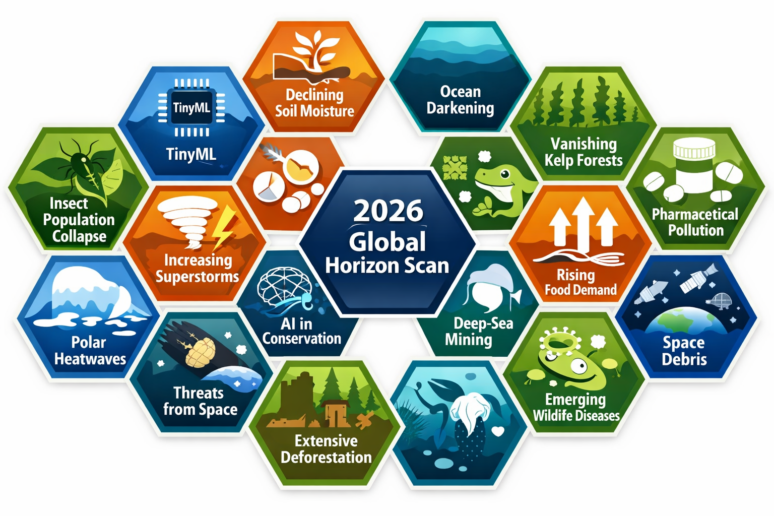
The 17th annual Global Horizon Scan for biological conservation has identified 15 emerging issues that will fundamentally reshape how ecology surveys are conducted, analyzed, and applied to real-world conservation decisions[1][3]. Leveraging the 2026 Global Horizon Scan for Ecology Surveys: Key Emerging Issues and Field Strategies provides ecologists, conservation practitioners, and environmental planners with a roadmap for navigating these unprecedented challenges and opportunities.
Coordinated by the Cambridge Conservation Initiative and partially funded by The Pew Charitable Trusts, this year's horizon scan involved 26 international scientists, practitioners, and policymakers who screened 96 potential issues before identifying the 15 most critical topics[3][5]. Published in Trends in Ecology & Evolution in January 2026, these findings offer actionable insights for professionals working at the intersection of biodiversity assessment, land management, and environmental policy[1][2].
Key Takeaways
- 🔬 TinyML devices and optical AI chips enable real-time biodiversity detection in remote areas without internet connectivity, transforming field survey capabilities
- 🌊 Ocean darkening and kelp forest loss represent critical marine ecosystem threats requiring immediate integration into coastal ecology surveys
- 🌱 Soil moisture decline affects terrestrial and freshwater ecosystems globally, necessitating updated baseline data collection protocols
- 💊 Pharmaceutical-driven food demand shifts create unexpected land-use changes that ecology surveys must account for
- 📊 Equitable technology access remains essential for ensuring conservation benefits reach communities with varying digital infrastructure
Understanding the 2026 Global Horizon Scan Framework
The horizon scanning process represents one of the most rigorous early-warning systems in conservation science. Each year, an international panel identifies emerging issues that could significantly impact biological diversity but have not yet received widespread attention in the conservation community[3].
The Selection Process
The 2026 scan followed a structured methodology:
- Initial Screening: Participants proposed 96 potential issues based on recent scientific literature, policy developments, and field observations
- Ranking Workshop: The 35 highest-ranked issues were discussed in detail during a collaborative workshop
- Final Selection: The panel identified 15 top-ranked issues based on potential impact, novelty, and actionability[3]
This systematic approach ensures that the selected issues represent genuinely emerging threats and opportunities rather than well-established conservation challenges.
Why Horizon Scans Matter for Field Ecologists
For professionals conducting biodiversity impact assessments, horizon scans provide critical foresight. They highlight:
- New monitoring technologies that could improve survey accuracy
- Environmental changes requiring updated baseline data
- Policy shifts affecting conservation priorities
- Socioeconomic trends influencing land-use patterns
By integrating these insights into survey design, ecologists can collect data that remains relevant for years to come, supporting adaptive management strategies and evidence-based conservation decisions.
Leveraging the 2026 Global Horizon Scan: Technology-Driven Survey Innovations
TinyML Devices: Revolutionizing Remote Biodiversity Detection
Perhaps the most transformative issue identified in the 2026 scan involves low-power Tiny Machine Learning (TinyML) devices and optical AI chips[2]. These technologies could fundamentally change how ecology surveys are conducted in remote landscapes.
What Makes TinyML Different?
Traditional biodiversity monitoring tools often require:
- Constant internet connectivity for data transmission
- High energy consumption necessitating frequent battery changes
- Complex setup procedures requiring specialized training
- Expensive equipment limiting deployment scale
TinyML devices address these limitations by:
✅ Operating completely offline without internet requirements
✅ Running on minimal power for months or years
✅ Performing real-time species identification in the field
✅ Costing significantly less than traditional monitoring systems
Practical Applications for Ecology Surveys
Field teams can leverage TinyML technology in several ways:
Acoustic Monitoring: Deploy devices that identify bird, bat, and amphibian species through call recognition, automatically logging detections without requiring manual review of thousands of hours of recordings.
Camera Trap Analysis: Use optical AI chips to process images on-device, identifying species immediately and only transmitting confirmed detections rather than thousands of empty frames.
Insect Surveys: Implement automated identification systems for pollinators and other invertebrates, dramatically increasing sample sizes while reducing identification time.
Vegetation Assessment: Apply machine vision to identify plant species and assess habitat condition through automated image analysis.
Addressing Technology Equity Concerns
While TinyML offers tremendous potential, the 2026 scan raises important questions about equitable access[2]. Conservation benefits must reach users across varying levels of digital infrastructure. Field strategies should include:
- Open-source platforms that allow customization for local species and conditions
- Training programs ensuring diverse practitioners can deploy and maintain systems
- Data governance frameworks addressing ownership and access transparency
- Energy audits confirming that "low-power" claims translate to genuine sustainability improvements
For organizations implementing Biodiversity Net Gain assessments, TinyML could provide the long-term monitoring data needed to verify habitat creation success and track biodiversity uplift over time.
Critical Environmental Changes Reshaping Survey Protocols
Soil Moisture Decline: A Global Terrestrial Threat
The 2026 horizon scan identifies widespread soil moisture decline as a growing pressure on terrestrial and freshwater ecosystems[2]. This issue carries profound implications for:
- Food production systems and agricultural landscapes
- Biodiversity persistence in water-limited habitats
- Water security for human and ecological communities
- Carbon storage in soil organic matter
Survey Strategy Adjustments:
Field ecologists should integrate soil moisture monitoring into baseline assessments, particularly for:
| Habitat Type | Key Considerations | Monitoring Frequency |
|---|---|---|
| Grasslands | Drought-sensitive species shifts | Quarterly during growing season |
| Wetlands | Hydroperiod changes affecting amphibians | Monthly year-round |
| Forests | Tree stress and mortality patterns | Biannual with event-triggered surveys |
| Agricultural edges | Buffer zone effectiveness | Pre- and post-growing season |
Soil moisture data provides context for interpreting species distribution changes. What appears to be habitat degradation might actually reflect climate-driven moisture availability shifts requiring different conservation responses.
Ocean Darkening: The Marine Visibility Crisis
Ocean darkening—declining light penetration across wide ocean regions—represents one of the least understood threats identified in the 2026 scan[2]. This phenomenon could substantially affect:
- Marine primary productivity
- Food web dynamics
- Fish behavior and distribution
- Coral reef health
Mechanisms Driving Ocean Darkening:
🌊 Increased sediment runoff from coastal development
🌊 Algal blooms triggered by nutrient pollution
🌊 Microplastic accumulation affecting light transmission
🌊 Climate-driven changes in ocean mixing patterns
Field Survey Implications:
Marine ecologists conducting coastal surveys should:
- Document baseline light conditions using affordable light meters at standard depths
- Record water clarity through Secchi disk measurements during each survey
- Photograph underwater habitats to create visual records of changing light environments
- Correlate species observations with light availability data to identify threshold effects
This data becomes particularly valuable for Biodiversity Net Gain planning, where coastal development projects must demonstrate no net loss of marine biodiversity despite potential light pollution and sediment impacts.
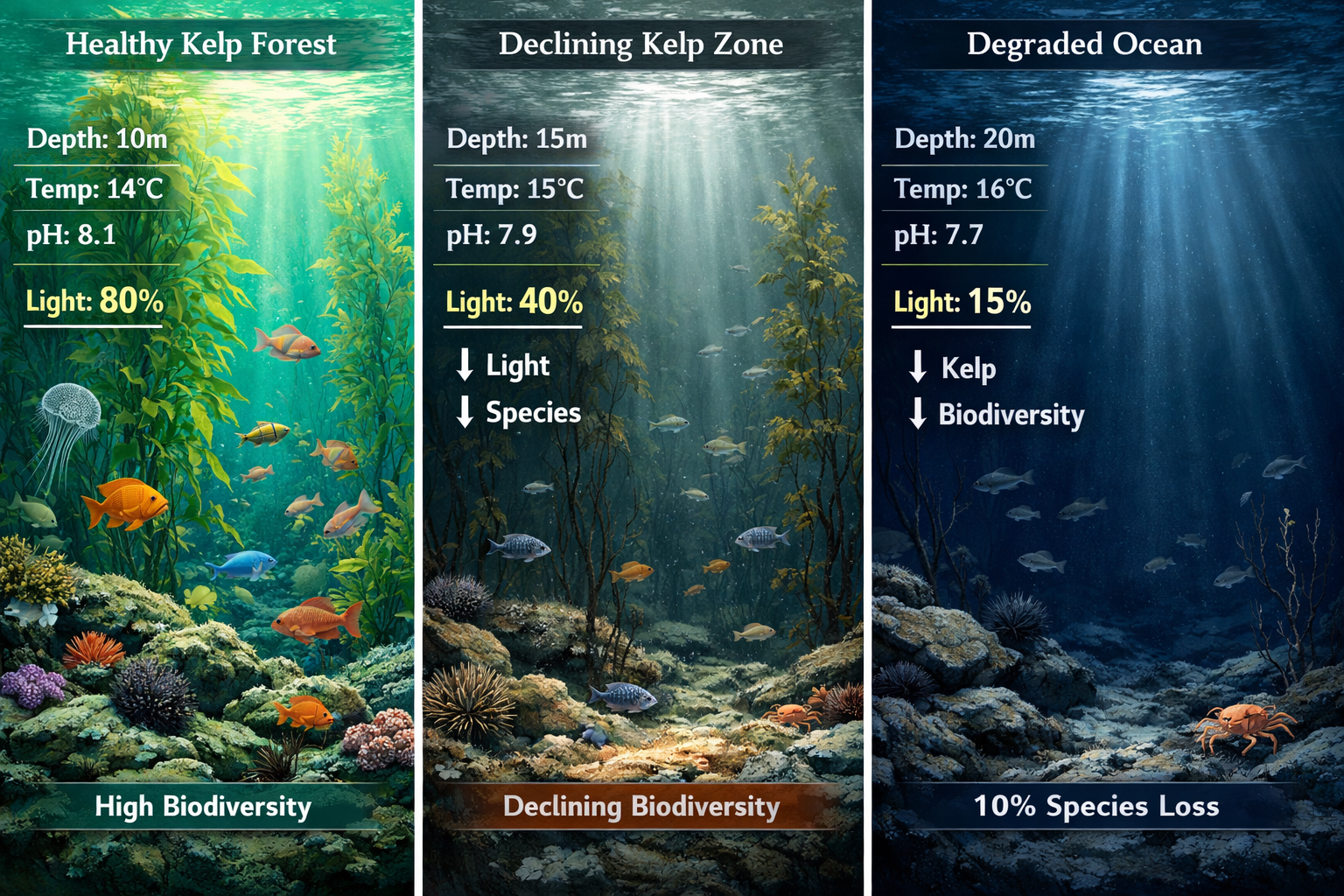
Macroalgal Habitat Loss: Kelp Forest Collapse
The loss of macroalgal habitats, including kelp forests, highlights coastal ecosystem vulnerability to warming and extreme events[2][5]. Climate models project alarming trends:
- Some regions will lose more than 10% of seaweed species by century's end
- Only polar regions are expected to see kelp gains
- Cascading effects will impact fish nurseries and carbon sequestration
Survey Adaptations for Kelp Monitoring:
Traditional kelp surveys focused on biomass and extent. The 2026 horizon scan suggests expanding protocols to include:
Thermal Stress Indicators: Document bleaching events, tissue degradation, and reproductive failure linked to marine heatwaves.
Species Composition Shifts: Track replacement of cold-water kelp species with warm-water algae, noting functional differences in habitat provision.
Associated Fauna Changes: Monitor fish, invertebrate, and marine mammal communities dependent on kelp structure.
Recovery Potential: Assess spore banks and recruitment patterns to predict restoration feasibility.
For professionals working on coastal development projects, understanding kelp vulnerability is essential for designing effective mitigation and compensation measures.
Leveraging the 2026 Global Horizon Scan: Socioeconomic Drivers and Land-Use Implications
Pharmaceutical-Driven Food Demand Shifts
One of the most unexpected issues in the 2026 scan involves appetite-suppressing pharmaceuticals driving changes in land-use patterns[3]. As these medications become more widely prescribed and adopted, they could trigger:
Reduced Agricultural Demand: Lower food consumption may decrease pressure on agricultural expansion, potentially creating conservation opportunities.
Dietary Pattern Changes: Shifts away from calorie-dense foods could alter which crops are grown and where, affecting associated biodiversity.
Livestock Sector Impacts: Reduced meat consumption could free grazing lands for restoration or alternative uses.
Unexpected Consequences: Changes in food waste, supply chain dynamics, and international trade patterns may create novel conservation challenges.
Field Survey Considerations
Ecologists conducting surveys in agricultural landscapes should:
- Establish land-use baselines documenting current agricultural intensity and crop types
- Monitor abandonment patterns in areas where agricultural pressure decreases
- Track spontaneous vegetation recovery on formerly cultivated lands
- Assess colonization rates for native species in transitional habitats
This information supports strategic biodiversity planning by identifying where natural habitat recovery might occur without active intervention, allowing conservation resources to focus on areas requiring restoration investment.
Global Food Demand as a Conservation Driver
Beyond pharmaceutical effects, the 2026 scan identifies broader shifts in global food demand as a major driver reshaping biodiversity conservation priorities[1][2]. These include:
- Plant-based protein adoption rates
- Cellular agriculture development
- Climate-driven crop suitability changes
- Food security policy responses
Integration with Biodiversity Net Gain:
For developers and planners working with Biodiversity Net Gain requirements, understanding food demand trends helps identify:
- Off-site habitat creation opportunities on transitioning agricultural land
- Biodiversity unit market dynamics as land values shift
- Long-term habitat security considerations for 30-year management plans
- Partnership opportunities with agricultural landowners exploring alternative income streams
The guidance for landowners considering biodiversity unit creation should account for these emerging trends when evaluating long-term land management options.
Implementing Horizon Scan Insights: Practical Field Strategies for 2026
Strategy 1: Adaptive Survey Design
Traditional ecology surveys often follow standardized protocols developed years or decades ago. Leveraging the 2026 Global Horizon Scan for Ecology Surveys: Key Emerging Issues and Field Strategies requires more adaptive approaches:
Build Flexibility into Protocols: Design surveys that can accommodate new monitoring technologies as they become available, rather than locking into specific equipment or methods.
Include Emerging Indicators: Add measurements for horizon scan issues (soil moisture, light penetration, thermal stress) even if they're not primary survey targets.
Plan for Technology Integration: Reserve budget and training time for adopting tools like TinyML devices as they mature and become field-ready.
Document Baseline Conditions: Collect data on emerging issues now, before changes become severe, establishing reference points for future comparisons.
Strategy 2: Multi-Stressor Assessments
The 2026 horizon scan reveals that ecosystems face multiple simultaneous pressures. Single-issue surveys miss critical interactions:
Example Multi-Stressor Framework:
A coastal development ecology survey might assess:
- Direct habitat loss from construction footprint
- Ocean darkening from increased sediment runoff
- Kelp forest vulnerability to warming and extreme events
- Light pollution affecting marine species behavior
- Noise impacts on marine mammals and fish
This comprehensive approach supports more accurate biodiversity impact assessments and identifies mitigation measures addressing cumulative effects rather than isolated impacts.
Strategy 3: Data Sharing and Collaboration
The horizon scan's emphasis on equitable technology access extends to data sharing. Field strategies should include:
Open Data Commitments: Share survey results through accessible platforms, contributing to regional and global biodiversity databases.
Standardized Formats: Use common data standards enabling integration with other datasets and long-term monitoring programs.
Collaborative Networks: Participate in practitioner communities sharing experiences with emerging technologies and methodologies.
Capacity Building: Support training initiatives helping diverse practitioners adopt new survey approaches.
Strategy 4: Future-Proofing Conservation Recommendations
Survey reports typically include management recommendations. Incorporating horizon scan insights ensures these remain relevant:
Scenario Planning: Present multiple management pathways accounting for different trajectories of emerging issues (e.g., rapid vs. gradual soil moisture decline).
Adaptive Management Triggers: Define monitoring thresholds that would prompt management strategy adjustments as conditions change.
Technology Adoption Roadmaps: Outline how new monitoring tools could enhance long-term habitat management and verification.
Climate Resilience: Prioritize conservation actions supporting ecosystem adaptation to changing conditions rather than attempting to maintain static baselines.
For small development projects implementing Biodiversity Net Gain, these forward-looking recommendations help ensure habitat creation remains effective throughout the 30-year management period.
Integrating Horizon Scan Issues with Biodiversity Net Gain
The intersection of emerging ecological issues and regulatory frameworks like Biodiversity Net Gain creates both challenges and opportunities. Understanding why Biodiversity Net Gain is important to the UK helps contextualize how horizon scan insights can strengthen implementation.
Enhanced Baseline Assessments
BNG requires accurate baseline biodiversity assessments. Horizon scan issues suggest expanding these to include:
Technology-Enhanced Surveys: Using TinyML devices for more comprehensive species inventories, particularly for difficult-to-survey taxa like bats, nocturnal species, and cryptic invertebrates.
Climate Vulnerability Indicators: Documenting soil moisture, thermal stress, and other factors affecting habitat condition and species persistence.
Long-Term Viability Metrics: Assessing whether proposed habitat creation sites face emerging threats like ocean darkening or macroalgal loss that could undermine biodiversity outcomes.
Improved Habitat Creation Planning
The 2026 horizon scan informs where and how to create biodiversity units:
Opportunity Mapping: Identifying agricultural lands transitioning due to food demand shifts as potential off-site biodiversity unit creation locations.
Climate-Adapted Habitats: Designing created habitats accounting for soil moisture decline, selecting drought-tolerant species and water-retention features.
Monitoring Technology: Incorporating TinyML and other emerging tools into 30-year management plans, reducing long-term monitoring costs while improving data quality.
Risk Assessment: Evaluating how emerging issues might affect habitat creation success, supporting risk-aware BNG planning.
Strategic Unit Purchasing and Creation
For developers evaluating whether to buy biodiversity units or create on-site habitat, horizon scan insights provide additional decision-making criteria:
Off-Site Advantages: Professional habitat creation sites may more readily adopt emerging monitoring technologies and adaptive management approaches informed by horizon scan issues.
On-Site Opportunities: Smaller-scale habitat creation can pilot innovative approaches to climate resilience and technology integration.
Landowner Considerations: Those looking to sell biodiversity units can differentiate offerings by demonstrating adoption of best practices addressing emerging conservation issues.
Regional and Habitat-Specific Applications
Terrestrial Ecosystems
Forests and Woodlands:
- Monitor soil moisture to predict drought stress and species composition shifts
- Deploy TinyML acoustic monitors for comprehensive bird and bat surveys
- Track canopy health indicators related to climate stress
- Document seed bank viability under changing moisture regimes
Grasslands and Heathlands:
- Assess vulnerability to soil moisture decline through indicator species monitoring
- Use automated insect identification for pollinator surveys
- Evaluate grazing regime sustainability under changing precipitation patterns
- Monitor spontaneous vegetation changes on transitioning agricultural lands
Wetlands:
- Document hydroperiod changes linked to soil moisture decline
- Assess amphibian breeding success under altered water availability
- Monitor vegetation community shifts toward drought-tolerant species
- Evaluate wetland creation site suitability accounting for climate projections
Marine and Coastal Ecosystems
Rocky Shores and Kelp Forests:
- Establish baseline light penetration measurements for ocean darkening detection
- Monitor kelp species composition shifts toward warm-water taxa
- Document thermal stress events and recovery patterns
- Assess fish and invertebrate community changes linked to macroalgal loss
Estuaries and Coastal Wetlands:
- Track sediment loading effects on light availability
- Monitor saltmarsh migration potential under sea-level rise
- Assess bird community responses to changing food availability
- Document interaction effects between multiple stressors
Offshore Waters:
- Conduct light penetration surveys at standard depths
- Monitor phytoplankton community composition changes
- Assess food web effects of ocean darkening
- Track mobile species distribution shifts
Agricultural Landscapes
Arable Farmland:
- Monitor field margin biodiversity on transitioning lands
- Assess spontaneous habitat recovery rates
- Track dietary shift effects on crop selection and biodiversity
- Document pollinator populations under changing agricultural intensity
Pastoral Systems:
- Evaluate grazing pressure changes linked to food demand shifts
- Monitor grassland biodiversity responses to reduced livestock density
- Assess opportunities for habitat restoration on depastured lands
- Track soil moisture impacts on forage quality and wildlife habitat
Training and Capacity Building for Emerging Issues
Successfully leveraging the 2026 Global Horizon Scan for Ecology Surveys: Key Emerging Issues and Field Strategies requires investment in professional development:
Essential Skills for 2026 and Beyond
Technology Literacy: Understanding TinyML capabilities, limitations, and appropriate applications; evaluating new monitoring tools critically rather than adopting technology for its own sake.
Climate Science Integration: Interpreting climate projections and translating them into practical survey design adjustments; recognizing climate-driven ecological changes versus other stressors.
Data Science Fundamentals: Managing and analyzing larger datasets generated by automated monitoring; applying machine learning validation protocols to ensure accuracy.
Interdisciplinary Collaboration: Working effectively with technology developers, climate scientists, social scientists, and policy experts; communicating across disciplinary boundaries.
Adaptive Management: Designing monitoring programs that inform management adjustments; building feedback loops between data collection and conservation action.
Professional Development Resources
Ecology professionals can build capacity through:
- Webinars and workshops on emerging monitoring technologies
- Field trials testing new equipment in local conditions
- Peer learning networks sharing experiences with horizon scan issues
- Academic partnerships accessing cutting-edge research and methods
- Industry conferences exploring technology applications and case studies
Organizations conducting ecology surveys should allocate professional development budgets specifically for emerging issues, ensuring teams remain current with best practices.
Policy and Regulatory Considerations
Informing Conservation Policy
Horizon scan findings should influence policy development at multiple scales:
National Conservation Strategy: Prioritizing research funding and conservation programs addressing emerging high-impact issues.
Planning Policy: Updating development assessment requirements to account for cumulative effects of emerging stressors.
Protected Area Management: Adapting management plans to address new threats and opportunities identified in horizon scans.
International Agreements: Informing biodiversity convention negotiations with early warning of transboundary issues.
Biodiversity Net Gain Evolution
As BNG implementation matures, horizon scan insights can drive policy refinement:
Metric Updates: Incorporating emerging issues into condition assessment criteria and biodiversity unit calculations.
Monitoring Requirements: Mandating consideration of horizon scan issues in long-term management plans.
Risk Assessment: Requiring developers to evaluate how emerging threats might affect proposed habitat creation.
Technology Standards: Developing protocols for TinyML and other emerging monitoring tools in BNG verification.
For planners seeking to understand 8 key things about Biodiversity Net Gain, staying informed about horizon scan developments ensures regulatory compliance and best practice alignment.
Case Studies: Applying Horizon Scan Insights
Case Study 1: Coastal Development with Ocean Darkening Considerations
Project: Mixed-use development on previously industrial coastal site
Challenge: Standard marine ecology survey identified kelp forest and seagrass beds within potential impact zone, but didn't account for ocean darkening vulnerability.
Horizon Scan Application:
- Added light penetration monitoring to baseline surveys
- Assessed existing sediment loading and water clarity trends
- Evaluated kelp species composition for climate vulnerability
- Designed mitigation measures addressing both direct impacts and ocean darkening
Outcome: Enhanced mitigation strategy included sediment control measures exceeding standard requirements, offshore kelp restoration in less vulnerable locations, and TinyML-based long-term monitoring verifying effectiveness.
Case Study 2: Agricultural Estate Biodiversity Unit Creation
Project: Landowner converting marginal arable land to species-rich grassland for biodiversity unit creation
Challenge: Standard habitat creation plan didn't account for soil moisture decline projections or food demand shift implications.
Horizon Scan Application:
- Incorporated soil moisture monitoring into baseline assessment
- Selected drought-tolerant seed mixes appropriate for projected conditions
- Designed water retention features (swales, ponds) enhancing resilience
- Evaluated long-term market demand for units given agricultural transition trends
Outcome: Climate-adapted habitat creation plan with enhanced marketability to developers seeking robust, long-term biodiversity outcomes; TinyML insect monitoring demonstrating rapid colonization success.
Case Study 3: Forest Management with Technology Integration
Project: Ancient woodland restoration and enhancement
Challenge: Limited budget for comprehensive species surveys; uncertainty about climate change effects on woodland composition.
Horizon Scan Application:
- Deployed low-cost TinyML acoustic monitors throughout woodland
- Collected soil moisture data at representative locations
- Monitored canopy health indicators for drought stress
- Used automated analysis to track bird and bat populations
Outcome: Comprehensive biodiversity data at fraction of traditional survey costs; early detection of drought-stressed tree species informing adaptive management; robust evidence base for conservation value supporting protective designation.
Future Directions and Research Needs
While the 2026 horizon scan provides valuable foresight, significant knowledge gaps remain:
Priority Research Questions
Technology Validation: How accurate are TinyML species identifications across different taxa and environments? What validation protocols ensure reliability?
Ocean Darkening Mechanisms: What are the primary drivers in different regions? How quickly is the phenomenon progressing? What are the ecological threshold effects?
Soil Moisture Impacts: How do different species and communities respond to moisture decline? What are the critical thresholds for biodiversity loss?
Kelp Forest Resilience: Which species and locations show greatest climate resilience? What restoration approaches work under changing conditions?
Food System Transitions: How rapidly will pharmaceutical and dietary shifts affect land use? What are the regional variations and conservation implications?
Monitoring Network Development
Addressing these questions requires coordinated monitoring efforts:
- Standardized protocols enabling data comparison across sites and regions
- Technology testing networks validating emerging tools in diverse conditions
- Long-term monitoring sites tracking horizon scan issues over time
- Data synthesis platforms integrating findings from multiple sources
Ecology practitioners can contribute by sharing data, participating in validation studies, and documenting experiences with emerging issues and technologies.
Conclusion: Actionable Steps for Ecology Professionals
Leveraging the 2026 Global Horizon Scan for Ecology Surveys: Key Emerging Issues and Field Strategies requires proactive engagement from the entire conservation community. The 15 emerging issues identified by international experts represent both challenges and opportunities for those conducting biodiversity assessments, managing habitats, and informing conservation policy[1][2][3].
Immediate Actions for Field Ecologists
1. Review Current Survey Protocols: Evaluate whether existing methods capture data relevant to horizon scan issues. Identify opportunities to add measurements for soil moisture, light penetration, thermal stress, and other emerging indicators.
2. Explore Technology Pilots: Investigate TinyML and optical AI chip applications for current projects. Start small with pilot deployments, learning capabilities and limitations before large-scale adoption.
3. Build Climate Awareness: Integrate climate projections into survey design and conservation recommendations. Consider how emerging issues might affect the ecosystems being assessed over 5, 10, and 30-year timeframes.
4. Enhance Data Sharing: Commit to making survey data accessible through appropriate platforms. Contribute to the collective knowledge base supporting adaptive conservation responses.
5. Invest in Professional Development: Allocate time and resources for learning about emerging issues, new technologies, and evolving best practices. Participate in training opportunities and professional networks.
Strategic Recommendations for Organizations
For Developers and Planners: Incorporate horizon scan insights into biodiversity impact assessments and Biodiversity Net Gain planning. Evaluate how emerging issues affect proposed habitat creation, mitigation effectiveness, and long-term biodiversity outcomes.
For Landowners: Consider how food demand shifts and agricultural transitions create opportunities for biodiversity unit creation. Assess land suitability accounting for climate resilience and emerging monitoring technologies.
For Conservation Organizations: Prioritize research and management actions addressing high-impact horizon scan issues. Develop capacity-building programs helping practitioners adopt new approaches and technologies.
For Policy Makers: Use horizon scan findings to inform conservation strategy, planning policy, and regulatory framework evolution. Ensure assessment requirements keep pace with emerging science and best practices.
The Path Forward
The 2026 Global Horizon Scan demonstrates that conservation challenges continue to evolve in unexpected ways. Ocean darkening, TinyML devices, pharmaceutical-driven land-use changes, and soil moisture decline were not major conservation topics a decade ago. Yet they now represent critical issues requiring immediate attention and integration into ecology surveys and conservation planning.
Success requires adaptability, collaboration, and commitment to evidence-based practice. By leveraging the insights provided by horizon scanning processes, ecology professionals can ensure their work remains relevant, rigorous, and effective in addressing the biodiversity crisis.
The emerging issues identified in 2026 will shape conservation practice for years to come. Those who engage proactively with these challenges—adopting new technologies thoughtfully, monitoring emerging threats systematically, and adapting strategies based on evidence—will be best positioned to deliver meaningful biodiversity outcomes in an uncertain future.
Start today: Review the 15 issues from the 2026 horizon scan, identify which are most relevant to your work, and take concrete steps to integrate them into your next ecology survey or conservation project. The natural world cannot wait for perfect information or ideal conditions. It needs practitioners willing to work with emerging knowledge, embrace innovation, and adapt as understanding evolves.
For additional guidance on implementing best practices in biodiversity assessment and conservation planning, explore our comprehensive resources on Biodiversity Net Gain, ecology surveys, and habitat management strategies.
References
[1] A Horizon Scan Of Biological Conservation Issues For 2026 – https://www.besnet.world/library/a-horizon-scan-of-biological-conservation-issues-for-2026/
[2] Whats Next For Biodiversity Conservation Insights From The 2026 Horizon Scan – https://www.unep-wcmc.org/en/news/whats-next-for-biodiversity-conservation-insights-from-the-2026-horizon-scan
[3] pubmed.ncbi.nlm.nih.gov – https://pubmed.ncbi.nlm.nih.gov/41339143/
[5] New Conservation Opportunities And Obstacles In A New Year – https://www.pew.org/en/research-and-analysis/articles/2026/01/16/new-conservation-opportunities-and-obstacles-in-a-new-year
