
The traditional approach to biodiversity assessment—conducting surveys during a single optimal season—is rapidly becoming obsolete in 2026. As ecology surveyors face increasing pressure to deliver accurate Biodiversity Net Gain (BNG) calculations, Full-Season Biodiversity Monitoring: Shifting from Snapshots to Continuous Dynamics for 2026 Net Gain Accuracy has emerged as the gold standard for capturing the true ecological value of development sites. Single-day surveys miss critical seasonal variations, migratory patterns, and temporal dynamics that fundamentally shape habitat quality and species richness.
This comprehensive guide provides ecology surveyors with actionable protocols to implement year-round monitoring systems that capture the complete seasonal pulse of biodiversity. By moving beyond static snapshots to continuous ecological dynamics, professionals can deliver BNG assessments with unprecedented precision and defensibility.
Key Takeaways
- 🔄 Seasonal variation matters: Single-season surveys can underestimate biodiversity value by 30-60%, leading to inaccurate BNG calculations
- 📊 Continuous monitoring delivers precision: Year-round data collection captures migratory species, seasonal breeding patterns, and temporal habitat use
- 🛠️ Technology enables efficiency: Camera traps, acoustic sensors, and remote monitoring reduce field time while increasing data richness
- 📈 Regulatory alignment: 2026 BNG requirements increasingly favor comprehensive temporal datasets over snapshot assessments
- ✅ Risk reduction: Full-season protocols minimize compliance failures and provide robust evidence for achieving biodiversity net gain without risk
Why Traditional Snapshot Surveys Fail to Capture True Biodiversity Value
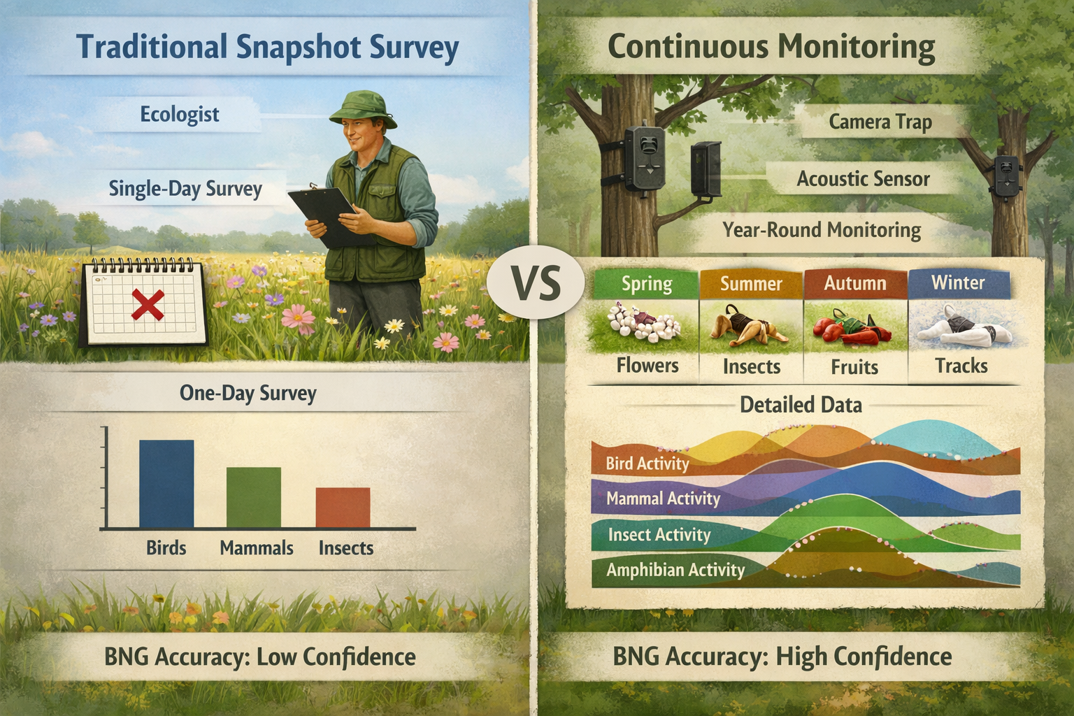
The Temporal Blindness of Single-Season Assessments
Traditional biodiversity surveys typically occur during a single "optimal" season—usually late spring or early summer when vegetation is lush and many species are active. This approach creates significant temporal blindness that undermines BNG accuracy.
Critical limitations include:
- Missed migratory species: Birds, bats, and insects that use sites seasonally remain undetected
- Breeding season bias: Surveys capture peak activity but miss important overwintering or dispersal behaviors
- Phenological gaps: Early spring ephemeral species and autumn fruiting resources go undocumented
- Weather dependency: Poor conditions on survey days can drastically reduce detection rates
Research demonstrates that single-season surveys capture only 40-70% of actual species richness on a given site. For BNG calculations that require precise habitat condition assessments, this data gap translates directly into financial and ecological risk.
Regulatory Pressure for Richer Datasets
The 2026 BNG landscape reflects growing regulatory sophistication. Planning authorities and environmental agencies increasingly scrutinize baseline assessments, demanding evidence that surveys adequately capture temporal variation.
Key regulatory drivers include:
- Statutory BNG requirements mandating 10% net gain with robust evidence
- Increased scrutiny of biodiversity net gain assessments by local planning authorities
- Legal challenges to development approvals based on inadequate baseline data
- Insurance requirements for professional indemnity coverage on BNG projects
Ecology surveyors who continue relying on snapshot methodologies face mounting professional liability and project delays. Understanding what you need for a biodiversity net gain report now includes demonstrating temporal comprehensiveness.
The Financial Cost of Incomplete Data
Underestimating baseline biodiversity value creates cascading financial consequences for developers and landowners:
| Impact Area | Snapshot Survey Risk | Full-Season Monitoring Benefit |
|---|---|---|
| BNG Unit Calculation | Undervalued baseline = higher unit deficit | Accurate baseline = optimized unit requirements |
| Mitigation Design | Inadequate habitat creation targets | Precisely calibrated enhancement measures |
| Statutory Credits | Unexpected credit purchases (£42,000-£650,000/unit) | Minimized credit dependency |
| Project Delays | Re-surveys and assessment challenges | First-time approval confidence |
| Legal Risk | Compliance failures and enforcement | Defensible evidence base |
For developers seeking to achieve 10% biodiversity net gain, the difference between snapshot and continuous monitoring can represent hundreds of thousands of pounds in avoided costs.
Implementing Full-Season Biodiversity Monitoring Protocols for 2026 BNG Accuracy
Designing Year-Round Survey Schedules
Effective full-season monitoring requires strategic scheduling that captures distinct ecological periods rather than arbitrary calendar divisions.
Recommended seasonal survey framework:
🌱 Spring Phase (March-May)
- Early flowering plants and pollinators
- Breeding bird territories establishment
- Amphibian breeding activity
- Bat emergence and spring migration
- Invertebrate emergence patterns
☀️ Summer Phase (June-August)
- Peak vegetation condition assessment
- Breeding bird confirmations
- Butterfly and day-flying moth surveys
- Reptile activity surveys
- Aquatic invertebrate sampling
🍂 Autumn Phase (September-November)
- Fruiting and seed production
- Autumn migrant bird passage
- Bat autumn swarming behavior
- Fungal diversity assessment
- Overwintering habitat evaluation
❄️ Winter Phase (December-February)
- Overwintering bird populations
- Bare ground habitat structure
- Hibernation site identification
- Winter bat roost surveys
- Structural vegetation assessment
This phased approach ensures comprehensive coverage of seasonal dynamics essential for accurate BNG metric calculations. Each phase contributes unique data that single-season surveys systematically miss.
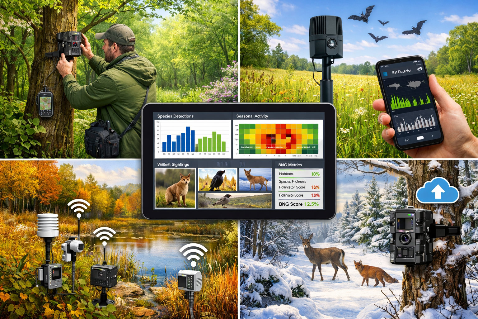
Technology Integration for Continuous Data Collection
Modern monitoring technology enables continuous data collection without proportional increases in surveyor field time—a critical efficiency factor for commercial viability.
Essential technology toolkit:
📷 Camera Traps
- 24/7 mammal and ground bird detection
- Seasonal activity pattern documentation
- Minimal disturbance to sensitive species
- Cost: £150-400 per unit; deployment across 5-10 stations
🎤 Acoustic Sensors
- Automated bat call recording and analysis
- Bird song detection and identification
- Continuous temporal coverage
- Cost: £300-1,200 per unit; 3-5 strategic locations
📱 Mobile Data Collection Apps
- Standardized field recording protocols
- GPS-tagged observations with photos
- Real-time data synchronization
- Cost: £0-150 per license
🛰️ Remote Sensing Integration
- Seasonal vegetation condition monitoring
- Habitat extent change detection
- Phenological pattern tracking
- Cost: Variable based on imagery resolution
💻 Data Management Platforms
- Centralized species records database
- Automated BNG metric calculations
- Temporal analysis and visualization
- Cost: £500-2,000 annual subscription
This technology suite transforms full-season monitoring from labor-intensive to data-rich and cost-effective. The initial investment typically pays for itself through improved BNG accuracy and reduced re-survey requirements.
Standardized Data Collection Protocols
Consistency across seasonal surveys ensures data comparability and metric calculation validity. Standardized protocols prevent the common pitfall of incompatible datasets collected by different surveyors or methodologies.
Core protocol requirements:
- Survey effort standardization: Equal effort across seasons (e.g., 4 hours per habitat type per season)
- Weather condition thresholds: Minimum temperature, maximum wind speed, precipitation limits
- Time of day consistency: Morning, afternoon, and evening surveys appropriately distributed
- Spatial coverage: Consistent transect routes and survey points across seasons
- Observer calibration: Regular inter-observer reliability testing
- Quality assurance: Independent verification of 10-15% of records
These protocols align with guidance provided in comprehensive biodiversity net gain planning resources and ensure professional defensibility.
Integrating Seasonal Data into BNG Metric Calculations
The UK Biodiversity Metric 4.0 framework accommodates temporal data richness when properly integrated into habitat condition assessments.
Key integration points:
Habitat Distinctiveness
- Seasonal species assemblages inform habitat type classification
- Temporal use patterns may elevate distinctiveness categories
- Rare seasonal specialists justify higher distinctiveness scores
Habitat Condition Assessment
- Seasonal vegetation structure variation
- Temporal resource availability (flowers, fruits, seeds)
- Year-round connectivity and functionality
- Seasonal disturbance patterns
Strategic Significance
- Migratory corridor identification through temporal patterns
- Seasonal breeding habitat designation
- Overwintering resource significance
Temporal Multipliers (emerging in advanced assessments)
- Year-round functionality bonus: +10-15%
- Seasonal specialist support: +5-10%
- Migratory pathway value: +10-20%
While not yet formally incorporated into standard metric calculations, documenting these temporal values provides compelling evidence for planning authorities and supports biodiversity net gain strategies that maximize ecological outcomes.
Overcoming Implementation Challenges and Maximizing ROI
Addressing Cost and Resource Concerns
The primary objection to full-season monitoring centers on perceived cost increases. However, strategic implementation reveals that comprehensive monitoring delivers superior return on investment.
Cost optimization strategies:
📉 Reduce Field Visit Intensity
- Deploy autonomous monitoring technology
- Focus intensive surveys on critical seasonal windows
- Use remote sensing to supplement field data
- Implement volunteer and citizen science programs
🔄 Leverage Multi-Site Efficiencies
- Schedule regional survey circuits
- Share equipment across concurrent projects
- Develop seasonal survey teams
- Create standardized reporting templates
💰 Quantify Risk Reduction Value
- Calculate avoided statutory credit costs
- Document reduced re-survey expenses
- Measure planning approval acceleration
- Assess professional liability reduction
Comparative cost analysis:
| Approach | Typical Cost | BNG Accuracy | Risk Level | Time to Approval |
|---|---|---|---|---|
| Single-season snapshot | £3,000-6,000 | 60-70% | High | 8-16 months |
| Two-season survey | £5,000-9,000 | 75-85% | Moderate | 6-12 months |
| Full-season monitoring | £8,000-15,000 | 90-98% | Low | 4-8 months |
For most development projects, the 15-30% cost premium for full-season monitoring represents less than 0.1% of total project value while dramatically reducing compliance risk and approval timelines.
Building Client Understanding and Buy-In
Ecology surveyors must effectively communicate the value proposition of comprehensive monitoring to developers, planners, and landowners who may be accustomed to traditional approaches.
Effective communication strategies:
🎯 Frame as Risk Management
- Emphasize regulatory compliance certainty
- Highlight avoided costs from incomplete assessments
- Reference case studies of snapshot survey failures
- Position as professional standard of care
📊 Demonstrate Data Quality Differences
- Show comparative species lists (snapshot vs. full-season)
- Visualize seasonal activity patterns
- Present before/after BNG calculation differences
- Provide confidence interval comparisons
💼 Align with Business Objectives
- Connect to faster planning approvals
- Link to reduced project uncertainty
- Demonstrate competitive advantage for small development projects
- Support ESG and sustainability commitments
📋 Offer Flexible Implementation
- Phased monitoring with early preliminary assessments
- Scalable approaches based on site complexity
- Technology-first options for budget-conscious clients
- Hybrid models combining intensive and autonomous methods
Understanding common questions planners ask about BNG helps surveyors anticipate client concerns and proactively address them.
Quality Assurance and Professional Standards
As full-season monitoring becomes standard practice, maintaining rigorous quality assurance protects professional reputation and ensures defensible assessments.
Essential QA components:
- Competency verification: Seasonal specialist skills for different taxa
- Equipment calibration: Regular testing and maintenance of monitoring devices
- Data validation: Automated and manual quality checks
- Peer review: Independent expert verification of findings
- Documentation standards: Comprehensive metadata and methodology records
- Audit trails: Complete chain of evidence from field to report
- Continuous improvement: Regular protocol updates based on emerging best practices
Professional bodies increasingly recognize full-season monitoring as the expected standard for BNG assessments. Surveyors who establish robust QA systems position themselves as industry leaders and minimize professional liability exposure.
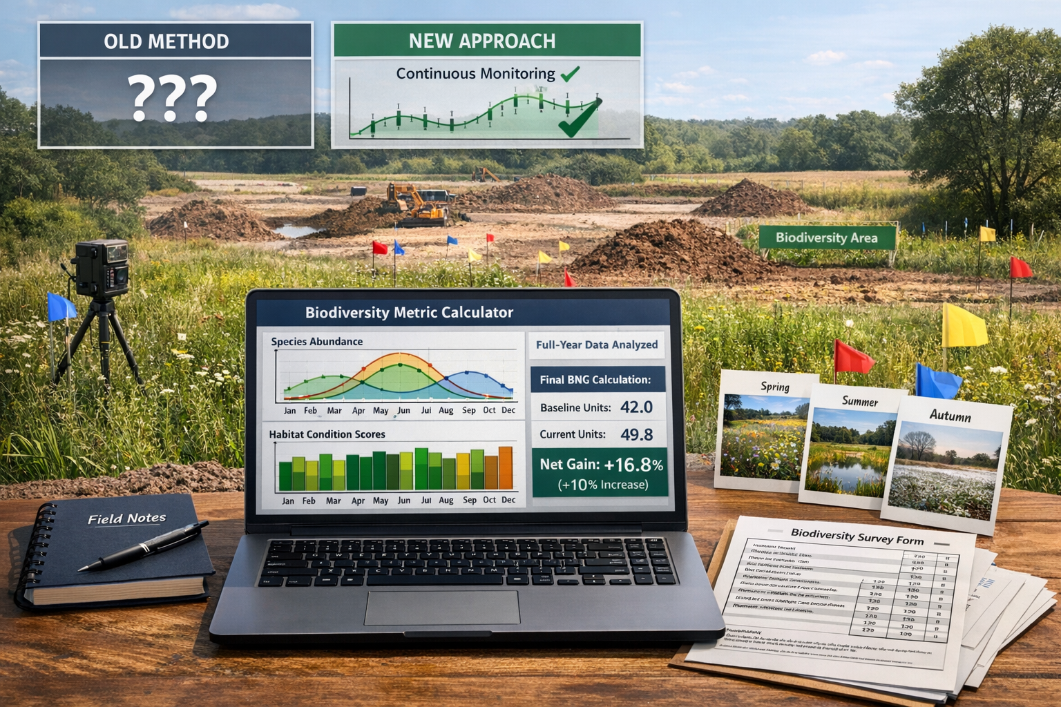
Case Study: Full-Season Monitoring Success
Project: 12-hectare mixed-use development, southern England
Challenge: Initial snapshot survey (June only) suggested moderate biodiversity value requiring 8.2 biodiversity units
Full-Season Approach:
- Four seasonal survey phases (March, June, September, December)
- Camera trap deployment (6 stations, 8 months)
- Acoustic bat monitoring (3 locations, continuous)
- Seasonal vegetation and invertebrate assessments
Results:
- Species richness increased 47% (68 vs. 46 species documented)
- Habitat condition scores improved due to year-round functionality evidence
- BNG unit requirement reduced to 6.1 units (25% reduction)
- Avoided statutory credit costs: £84,000
- Planning approval: First submission acceptance
- Total monitoring cost: £12,500 vs. £5,200 for snapshot
- Net financial benefit: £76,700
This case demonstrates how comprehensive temporal data transforms BNG outcomes and delivers measurable return on investment for clients.
Future-Proofing BNG Assessments: Emerging Trends and Technologies
Artificial Intelligence and Automated Species Identification
The 2026 biodiversity monitoring landscape increasingly incorporates AI-powered species identification, dramatically reducing data processing time while improving accuracy.
Key AI applications:
- Automated image recognition: Camera trap photos analyzed for species identification
- Acoustic analysis: Bat and bird call automatic classification
- Vegetation classification: Remote sensing imagery processed for habitat mapping
- Pattern detection: Seasonal trend identification and anomaly flagging
These technologies enable surveyors to process vastly larger datasets without proportional labor increases, making continuous monitoring economically viable even for smaller projects.
Integration with National Biodiversity Databases
Full-season monitoring data contributes to broader ecological understanding when integrated with national recording schemes and databases.
Benefits of data sharing:
- Enhanced local ecological knowledge
- Contribution to conservation priority setting
- Access to comparative regional datasets
- Strengthened professional credibility
- Support for guidance provided to developers
Surveyors who establish data-sharing partnerships position themselves as conservation leaders while accessing valuable comparative information that strengthens their assessments.
Climate Change Adaptation and Resilience Assessment
Full-season monitoring naturally captures climate-related phenological shifts and seasonal pattern changes that single-season surveys miss entirely.
Climate adaptation insights:
- Earlier spring emergence patterns
- Extended autumn activity periods
- Shifted migration timing
- Changed overwintering behavior
- Novel seasonal species assemblages
These temporal insights inform climate-resilient habitat creation and management strategies that deliver long-term BNG outcomes. Projects that incorporate climate adaptation considerations demonstrate forward-thinking design aligned with emerging planning policy priorities.
Predictive Modeling and Scenario Planning
Rich temporal datasets enable sophisticated predictive modeling that forecasts future biodiversity outcomes under different management scenarios.
Modeling applications:
- Habitat creation success prediction: Based on seasonal establishment patterns
- Species colonization forecasting: Using temporal dispersal data
- Management intervention optimization: Timing aligned with seasonal ecology
- Long-term trajectory modeling: 30-year BNG outcome projections
These advanced analytical approaches transform BNG from static compliance exercise to dynamic ecological planning, delivering genuine conservation outcomes alongside regulatory compliance.
Conclusion: Embracing Continuous Dynamics for BNG Excellence
Full-Season Biodiversity Monitoring: Shifting from Snapshots to Continuous Dynamics for 2026 Net Gain Accuracy represents more than a methodological refinement—it constitutes a fundamental transformation in how ecology professionals approach biodiversity assessment. The evidence is clear: snapshot surveys systematically underestimate ecological value, creating financial risk, regulatory exposure, and missed conservation opportunities.
Ecology surveyors who implement year-round monitoring protocols position themselves at the forefront of professional practice, delivering assessments with unprecedented accuracy and defensibility. The integration of modern monitoring technology makes continuous data collection economically viable while dramatically improving data richness.
Actionable Next Steps for Ecology Surveyors
Immediate actions (next 30 days):
- ✅ Audit current survey protocols to identify temporal gaps in existing methodologies
- ✅ Invest in core monitoring technology (minimum: 3 camera traps, 1 acoustic sensor)
- ✅ Develop standardized seasonal survey templates for consistent data collection
- ✅ Review recent projects to identify where seasonal data would have changed outcomes
Short-term implementation (3-6 months):
- 📋 Pilot full-season monitoring on 2-3 projects to refine protocols
- 📊 Build comparative datasets demonstrating value to clients
- 🤝 Establish technology partnerships with equipment suppliers and data platforms
- 📚 Develop client education materials explaining full-season benefits
Long-term strategic development (6-12 months):
- 🎓 Invest in seasonal specialist training for team members
- 💼 Reposition service offerings with full-season monitoring as standard
- 🔬 Contribute to industry best practice development and knowledge sharing
- 📈 Measure and communicate ROI through case studies and client outcomes
The transition from snapshot to continuous monitoring requires initial investment and methodological adaptation, but the professional and financial returns are substantial. As regulatory expectations evolve and planning authorities demand increasingly robust evidence, full-season monitoring will transition from competitive advantage to professional necessity.
Ecology surveyors who embrace this shift now will lead the industry, delivering BNG assessments that genuinely capture ecological value while protecting clients from compliance risk and financial exposure. The future of biodiversity assessment is continuous, comprehensive, and technology-enabled—and that future is already here in 2026.
For surveyors ready to implement these protocols, the combination of seasonal survey design, autonomous monitoring technology, and rigorous data integration creates a powerful framework for BNG excellence. The question is no longer whether full-season monitoring is necessary, but how quickly professionals can adapt their practices to meet this emerging standard.
By shifting from temporal snapshots to continuous ecological dynamics, the surveying profession can deliver BNG assessments that truly reflect the seasonal pulse of biodiversity—ensuring that development contributes to genuine ecological enhancement rather than merely checking regulatory boxes.
