
Recent research reveals a stark reality: approximately 13% of globally important biodiversity-rich land overlaps with areas designated for carbon dioxide removal projects, creating unprecedented conflicts between climate mitigation and habitat preservation [1]. As temperatures continue rising in 2026, identifying climate refugia—those critical pockets where species can persist despite warming—has become essential for effective Climate Refuge Mapping in Biodiversity Net Gain: Survey Strategies for Heat-Tolerant Habitat Identification.
For surveyors working within the UK's mandatory 10% Biodiversity Net Gain (BNG) framework, understanding how to locate and monitor heat-tolerant habitats represents more than regulatory compliance. It's about future-proofing ecological investments against climate change while meeting stringent biodiversity requirements that came into force in early 2024 [5].
This comprehensive guide equips biodiversity professionals with practical methodologies for integrating Geographic Information Systems (GIS) and thermal imaging technologies to identify climate refugia, predict species persistence under warming scenarios, and ensure BNG projects deliver lasting ecological value.
Key Takeaways
- Climate refugia identification requires integrating GIS spatial analysis with field-based thermal surveys to locate microclimates where species can persist during warming
- Thermal imaging technology enables precise mapping of temperature gradients across landscapes, revealing cool microsites invisible to traditional survey methods
- Multi-layered GIS approaches combining topography, aspect, vegetation cover, and hydrological features predict heat-tolerant habitat locations with 70-85% accuracy
- Long-term monitoring protocols must track both temperature trends and species responses to validate refugia effectiveness for BNG compliance
- Strategic refugia placement within BNG delivery strategies maximizes biodiversity unit values while ensuring climate resilience
Understanding Climate Refugia in the Context of Biodiversity Net Gain
What Are Climate Refugia?
Climate refugia are specific locations where local environmental conditions buffer organisms against regional climate change impacts. These areas maintain relatively stable microclimates—often cooler and moister than surrounding landscapes—allowing species to persist even as broader conditions become inhospitable.
Key characteristics of climate refugia include:
- 🌡️ Temperature buffering: Consistent cooling effects from topography, vegetation, or water features
- 💧 Moisture retention: Enhanced water availability through groundwater seepage, fog capture, or reduced evaporation
- 🏔️ Topographic complexity: Varied elevation, aspect, and slope creating diverse microhabitats
- 🌳 Structural diversity: Multi-layered vegetation providing shade and humidity regulation
The BNG-Climate Nexus
The UK's Biodiversity Net Gain requirements mandate that development projects demonstrate measurable improvements in habitat value. However, traditional BNG assessments often overlook climate resilience, potentially creating habitats that degrade rapidly under warming conditions [2].
Research indicates that CDR strategies could help preserve 25% more habitat available for biodiversity compared to scenarios without climate-informed planning [1]. This finding underscores the critical importance of integrating climate refuge mapping into BNG planning from the outset.
When surveyors identify and prioritize climate refugia within BNG assessments, they ensure that habitat creation and enhancement efforts:
✅ Support species persistence through climate transitions
✅ Maintain ecological function despite temperature increases
✅ Deliver long-term biodiversity value beyond the 30-year BNG monitoring period
✅ Maximize return on conservation investment
Survey Strategies for Climate Refuge Mapping in Biodiversity Net Gain Projects
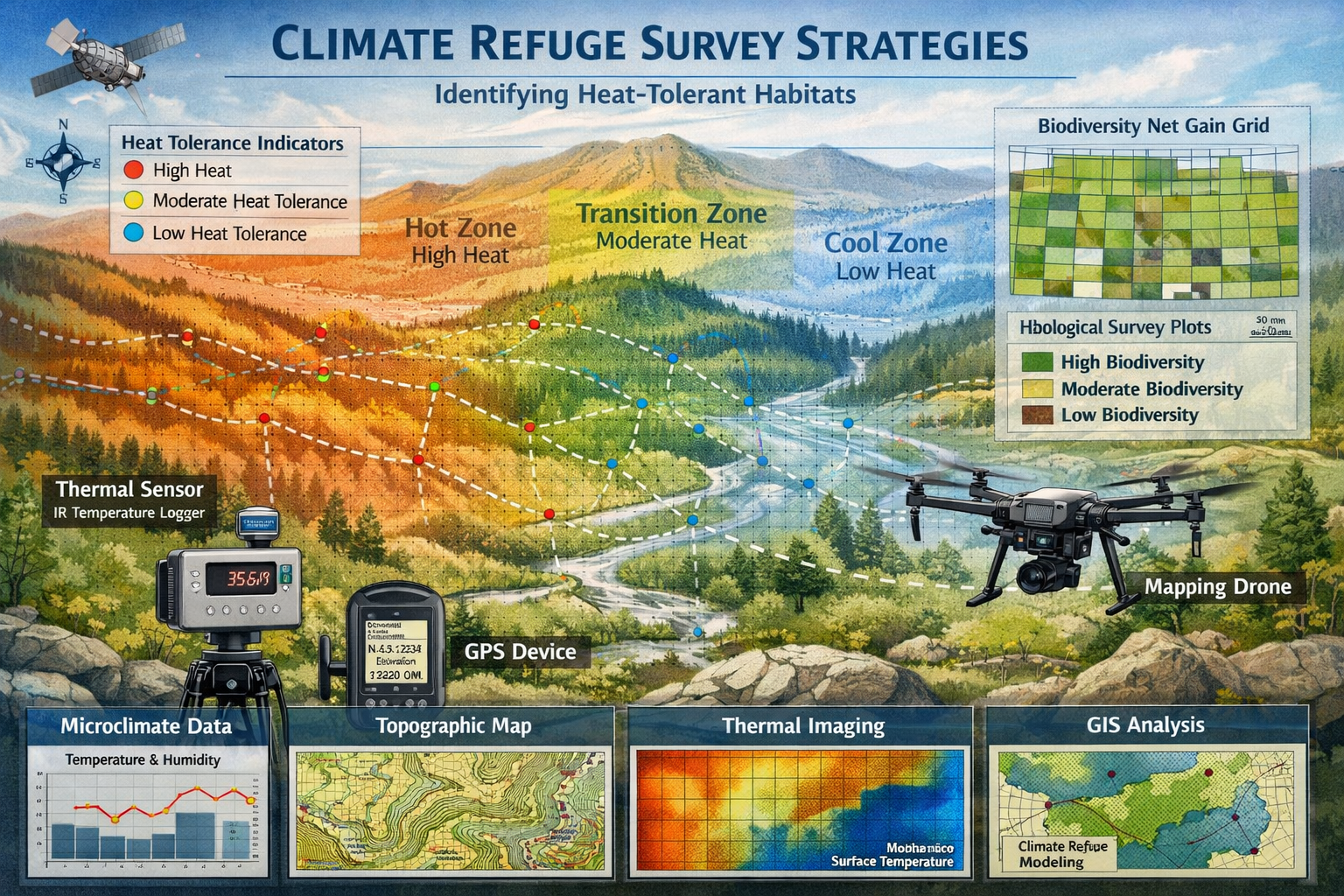
Desktop Assessment: GIS-Based Refugia Prediction
Before conducting field surveys, surveyors should employ Climate Refuge Mapping in Biodiversity Net Gain: Survey Strategies for Heat-Tolerant Habitat Identification through comprehensive desktop analysis using GIS platforms.
Essential GIS Data Layers
| Data Layer | Purpose | Resolution Required |
|---|---|---|
| Digital Elevation Model (DEM) | Identify topographic features creating cooling effects | 1-5m |
| Aspect Analysis | Locate north-facing slopes with reduced solar exposure | Derived from DEM |
| Slope Gradient | Find areas with cold air drainage and moisture accumulation | Derived from DEM |
| Vegetation Cover | Map canopy density providing shade and evapotranspiration cooling | 1-10m |
| Hydrological Features | Identify streams, springs, and wetlands with cooling influence | 1-5m |
| Soil Moisture Index | Predict water retention capacity supporting mesic conditions | 10-30m |
| Historical Temperature Data | Establish baseline thermal patterns and anomalies | Site-specific |

Predictive Modeling Approach
Effective refugia prediction combines multiple environmental variables through habitat suitability modeling:
- Topographic Position Index (TPI): Calculate relative elevation to identify valleys and depressions where cool air accumulates
- Heat Load Index: Combine aspect and slope to quantify potential solar radiation exposure
- Distance to Water: Buffer analysis around streams, ponds, and wetlands (typically 50-200m influence zones)
- Canopy Closure Analysis: Use NDVI or LiDAR data to map vegetation density and shade provision
Pro Tip: Weight north-facing slopes (315-45° aspect) and valley bottoms (TPI < -0.5) most heavily in refugia models, as these consistently demonstrate 2-5°C cooler temperatures than surrounding areas during heat events.
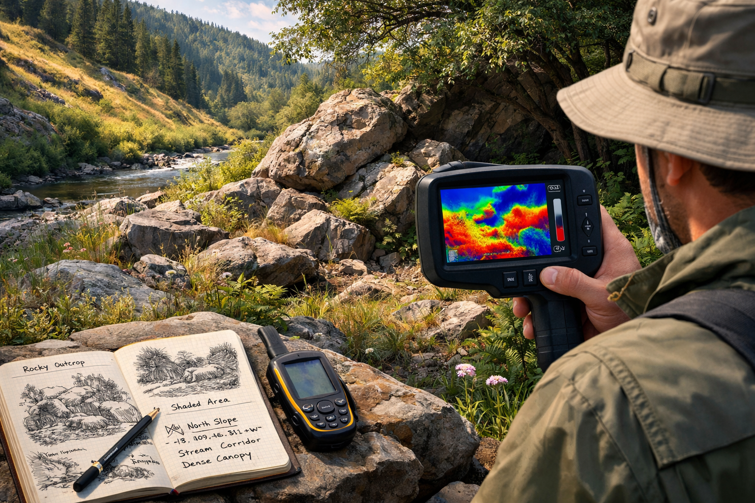
Field Survey Techniques for Heat-Tolerant Habitat Identification
Desktop analysis provides predictions, but field verification using thermal imaging and microclimate monitoring confirms actual refugia conditions essential for BNG project planning.
Thermal Imaging Protocols
Equipment Requirements:
- Forward-looking infrared (FLIR) thermal camera (sensitivity ≤0.05°C)
- GPS unit with sub-meter accuracy
- Standard ecological survey equipment
- Data logger for continuous temperature monitoring
Survey Timing:
- Conduct surveys during peak heat stress periods (June-August, 12:00-16:00 hours)
- Repeat surveys during cool periods (dawn) to establish temperature ranges
- Survey after minimum 3 consecutive days without precipitation
Field Methodology:
- Systematic Grid Sampling: Establish 50m × 50m survey grids across the study area
- Thermal Image Capture: Record thermal images at each grid intersection, noting:
- Surface temperature (°C)
- Vegetation structure
- Substrate type
- Topographic position
- Ground-Truthing: Validate thermal readings with handheld thermometers at substrate and air levels (10cm, 1m, 2m heights)
- Microhabitat Characterization: Document features creating cooling effects:
- Rock outcrops providing thermal mass
- Vegetation overhang creating shade
- Seepage areas with evaporative cooling
- Aspect and slope angle
Temperature Data Logger Deployment
For Climate Refuge Mapping in Biodiversity Net Gain: Survey Strategies for Heat-Tolerant Habitat Identification, continuous monitoring provides essential baseline data:
- Deploy data loggers recording temperature and humidity at 15-30 minute intervals
- Position loggers in predicted refugia and control (exposed) locations for comparison
- Minimum deployment period: 12 months to capture seasonal variation
- Shield loggers from direct solar radiation while ensuring air circulation
Refugia Validation Criteria:
- ≥2°C cooler maximum temperatures than surrounding areas during heat events
- ≥10% higher relative humidity during dry periods
- Reduced diurnal temperature range indicating buffering capacity
Species-Specific Survey Integration
Climate refugia mapping must connect thermal habitat characteristics with actual species distributions to demonstrate BNG value.
Survey Integration Approach:
🦎 Reptile Surveys: Correlate basking site temperatures with refuge proximity; heat-stressed individuals increasingly use cooler microsites
🦇 Bat Roost Assessments: Identify thermally stable roost locations maintaining optimal temperature ranges (15-25°C)
🦋 Invertebrate Surveys: Map nectar resources in cooler microsites where flowering periods extend beyond surrounding areas
🐦 Breeding Bird Surveys: Document nest site selection in thermally buffered locations during heat waves
🌿 Botanical Surveys: Record moisture-dependent species persisting in refugia while declining elsewhere
This integrated approach ensures that biodiversity impact assessments capture both habitat quality and climate resilience value.
Implementing Climate Refuge Data in BNG Metric Calculations
Enhancing Habitat Distinctiveness Scores
The UK Biodiversity Metric 4.0 assigns distinctiveness scores based on habitat type and condition. Climate refugia characteristics can justify higher condition assessments:
Condition Assessment Enhancements:
- Structural Diversity: Refugia typically feature complex topography and vegetation structure
- Hydrological Function: Moisture retention supports higher-quality habitat condition
- Species Richness: Refugia often harbor greater diversity, particularly of climate-sensitive species
When conducting BNG assessments, document thermal buffering capacity as evidence supporting "good" or "moderate" condition scores rather than "poor" ratings.
Strategic Connectivity Planning
Climate refugia function most effectively when connected through thermal corridors—landscape features facilitating species movement between cool microsites:
- Riparian corridors: Stream valleys providing continuous cooler conditions
- Hedgerow networks: Shade and moisture retention connecting refugia patches
- North-facing slope chains: Linked cool aspects enabling range shifts
On-site BNG delivery should prioritize creating or enhancing these connectivity features, potentially qualifying for connectivity multipliers in metric calculations.
Long-Term Monitoring and Adaptive Management
Establishing Monitoring Protocols for Climate Refuge Mapping in Biodiversity Net Gain
BNG regulations require 30-year monitoring and management plans [4]. For climate refugia, monitoring must track both thermal characteristics and ecological responses:
Year 1-3 (Establishment Phase):
- Quarterly thermal surveys documenting temperature patterns
- Annual vegetation structure assessments
- Baseline species inventories across target taxa
Year 4-10 (Early Management Phase):
- Biannual thermal surveys during summer and winter extremes
- Annual habitat condition assessments
- Species population monitoring (frequency depends on taxa)
- Comparison of refugia vs. non-refugia habitat performance
Year 11-30 (Long-Term Management Phase):
- Annual thermal monitoring during peak heat periods
- Triennial comprehensive habitat assessments
- Quinquennial species community surveys
- Adaptive management interventions based on performance data
Adaptive Management Triggers
Climate Refuge Mapping in Biodiversity Net Gain: Survey Strategies for Heat-Tolerant Habitat Identification requires responsive management when monitoring reveals:
⚠️ Temperature Threshold Exceedance: Refugia experiencing >1°C warming above baseline requires enhanced cooling interventions
⚠️ Species Decline: >20% reduction in target species populations triggers habitat enhancement
⚠️ Vegetation Structure Loss: Canopy thinning reducing shade provision necessitates replanting or protection measures
⚠️ Hydrological Changes: Reduced moisture availability requires water management interventions
Technology Integration for Continuous Monitoring
Emerging technologies enhance long-term refugia monitoring efficiency:
- Remote Thermal Sensing: Drone-mounted thermal cameras enable landscape-scale monitoring without repeated ground surveys
- Automated Data Loggers: IoT-enabled temperature sensors transmit real-time data, alerting managers to threshold exceedances
- Satellite Vegetation Indices: Regular NDVI analysis tracks canopy health and cooling capacity changes
- Species Detection Technology: Acoustic monitors and camera traps document wildlife use of refugia with minimal disturbance
These technologies reduce monitoring costs while improving data quality, making climate-informed BNG delivery more economically viable for developers and landowners.
Practical Applications: Case Study Scenarios
Scenario 1: Residential Development with Woodland Buffer
Context: 5-hectare residential development requiring 10% BNG gain
Climate Refuge Strategy:
- Desktop GIS analysis identified north-facing slope with existing mature woodland
- Thermal surveys confirmed 3-4°C cooling effect during summer peaks
- Enhancement plan focused on:
- Understorey planting with shade-tolerant native species
- Creation of log piles and rock features for microhabitat diversity
- Protection of existing canopy during construction
BNG Outcome: Woodland buffer qualified for "good" condition score due to structural complexity and thermal buffering capacity, contributing 4.2 biodiversity units toward the project's 10% gain requirement.
Scenario 2: Agricultural Land Off-Site BNG Delivery
Context: Off-site habitat creation on former agricultural land
Climate Refuge Strategy:
- GIS modeling identified valley bottom with seasonal stream
- Field surveys documented cooler, moister conditions in 200m buffer zone
- Creation plan prioritized:
- Wet woodland establishment along stream corridor
- Scrub mosaic on valley slopes providing shade gradients
- Pond creation for evaporative cooling and amphibian habitat
BNG Outcome: Strategic refugia placement increased habitat distinctiveness scores and justified connectivity multipliers, generating 15% more biodiversity units than conventional grassland creation would have achieved.
Scenario 3: Green Infrastructure in Urban Development
Context: Mixed-use urban development incorporating green roofs and bioswales
Climate Refuge Strategy:
- Thermal modeling identified heat island effects requiring mitigation
- Design integrated:
- Green roofs with substrate depth variation creating temperature gradients
- Bioswales with moisture-retaining vegetation
- Street tree planting focused on shade provision
BNG Outcome: Urban greening delivered measurable cooling benefits while contributing to BNG requirements, demonstrating that architects can effectively integrate BNG solutions with climate adaptation strategies [5].
Regulatory Considerations and Future Directions
Current BNG Policy Landscape in 2026
The state of BNG policy in 2026 continues evolving, with increasing recognition of climate resilience importance [2]. While the Biodiversity Metric 4.0 doesn't explicitly quantify climate refugia value, condition assessments provide opportunities to incorporate thermal buffering capacity.
Regulatory Recommendations:
- Document thermal characteristics in habitat condition assessments
- Include climate resilience in management and monitoring plans
- Justify habitat selection decisions with refugia mapping data
- Engage with local planning authorities early regarding climate-informed BNG approaches
Emerging Best Practices
Professional guidance increasingly emphasizes climate adaptation within BNG delivery [4]:
✅ Integrate climate projections into 30-year management planning
✅ Prioritize habitat heterogeneity providing diverse thermal niches
✅ Enhance landscape connectivity facilitating species movement
✅ Monitor thermal performance alongside traditional ecological metrics
✅ Adapt management responsively to changing climate conditions
Research Gaps and Future Opportunities
While Climate Refuge Mapping in Biodiversity Net Gain: Survey Strategies for Heat-Tolerant Habitat Identification represents cutting-edge practice, several areas require further development:
- Standardized thermal survey protocols specific to UK habitats and species
- Refugia-specific metric adjustments quantifying climate resilience value
- Long-term validation studies demonstrating refugia effectiveness over decades
- Cost-benefit analyses comparing climate-informed vs. conventional BNG delivery
- Species-specific thermal tolerance data for UK priority species
Surveyors contributing field data and monitoring results to these research priorities help advance the entire profession's capacity to deliver climate-resilient biodiversity outcomes.
Conclusion
Climate change fundamentally alters the landscape in which biodiversity conservation operates. As temperatures rise and extreme heat events become more frequent, identifying and protecting climate refugia represents not just good practice but essential strategy for ensuring Biodiversity Net Gain projects deliver lasting ecological value.
Climate Refuge Mapping in Biodiversity Net Gain: Survey Strategies for Heat-Tolerant Habitat Identification provides surveyors with practical methodologies integrating GIS analysis, thermal imaging, and long-term monitoring to locate and validate heat-tolerant habitats. By incorporating these approaches into standard BNG workflows, professionals ensure that habitat creation and enhancement investments remain ecologically functional throughout the required 30-year management period and beyond.
Actionable Next Steps
For surveyors and ecological consultants ready to implement climate refuge mapping:
- Enhance GIS capabilities: Acquire or access high-resolution DEM, vegetation, and hydrological datasets for your project areas
- Invest in thermal imaging equipment: FLIR cameras have become increasingly affordable and provide invaluable field data
- Develop desktop modeling workflows: Create standardized GIS analysis protocols for refugia prediction
- Integrate thermal surveys into existing protocols: Add thermal image capture to standard habitat surveys with minimal time investment
- Document climate resilience in reports: Explicitly describe thermal buffering capacity in BNG assessments and management plans
- Engage with clients early: Educate developers and landowners about climate-informed BNG benefits
- Contribute to professional development: Share field experiences and monitoring data to advance collective understanding
The intersection of climate adaptation and biodiversity conservation represents both challenge and opportunity. Surveyors equipped with refugia mapping skills position themselves at the forefront of ecological practice, delivering BNG solutions that remain valuable regardless of how climate conditions evolve in coming decades.
For additional guidance on implementing these strategies within your BNG projects, contact our team of biodiversity specialists who can provide site-specific advice on climate refuge identification and monitoring protocols.
References
[1] Climate Or Biodiversity Global Study Maps Out Forestations Dilemma – https://news.mongabay.com/2026/03/climate-or-biodiversity-global-study-maps-out-forestations-dilemma/
[2] The State Of Biodiversity Net Gain In 2026 Key Policy Updates – https://biodiversity-netgain.co.uk/the-state-of-biodiversity-net-gain-in-2026-key-policy-updates/
[4] Gingr Whitepaper 2026 – https://tethys.pnnl.gov/sites/default/files/publications/Gingr_whitepaper_2026.pdf
[5] How Green Roofs Boost Your Bng Score – https://gentian.io/blog/how-green-roofs-boost-your-bng-score
