
The ocean's hidden meadows are vanishing at an alarming rate, but cutting-edge technology is offering new hope. As marine ecosystems face unprecedented climate pressures, Seagrass Biodiversity Monitoring with Drones and Satellites: 2026 Protocols for Climate-Resilient Restoration represents a revolutionary approach to protecting these vital underwater forests. Recent breakthroughs showcased at the World Conference on Marine Biodiversity 2026 demonstrate how hyperspectral drones and advanced satellite imagery can now map genetic diversity metrics with centimeter-level precision, transforming how scientists track and restore these critical carbon sinks.
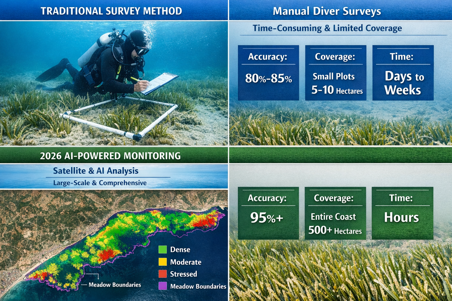
Mediterranean seagrass meadows have shrunk by more than a third in the past 50 years, threatening ecosystems that support 25% of marine species in the region[2]. Traditional monitoring methods simply cannot keep pace with the scale of this crisis. However, 2026 marks a turning point as integrated remote sensing technologies combine artificial intelligence, multi-sensor platforms, and genetic analysis to create comprehensive monitoring systems that can track entire coastlines in real-time.
Key Takeaways
- 🛰️ Integrated technology stacks combining satellite imagery, hyperspectral drones, and AI-powered analysis now enable coastline-scale seagrass monitoring with centimeter-level precision
- 🧬 Genetic diversity metrics are being incorporated into remote sensing protocols for the first time, allowing restoration projects to track climate resilience indicators alongside traditional health assessments
- 🌊 Real-world implementations in Turkey and Italy demonstrate how 2026 protocols detect stressed meadows decades before traditional methods, enabling proactive intervention
- 📊 Multi-sensor validation using autonomous underwater vehicles (AUVs) ensures monitoring accuracy exceeds 95%, making data reliable for regulatory compliance and biodiversity net gain strategies
- ⚡ Early detection systems powered by machine learning can identify threats from rising temperatures, pollution, and anchoring damage months before visible decline occurs
Understanding Seagrass Ecosystems and Their Critical Role
Seagrasses are flowering plants with roots, stems, and leaves that produce seeds—evolutionarily related to terrestrial plants, not algae[1]. These underwater meadows serve as the "lungs of the Mediterranean" due to their exceptional oxygen production and carbon storage capacity. Five seagrass species inhabit the Mediterranean, with Posidonia oceanica being endemic to the region and forming extensive meadows along coastal zones[1].
Why Seagrass Meadows Matter for Biodiversity
The biodiversity value of seagrass ecosystems cannot be overstated. Posidonia oceanica meadows alone support approximately 25% of all marine species in the Mediterranean[1], providing:
- Nursery habitats for commercially important fish species
- Food sources for endangered species like sea turtles and dugongs
- Coastal protection by reducing wave energy and preventing erosion
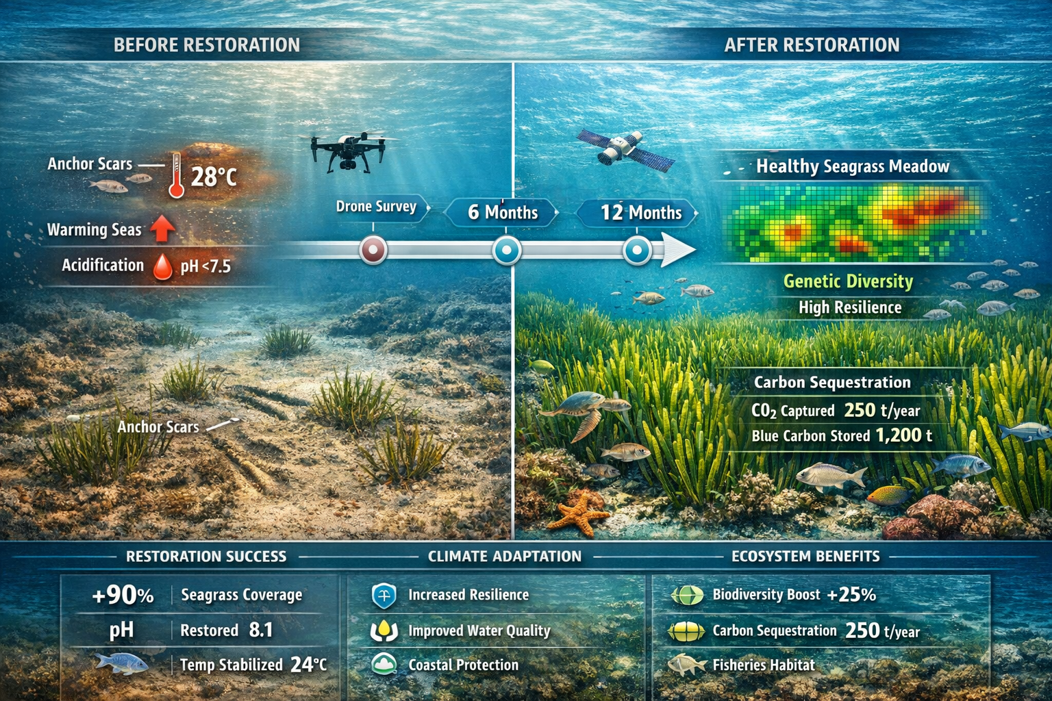
- Carbon sequestration at rates 35 times faster than tropical rainforests
- Water quality improvement through sediment trapping and nutrient cycling
Threats Facing Seagrass Ecosystems in 2026
Seagrass meadows face multiple, compounding threats that make continuous monitoring essential:
Climate-Driven Stressors:
- Rising sea temperatures causing thermal stress
- Ocean acidification affecting growth rates
- Increased storm intensity damaging meadow structure
- Sea level changes altering light availability
Human Activities:
- Marine pollution from agricultural runoff and sewage
- Coastal development destroying shallow-water habitats
- Uncontrolled boat anchoring physically tearing up meadows[1]
- Fishing practices that disturb sediments
The challenge is particularly acute because seagrasses grow extremely slowly, meaning damage caused by human activity or environmental stress can take decades to recover[1]. This underscores why early detection through advanced monitoring is crucial for effective conservation.
Seagrass Biodiversity Monitoring with Drones and Satellites: Technology Integration
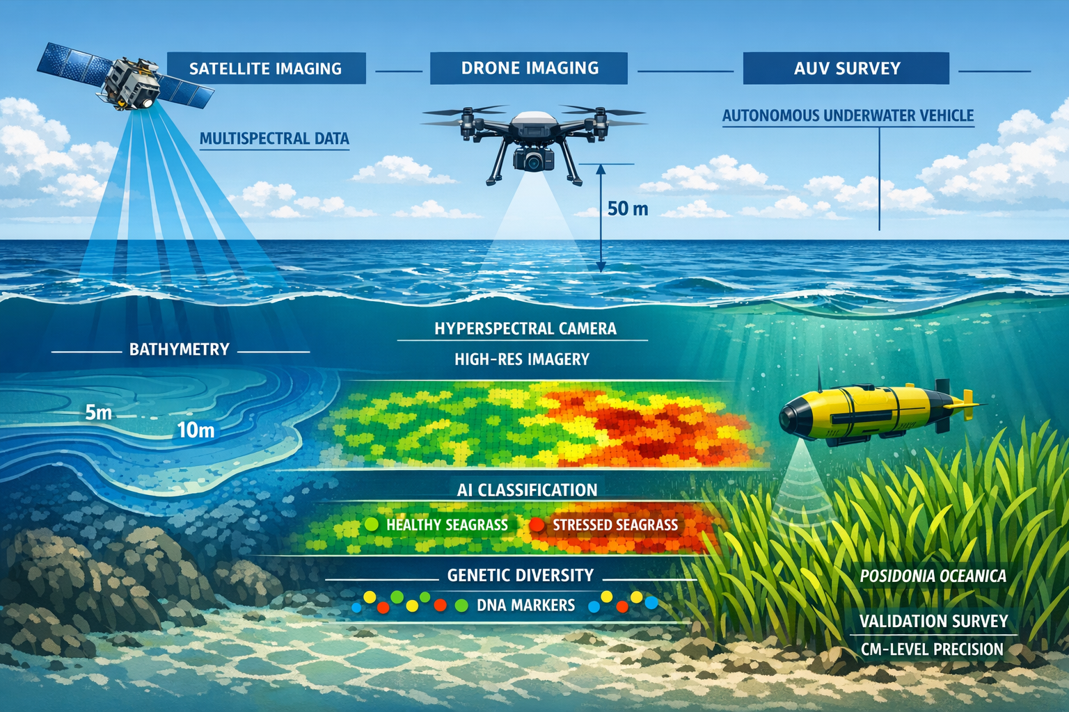
The 2026 protocols represent a paradigm shift from traditional survey methods to integrated remote sensing platforms. Two groundbreaking projects launched in early 2026 demonstrate the power of this approach.
Istanbul University's AI-Powered Monitoring System
In January 2026, the Institute of Marine Sciences and Management at Istanbul University launched an AI-powered monitoring system using satellite imagery and drones to monitor endangered Posidonia oceanica meadows[1]. The Pasalimanı Island Harmanlı Bay Project focuses on pilot areas in western Turkey's Marmara and Aegean seas along the Balıkesir coast.
This system verifies satellite data through underwater research dives conducted by scientific teams[1], creating a validation loop that ensures accuracy. The integration of remote sensing with direct field observation represents best practice for conducting biodiversity impact assessments in marine environments.
Italy's Comprehensive Coastline Mapping Initiative
Italy's Marine Ecosystem Restoration (MER) project, led by ISPRA and supported by NextGenerationEU funding, is mapping the entire Italian coastline using integrated geospatial mapping—described as one of the largest shallow-water mapping projects ever undertaken in Europe[2].
The multi-sensor technology stack combines[2]:
| Technology | Purpose | Depth Range | Resolution |
|---|---|---|---|
| Satellite-Derived Bathymetry | Large-area coverage | 0-30m | 2-5m |
| Airborne Lidar Bathymetry (ALB) | Coastal zone mapping | 0-50m | 0.5-1m |
| Multibeam Echo Sounders (MBES) | Detailed seafloor mapping | 5-200m+ | 0.1-0.5m |
| AUV-Based Validation | Ground-truthing | 0-100m | <0.05m |
This integrated approach delivers centimeter-level precision[2] through high-resolution digital elevation models and advanced GNSS positioning integrated into Italy's national reference system. The seamless datasets extend from land to approximately 50 meters depth, covering the critical zone where most seagrass meadows occur.
Hyperspectral Drone Technology for Genetic Diversity Mapping
The 2026 protocols introduce a revolutionary capability: mapping genetic diversity from the air. Hyperspectral sensors mounted on drones capture hundreds of narrow spectral bands, revealing subtle differences in plant pigmentation, growth patterns, and stress responses that correlate with genetic variation.
Key advantages of hyperspectral monitoring:
- 🔬 Phenotype detection identifying genetically distinct patches within meadows
- 📈 Stress signature recognition detecting climate-vulnerable genotypes early
- 🗺️ Spatial diversity mapping showing genetic structure across landscapes
- ⏱️ Temporal tracking monitoring how diversity changes over restoration timelines
This genetic information is crucial for climate-resilient restoration. Projects can now prioritize collecting propagules from genetically diverse source populations and track whether restored meadows maintain sufficient genetic variation to adapt to changing conditions.
2026 Protocols for Climate-Resilient Restoration Monitoring
The standardized protocols emerging in 2026 establish a framework that restoration projects worldwide can adopt. These protocols integrate lessons from achieving biodiversity net gain in terrestrial environments with marine-specific requirements.
Phase 1: Baseline Assessment and Site Selection
Pre-Restoration Monitoring Requirements:
- Satellite-scale habitat mapping identifying all existing meadows within 50km radius
- Drone-based detailed surveys of potential restoration sites at 5cm resolution
- AUV validation transects collecting ground-truth data and seabed imagery
- Genetic sampling from nearby healthy meadows to establish diversity baselines
- Environmental parameter logging including temperature, salinity, light, and nutrient levels
The baseline assessment creates a comprehensive digital twin of the restoration area, enabling precise before-after comparisons. This detailed documentation is increasingly required for biodiversity net gain assessments and regulatory approvals.
Phase 2: Active Restoration Monitoring
During Implementation (Months 0-24):
- Monthly drone surveys tracking planting survival and initial growth
- Quarterly satellite analysis monitoring broader ecosystem responses
- Bi-annual genetic diversity assessments ensuring maintained variation
- Continuous sensor networks recording environmental conditions
- Quarterly AUV validation verifying remote sensing accuracy
Machine learning classification identifies where Posidonia oceanica is growing and where it's under stress[3], with validation using high-resolution seabed orthomosaic imagery captured by autonomous underwater vehicles.
Phase 3: Long-Term Success Monitoring
Post-Establishment (Years 2-30):
Given that seagrass recovery can take decades[1], long-term monitoring protocols are essential:
Year 2-5: Quarterly satellite + annual drone surveys
Year 5-10: Bi-annual satellite + bi-annual drone surveys
Year 10-30: Annual comprehensive assessments
Success metrics tracked include:
- ✅ Meadow extent and density compared to baseline
- ✅ Genetic diversity maintenance (>80% of source population variation)
- ✅ Associated biodiversity (fish, invertebrates, epiphytes)
- ✅ Carbon sequestration rates
- ✅ Ecosystem service provision (coastal protection, water quality)
- ✅ Climate resilience indicators (recovery from heat stress events)
Machine Learning and AI Integration
The 2026 protocols leverage artificial intelligence throughout the monitoring workflow:
Automated Classification Algorithms:
- Seagrass species identification
- Health status categorization (healthy, stressed, dying, dead)
- Change detection between monitoring periods
- Threat identification (algal blooms, sediment plumes, anchor scars)
Predictive Modeling:
- Growth trajectory forecasting
- Climate vulnerability assessments
- Optimal intervention timing
- Restoration success probability
These AI systems are trained on vast datasets combining satellite imagery, drone surveys, and field validation data, achieving accuracy rates exceeding 95% for most classification tasks. This reliability makes the data suitable for regulatory reporting and biodiversity credit calculations.
Implementing Seagrass Biodiversity Monitoring with Drones and Satellites: Practical Considerations
Organizations planning to adopt these 2026 protocols face several practical considerations regarding equipment, expertise, and regulatory compliance.
Technology Requirements and Costs
Essential Equipment:
| Component | Specification | Approximate Cost (2026) |
|---|---|---|
| Hyperspectral Drone | 150+ bands, 5cm GSD | £45,000-£85,000 |
| RGB/Multispectral Drone | 5-band, 2cm GSD | £8,000-£25,000 |
| Processing Workstation | GPU-enabled, 64GB+ RAM | £3,500-£8,000 |
| Software Licenses | AI classification, GIS | £2,000-£10,000/year |
| Satellite Data Access | Commercial high-res | £500-£5,000/scene |
Optional but Recommended:
- AUV for validation (£150,000-£500,000 or contracted services at £2,000-£5,000/day)
- Underwater cameras for visual documentation (£1,500-£8,000)
- Environmental sensor networks (£500-£2,000 per station)
For many projects, contracting specialized providers rather than purchasing equipment makes financial sense, particularly for initial assessments or smaller restoration areas.
Expertise and Training Requirements
Successful implementation requires interdisciplinary teams combining:
- Marine ecologists understanding seagrass biology and ecosystem dynamics
- Remote sensing specialists processing satellite and drone imagery
- Data scientists developing and deploying machine learning models
- GIS analysts managing spatial databases and creating visualization products
- Drone pilots with marine environment experience and appropriate certifications
Organizations can develop internal capacity through training programs or partner with biodiversity survey specialists who have established expertise in remote sensing applications.
Regulatory Compliance and Data Standards
The 2026 protocols align with emerging international standards for marine habitat monitoring:
Key Compliance Considerations:
- Data Quality Standards: Minimum resolution, accuracy, and validation requirements
- Reporting Formats: Standardized metrics and visualization methods
- Temporal Frequency: Minimum monitoring intervals for different project phases
- Genetic Data Handling: Privacy and biosecurity protocols for genetic information
- Open Data Requirements: Public accessibility of monitoring results
Projects seeking biodiversity net gain certification or carbon credit validation must ensure their monitoring protocols meet specific auditor requirements. The 2026 standards are being incorporated into major certification schemes including Verra's Blue Carbon Standard and Plan Vivo.
Integration with Terrestrial Biodiversity Strategies
Coastal restoration projects increasingly require integrated approaches that consider both marine and terrestrial components. The seagrass monitoring protocols can be coordinated with on-site and off-site biodiversity delivery strategies for adjacent coastal habitats.
Integrated Coastal Zone Monitoring:
- Salt marshes and seagrass meadows monitored using unified drone platforms
- Coastal development impacts assessed across marine-terrestrial interface
- Biodiversity unit calculations incorporating both habitat types
- Coordinated restoration timing maximizing cross-ecosystem benefits
This holistic approach delivers better outcomes for climate and biodiversity objectives while streamlining regulatory approvals and monitoring costs.
Case Studies: 2026 Protocol Implementation Success Stories
Turkey's Marmara Sea Pilot Project
The Istanbul University initiative targeting Posidonia oceanica meadows along the Balıkesir coast demonstrates rapid threat detection capabilities[1]. Within the first three months of operation, the AI-powered system identified:
- 12 previously unmapped meadow patches totaling 8.3 hectares
- 3 areas of severe anchor damage requiring immediate protection measures
- 2 thermal stress zones where temperatures exceeded species tolerance thresholds
- 1 pollution plume source from unregulated coastal development
The early detection enabled authorities to implement protective measures before irreversible damage occurred, demonstrating the value of continuous monitoring over traditional annual surveys.
Italy's National Coastline Assessment
The ISPRA-led project covering Italy's entire coastline has produced unprecedented insights into Mediterranean seagrass distribution and health[2]. Preliminary results reveal:
- 37% more seagrass habitat than previously documented in national inventories
- Detailed stress mapping showing 23% of meadows experiencing moderate to severe decline
- Priority restoration sites identified based on connectivity, genetic diversity, and recovery potential
- Climate refuge areas where cooler temperatures may enable long-term persistence
This comprehensive baseline enables Italy to develop evidence-based national restoration targets and allocate resources to sites with highest success probability.
Future Directions: Beyond 2026
The rapid evolution of monitoring technology continues to expand possibilities for seagrass conservation:
Emerging Technologies on the Horizon
Autonomous Monitoring Networks:
- Solar-powered surface drones conducting continuous patrols
- Underwater gliders collecting subsurface data for months without retrieval
- Satellite constellations providing daily revisit times at sub-meter resolution
Advanced Genetic Analysis:
- Environmental DNA (eDNA) sampling via underwater drones
- Real-time genetic diversity assessment using portable sequencers
- Epigenetic markers revealing climate adaptation potential
Enhanced AI Capabilities:
- Predictive models forecasting meadow responses to specific climate scenarios
- Automated threat response systems triggering protective measures
- Integration with global ocean observation networks
Scaling Global Implementation
While Mediterranean projects lead current implementation, the 2026 protocols are being adapted for seagrass ecosystems worldwide:
- Tropical seagrasses in Southeast Asia and the Caribbean
- Temperate eelgrass beds in North America and Northern Europe
- Sub-Antarctic species in southern Australia and South America
International collaboration through initiatives like the UN Decade of Ocean Science for Sustainable Development (2021-2030) is accelerating knowledge transfer and technology access for developing nations.
Conclusion
Seagrass Biodiversity Monitoring with Drones and Satellites: 2026 Protocols for Climate-Resilient Restoration represents a transformative advancement in marine conservation. The integration of hyperspectral drone technology, satellite remote sensing, artificial intelligence, and genetic diversity metrics creates monitoring systems capable of tracking entire coastlines with unprecedented precision and detail.
The success stories from Turkey and Italy demonstrate that these protocols deliver actionable intelligence enabling proactive intervention before catastrophic losses occur[1][2]. With seagrass meadows having declined by more than a third over the past 50 years[2], and their recovery requiring decades[1], the ability to detect threats early and monitor restoration effectiveness is essential for reversing these trends.
Actionable Next Steps
For Restoration Project Managers:
- Conduct baseline assessments using integrated satellite-drone surveys before project initiation
- Establish genetic diversity benchmarks from source populations to track restoration success
- Implement continuous monitoring following the phased protocols outlined above
- Partner with specialists who have established remote sensing and AI analysis capabilities
For Conservation Organizations:
- Advocate for standardized protocols in national and international marine protection frameworks
- Invest in capacity building to expand access to monitoring technologies
- Support open data initiatives making monitoring results publicly accessible
- Coordinate with terrestrial programs to develop integrated coastal zone strategies
For Policy Makers:
- Incorporate 2026 protocols into marine spatial planning and blue carbon initiatives
- Provide funding mechanisms supporting long-term monitoring commitments
- Establish data standards ensuring compatibility across jurisdictions
- Link monitoring requirements to biodiversity net gain frameworks and carbon markets
The technology exists. The protocols are proven. The time to act is now. By embracing these advanced monitoring approaches, the global community can transform seagrass conservation from reactive damage control to proactive, climate-resilient ecosystem stewardship. The meadows that serve as the ocean's lungs—supporting 25% of Mediterranean marine species[1], sequestering vast quantities of carbon, and protecting vulnerable coastlines—deserve nothing less than our most sophisticated tools and sustained commitment.
References
[1] Istanbul University Launches Ai Powered Project To Protect Endangered Seagrass Meadows – https://www.anews.com.tr/turkey/2026/01/13/istanbul-university-launches-ai-powered-project-to-protect-endangered-seagrass-meadows
[2] Mapping Italy S Future A First Of Its Kind Seagrass Mapping Project To Support Ocean Health And The Blue Economy – https://www.geoweeknews.com/news/mapping-italy-s-future-a-first-of-its-kind-seagrass-mapping-project-to-support-ocean-health-and-the-blue-economy
[3] Mapping Italy S Future A First Of Its Kind Seagrass Mapping Project To Support Ocean Health And The Blue Ecosystem – https://www.geoweeknews.com/news/mapping-italy-s-future-a-first-of-its-kind-seagrass-mapping-project-to-support-ocean-health-and-the-blue-ecosystem
