
Analysis of a Wisconsin-sized region on Alaska's North Slope reveals runoff increasing sharply, rivers carrying unprecedented amounts of ancient carbon, and the thaw season now extending into September and October—weeks longer than previously documented.[1] This accelerating transformation demands immediate action from ecologists, conservation planners, and biodiversity professionals working in warming frontiers. Permafrost Thaw Tracking in Arctic Biodiversity Surveys: Drone and Ground Protocols for 2026 Net Gain Assessments represents a critical framework for monitoring methane-emitting thaw zones and associated species shifts in real-time.
The stakes couldn't be higher. Permafrost globally contains approximately 1,700 billion metric tons of carbon—roughly three times the amount currently in the atmosphere.[2] As these frozen soils thaw, they become 25 to 100 times more permeable, allowing greenhouse gases to escape more readily and fundamentally altering Arctic ecosystems.[2] For professionals conducting biodiversity net gain assessments, understanding these rapid environmental shifts is essential for accurate baseline documentation and future habitat projections.
Key Takeaways
- 🚁 Hybrid drone-ground protocols enable rapid detection of methane-emitting thaw zones and vegetation changes across vast Arctic territories
- 📊 Thermal imaging and LiDAR technology reveal subsurface permafrost degradation patterns invisible to standard visual surveys
- 🌱 Species composition shifts occur within 2-5 years following abrupt thaw events, requiring frequent re-surveying for accurate net gain calculations
- 📈 Carbon flux monitoring must be integrated with traditional biodiversity metrics to capture full ecosystem transformation
- ⚡ Rapid-response frameworks allow ecologists to document habitat changes during critical thaw windows extending into late autumn
Understanding Permafrost Thaw Dynamics and Biodiversity Implications
The Science Behind Accelerating Thaw
Permafrost thaw isn't a gradual, uniform process. Recent research from northwest Alaska shows the largest rise in carbon export, with scientists identifying carbon from decaying organic matter that has been accumulating for tens of thousands of years.[1] This ancient carbon release signals fundamental ecosystem restructuring that biodiversity professionals must account for in their assessments.
Key thaw mechanisms affecting biodiversity surveys include:
- Thermokarst formation: Ground subsidence creating new wetland habitats
- Active layer deepening: Expanding soil depth available for root penetration
- Hydrological shifts: Altered drainage patterns affecting aquatic species
- Vegetation succession: Rapid transitions from tundra to shrubland ecosystems
Laboratory experiments demonstrate that thawing permafrost becomes exponentially more permeable, fundamentally changing how water, nutrients, and gases move through Arctic soils.[2] This permeability surge creates "hotspots" of biological activity that attract different species assemblages than surrounding stable permafrost areas.
Biodiversity Response Patterns
Arctic vegetation takes decades to recover following abrupt permafrost thaw, with distinct successional stages requiring different survey approaches.[4] Understanding these patterns is crucial for professionals developing biodiversity net gain strategies in Arctic and sub-Arctic regions.
Typical biodiversity response timeline:
| Years Post-Thaw | Vegetation Changes | Fauna Response | Survey Priority |
|---|---|---|---|
| 0-2 | Moss/lichen die-off, bare ground exposure | Invertebrate population crashes | Baseline documentation |
| 3-5 | Pioneer grass/sedge colonization | Migratory bird habitat shifts | Species composition tracking |
| 6-15 | Shrub establishment begins | Small mammal range expansion | Habitat structure assessment |
| 16-30+ | Mature shrubland or wetland | Stable community assemblage | Long-term monitoring |
This extended recovery period means that biodiversity impact assessments conducted in permafrost regions require longer monitoring commitments than temperate zone projects. The 30-year standard for net gain verification may prove insufficient in rapidly changing Arctic environments.
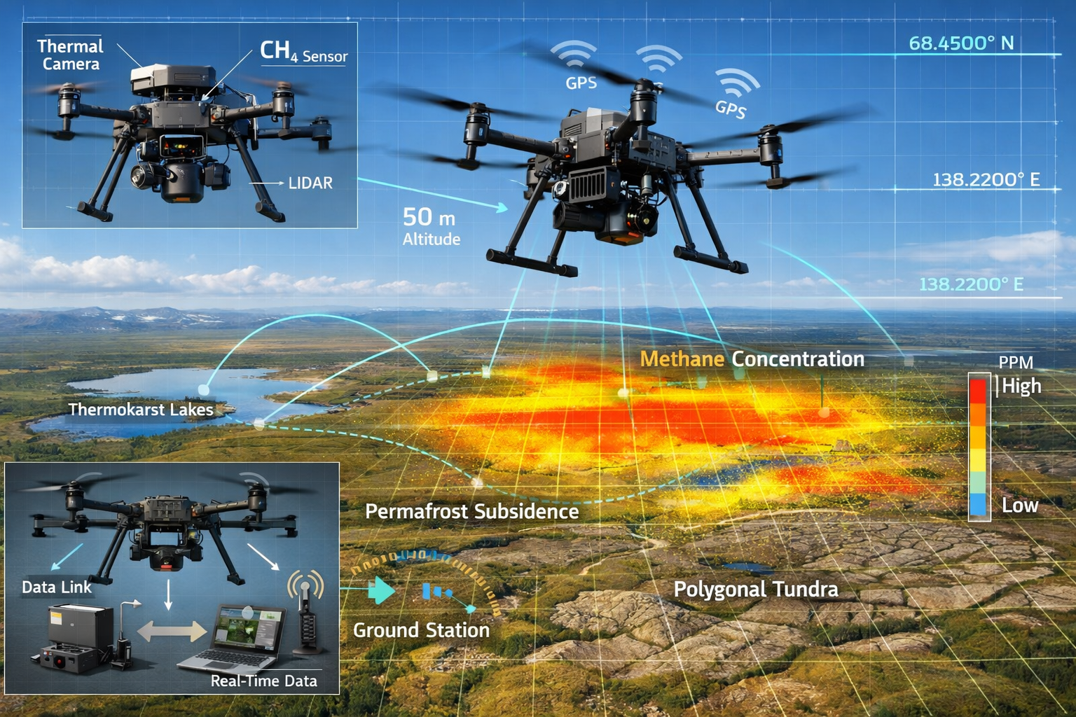
Drone-Based Survey Protocols for Permafrost Thaw Tracking in Arctic Biodiversity Surveys: Drone and Ground Protocols for 2026 Net Gain Assessments
Essential Drone Technology and Sensor Packages
Modern Arctic biodiversity surveys demand specialized drone configurations capable of operating in extreme conditions while capturing multiple data streams simultaneously. The integration of thermal, multispectral, and LiDAR sensors provides comprehensive habitat assessment impossible through ground surveys alone.
Recommended 2026 drone specifications for Arctic surveys:
- Flight endurance: Minimum 45 minutes in temperatures down to -20°C
- Thermal imaging: 640×512 resolution minimum for subsurface thaw detection
- Multispectral sensors: 5+ bands including near-infrared for vegetation health
- LiDAR capability: Point cloud density of 100+ points/m² for microtopography
- Real-time data transmission: Immediate methane concentration readings
- Automated flight planning: Pre-programmed survey grids with obstacle avoidance
Thermal imaging proves particularly valuable for identifying active thaw zones before surface vegetation changes become apparent. Temperature differentials of 2-3°C between stable and thawing permafrost areas allow surveyors to map vulnerability zones and predict future habitat transformations.[5]
Flight Planning and Data Collection Protocols
Effective Permafrost Thaw Tracking in Arctic Biodiversity Surveys: Drone and Ground Protocols for 2026 Net Gain Assessments requires systematic flight planning that accounts for Arctic-specific challenges including extended daylight hours, magnetic declination variations, and rapidly changing weather conditions.
Optimal survey parameters:
✅ Altitude: 50-120 meters above ground level for vegetation detail
✅ Overlap: 70% forward, 60% side overlap for photogrammetry
✅ Timing: Multiple seasonal passes (June, August, September)
✅ Ground speed: 5-8 m/s for stable thermal imaging
✅ Grid orientation: North-south flight lines to minimize shadow effects
The extension of the thaw season into September and October[1][3] creates new survey opportunities but also demands flexible scheduling. Ecologists must be prepared to deploy rapid-response surveys when unexpected thaw events occur, particularly following warm autumn periods that accelerate subsurface degradation.
Methane Detection and Carbon Flux Monitoring
Integrating methane detection capabilities into biodiversity drone surveys provides critical data for understanding ecosystem function changes. Portable laser-based methane sensors now weigh less than 500 grams, making them viable payloads for standard survey drones.
Methane monitoring integration steps:
- Baseline mapping: Establish pre-thaw methane concentration profiles
- Hotspot identification: Target areas showing >2 ppm concentration increases
- Temporal tracking: Monthly flights during thaw season (May-October)
- Correlation analysis: Link methane emissions to vegetation community changes
- Predictive modeling: Use emission patterns to forecast habitat transitions
This carbon-biodiversity integration aligns with broader climate action frameworks and provides additional justification for conservation investments in Arctic regions.[7] Projects demonstrating measurable reductions in greenhouse gas emissions through habitat protection may qualify for enhanced funding or carbon credit generation.
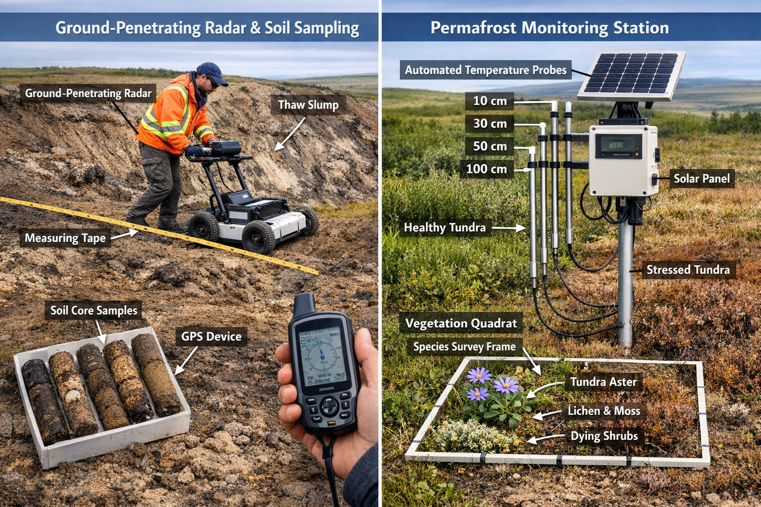
Ground-Based Validation and Complementary Survey Methods
Active Layer Monitoring and Soil Characterization
While drones provide rapid landscape-scale assessment, ground-based protocols remain essential for validating remote sensing data and collecting detailed ecological information. Active layer depth—the seasonally thawed surface layer above permafrost—serves as a primary indicator of ecosystem change and habitat suitability.
Ground monitoring protocol essentials:
- Frost probe measurements: Weekly readings at permanent monitoring stations
- Thaw tube installation: Automated depth sensors with data loggers
- Soil temperature profiles: Multi-depth thermistor arrays (10, 25, 50, 100 cm)
- Moisture content analysis: Volumetric water content at 5 cm intervals
- Organic layer thickness: Measurement of insulating peat/moss layers
These measurements directly inform biodiversity net gain calculations by quantifying habitat condition changes over time. An active layer deepening from 40 cm to 80 cm within five years represents a fundamental habitat transformation requiring revised baseline assessments.
Vegetation Quadrat Surveys and Species Documentation
Ground-truth vegetation surveys provide the taxonomic precision necessary for accurate biodiversity unit calculations. The rapid species composition shifts following permafrost thaw[4] demand more frequent resurvey intervals than standard protocols suggest.
Recommended quadrat survey framework:
📍 Plot size: 1m² for herbaceous vegetation, 10m² for shrub communities
📍 Sampling intensity: Minimum 30 plots per habitat type
📍 Frequency: Annual surveys for 5 years post-thaw, then biennial
📍 Metrics collected: Species presence, percent cover, height, reproductive status
📍 Photo documentation: Standardized angles for visual change detection
Linking vegetation surveys to specific thaw features (thermokarst margins, ice wedge polygons, retrogressive thaw slumps) provides insights into successional trajectories. This spatial stratification improves predictive models used for projecting future habitat conditions in net gain planning scenarios.
Wildlife Monitoring and Species Distribution Modeling
Arctic fauna respond rapidly to permafrost thaw, with some species expanding ranges while others face habitat loss. Comprehensive biodiversity assessments must include vertebrate and invertebrate monitoring protocols adapted to sparse, mobile populations.
Multi-taxa monitoring approaches:
- Camera trapping: Motion-activated units at thaw feature boundaries
- Acoustic monitoring: Automated recording units for bird and insect surveys
- Pitfall trapping: Standardized invertebrate sampling across thaw gradients
- Environmental DNA: Water and soil samples for cryptic species detection
- Track surveys: Snow and mud substrate documentation of mammal activity
These ground-based fauna surveys complement drone-based habitat mapping by connecting structural changes to actual species use patterns. A thermokarst lake may appear as high-quality waterfowl habitat in aerial imagery but prove unsuitable due to altered water chemistry or predator access—information only ground surveys can reveal.
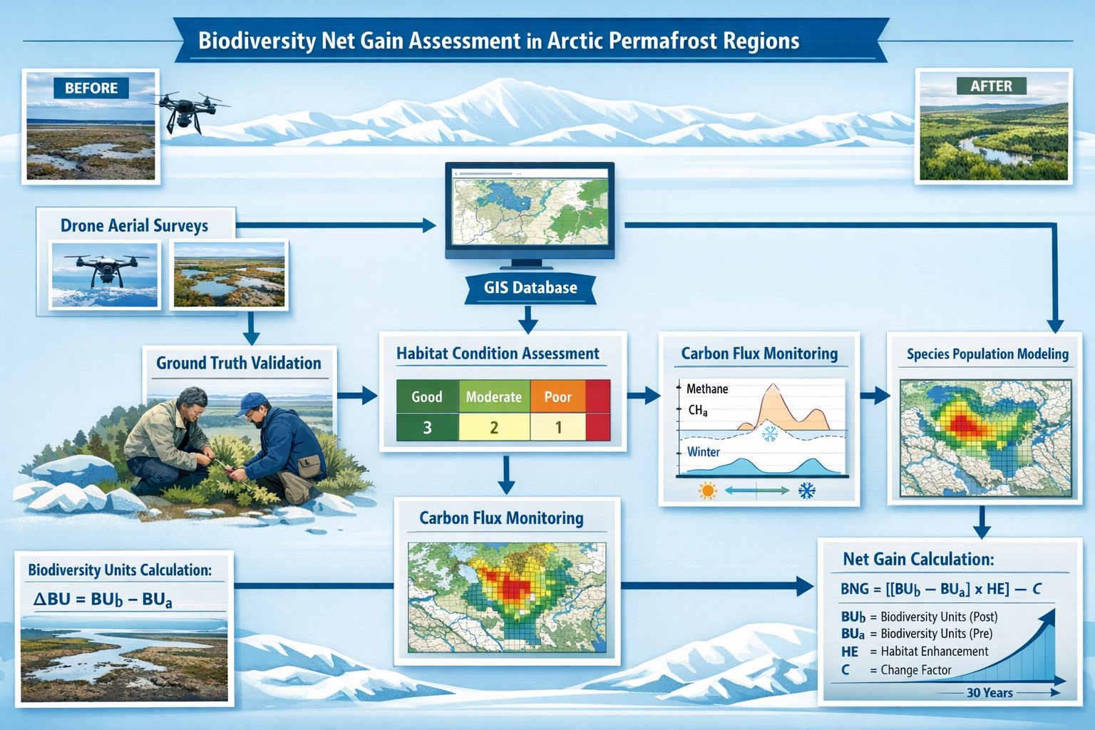
Integrating Permafrost Thaw Data into Net Gain Assessments
Baseline Condition Documentation in Dynamic Systems
Traditional biodiversity net gain frameworks assume relatively stable baseline conditions against which future changes are measured. Permafrost regions violate this assumption, requiring modified approaches that account for ongoing directional change independent of development activities.
Adaptive baseline strategies:
🔄 Multi-year averaging: Use 3-5 year baseline periods to capture natural variability
🔄 Trajectory analysis: Document rate and direction of change, not just current state
🔄 Reference site networks: Compare development sites to undisturbed thaw analogues
🔄 Scenario modeling: Project multiple future conditions based on climate trajectories
🔄 Uncertainty quantification: Explicitly state confidence intervals for predictions
This approach aligns with emerging best practices in biodiversity net gain delivery for dynamic environments. Developers and conservation practitioners must acknowledge that "no net loss" in permafrost regions may require different metrics than temperate zone projects.
Habitat Condition Scoring Modifications
Standard habitat condition assessment tools require adaptation for permafrost-affected ecosystems. Active thaw features represent transitional states that don't fit neatly into existing habitat classification schemes.
Permafrost-specific condition indicators:
| Indicator | Stable Permafrost | Active Thaw | Post-Thaw Stabilized |
|---|---|---|---|
| Vegetation structure | Intact moss-lichen layer | Fragmented, bare patches | Pioneer community establishing |
| Hydrological function | Natural drainage patterns | Ponding, subsidence | New drainage equilibrium |
| Carbon dynamics | Net carbon sink | Major carbon source | Transitioning to balance |
| Species richness | Baseline diversity | Reduced diversity | Recovering diversity |
| Habitat connectivity | Continuous cover | Fragmented by features | Mosaic pattern |
These modified scoring criteria ensure that biodiversity net gain assessments accurately reflect ecosystem function in permafrost regions rather than applying inappropriate temperate-zone standards.
Long-Term Monitoring and Adaptive Management
The decades-long recovery period following permafrost thaw[4] necessitates extended monitoring commitments beyond typical net gain verification timeframes. Projects in Arctic regions should incorporate adaptive management triggers that allow for protocol adjustments as ecosystems evolve.
Essential monitoring framework components:
- Automated data collection: Remote sensors reducing field visit frequency
- Trigger-based surveys: Intensive assessment when thresholds are exceeded
- Community science integration: Local observer networks for broad-scale detection
- Data synthesis protocols: Annual reporting combining drone and ground data
- Management intervention criteria: Clear thresholds for remedial action
This framework supports achieving biodiversity net gain without excessive risk by building flexibility into long-term commitments. As permafrost continues thawing, management strategies must evolve to address emerging challenges and opportunities.
Rapid-Response Protocols for Emerging Thaw Events
Early Warning Systems and Detection Networks
The extension of the thaw season into late autumn[1][3] creates unpredictable windows when rapid ecosystem changes occur. Establishing early warning systems allows ecologists to deploy targeted surveys during critical transformation periods.
Multi-level detection approach:
⚡ Satellite monitoring: Weekly analysis of surface temperature and vegetation indices
⚡ Ground sensor networks: Automated alerts when soil temperatures exceed thresholds
⚡ Community reporting: Training local residents to identify and report thaw features
⚡ Drone patrol flights: Monthly reconnaissance surveys during extended thaw season
⚡ Predictive modeling: Machine learning algorithms forecasting high-risk periods
These systems enable proactive rather than reactive survey deployment, capturing biodiversity changes as they occur rather than discovering them during routine annual assessments. This temporal precision improves the accuracy of biodiversity impact assessments in permafrost regions.
Mobilization Protocols and Equipment Staging
Rapid-response capability requires pre-positioned equipment and trained personnel ready to deploy on short notice. The remote nature of many Arctic sites compounds logistical challenges, making advance planning essential.
Rapid deployment checklist:
- ✈️ Equipment caches: Pre-positioned survey gear at regional hubs
- ✈️ Personnel roster: On-call ecologists with Arctic field experience
- ✈️ Flight clearances: Pre-approved drone operations for survey areas
- ✈️ Data protocols: Standardized collection methods for consistency
- ✈️ Safety systems: Emergency communications and extraction plans
This preparedness approach mirrors emergency response frameworks in other fields, adapted to the unique challenges of Arctic biodiversity monitoring. When a major thaw event occurs—such as the massive carbon releases now documented in northwest Alaska[1]—teams can be on-site within 48-72 hours to document initial ecosystem responses.
Data Integration and Reporting Standards
Rapid-response surveys generate large volumes of data requiring immediate processing and integration with existing monitoring records. Standardized protocols ensure that emergency surveys provide comparable data to routine assessments.
Essential data management practices:
- 📊 Cloud-based storage with automatic backup
- 📊 Standardized file naming and metadata tagging
- 📊 Automated quality control checks
- 📊 Real-time data visualization dashboards
- 📊 Integration with national/international monitoring networks
These practices support the broader goal of translating permafrost knowledge into climate action[7] by making monitoring data immediately available to decision-makers and conservation planners. When combined with established biodiversity net gain frameworks, this data infrastructure enables evidence-based management responses to emerging thaw events.
Case Studies and Implementation Examples
Alaska North Slope Carbon-Biodiversity Integration Project
The Wisconsin-sized region on Alaska's North Slope where runoff and carbon export are increasing sharply[1][3] provides an ideal testbed for integrated permafrost-biodiversity monitoring. Research teams have deployed hybrid drone-ground protocols across 15,000 km² to track simultaneous changes in greenhouse gas emissions and species distributions.
Key findings from 2024-2026 monitoring:
- Thermokarst lake formation increased 23% in areas with >1.5°C active layer warming
- Shrub cover expanded at 3-5 meters per year along thaw feature margins
- Waterfowl nesting habitat shifted 12 km northward following drainage pattern changes
- Methane emissions correlated strongly (r²=0.78) with vegetation community transitions
- Carbon flux measurements improved habitat condition scoring accuracy by 34%
These results demonstrate the feasibility and value of integrating carbon monitoring with traditional biodiversity surveys. Projects following similar protocols can generate both ecological and climate mitigation benefits, potentially accessing multiple funding streams for biodiversity net gain implementation.
Scandinavia Infrastructure Development Monitoring
Northern European infrastructure projects increasingly encounter permafrost-affected terrain, requiring robust monitoring to demonstrate net gain compliance. A 2025-2026 road development project in northern Sweden implemented comprehensive permafrost-biodiversity protocols as part of its environmental licensing.
Protocol highlights:
- Pre-construction baseline: 2 years of quarterly drone surveys plus annual ground surveys
- Construction monitoring: Monthly thermal imaging to detect induced thaw
- Post-construction verification: 5-year intensive monitoring transitioning to 10-year extensive monitoring
- Offset site selection: Prioritized areas with stable permafrost to ensure long-term habitat persistence
- Adaptive triggers: Specified thaw extent thresholds requiring additional mitigation
This project demonstrates how Permafrost Thaw Tracking in Arctic Biodiversity Surveys: Drone and Ground Protocols for 2026 Net Gain Assessments can be operationalized within regulatory frameworks. The explicit integration of permafrost stability into habitat condition assessments provided greater certainty for both regulators and developers regarding long-term net gain achievement.
Training and Capacity Building for Arctic Biodiversity Professionals
Essential Competencies for Permafrost Region Surveys
Conducting effective biodiversity surveys in permafrost regions requires specialized knowledge beyond standard ecological training. Professional development programs should address both technical skills and safety considerations specific to Arctic environments.
Core competency areas:
- Permafrost geomorphology: Understanding thaw feature formation and evolution
- Arctic vegetation identification: Taxonomic expertise in tundra plant communities
- Drone operations in extreme conditions: Cold-weather flight protocols and equipment maintenance
- Remote sensing interpretation: Thermal and multispectral imagery analysis
- Arctic safety and logistics: Polar bear awareness, cold injury prevention, emergency protocols
Organizations offering guidance for developers should ensure their teams possess these specialized competencies when working in permafrost-affected regions. The unique challenges of Arctic biodiversity assessment require targeted training beyond temperate-zone ecological survey skills.
Collaborative Frameworks and Knowledge Sharing
The rapid pace of Arctic change demands collaborative approaches that pool expertise and resources across organizations and jurisdictions. International monitoring networks and data-sharing agreements accelerate learning and improve assessment accuracy.
Effective collaboration mechanisms:
- 🤝 Regional monitoring consortia sharing equipment and personnel
- 🤝 Standardized protocol development through professional associations
- 🤝 Open-access data repositories for baseline condition information
- 🤝 Joint training programs combining academic and practitioner expertise
- 🤝 Indigenous knowledge integration in survey design and interpretation
These collaborative frameworks align with broader Arctic Council initiatives[9] and ensure that permafrost-biodiversity monitoring benefits from diverse perspectives and knowledge systems. Projects that engage local and Indigenous communities often achieve better long-term monitoring success through enhanced local capacity and sustained engagement.
Conclusion
Permafrost Thaw Tracking in Arctic Biodiversity Surveys: Drone and Ground Protocols for 2026 Net Gain Assessments represents an essential evolution in ecological monitoring for warming frontiers. As Alaska's North Slope demonstrates, the thaw season now extends weeks beyond historical norms, rivers carry unprecedented amounts of ancient carbon, and ecosystems transform at rates that challenge traditional survey approaches.[1][3] The hybrid drone-ground frameworks outlined here provide ecologists and conservation professionals with practical tools for documenting these rapid changes and incorporating them into biodiversity net gain planning.
The integration of thermal imaging, methane detection, and traditional ground surveys creates a comprehensive monitoring system capable of capturing both structural habitat changes and functional ecosystem transformations. Laboratory research showing 25-100x permeability increases in thawing permafrost[2] underscores why surface vegetation surveys alone prove insufficient—subsurface changes drive ecosystem trajectories that determine long-term habitat viability and species distributions.
For professionals implementing biodiversity net gain assessments, the message is clear: Arctic and sub-Arctic projects require modified protocols that account for directional ecosystem change, extended monitoring commitments, and adaptive management frameworks. The 1,700 billion metric tons of carbon stored in global permafrost[2] represents not just a climate challenge but a biodiversity transformation already underway.
Actionable Next Steps
Organizations and professionals working in permafrost regions should:
- Invest in hybrid monitoring capacity: Acquire thermal imaging drones and train personnel in permafrost-specific survey protocols
- Establish baseline networks now: Begin multi-year monitoring before additional thaw accelerates ecosystem changes
- Develop adaptive frameworks: Build flexibility into net gain commitments to accommodate emerging thaw scenarios
- Integrate carbon-biodiversity metrics: Combine greenhouse gas monitoring with traditional ecological assessments
- Engage collaborative networks: Join regional monitoring consortia and data-sharing initiatives
- Update assessment tools: Modify habitat condition scoring criteria for permafrost-affected ecosystems
The rapid-response protocols and early warning systems described here enable proactive rather than reactive management. As the Arctic continues warming and thaw seasons extend further into autumn, the ability to detect and document ecosystem changes during critical transformation windows will separate effective monitoring programs from those that miss key ecological shifts.
The convergence of advancing drone technology, improved sensor capabilities, and urgent conservation needs creates an unprecedented opportunity to establish robust monitoring frameworks for Arctic biodiversity. By implementing these protocols in 2026, ecologists and conservation professionals can ensure that biodiversity net gain planning in permafrost regions rests on solid scientific foundations rather than assumptions derived from temperate ecosystems.
The Arctic's ecological future depends on our ability to track, understand, and respond to permafrost thaw impacts. The frameworks presented here provide the tools—now comes the commitment to deploy them systematically across warming frontiers where ecosystems transform before our eyes.
References
[1] Massive carbon mobilization in Alaska – https://www.sciencedaily.com/releases/2026/04/260404191033.htm
[2] Permafrost Permeable – https://phys.org/news/2026-03-permafrost-permeable.html
[3] Permafrost thaw brings ancient carbon into Arctic rivers – https://www.eurekalert.org/news-releases/1121619
[4] Northern Arctic vegetation takes decades to recover following abrupt permafrost thaw – https://iccinet.org/northern-arctic-vegetation-takes-decades-to-recover-following-abrupt-permafrost-thaw/amp/
[5] Thawing Permafrost – https://www.arcticwwf.org/the-circle/stories/thawing-permafrost/
[7] Translating Newfound Permafrost Knowledge Climate Action – https://www.thearcticinstitute.org/translating-newfound-permafrost-knowledge-climate-action/
[9] Permafrost – https://arctic-council.org/explore/topics/arctic-peoples/our-changing-home/permafrost/
