
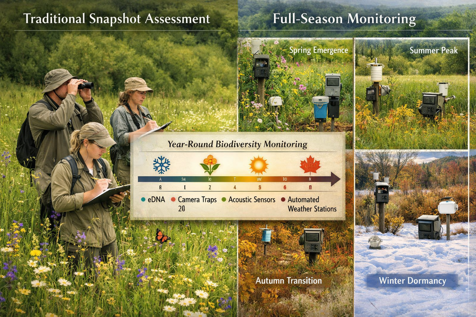
Imagine trying to understand a forest's health by visiting it just once in July. You might miss the spring wildflower explosion, the autumn migration patterns, and the winter survival strategies that define the ecosystem. Yet this "snapshot" approach has dominated biodiversity surveys for decades. In 2026, that paradigm is shifting dramatically as ecologists embrace Full-Season Biodiversity Monitoring: Optimizing 2026 Survey Strategies Beyond Snapshot Assessments to capture the complete ecological story.
The traditional one-off survey model—where teams visit a site for a single day or week—creates dangerous blind spots. Species that emerge only in early spring remain undetected. Migratory populations pass through unnoticed. Critical ecosystem pulses that signal environmental stress or recovery go unrecorded. As Europe launches groundbreaking pilot projects and establishes new monitoring frameworks this year, the conservation community is recognizing that understanding biodiversity requires observing ecosystems breathe through their full seasonal cycles.
This comprehensive guide explores how Full-Season Biodiversity Monitoring: Optimizing 2026 Survey Strategies Beyond Snapshot Assessments transforms ecological assessment from static photographs into dynamic documentaries, providing the temporal resolution needed for effective conservation decisions.
Key Takeaways
🌿 Continuous monitoring captures seasonal dynamics that single-visit surveys miss, including early spring baselines, migration patterns, and ecosystem responses to environmental changes throughout the year.
🔬 Innovative technologies enable year-round data collection through automated sensors, DNA metabarcoding, passive acoustic monitoring, and satellite remote sensing that operate independently across all seasons.
📊 Standardized Essential Biodiversity Variables (EBVs) provide the framework for comparable, harmonized data collection across regions and throughout monitoring periods, replacing fragmented national programs.
🤝 Integrated governance structures like the proposed European Biodiversity Observation Coordination Center coordinate workflows, align monitoring with policy needs, and break down data silos.
⚡ Early intervention signals emerge from continuous datasets, allowing conservationists to detect ecological changes quickly and implement protective measures before irreversible damage occurs.
Why Traditional Snapshot Assessments Fall Short in 2026
Traditional biodiversity surveys typically involve field teams visiting sites during optimal weather windows—usually late spring or summer—to record species presence and abundance. While these assessments provide valuable baseline data, they suffer from fundamental limitations that compromise conservation planning.
Temporal blindness represents the most critical flaw. A survey conducted in July captures summer-active species but misses spring ephemeral plants, early-season pollinators, autumn migrants, and winter specialists. This creates a distorted picture of actual biodiversity richness and ecosystem function.
Phenological mismatches compound the problem. Climate change shifts species' seasonal timing, meaning traditional survey windows may no longer align with peak activity periods. A butterfly survey scheduled for historical emergence dates might occur weeks before or after the actual population peak in 2026.
Intervention signal detection requires temporal resolution that snapshots cannot provide. When habitat restoration begins or environmental stressors emerge, ecologists need continuous data to track ecosystem responses, identify early warning signs, and adjust management strategies accordingly. Single-visit surveys conducted months apart lack the granularity to detect these critical signals.
For developers and planners working on biodiversity net gain assessments, snapshot data may underestimate baseline biodiversity, leading to inadequate compensation requirements and failed conservation outcomes.
Understanding Full-Season Biodiversity Monitoring: Optimizing 2026 Survey Strategies
Full-season monitoring represents a paradigm shift from occasional site visits to continuous ecological observation throughout the entire annual cycle. This approach captures the complete temporal dynamics of ecosystems, revealing patterns invisible to traditional methods.
Core Principles of Continuous Monitoring
Seasonal coverage ensures data collection spans all ecological seasons—not just calendar seasons. This includes early spring emergence periods, summer activity peaks, autumn transitions, and winter dormancy phases. Each season contributes unique biodiversity information essential for comprehensive assessment.
Automated data collection reduces dependence on weather-dependent field visits. Technologies operate continuously regardless of conditions, building datasets with consistent temporal resolution. This automation also dramatically reduces the carbon footprint associated with repeated site visits.
Multi-method integration combines complementary approaches to capture different biodiversity components. Visual surveys detect conspicuous species, acoustic monitoring captures vocalizing animals, eDNA sampling reveals cryptic organisms, and remote sensing tracks landscape-scale patterns—all operating simultaneously throughout the monitoring period.
Standardized protocols ensure data comparability across sites, regions, and time periods. The framework of 84 Essential Biodiversity Variables (EBVs) identified for Europe's harmonized monitoring system provides this standardization backbone, enabling consistent measurement of species populations, ecosystem structure, and community composition [2].
The 2026 Monitoring Revolution
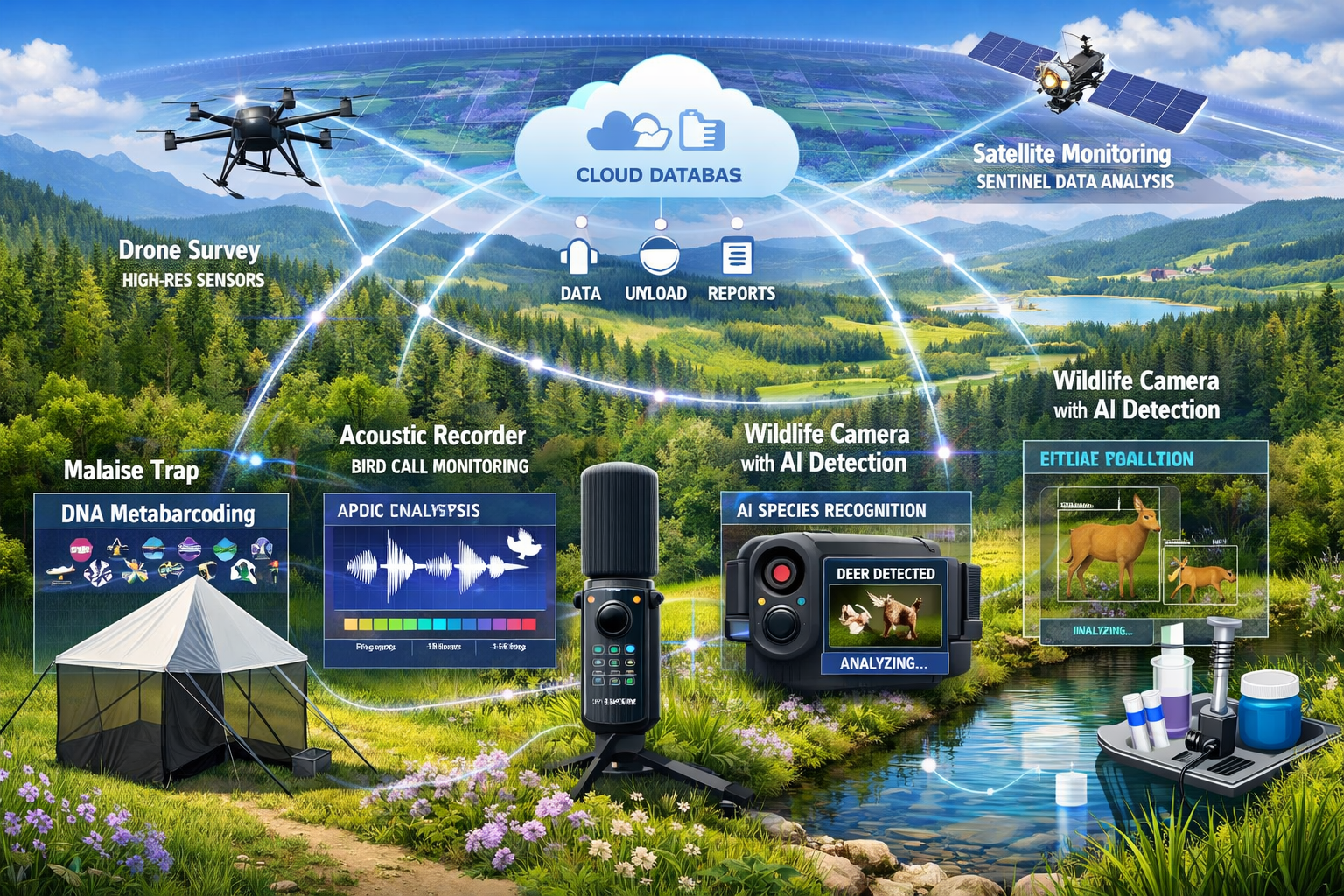
Three new Biodiversa+ pilot projects launching in 2026 exemplify this transformation. These initiatives implement continuous, full-season monitoring across insects, ponds, and forests using innovative technologies rather than traditional point-based surveys [1].
The insect monitoring pilot deploys Malaise traps with DNA metabarcoding to detect thousands of species—including elusive pollinators—throughout the monitoring season. These traps operate continuously with negligible impact on insect populations, capturing only a tiny fraction of local communities while providing comprehensive species inventories impossible through visual observation alone [1].
The BiodivPond project addresses a critical gap in freshwater monitoring. Despite supporting up to 70% of freshwater biodiversity in European landscapes, ponds remain undermonitored due to their abundance and dispersal [1]. Continuous eDNA sampling and passive acoustic monitoring combined with field surveys capture species richness, genetic diversity, and ecosystem functions across hundreds of ponds in real-time, supporting ongoing assessment rather than seasonal snapshots.
The SenseForest pilot leverages remote sensing technologies from high-resolution drones to Sentinel satellites to provide "wall-to-wall" landscape-scale information across forest ecosystems. This enables continuous cross-border monitoring with harmonized protocols, addressing the limitation of traditional costly, point-based field inventories that miss dynamics across seasons [1].
Technologies Enabling Full-Season Biodiversity Monitoring: Optimizing 2026 Survey Strategies
The technological foundation supporting year-round monitoring has matured significantly, making continuous assessment practical and cost-effective for 2026 implementation.
Automated Digital Sensors and AI
Acoustic monitoring devices record bird calls, bat echolocation, amphibian choruses, and insect sounds continuously throughout seasons. Modern recorders operate for months on solar power, capturing soundscapes that reveal species presence, abundance, breeding activity, and behavioral patterns across temporal scales.
Wildlife cameras equipped with AI-powered species recognition provide continuous visual monitoring without human presence. These devices detect mammals, birds, and even insects, recording activity patterns, population dynamics, and behavioral responses to environmental changes throughout the year.
Biological and weather radars track insect migrations, bird movements, and atmospheric conditions simultaneously. This integration reveals how weather patterns influence species movements and helps distinguish biological signals from environmental noise in monitoring datasets.
TinyML (Tiny Machine Learning) devices and optical AI chips represent emerging tools identified in the 2026 Global Horizon Scan [5]. These technologies enable real-time biodiversity detection in remote landscapes without internet connectivity, potentially transforming full-season monitoring in areas with limited digital infrastructure.
DNA Metabarcoding and eDNA Analysis
Environmental DNA (eDNA) sampling captures genetic material shed by organisms into water, soil, and air. Analyzed through metabarcoding, these samples reveal species presence including rare, cryptic, and nocturnal organisms that evade traditional surveys.
The sensitivity and repeatability of eDNA methods make them ideal for continuous monitoring. Samples collected weekly or monthly throughout seasons build comprehensive species inventories while detecting temporal patterns in abundance and distribution. The BiodivPond project demonstrates this approach at scale, engaging citizen science volunteers to collect samples from hundreds of ponds continuously [1].
Malaise traps combined with DNA metabarcoding provide particularly powerful insect monitoring. Operating passively throughout seasons, these traps capture flying insects that are then identified through genetic analysis, revealing thousands of species including many that lack field-identifiable characteristics [1].
Remote Sensing and Satellite Observation
Satellite-based habitat observation provides continuous landscape-scale monitoring impossible through ground surveys. Sentinel satellites deliver regular imagery revealing vegetation health, land cover changes, water quality, and ecosystem structure throughout the year.
High-resolution drone surveys complement satellite data with detailed information on specific sites. Drones equipped with multispectral and thermal sensors detect vegetation stress, map habitat structure, and monitor restoration progress with temporal resolution matching management needs.
The SenseForest pilot integrates these technologies to provide harmonized cross-border forest monitoring, demonstrating how remote sensing enables wall-to-wall coverage that captures seasonal dynamics across entire landscapes [1].
For developers implementing biodiversity impact assessments, these technologies offer unprecedented ability to track habitat changes and verify conservation outcomes throughout project timelines.
Implementing Full-Season Biodiversity Monitoring: Optimizing 2026 Survey Strategies in Practice
Transitioning from snapshot assessments to continuous monitoring requires strategic planning, appropriate technology selection, and integration with existing conservation frameworks.
Designing Effective Full-Season Protocols
Establish clear monitoring objectives aligned with conservation goals or regulatory requirements. Are you tracking habitat restoration progress? Assessing development impacts? Monitoring protected species? Objectives determine which biodiversity components require continuous observation versus periodic assessment.
Select appropriate temporal resolution based on ecological processes of interest. Breeding bird populations may require daily acoustic monitoring during nesting seasons but weekly sampling suffices during migration periods. Vegetation monitoring through satellite imagery might occur biweekly during growing seasons but monthly during dormancy.
Integrate multiple monitoring methods to capture different biodiversity dimensions. Combine automated sensors (cameras, acoustic recorders) with periodic eDNA sampling and seasonal field surveys. This integration provides cross-validation while capturing species that different methods detect preferentially.
Align with Essential Biodiversity Variables to ensure data compatibility with broader monitoring networks. The 84 EBVs identified for Europe provide standardized measurement frameworks for species populations, ecosystem structure, and community composition [2]. Using these variables enables data sharing and comparison across projects.
Technology Deployment Strategies
Start with pilot deployments before full-scale implementation. Test equipment performance across seasons, refine protocols based on initial results, and identify logistical challenges specific to your sites. The three Biodiversa+ pilots launching in 2026 provide models for this phased approach [1].
Ensure adequate power and data management infrastructure. Solar panels extend sensor operation through winter months. Cellular or satellite connectivity enables remote data retrieval, while local storage provides backup during connectivity gaps. Cloud-based data pipelines facilitate analysis and sharing.
Maintain equipment throughout monitoring periods. Schedule regular site visits for equipment checks, battery replacement, data downloads, and sensor cleaning. Automated systems still require periodic maintenance to ensure continuous data quality.
Calibrate and validate automated identifications. AI-powered species recognition continues improving but requires validation through expert review of subsamples. DNA metabarcoding reference libraries need regional customization to ensure accurate species identification.
Integration with Biodiversity Net Gain Requirements
For projects subject to biodiversity net gain regulations, full-season monitoring offers significant advantages over traditional snapshot surveys.
Baseline assessments gain accuracy when conducted across full annual cycles. Species richness, habitat condition, and ecosystem function measurements based on continuous data provide more defensible baselines than single-visit surveys, potentially revealing higher biodiversity values that increase net gain requirements but ensure adequate conservation compensation.
Impact monitoring becomes more sensitive to development effects. Continuous data collection before, during, and after construction reveals temporal patterns in species responses, habitat degradation, and ecosystem disruption that inform adaptive management.
Restoration verification improves through ongoing monitoring of created or enhanced habitats. Rather than waiting years between assessment points, continuous monitoring tracks vegetation establishment, colonization by target species, and ecosystem function development, enabling early intervention when restoration trajectories deviate from targets.
Developers can explore how to achieve 10% biodiversity net gain through monitoring strategies that demonstrate genuine ecological improvement over time.
European Monitoring Framework: Governance and Coordination for 2026
Individual projects implementing full-season monitoring contribute to broader efforts establishing harmonized biodiversity observation across Europe. Understanding this emerging framework helps position local initiatives within continental conservation infrastructure.
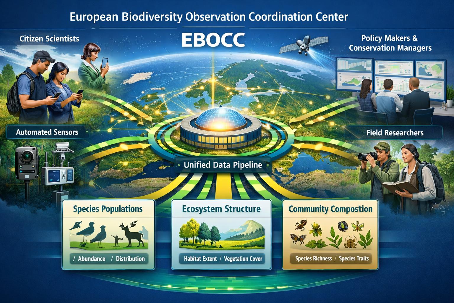
The European Biodiversity Observation Coordination Center (EBOCC)
The proposed European Biodiversity Observation Coordination Center (EBOCC) addresses a fundamental challenge: "Europe has hundreds of monitoring programs, but the data are often siloed, incompatible, or incomplete" [3]. This central governance body would coordinate workflows, harmonize methods, ensure transparent data governance, and align monitoring with EU policy needs.
Key EBOCC functions include:
- Protocol standardization ensuring monitoring methods produce comparable data across countries and ecosystems
- Data integration creating unified pipelines that combine professional field notes, public reports, electronic sensors, DNA samples, and satellite imagery into scalable EBV datasets [3]
- Quality assurance establishing validation procedures that maintain data reliability while enabling rapid sharing
- Policy alignment ensuring monitoring outputs address decision-maker needs for biodiversity reporting, conservation planning, and environmental regulation
Biodiversity Monitoring Week 2026
Scheduled for May 4-8 in Montpellier, France, Biodiversity Monitoring Week 2026 represents the first event of its kind [4]. Nine thematic areas cover terrestrial, marine, and freshwater monitoring, data management, mass monitoring approaches, governance, and capacity-building.
This gathering provides opportunities to:
- Learn from pilot project experiences implementing full-season monitoring
- Explore emerging technologies and analytical approaches
- Contribute to protocol development for harmonized European monitoring
- Network with researchers, practitioners, and policymakers advancing biodiversity observation
For organizations developing monitoring strategies, engagement with this community accelerates learning and ensures alignment with evolving best practices.
Citizen Science Integration
Citizen science programs represent essential components of scaled full-season monitoring. The BiodivPond project demonstrates this approach, engaging volunteers in hundreds of ponds for ongoing eDNA and acoustic sampling [1]. This integration of human expertise with technological innovation enables large-scale, continuous biodiversity assessment beyond what professional teams could achieve through snapshot surveys alone.
Effective citizen science programs for continuous monitoring require:
- Simple, repeatable protocols that volunteers can implement reliably
- Training and support ensuring data quality and volunteer retention
- Technology assistance providing equipment, apps, and data submission platforms
- Feedback and recognition showing volunteers how their contributions advance conservation
Organizations can learn from established programs while developing monitoring approaches suited to local contexts and volunteer communities.
Data Management and Analysis for Continuous Monitoring
The shift to full-season monitoring generates vastly larger datasets than traditional surveys, requiring robust data management and analytical approaches.
Unified Data Pipelines
Integrated data systems combine diverse data streams—sensor outputs, DNA sequences, satellite imagery, field observations—into coherent datasets organized around Essential Biodiversity Variables. These pipelines automate quality control, species identification validation, and preliminary analysis, enabling rapid data availability for decision-making [3].
Cloud-based platforms facilitate data storage, processing, and sharing while providing computational resources for intensive analyses like DNA metabarcoding bioinformatics or satellite image classification. Open-access platforms support transparency and enable independent verification of monitoring results.
Metadata standards ensure future users understand data collection methods, temporal coverage, spatial resolution, and limitations. Comprehensive metadata transforms raw monitoring outputs into usable information for conservation planning and policy development.
Analytical Approaches for Temporal Data
Time-series analysis reveals trends, seasonal patterns, and anomalies in continuous monitoring data. Statistical methods detect significant changes in species abundance, habitat condition, or ecosystem function while accounting for natural variability and seasonal cycles.
Early warning indicators emerge from continuous datasets, alerting managers to developing problems before they become crises. Declining species detections, shifting phenology patterns, or changing community composition may signal environmental stress requiring investigation and potential intervention.
Intervention effect assessment becomes more rigorous with continuous monitoring. Before-after-control-impact (BACI) designs gain statistical power when based on continuous data rather than single pre- and post-intervention surveys, enabling confident attribution of observed changes to management actions.
For planners working on biodiversity plans for development projects, these analytical capabilities provide stronger evidence for decision-making and adaptive management.
Cost-Benefit Considerations and Resource Optimization
Full-season monitoring requires greater upfront investment than snapshot surveys but delivers substantial long-term value through improved data quality and conservation outcomes.
Initial Investment Requirements
Equipment costs vary widely based on technology selection and monitoring scale. Basic acoustic recorders and wildlife cameras cost hundreds to thousands of pounds per unit. DNA metabarcoding requires laboratory analysis fees. Satellite imagery may be freely available (Sentinel) or require commercial subscriptions for higher resolution.
Installation and setup demands field time for equipment deployment, site preparation, and initial calibration. Remote sites with limited access increase these costs. However, this investment occurs primarily at project initiation rather than repeatedly throughout monitoring periods.
Data infrastructure including cloud storage, processing platforms, and analytical software represents ongoing costs but scales efficiently across projects. Shared infrastructure among multiple monitoring initiatives reduces per-project expenses.
Long-Term Value and Efficiency
Reduced field visit frequency lowers travel costs, carbon emissions, and staff time requirements. Automated sensors collect data continuously while field teams focus on equipment maintenance, data validation, and strategic surveys targeting specific questions.
Higher data quality and completeness improve conservation decision-making, potentially preventing costly management failures. Detecting ecological problems early through continuous monitoring enables less expensive interventions than addressing advanced degradation discovered through infrequent surveys.
Multi-purpose data streams serve diverse conservation needs simultaneously. Continuous monitoring supporting biodiversity net gain compliance also provides data for protected species monitoring, habitat condition assessment, climate change research, and public engagement—multiplying return on investment.
Regulatory efficiency may emerge as continuous monitoring becomes standard practice. Demonstrating ongoing compliance through automated data collection could streamline permitting, reduce reporting burdens, and provide stronger legal defense of conservation claims than periodic snapshot assessments.
Organizations exploring biodiversity credits and units may find continuous monitoring strengthens market confidence in habitat creation and management claims.
Practical Implementation Roadmap for 2026
Organizations ready to implement full-season monitoring can follow this strategic roadmap adapted from 2026 pilot project experiences.
Phase 1: Planning and Design (Months 1-3)
✅ Define monitoring objectives aligned with conservation goals, regulatory requirements, or research questions
✅ Identify target biodiversity components requiring continuous versus periodic assessment
✅ Select appropriate technologies based on target species, habitats, budget, and technical capacity
✅ Design sampling protocols specifying temporal resolution, spatial coverage, and quality assurance procedures
✅ Establish data management systems including storage, processing, and sharing infrastructure
✅ Secure necessary permissions for equipment deployment, site access, and data collection
Phase 2: Pilot Deployment (Months 4-9)
✅ Deploy equipment at pilot sites representing key habitat types and monitoring challenges
✅ Conduct initial field surveys providing baseline data and validating automated detection methods
✅ Test data collection and retrieval procedures ensuring reliable operation across seasons
✅ Refine protocols based on pilot results, equipment performance, and logistical experiences
✅ Train staff and volunteers in equipment maintenance, data validation, and analytical approaches
Phase 3: Full Implementation (Months 10-24)
✅ Scale deployment to complete monitoring network based on refined protocols
✅ Establish maintenance schedules ensuring continuous operation and data quality
✅ Implement analytical workflows producing regular reports for stakeholders and decision-makers
✅ Integrate with broader monitoring networks contributing data to regional or national systems
✅ Communicate results to stakeholders, policymakers, and public audiences demonstrating conservation outcomes
Phase 4: Adaptive Management (Ongoing)
✅ Review monitoring effectiveness annually, assessing whether objectives are being met
✅ Update protocols incorporating technological advances and methodological improvements
✅ Respond to monitoring findings through conservation interventions, habitat management, or policy changes
✅ Contribute to monitoring community sharing experiences, protocols, and lessons learned
Organizations can access professional support through biodiversity surveyors experienced in implementing continuous monitoring programs.
Case Applications: From Theory to Practice
Understanding how full-season monitoring applies across different contexts helps organizations design effective programs.
Development Projects and Impact Assessment
Construction projects spanning multiple years benefit enormously from continuous monitoring. Traditional approaches conduct pre-construction surveys, pause monitoring during construction, then resume post-completion—missing critical dynamics during the impact period.
Full-season monitoring maintains observation throughout project timelines, revealing:
- Species displacement patterns as construction progresses
- Habitat degradation rates informing mitigation timing
- Effectiveness of protective measures like exclusion fencing or seasonal work restrictions
- Early colonization of created habitats by target species
This continuous evidence supports adaptive management, regulatory compliance demonstration, and defensible claims about biodiversity outcomes.
Protected Area Management
Nature reserves and protected areas increasingly adopt continuous monitoring to track conservation effectiveness and detect emerging threats. Automated sensors provide year-round surveillance impossible through periodic warden patrols.
Applications include:
- Protected species monitoring capturing breeding success, population trends, and habitat use patterns
- Invasive species detection enabling rapid response before establishment
- Visitor impact assessment revealing disturbance patterns and informing access management
- Climate change response tracking documenting phenological shifts and range changes
Agricultural Landscapes and Sustainable Farming
Farmers participating in agri-environment schemes or pursuing sustainable intensification benefit from continuous monitoring demonstrating environmental outcomes. Acoustic monitoring tracks farmland bird populations, eDNA sampling reveals soil biodiversity, and satellite imagery documents habitat features—all operating throughout farming cycles.
This evidence supports participation in programs like the Sustainable Farming Incentive while informing management decisions that balance production and conservation.
Future Directions: Beyond 2026
Full-season biodiversity monitoring continues evolving as technologies advance and ecological understanding deepens.
Artificial intelligence will increasingly automate species identification from images, sounds, and DNA sequences, reducing expert review requirements while maintaining accuracy. Real-time alerts when rare species are detected or concerning trends emerge will enable immediate conservation responses.
Sensor miniaturization and cost reduction will make continuous monitoring accessible to smaller organizations and individual landowners. Consumer-grade devices with professional-quality data output will democratize biodiversity observation.
Integration with climate and environmental monitoring will reveal complex interactions between biodiversity, weather patterns, pollution, and land use—advancing ecosystem understanding and predictive modeling capabilities.
Standardization and interoperability will mature as frameworks like the Essential Biodiversity Variables become widely adopted, enabling seamless data sharing across projects, regions, and countries. Continental-scale biodiversity assessment will become routine rather than exceptional.
Policy integration will strengthen as continuous monitoring data directly informs conservation regulations, development planning, and environmental reporting. Real-time biodiversity status dashboards may eventually guide decision-making as routinely as economic indicators.
Organizations establishing full-season monitoring programs in 2026 position themselves at the forefront of this transformation, building expertise and datasets that will grow increasingly valuable as the conservation community embraces continuous observation as standard practice.
Conclusion
The transition from snapshot assessments to Full-Season Biodiversity Monitoring: Optimizing 2026 Survey Strategies Beyond Snapshot Assessments represents a fundamental shift in how we observe, understand, and protect nature. Single-visit surveys that dominated the past century cannot capture the seasonal pulses, temporal dynamics, and intervention signals essential for effective conservation in an era of rapid environmental change.
The technologies enabling this transformation—automated sensors, DNA metabarcoding, passive acoustic monitoring, satellite remote sensing—have matured to the point where continuous observation is practical and cost-effective. The three Biodiversa+ pilots launching in 2026 demonstrate implementation pathways across insects, ponds, and forests. The proposed European Biodiversity Observation Coordination Center provides governance frameworks for harmonized continental monitoring. The 84 Essential Biodiversity Variables offer standardized measurement protocols ensuring data compatibility and comparability.
For ecologists, conservation managers, developers, and policymakers, full-season monitoring delivers unprecedented ability to detect early warning signals, track ecosystem responses to interventions, verify conservation outcomes, and make evidence-based decisions grounded in complete temporal understanding rather than fragmentary snapshots.
Next Steps for Implementation
Organizations ready to embrace continuous monitoring should:
- Assess current monitoring approaches identifying temporal gaps and opportunities for automation
- Engage with pilot projects and monitoring communities learning from early implementers
- Start small with pilot deployments testing technologies and refining protocols before full-scale implementation
- Invest in data infrastructure ensuring capacity to manage, analyze, and share continuous datasets
- Align with emerging standards positioning programs to contribute to broader monitoring networks
- Communicate results effectively demonstrating the value of continuous observation to stakeholders and decision-makers
The shift to full-season biodiversity monitoring is not merely a technical upgrade—it represents a more honest, complete, and effective approach to understanding the living world we seek to protect. As 2026 unfolds with new pilots, frameworks, and technologies coming online, the opportunity exists to establish monitoring programs that will guide conservation for decades to come.
For professional guidance implementing full-season monitoring strategies tailored to your specific context, contact biodiversity surveying specialists experienced in cutting-edge assessment approaches.
References
[1] From Insects To Forests Three New Pilots To Strengthen Monitoring – https://www.biodiversa.eu/2025/12/19/from-insects-to-forests-three-new-pilots-to-strengthen-monitoring/
[2] 2026 02 Roadmap Outlines Biodiversity Variables Europe – https://phys.org/news/2026-02-roadmap-outlines-biodiversity-variables-europe.html
[3] Roadmap For Europes Biodiversity Monitoring System – https://www.idiv.de/roadmap-for-europes-biodiversity-monitoring-system/
[4] Biodiversity Monitoring Week 2026 To Take Place In Montpellier – https://www.gbif.se/news/2026/biodiversity-monitoring-week-2026-to-take-place-in-montpellier/
[5] Whats Next For Biodiversity Conservation Insights From The 2026 Horizon Scan – https://www.unep-wcmc.org/en/news/whats-next-for-biodiversity-conservation-insights-from-the-2026-horizon-scan
