
The world's biodiversity is vanishing at an unprecedented rate. Species disappear before scientists can even catalog them. Habitats degrade faster than conservation efforts can restore them. In this race against time, ecology survey strategy under accelerating biodiversity loss: using scenarios to prioritise what and where to monitor has become critical for making every survey count.
Field ecologists and biodiversity surveyors face a harsh reality in 2026: limited budgets, shrinking timelines, and expanding conservation needs. Not every species can be monitored. Not every habitat can receive equal attention. The question becomes: how do professionals decide where to focus their efforts for maximum conservation impact?
This challenge has given rise to scenario-based planning—a strategic approach that uses predictive models of biodiversity futures to guide survey priorities. By understanding which species, habitats, and pressures matter most under different "bending the curve" scenarios, surveyors can allocate resources where they'll deliver the greatest policy-relevant insights.
Key Takeaways
- Scenario modeling helps surveyors identify which taxa and habitats face the highest extinction risk under different future trajectories, enabling strategic resource allocation
- Pressure indicators (habitat loss, climate change, invasive species) should be prioritized based on their relative impact in regional biodiversity scenarios
- Policy-relevant monitoring focuses survey efforts on species and ecosystems that inform national and international conservation targets
- Risk-based prioritization ensures limited survey budgets target the most vulnerable and ecologically significant components of nature
- Integration with frameworks like Biodiversity Net Gain strengthens the connection between field data and conservation outcomes
Understanding Biodiversity Scenarios and "Bending the Curve"
What Are Biodiversity Scenarios? 🌍
Biodiversity scenarios are science-based projections that model how nature might change over the coming decades under different human actions and policy choices. These scenarios typically project trends from 2020 through 2050 or beyond, examining variables like:
- Species abundance and extinction rates
- Habitat extent and quality
- Ecosystem service provision
- Key pressure dynamics (land-use change, pollution, climate impacts)
The most widely referenced scenarios come from international research collaborations that model "business-as-usual" trajectories versus transformative conservation interventions. These projections help answer: If we continue current practices, where will biodiversity be in 2050? What if we implement ambitious conservation policies?
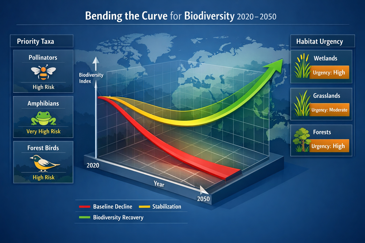
The "Bending the Curve" Concept
The phrase "bending the curve" refers to reversing biodiversity decline—shifting from a downward trajectory of species loss to an upward trend of recovery. Think of it as the inflection point where conservation efforts begin to outpace destruction.
Different scenarios produce different curves:
| Scenario Type | Trajectory | Key Characteristics |
|---|---|---|
| Baseline (BAU) | ⬇️ Continued decline | Business-as-usual policies; biodiversity continues falling |
| Stabilization | ➡️ Leveling off | Moderate interventions; decline slows but doesn't reverse |
| Recovery | ⬆️ Bending the curve | Transformative action; biodiversity begins recovering by 2030-2040 |
For surveyors, these scenarios provide a roadmap. They reveal which species groups are most vulnerable under baseline scenarios, which habitats require urgent intervention to achieve stabilization, and where monitoring efforts can best track progress toward recovery targets.
Why Scenarios Matter for Survey Planning
Traditional survey approaches often rely on historical baselines or opportunistic sampling. But in an era of accelerating biodiversity loss, historical patterns may no longer predict future needs. A species that was stable for decades might face sudden collapse due to emerging pressures.
Scenario-based planning shifts the focus from "what has always been monitored" to "what most urgently needs monitoring now." This approach aligns field ecology with policy frameworks like the COP27 biodiversity commitments and national conservation strategies.
Ecology Survey Strategy Under Accelerating Biodiversity Loss: Prioritising Taxa and Habitats
Using Scenarios to Identify At-Risk Taxa 🦋
Not all species face equal extinction risk. Scenario models consistently highlight certain taxonomic groups as particularly vulnerable:
High-Priority Taxa Under Most Scenarios:
- Pollinators (bees, butterflies, hoverflies) – Critical for ecosystem function and agriculture
- Amphibians – Sensitive to both climate change and habitat fragmentation
- Specialist species – Those with narrow habitat requirements or limited ranges
- Apex predators – Indicators of ecosystem health requiring large territories
- Endemic species – Found nowhere else, with no "backup" populations
When planning surveys, professionals should cross-reference regional scenario outputs with local species lists. For example, if scenarios predict severe grassland habitat loss in your region by 2035, grassland specialist butterflies and ground-nesting birds should receive heightened survey attention.
Habitat Prioritisation Through Scenario Analysis
Habitats face differential pressures under various scenarios. A strategic ecology survey strategy under accelerating biodiversity loss: using scenarios to prioritise what and where to monitor must account for:
Habitat Vulnerability Factors:
- Conversion risk – Likelihood of development or agricultural expansion
- Climate sensitivity – Vulnerability to temperature or precipitation changes
- Fragmentation status – Current connectivity and isolation
- Restoration potential – Feasibility of recovery interventions
- Policy protection – Existing or planned conservation designations
For instance, wetlands might show high vulnerability in baseline scenarios due to drainage and climate change, but high recovery potential in ambitious conservation scenarios. This makes them priority survey targets—monitoring can track whether real-world trends follow the negative or positive trajectory.
Creating a Taxa-Habitat Priority Matrix
Effective survey strategy combines taxa and habitat priorities into an integrated framework:
Priority Level 1 (Highest):
- Critically endangered taxa in highly threatened habitats
- Policy-indicator species in habitats targeted for restoration
- Endemic specialists in rapidly converting landscapes
Priority Level 2 (High):
- Vulnerable taxa in moderately threatened habitats
- Ecosystem service providers (pollinators, pest controllers)
- Species groups with poor baseline data
Priority Level 3 (Moderate):
- Stable taxa in threatened habitats (habitat quality indicators)
- Threatened taxa in protected habitats (monitoring effectiveness)
- Common species showing rapid decline trends
This matrix helps allocate survey effort proportionally. If budget constraints force choices, Level 1 priorities receive comprehensive annual monitoring, Level 2 gets biennial surveys, and Level 3 receives periodic assessments.
Regional Scenario Customisation
Global scenarios provide frameworks, but regional customisation is essential. A surveyor working in coastal England faces different pressures than one in upland Scotland. Effective strategy requires:
✅ Downscaling global scenarios to regional contexts
✅ Incorporating local pressure data (development plans, climate projections)
✅ Consulting regional biodiversity strategies and action plans
✅ Engaging local conservation organisations for on-the-ground insights
This localisation ensures survey priorities reflect actual conservation needs rather than generic global patterns. It also strengthens connections between field data and regional policy implementation, including frameworks like Biodiversity Net Gain assessments.
Pressure Indicators: What to Monitor Beyond Species Counts
Understanding Biodiversity Pressures
Scenarios model biodiversity futures by projecting how key pressures (threats) will intensify or diminish. The five main pressures recognized globally are:
- Habitat loss and degradation 🏗️
- Climate change 🌡️
- Pollution ☠️
- Invasive species 🦠
- Overexploitation 🎣
An ecology survey strategy under accelerating biodiversity loss: using scenarios to prioritise what and where to monitor must track not just species presence, but the pressures affecting them. This provides early warning signals and helps attribute observed changes to specific causes.

Selecting Pressure Indicators for Field Surveys
Rather than attempting to measure everything, scenario-informed surveys focus on pressure indicators—measurable variables that track the intensity of key threats:
Habitat Loss/Degradation Indicators:
- Habitat extent mapping (using GPS/GIS)
- Vegetation structure assessments
- Soil condition metrics
- Edge effect measurements
- Fragmentation indices
Climate Change Indicators:
- Phenology shifts (timing of flowering, migration)
- Range boundary changes
- Temperature-sensitive species presence
- Drought stress symptoms in vegetation
- Extreme weather impact documentation
Pollution Indicators:
- Lichen diversity (air quality)
- Aquatic invertebrate communities (water quality)
- Soil contamination bioassays
- Nutrient enrichment symptoms
Invasive Species Indicators:
- Non-native species presence and extent
- Native species displacement evidence
- Hybrid zone monitoring
- Pathway vulnerability assessments
Overexploitation Indicators:
- Population age structure
- Harvest pressure signs
- Disturbance frequency measures
Pressure-Priority Alignment
Different scenarios emphasize different pressures. Survey strategy should align with regional scenario outputs:
If scenarios show habitat loss as the dominant driver:
→ Prioritize habitat extent monitoring and condition assessments
→ Focus on development-threatened areas
→ Integrate with planning processes and biodiversity impact assessments
If scenarios emphasize climate change:
→ Establish phenology monitoring programs
→ Survey climate-sensitive species and edge-of-range populations
→ Monitor microclimate refugia
If scenarios highlight multiple interacting pressures:
→ Design multi-indicator surveys
→ Focus on synergy hotspots where pressures combine
→ Employ adaptive monitoring that can pivot as pressures shift
Indicator Selection Criteria
When budget constraints force choices among pressure indicators, apply these criteria:
Sensitivity – Does the indicator respond quickly to pressure changes?
Reliability – Can it be measured consistently across time and observers?
Cost-effectiveness – Does it provide good information per unit effort?
Policy-relevance – Do decision-makers use this information?
Baseline availability – Is there historical data for comparison?
The best indicators score highly across all criteria. For example, butterfly transects are sensitive to multiple pressures, have standardized protocols, require modest resources, inform conservation policy, and have decades of baseline data in many regions.
Implementing Scenario-Based Survey Strategy in Practice
Step 1: Access and Interpret Relevant Scenarios
Begin by identifying which scenarios apply to your region and taxonomic focus:
Global Scenario Sources:
- IPBES (Intergovernmental Science-Policy Platform on Biodiversity and Ecosystem Services) assessments
- IPCC (Intergovernmental Panel on Climate Change) biodiversity projections
- Academic publications modeling regional biodiversity futures
- National biodiversity strategies with scenario components
Interpretation Questions:
- What is the baseline trajectory for my region's priority habitats?
- Which taxa show the steepest decline under business-as-usual?
- What pressures dominate in different scenarios?
- At what timeline do "bending the curve" scenarios show recovery?
Many scenarios are complex, but focus on extracting actionable insights: Which components of biodiversity are most at risk? Which interventions show the greatest benefit?
Step 2: Map Scenarios to Survey Objectives
Connect scenario insights to concrete survey goals:
Conservation Monitoring:
→ Track whether real-world trends follow positive or negative scenario trajectories
→ Identify early warning signals of unexpected declines
→ Document success of interventions predicted to "bend the curve"
Policy Support:
→ Provide data for Biodiversity Net Gain requirements
→ Inform protected area effectiveness assessments
→ Support climate adaptation planning
→ Feed into sustainable farming incentive programs
Research and Adaptive Management:
→ Test scenario assumptions with empirical data
→ Identify model uncertainties requiring field validation
→ Inform scenario refinement for future iterations
Step 3: Design Integrated Survey Protocols
Translate priorities into field-ready protocols:
Stratified Sampling Design:
- Allocate effort proportionally to priority levels
- Ensure coverage across habitat types and pressure gradients
- Include reference sites (low-pressure areas) for comparison
- Incorporate spatial replication for statistical power
Temporal Planning:
- High-priority taxa/habitats: annual surveys
- Medium-priority: biennial or triennial cycles
- Low-priority: periodic (5-year) assessments
- Pressure indicators: frequency matched to rate of change
Method Selection:
- Standardized protocols for long-term comparability
- Cost-effective techniques for broad coverage
- Intensive methods for priority species/sites
- Technology integration (remote sensing, eDNA, acoustic monitoring) where appropriate
Step 4: Budget Allocation Framework
Limited resources require explicit prioritization:
Recommended Budget Distribution:
💰 50-60% → Priority Level 1 (highest-risk taxa/habitats)
💰 25-30% → Priority Level 2 (high-risk, policy-relevant)
💰 10-15% → Priority Level 3 (moderate-risk, baseline maintenance)
💰 5-10% → Emerging priorities and adaptive capacity
This framework ensures the bulk of resources target the most critical conservation needs while maintaining flexibility for unexpected developments.
Step 5: Integration with Existing Frameworks
Scenario-based survey strategy gains maximum impact when integrated with established conservation and planning frameworks:
Biodiversity Net Gain:
Survey data directly informs baseline assessments and monitoring of on-site and off-site delivery. Scenario insights help identify which habitats and species should receive greatest weight in achieving 10% net gain targets.
Protected Area Management:
Scenario-based priorities guide monitoring within reserves and inform management effectiveness assessments.
Development Planning:
Survey data supports biodiversity planning for developers and ensures compliance with environmental regulations.
Agricultural Schemes:
Monitoring aligns with agri-environment programs and tracks biodiversity responses to sustainable farming practices.
Step 6: Adaptive Management and Review
Scenarios are projections, not certainties. Regular review ensures strategy remains relevant:
Annual Review:
- Compare field results to scenario predictions
- Adjust priorities if unexpected trends emerge
- Incorporate new scenario publications
- Refine pressure indicator selection
Three-Year Strategic Review:
- Comprehensive reassessment of taxa/habitat priorities
- Budget reallocation based on accumulated evidence
- Protocol updates incorporating methodological advances
- Stakeholder consultation on policy needs
Scenario Update Cycles:
- Major scenario publications (typically 5-10 year cycles) trigger strategic overhauls
- Interim updates adjust for new pressures or policy changes
- Climate scenario updates inform temperature-sensitive priorities
Overcoming Common Implementation Challenges
Challenge 1: Scenario Complexity and Accessibility 📊
Problem: Scenario publications are often technical and difficult to interpret for practical survey planning.
Solutions:
- Seek scenario summaries and policy briefs rather than full technical reports
- Collaborate with academic institutions that produce scenarios
- Attend workshops and webinars on scenario interpretation
- Use simplified scenario frameworks (e.g., "low," "medium," "high" intervention scenarios)
- Consult conservation organizations that translate scenarios into action plans
Challenge 2: Data Gaps and Baseline Deficiencies
Problem: Scenarios may highlight priority taxa or habitats for which little baseline data exists.
Solutions:
- Allocate "discovery budget" to establish new baselines for data-poor priorities
- Use rapid assessment methods initially, transitioning to detailed monitoring
- Leverage citizen science and volunteer networks for broad coverage
- Employ technology (eDNA, remote sensing) to efficiently fill gaps
- Accept uncertainty and use precautionary prioritization for poorly-known groups
Challenge 3: Conflicting Priorities
Problem: Different scenarios, stakeholders, or policy frameworks may suggest conflicting survey priorities.
Solutions:
- Develop multi-criteria decision frameworks weighing different objectives
- Engage stakeholders early to build consensus on priority rankings
- Design flexible protocols that serve multiple purposes
- Communicate trade-offs transparently
- Pilot approaches in limited areas before full implementation
Challenge 4: Budget Constraints
Problem: Even prioritized surveys may exceed available resources.
Solutions:
- Phase implementation over multiple years
- Seek partnerships to share costs (universities, NGOs, government agencies)
- Leverage technology to reduce per-unit survey costs
- Focus on "keystone" indicators that inform multiple priorities
- Be explicit about what cannot be monitored and document the gap
Challenge 5: Maintaining Long-Term Commitment
Problem: Scenario-based monitoring requires sustained effort over decades, but funding and institutional priorities shift.
Solutions:
- Embed monitoring in regulatory frameworks (e.g., Biodiversity Net Gain requirements)
- Demonstrate policy impact through regular reporting to decision-makers
- Build diverse funding portfolios rather than relying on single sources
- Create data sharing agreements that increase value to multiple users
- Invest in volunteer and community monitoring for resilience
Case Study: Applying Scenario-Based Prioritisation
Context
A regional biodiversity surveying organization in southern England manages surveys across 500 square kilometers of mixed agricultural, woodland, and wetland habitats. With a modest annual budget, they must prioritize among competing monitoring needs.
Scenario Analysis
Reviewing national and regional biodiversity scenarios, the team identifies:
- Baseline scenario shows 40% decline in pollinator diversity by 2040 due to agricultural intensification and habitat loss
- Grassland habitats face highest conversion pressure (30% loss projected)
- Climate scenarios predict northward range shifts for temperature-sensitive species
- Wetland restoration features prominently in positive "bending the curve" scenarios
Priority Setting
Based on scenario insights, the organization establishes:
Priority Level 1:
- Pollinator surveys (bees, butterflies, hoverflies) in grassland habitats
- Grassland condition assessments in development-threatened areas
- Wetland restoration site monitoring
Priority Level 2:
- Woodland bird surveys (climate-sensitive species)
- Aquatic invertebrate monitoring (water quality indicators)
- Invasive species tracking in vulnerable habitats
Priority Level 3:
- General biodiversity baseline maintenance
- Opportunistic records of rare species
- Public engagement and citizen science coordination
Implementation
Budget allocation:
- 55% to Priority 1 (pollinator and grassland focus)
- 30% to Priority 2 (complementary monitoring)
- 15% to Priority 3 and adaptive capacity
Methods:
- Standardized transect surveys for pollinators (monthly, April-September)
- Grassland condition assessments using national frameworks
- Wetland monitoring aligned with restoration project timelines
- Technology integration (acoustic monitoring for birds, remote sensing for habitat extent)
Outcomes
After three years:
- Documented 25% decline in grassland specialist butterflies, confirming scenario predictions
- Identified specific pressure hotspots (intensive agriculture zones)
- Provided data supporting Biodiversity Net Gain planning for three major developments
- Informed regional conservation strategy revisions
- Secured additional funding based on demonstrated policy impact
This case demonstrates how ecology survey strategy under accelerating biodiversity loss: using scenarios to prioritise what and where to monitor translates from concept to measurable conservation outcomes.
The Future of Scenario-Based Ecological Surveying
Emerging Trends for 2026 and Beyond 🚀
Technology Integration:
Advances in remote sensing, artificial intelligence, and environmental DNA are making scenario-based monitoring more feasible. Surveyors can now:
- Use satellite imagery to track habitat change at landscape scales
- Employ AI-powered species identification for rapid assessments
- Detect species presence through eDNA without extensive field searches
- Integrate real-time data streams for adaptive priority adjustment
Improved Scenario Resolution:
Next-generation biodiversity scenarios offer:
- Higher spatial resolution (regional and local scales)
- Better integration of multiple pressures and their interactions
- Incorporation of socioeconomic pathways and policy options
- Probabilistic projections rather than single-trajectory models
Policy Integration:
Growing recognition of biodiversity's importance is strengthening links between monitoring and policy:
- Mandatory biodiversity reporting requirements
- Biodiversity Net Gain frameworks creating sustained monitoring demand
- International agreements requiring evidence-based progress tracking
- Financial sector engagement with nature-related risks
Building Capacity for Scenario-Based Approaches
Organizations and individual surveyors can prepare by:
Professional Development:
- Training in scenario interpretation and application
- GIS and spatial analysis skills
- Statistical methods for trend detection
- Communication skills for translating data to policy
Organizational Infrastructure:
- Database systems for long-term data management
- Partnerships with research institutions
- Stakeholder engagement frameworks
- Quality assurance protocols
Community Building:
- Participation in monitoring networks
- Data sharing and standardization initiatives
- Collaboration across sectors (conservation, planning, agriculture)
- Public engagement and citizen science programs
Conclusion
The accelerating loss of biodiversity demands strategic, evidence-based approaches to ecological surveying. Ecology survey strategy under accelerating biodiversity loss: using scenarios to prioritise what and where to monitor provides a framework for making difficult decisions about resource allocation in an era of limited budgets and unlimited conservation needs.
By grounding survey priorities in scientifically robust scenarios, professionals can focus their efforts on the taxa, habitats, and pressure indicators that matter most for conservation outcomes. This approach ensures field data directly informs the policies and interventions needed to "bend the curve" from biodiversity decline to recovery.
Actionable Next Steps
For biodiversity surveyors and conservation professionals ready to implement scenario-based strategies:
-
Review relevant scenarios for your region and taxonomic focus—start with national biodiversity strategies and IPBES assessments
-
Conduct a priority assessment using the taxa-habitat matrix framework outlined in this article
-
Redesign survey protocols to align effort with priority levels and pressure indicators
-
Integrate with policy frameworks like Biodiversity Net Gain to maximize data impact
-
Establish partnerships with research institutions, conservation organizations, and government agencies
-
Invest in capacity building through training, technology, and data management infrastructure
-
Implement adaptive management with regular reviews and adjustments based on emerging evidence
The challenge of biodiversity loss is immense, but strategic, scenario-informed surveying ensures every field hour contributes to the larger goal of nature recovery. In 2026 and beyond, the question is not whether we can afford to prioritize—it's whether we can afford not to.
For organizations seeking expert guidance on implementing scenario-based survey strategies or integrating monitoring with Biodiversity Net Gain requirements, professional support can accelerate the transition from traditional approaches to strategic, future-focused ecological surveying.
