
Recent regulatory changes have accelerated deep-sea mining operations at an alarming rate. NOAA's January 2026 rule cut environmental assessment timelines in half, while The Metals Company immediately doubled its extraction request to cover 65,000 square kilometers of the Pacific seabed[1]. For surveyors monitoring coastal Biodiversity Net Gain (BNG) sites, this expansion presents an unprecedented challenge: how do you detect and document ecosystem spillover from mining operations occurring thousands of meters below the surface, potentially hundreds of kilometers away?
Understanding Deep-Sea Mining Threats to Coastal BNG Sites: Surveyor Protocols for Monitoring Seabed Ecosystem Spillover has become essential for environmental professionals tasked with protecting nearshore habitats. The extraction methods—essentially vacuuming the top four inches of seafloor—create sediment plumes that spread throughout the water column, threatening both abyssal ecosystems and commercially important coastal fisheries[1]. With 80% of the seabed remaining unmapped, establishing baseline data before irreversible damage occurs represents a critical window of opportunity closing rapidly.
Key Takeaways
- 🌊 Sediment plumes from deep-sea mining operations can travel through the water column, affecting coastal BNG sites hundreds of kilometers from extraction zones
- 📊 Integrated survey frameworks combining ROV deployment, sediment analysis, and acoustic monitoring provide essential baseline data before mining impacts occur
- ⚠️ Recovery timelines for damaged seafloor ecosystems span decades or may never occur, making pre-emptive monitoring protocols critically important
- 🔬 Surveyors must establish multi-depth sampling stations to track ecosystem spillover from abyssal plains to coastal protection zones
- 📈 Current regulatory changes have halved environmental assessment periods, requiring accelerated baseline documentation for coastal BNG sites
Understanding the Scope of Deep-Sea Mining Threats to Coastal BNG Sites
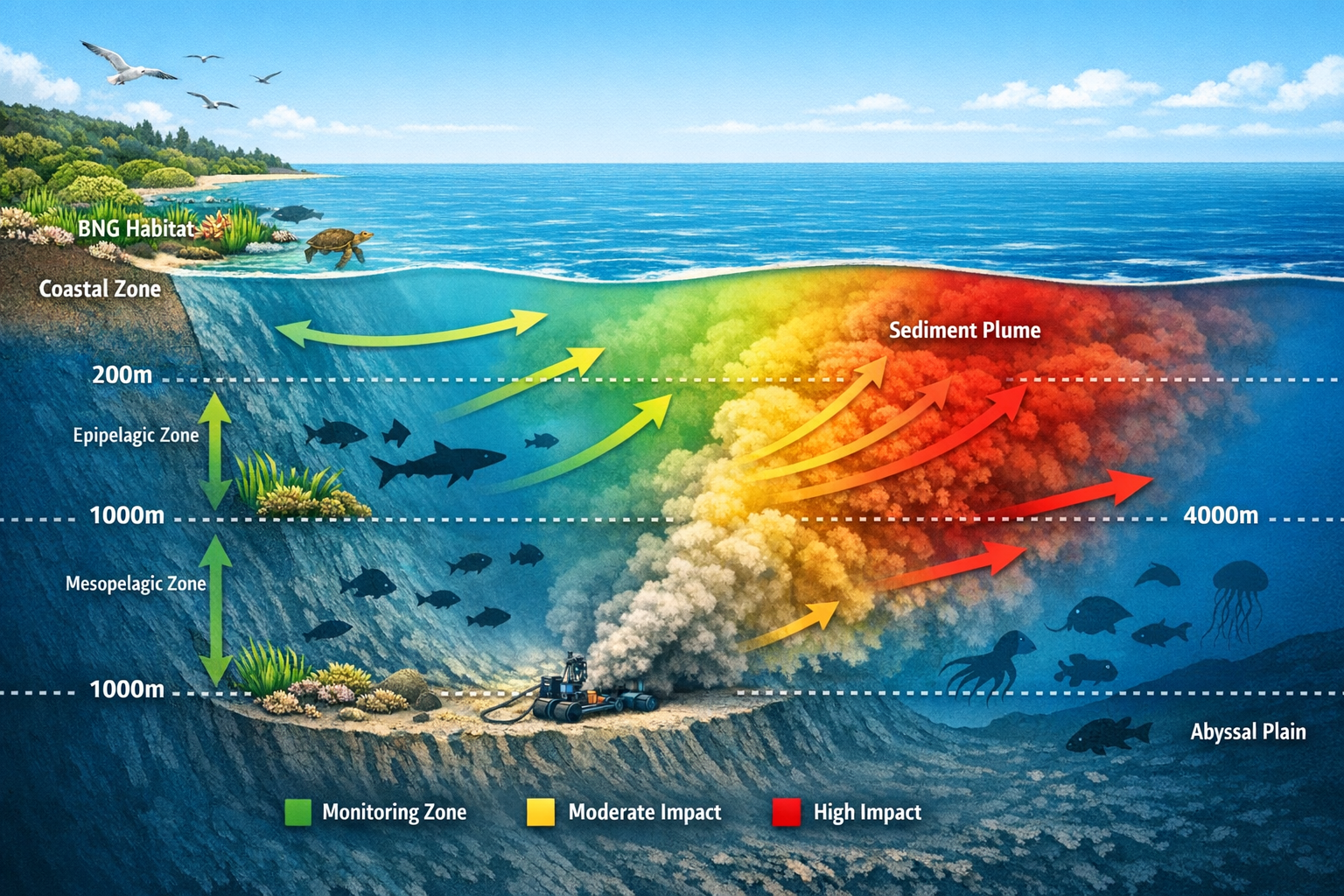
The scale of proposed deep-sea mining operations extends far beyond initial extraction zones. The Clarion-Clipperton Zone in the Pacific Ocean—a primary target for polymetallic nodule extraction—supports thousands of species, many unknown to science[1]. When mining equipment disturbs the seafloor at depths of 4,000-6,000 meters, the resulting sediment plumes don't remain confined to the abyssal plain.
Physical Mechanisms of Ecosystem Spillover
Sediment plumes created during extraction rise through the water column due to turbulence and ocean currents. These plumes carry:
- Fine particulate matter that can travel hundreds of kilometers
- Crushed benthic organisms and organic material
- Disturbed chemical compounds from seafloor sediments
- Microplastics and contaminants concentrated in deep-sea environments
Research indicates that sediment dispersal patterns follow prevailing deep-ocean currents, which eventually connect to upwelling zones near coastal regions[5]. For surveyors monitoring coastal BNG sites, this means potential impacts may manifest far from the mining location itself.
Regulatory Landscape Changes in 2026
The Trump administration's April 2025 executive order permitting deep-sea mining in international waters created legal conflicts with the United Nations Convention on the Law of the Sea[2]. This regulatory shift has significant implications:
| Regulatory Change | Impact on Coastal Monitoring | Surveyor Response Required |
|---|---|---|
| Halved assessment periods | Compressed baseline data collection timelines | Accelerated survey deployment |
| Reduced public comment windows | Limited stakeholder input on coastal impacts | Enhanced independent monitoring |
| Streamlined permitting | More simultaneous operations | Expanded geographic coverage |
| International waters access | Reduced oversight of spillover effects | Cross-boundary tracking protocols |
Despite these regulatory rollbacks, 40 countries have called for a moratorium or precautionary pause on deep-sea mining, including major economies like France, Germany, and the UK[1]. Papua New Guinea instituted a 10-year moratorium in 2026, responding to local resistance and scientific concerns[5].
Connecting Deep-Sea Operations to Coastal BNG Obligations
For developers and landowners managing biodiversity net gain obligations, understanding deep-sea mining threats requires recognizing the interconnected nature of marine ecosystems. Coastal BNG sites—whether established through off-site delivery mechanisms or habitat banking arrangements—face potential degradation from:
- Water quality deterioration due to increased turbidity
- Trophic cascade disruptions affecting commercially important species
- Habitat suitability changes in benthic coastal environments
- Bioaccumulation pathways introducing contaminants into food webs
The critical knowledge gap—80% of the seabed remains unmapped—means surveyors cannot rely on existing baseline data[1]. This necessitates proactive establishment of monitoring protocols before mining operations commence.
Surveyor Protocols for Monitoring Seabed Ecosystem Spillover: Technical Frameworks
Developing robust monitoring protocols for Deep-Sea Mining Threats to Coastal BNG Sites requires integrated approaches combining multiple survey methodologies. The following frameworks provide surveyors with actionable strategies for detecting ecosystem spillover before irreversible damage occurs.
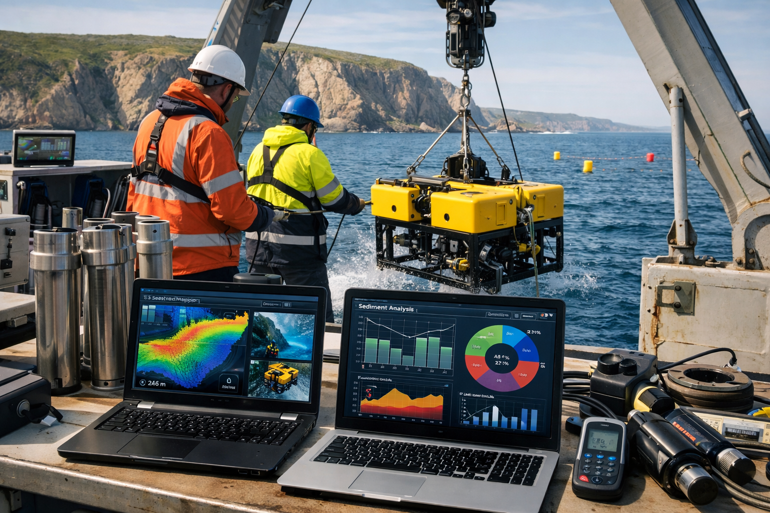
ROV-Based Seabed Assessment Protocols
Remotely Operated Vehicles (ROVs) represent the primary tool for direct seabed observation at depths where diving is impossible. Survey protocols should include:
Pre-Mining Baseline Documentation:
- High-resolution video transects across multiple depth zones (200m, 500m, 1000m, 2000m+)
- Photographic quadrat sampling for benthic species identification
- Substrate composition mapping using ROV-mounted sensors
- 3D bathymetric modeling to establish topographic baselines
Operational Monitoring During Mining Activities:
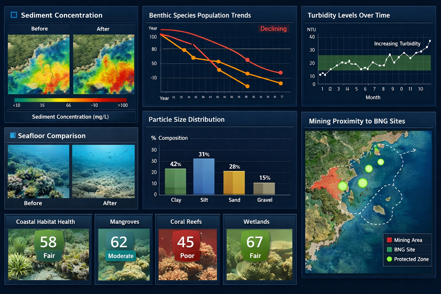
- Real-time turbidity measurements at varying distances from extraction sites
- Sediment plume tracking using acoustic backscatter technology
- Benthic community composition changes documented through repeat transects
- Particle size distribution analysis in water column samples
Post-Impact Assessment:
- Recovery trajectory documentation at 6-month intervals
- Comparative analysis against pre-mining baseline conditions
- Species recolonization patterns and timelines
- Substrate stability and erosion monitoring
Sediment Analysis and Tracking Protocols
Understanding sediment movement from deep-sea mining sites to coastal BNG zones requires comprehensive sediment characterization:
🔬 Laboratory Analysis Components:
- Grain size distribution to identify mining-derived particles
- Geochemical fingerprinting to trace sediment origins
- Heavy metal concentration testing for contamination assessment
- Organic content analysis to detect crushed biological material
Field Sampling Strategy:
- Establish sampling stations along predicted current pathways
- Deploy sediment traps at multiple depths (surface, mid-column, near-bottom)
- Collect samples at increasing distances from mining operations (10km, 50km, 100km, 200km)
- Maintain monthly sampling frequency during active mining periods
Acoustic Monitoring and Water Column Assessment
Acoustic Doppler Current Profilers (ADCPs) provide continuous data on current patterns and suspended sediment concentrations. Survey protocols should incorporate:
- Current velocity mapping to predict sediment transport pathways
- Backscatter intensity measurements indicating suspended particle concentrations
- Multi-frequency acoustic systems to distinguish particle sizes
- Long-term deployment strategies capturing seasonal variation
Biological Indicator Species Monitoring
Certain species serve as sensitive indicators of ecosystem spillover effects. Surveyors should establish monitoring programs for:
Filter-feeding organisms (mussels, oysters, barnacles):
- Tissue analysis for accumulated particulates and contaminants
- Growth rate measurements indicating stress responses
- Population density changes in coastal BNG sites
- Reproductive success monitoring
Commercially important fish species:
- Larval abundance and survival rates
- Migration pattern alterations
- Feeding behavior changes
- Catch data correlation with mining activities
Benthic invertebrates:
- Community composition shifts
- Abundance and diversity indices
- Sensitive species presence/absence
- Functional group changes
Establishing Multi-Depth Sampling Stations
A comprehensive monitoring network requires stratified sampling across depth zones:
| Depth Zone | Primary Threats | Monitoring Focus | Sampling Frequency |
|---|---|---|---|
| 0-50m (Coastal BNG sites) | Settled sediment, water quality | Benthic communities, turbidity | Weekly during mining |
| 50-200m (Shelf) | Suspended sediment, trophic impacts | Fish larvae, plankton, water chemistry | Bi-weekly |
| 200-1000m (Slope) | Intermediate plume dispersal | Current patterns, sediment flux | Monthly |
| 1000m+ (Deep) | Direct mining impacts | Baseline conditions, plume generation | Quarterly |
Data Integration and Reporting Frameworks
Effective monitoring requires synthesizing multiple data streams into actionable intelligence. Surveyors should implement:
- Geographic Information Systems (GIS) for spatial analysis and visualization
- Time-series databases tracking changes across monitoring parameters
- Statistical analysis protocols detecting significant deviations from baseline
- Automated alert systems triggering rapid response when thresholds are exceeded
- Standardized reporting templates ensuring consistency across survey teams
For organizations conducting biodiversity impact assessments, integrating deep-sea mining threat analysis into existing frameworks ensures comprehensive risk evaluation.
Implementing Pre-Emptive Baseline Protocols for Coastal BNG Protection
The compressed timelines created by 2026 regulatory changes demand immediate action from surveyors responsible for coastal BNG site protection. Establishing comprehensive baseline data before mining operations commence represents the only opportunity to document pre-impact conditions.
Rapid Baseline Assessment Methodology
When time constraints prevent multi-year baseline studies, surveyors can implement accelerated assessment protocols:
Phase 1: Desktop Analysis (2-4 weeks)
- Review existing oceanographic data and current patterns
- Identify potential mining sites and predicted impact zones
- Map coastal BNG sites within potential spillover range
- Prioritize high-risk locations for field assessment
Phase 2: Intensive Field Campaign (6-8 weeks)
- Deploy multiple survey teams simultaneously across depth zones
- Conduct concentrated ROV surveys capturing maximum spatial coverage
- Establish permanent monitoring stations with automated sensors
- Collect comprehensive sediment and biological samples
Phase 3: Laboratory Analysis and Baseline Documentation (4-6 weeks)
- Process samples using standardized protocols
- Create baseline reference database for future comparison
- Develop predictive models for sediment dispersal
- Establish threshold values triggering management responses
Collaborative Monitoring Networks
Individual organizations rarely possess resources for comprehensive ocean-scale monitoring. Collaborative frameworks enhance coverage and data quality:
- Multi-stakeholder partnerships combining government agencies, research institutions, and private surveyors
- Shared equipment pools reducing capital costs for specialized ROV and acoustic systems
- Standardized protocols ensuring data compatibility across organizations
- Centralized data repositories facilitating meta-analysis and pattern detection
Technology Integration for Enhanced Detection
Emerging technologies provide surveyors with enhanced capabilities for detecting subtle ecosystem changes:
Autonomous Underwater Vehicles (AUVs):
- Extended survey duration without surface vessel support
- Standardized transect patterns ensuring consistent coverage
- Multi-sensor integration capturing physical, chemical, and biological data
- Cost-effective monitoring for remote coastal BNG sites
Environmental DNA (eDNA) Analysis:
- Non-invasive species detection from water samples
- Sensitive indicator of community composition changes
- Rapid processing timelines supporting adaptive management
- Baseline biodiversity cataloging before mining impacts
Satellite Remote Sensing:
- Surface water quality monitoring across vast areas
- Detection of large-scale sediment plumes reaching surface waters
- Temporal analysis tracking seasonal patterns
- Cost-effective complement to in-situ monitoring
Adaptive Management Triggers and Response Protocols
Monitoring data only provides value when linked to management actions. Surveyors should establish clear threshold-based response frameworks:
Tier 1 Alert (Minor Deviation):
- 10-20% increase in turbidity above baseline
- Increased sampling frequency
- Enhanced communication with mining operators
- No immediate intervention required
Tier 2 Alert (Moderate Impact):
- 20-40% increase in turbidity or detectable sediment accumulation
- Deployment of additional monitoring equipment
- Formal notification to regulatory authorities
- Initiation of impact investigation protocols
Tier 3 Alert (Severe Impact):
-
40% increase in turbidity or measurable biological impacts
- Immediate cessation request for mining operations
- Emergency response team deployment
- Comprehensive damage assessment and remediation planning
For developers managing BNG obligations, understanding these monitoring frameworks helps ensure coastal offset sites remain viable long-term.
Financial Considerations and Resource Allocation
Comprehensive seabed monitoring requires significant investment. Surveyors should consider:
Equipment Costs:
- ROV systems: £50,000-£500,000 depending on depth rating and capabilities
- Acoustic monitoring equipment: £20,000-£100,000 per station
- Laboratory analysis: £500-£2,000 per sample set
- Data management systems: £10,000-£50,000 for integrated platforms
Operational Costs:
- Vessel charter: £5,000-£15,000 per day for research-capable ships
- Personnel: Specialized marine surveyors command £400-£800 per day
- Sample processing: £200-£500 per sample for comprehensive analysis
- Long-term monitoring: £50,000-£200,000 annually for sustained programs
Organizations can reduce costs through:
- Collaborative partnerships sharing vessel and equipment expenses
- Phased implementation prioritizing highest-risk areas initially
- Technology leverage using AUVs and automated systems reducing vessel time
- Grant funding from conservation organizations and research institutions
Legal and Regulatory Compliance
Surveyors must navigate complex jurisdictional frameworks when monitoring Deep-Sea Mining Threats to Coastal BNG Sites:
- Territorial waters (0-12 nautical miles): National jurisdiction applies
- Exclusive Economic Zones (12-200 nautical miles): Coastal state resource rights
- International waters (beyond 200 nautical miles): International Seabed Authority governance
- Cross-boundary impacts: Requiring international cooperation and data sharing
Understanding these boundaries ensures monitoring programs maintain legal compliance while capturing ecosystem spillover across jurisdictional lines.
Integration with Existing BNG Frameworks
Coastal BNG sites established under UK biodiversity net gain requirements must account for external threats beyond traditional land-use pressures. Surveyors should:
- Include deep-sea mining risk assessments in biodiversity impact assessments
- Establish monitoring protocols as part of long-term management plans
- Document baseline conditions for off-site BNG delivery
- Consider alternative site selection when mining threats are significant
- Incorporate adaptive management provisions in legal agreements
For landowners considering selling biodiversity units from coastal properties, demonstrating robust monitoring protocols enhances site credibility and long-term value.
Conclusion
Deep-Sea Mining Threats to Coastal BNG Sites represent an emerging challenge requiring immediate surveyor attention. The regulatory landscape of 2026—characterized by streamlined permitting and halved assessment periods—has accelerated mining operations while simultaneously compressing the window for establishing critical baseline data[1][2]. Recovery timelines for damaged seafloor ecosystems span decades or may never occur, making pre-emptive monitoring protocols essential rather than optional[1].
Surveyors must implement integrated frameworks combining ROV deployment, sediment analysis, acoustic monitoring, and biological indicator tracking to detect ecosystem spillover before irreversible damage occurs. The 80% of unmapped seabed represents both a knowledge gap and an opportunity: organizations establishing comprehensive baseline documentation now position themselves as essential partners in marine ecosystem protection[1].
Actionable Next Steps for Surveyors
✅ Immediate Actions (Next 30 Days):
- Conduct desktop analysis identifying coastal BNG sites within potential mining impact zones
- Review existing oceanographic data and current patterns for your region
- Establish partnerships with research institutions and collaborative monitoring networks
- Secure funding for baseline assessment programs
✅ Short-Term Implementation (3-6 Months):
- Deploy rapid baseline assessment protocols at priority coastal BNG sites
- Establish permanent monitoring stations with automated sensors
- Collect comprehensive sediment and biological samples for reference databases
- Develop threshold-based response frameworks linking monitoring to management actions
✅ Long-Term Strategy (6-12 Months):
- Implement sustained monitoring programs with quarterly assessments
- Integrate deep-sea mining risk analysis into biodiversity net gain assessments
- Contribute data to regional and international monitoring networks
- Advocate for enhanced regulatory protections based on monitoring findings
The expansion of deep-sea mining operations presents unprecedented challenges for coastal ecosystem protection. However, surveyors equipped with robust monitoring protocols and integrated assessment frameworks can provide the early warning systems necessary to protect valuable BNG sites from seabed ecosystem spillover. The time to act is now—before the sediment plumes reach our shores.
For professional guidance on implementing comprehensive monitoring protocols for your coastal BNG sites, contact experienced biodiversity surveyors who understand the complex interactions between deep-sea operations and nearshore ecosystem health.
References
[1] Threats Of Permitting Deep Sea Mining – https://oceanfdn.org/threats-of-permitting-deep-sea-mining/
[2] Mining Without Rules The Risky Us Bet On The Deep Sea – https://www.atlanticcouncil.org/in-depth-research-reports/issue-brief/mining-without-rules-the-risky-us-bet-on-the-deep-sea/
[5] Deep Sea Wildernesses Are More Important Than The Promise Of Seafloor Mining Analysis – https://news.mongabay.com/2026/04/deep-sea-wildernesses-are-more-important-than-the-promise-of-seafloor-mining-analysis/
