
The world stands at a critical juncture. Despite decades of conservation efforts, biodiversity continues to decline at alarming rates. Yet emerging scenario analyses reveal a transformative possibility: bending the biodiversity curve upward by mid-century through unprecedented cross-sector coordination. As we navigate the post-2026 landscape following the Kunming-Montreal Global Biodiversity Framework (KMGBF), biodiversity surveyors and practitioners face an urgent mandate to implement integrated protocols that span conservation, agriculture, food systems, and waste management.
This comprehensive guide explores Bending the Biodiversity Curve: Integrated Cross-Sector Survey Protocols Post-2026 Scenario Reviews, synthesizing recent global scenario analyses to equip professionals with actionable, multi-sector approaches for halting and reversing biodiversity loss.
Key Takeaways
- 🌍 Bending-the-curve scenarios project an average positive change of 3.6% in biodiversity indicators by 2050, compared to baseline projections showing a 5.9% decline—but these scenarios remain exceptionally rare with fewer than 15 comprehensive studies identified[1][2]
- 🍽️ Diet change, reduced food waste, and sustainable agricultural intensification are mandatory interventions appearing across all successful biodiversity scenarios, representing the only universally adopted policy measures[2]
- 📊 Current scenarios inadequately address multiple biodiversity drivers, with most focusing solely on land-use change while overlooking climate change, pollution, and invasive species—risking significant underestimation of reversal difficulty[2]
- 🎯 Standardized cross-sector survey protocols and comparable indicators are critically needed to enable policy-makers and practitioners to evaluate biodiversity scenarios across different studies and regions[2]
- ⏰ Reversing terrestrial biodiversity trends requires coordinated action by mid-century (2042–2061 confidence interval), with two-thirds of future losses potentially avoidable through integrated strategies[6]
Understanding Bending the Biodiversity Curve: The Post-2026 Context
What Does "Bending the Curve" Actually Mean?
Bending the biodiversity curve refers to reversing current negative biodiversity trends and achieving net positive outcomes by mid-century. Rather than continuing the downward trajectory of species loss and habitat degradation, this concept envisions interventions powerful enough to create an upward trend in biodiversity indicators.
The term gained prominence following the KMGBF adoption, which established international commitments to halt and reverse biodiversity loss by 2030. However, research reveals a sobering reality: current policies still project continued decline despite these ambitious targets[1].
The Rarity of Successful Scenarios
One of the most striking findings from recent scenario reviews is how exceptionally rare bending-the-curve scenarios actually are. Comprehensive analyses have identified fewer than 15 studies that successfully model positive biodiversity outcomes[1][2]. This scarcity highlights both the difficulty of reversing biodiversity loss and the urgent need for more robust scenario planning.
These rare successful scenarios share common characteristics:
- Integrated interventions across multiple sectors simultaneously
- Transformative changes in food production and consumption
- Expanded conservation areas beyond current protected area networks
- Reduced pressure from unsustainable resource extraction
- Long-term commitment spanning decades, not years
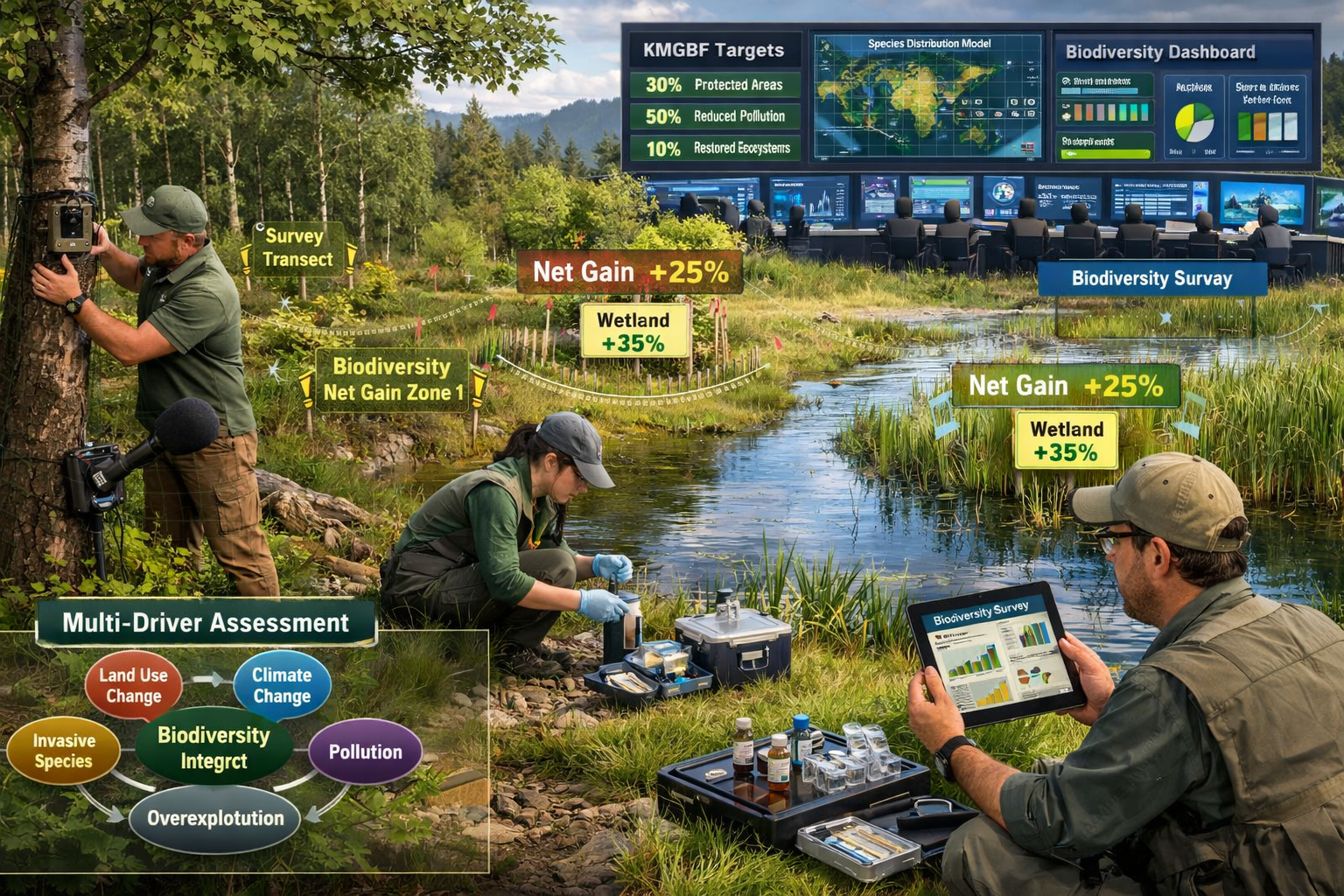
The KMGBF Framework and Survey Implications
The Kunming-Montreal Global Biodiversity Framework establishes critical targets for 2030 and 2050, creating new demands for biodiversity surveyors and practitioners. Understanding how to conduct biodiversity impact assessments within this framework requires integrating global scenario insights with local monitoring protocols.
Key KMGBF targets directly affecting survey protocols include:
- 30×30 goal: Protecting 30% of terrestrial and marine areas by 2030
- Restoration commitments: Restoring 30% of degraded ecosystems
- Biodiversity net gain requirements: Ensuring development delivers positive outcomes
- Mainstreaming biodiversity: Integrating considerations across all economic sectors
Core Components of Integrated Cross-Sector Survey Protocols
Mandatory Policy Interventions Across All Scenarios
Research conclusively demonstrates that three interventions appear in every single successful bending-the-curve scenario[2]:
- Diet transformation toward plant-based consumption
- Food waste reduction across production and consumption chains
- Sustainable agricultural intensification without habitat conversion
For biodiversity surveyors, this universal pattern demands protocol adjustments that account for agricultural landscapes, food system impacts, and dietary shift indicators alongside traditional conservation metrics.
Practical Survey Integration
When developing biodiversity plans for development projects, practitioners must now incorporate:
- Agricultural impact assessments evaluating farming intensity and sustainability practices
- Food system connectivity measuring how developments affect local food production and waste
- Diet-related habitat pressure quantifying land-use demands from different consumption patterns
- Waste infrastructure biodiversity impacts assessing how waste reduction facilities affect local ecosystems
Addressing Multiple Drivers: The Critical Gap
One of the most significant findings from scenario reviews is that nearly all bending-the-curve scenarios fail to account for multiple drivers of biodiversity loss[2]. Most models address land-use change while overlooking:
- 🌡️ Climate change impacts on species distribution and ecosystem function
- 💧 Pollution from agricultural runoff, plastics, and chemicals
- 🦠 Invasive species introduction and spread
- 🎣 Overexploitation of wild species and resources
- 🏙️ Habitat fragmentation from infrastructure development
This limitation creates substantial risk: scenarios may dramatically underestimate the difficulty of reversing biodiversity decline by ignoring compounding pressures.
Survey Protocol Recommendation: Develop multi-driver assessment frameworks that simultaneously evaluate land-use, climate vulnerability, pollution exposure, invasive species presence, and exploitation pressure within survey areas.
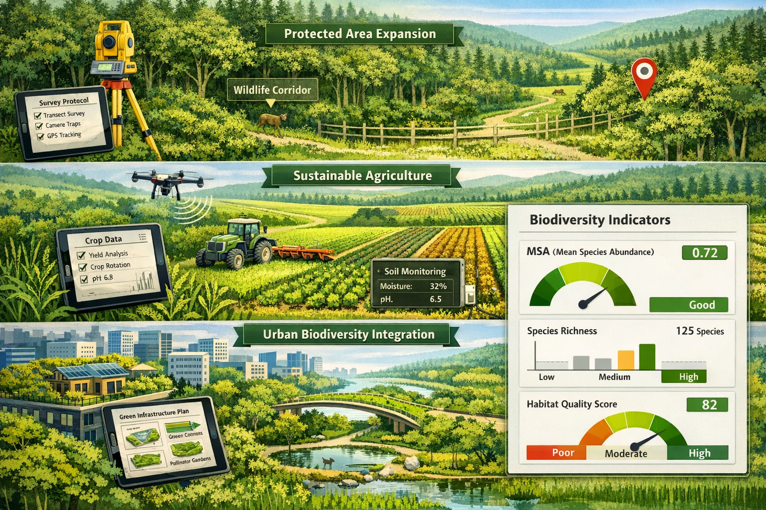
Standardized Indicators for Cross-Sector Comparison
The lack of standardized indicators across biodiversity scenarios severely hampers policy-maker ability to compare studies and make informed decisions[2]. For surveyors implementing biodiversity net gain assessments, establishing comparable metrics becomes essential.
Recommended Standardized Indicators
| Indicator Category | Specific Metrics | Survey Application |
|---|---|---|
| Species Abundance | Mean Species Abundance (MSA), Species Richness | Baseline and monitoring surveys across habitats |
| Habitat Quality | Habitat Integrity Index, Connectivity Scores | Site condition assessments, corridor mapping |
| Ecosystem Function | Pollination Services, Carbon Sequestration | Functional diversity surveys, ecosystem service valuation |
| Pressure Indicators | Land-Use Intensity, Climate Exposure Index | Multi-driver threat assessments |
| Policy Compliance | Protected Area Coverage, Net Gain Achievement | Regulatory compliance monitoring |
These standardized indicators enable meaningful comparison across projects, regions, and timeframes—essential for tracking progress toward biodiversity net gain targets.
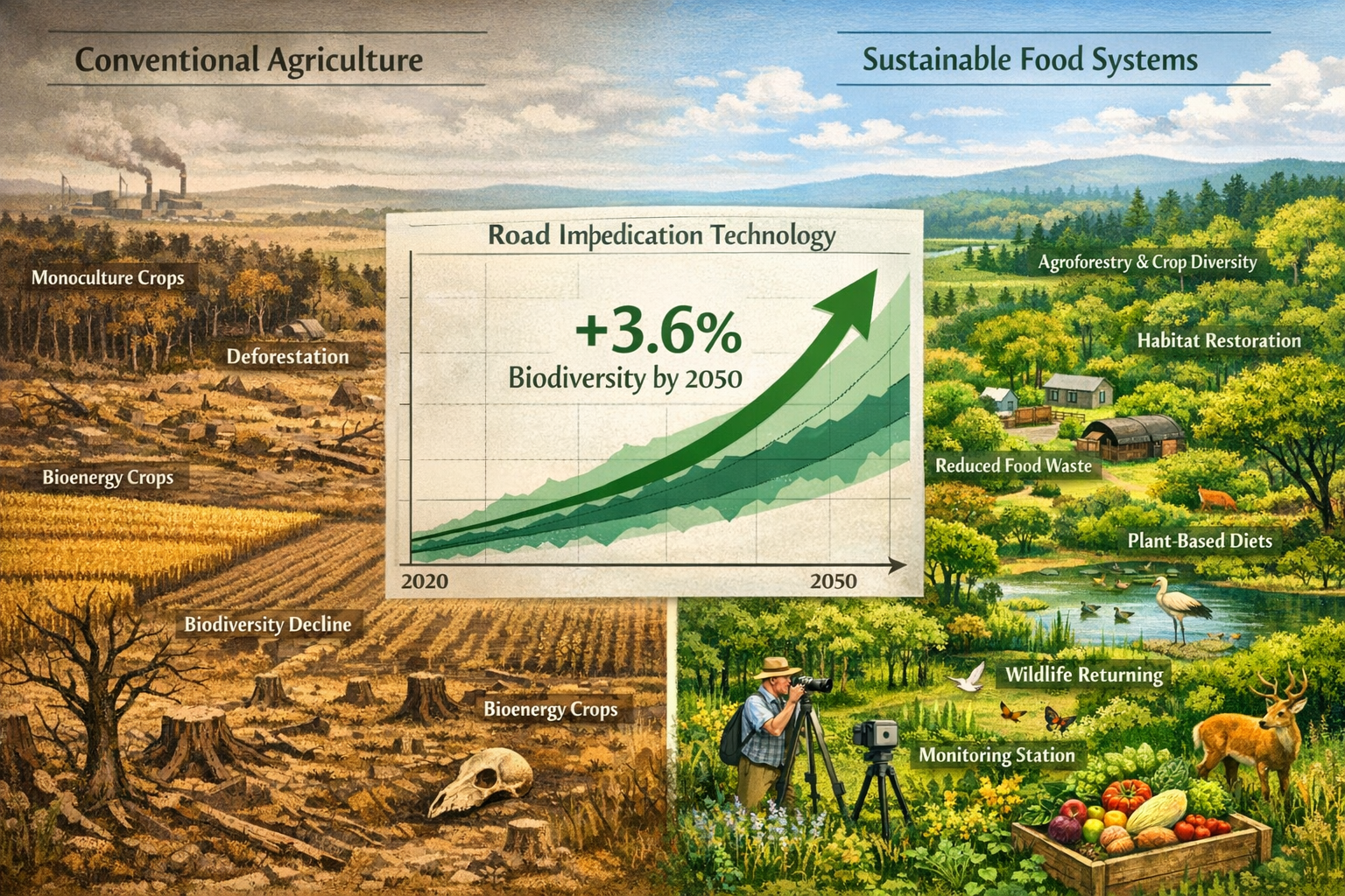
Bending the Biodiversity Curve Through Food System Transformation
The Universal Role of Diet Change
Every successful bending-the-curve scenario includes significant dietary transformation[2][6]. Research indicates that two-thirds of future biodiversity losses could be avoided through sustainable intensification, reduced trade barriers, food waste reduction, and plant-based diet adoption by 2050[6].
For biodiversity surveyors, this creates new assessment responsibilities:
Agricultural Landscape Surveys must evaluate:
- Current production intensity and biodiversity impacts
- Potential for sustainable intensification without habitat conversion
- Crop diversity and pollinator support
- Soil health and carbon storage capacity
Development Impact Assessments should incorporate:
- Food production displacement effects
- Local food system connectivity
- Waste management infrastructure biodiversity impacts
- Dietary shift facilitation through urban design
Sustainable Intensification Without Expansion
Sustainable intensification—increasing agricultural productivity on existing farmland without converting natural habitats—appears consistently in successful scenarios[2][6]. However, implementing this requires careful monitoring to ensure intensification genuinely remains sustainable.
Survey protocols should assess:
✅ Yield improvements through precision agriculture and technology
✅ Biodiversity maintenance within agricultural matrices
✅ Reduced chemical inputs and pollution
✅ Enhanced ecosystem services like pollination and pest control
✅ No habitat conversion or expansion into natural areas
Practitioners working on achieving biodiversity net gain must recognize that agricultural intensification can either support or undermine biodiversity goals depending on implementation methods.
Food Waste Reduction as Biodiversity Strategy
Reducing food waste decreases pressure to convert additional land for agriculture, directly benefiting biodiversity[2][6]. Survey protocols should now evaluate:
- Waste infrastructure placement and its habitat impacts
- Composting facility biodiversity considerations
- Food redistribution systems and their land-use efficiency
- Consumer behavior infrastructure supporting waste reduction
Implementing Integrated Survey Protocols: Practical Frameworks
Expanded Protected Areas and Conservation Planning
Expanded protected areas appear frequently in successful bending-the-curve scenarios[1][2], yet current coverage remains insufficient. Survey protocols must support strategic protected area expansion through:
- Systematic conservation planning identifying priority areas
- Connectivity assessments ensuring landscape-level habitat networks
- Threat analysis prioritizing areas under immediate pressure
- Stakeholder mapping identifying conservation opportunities and constraints
When benefitting nature and developers, surveyors can identify opportunities for developments to contribute to protected area networks through strategic habitat creation and management.
Reduced Bioenergy and Land-Use Planning
Successful scenarios consistently feature reduced bioenergy crop cultivation[1][2], recognizing that large-scale bioenergy production often displaces natural habitats or food production. Survey protocols should evaluate:
- Current bioenergy land-use and biodiversity impacts
- Alternative renewable energy options with lower habitat impacts
- Food versus fuel land competition
- Restoration potential on former bioenergy lands
Restoration Integration
While restoration appears less commonly in scenarios than expected[1][2], it remains critical for bending the curve. Integrated protocols should include:
Restoration Opportunity Assessments:
- Degraded habitat identification and prioritization
- Restoration feasibility and cost-benefit analysis
- Species reintroduction potential
- Long-term management requirements
Monitoring Frameworks:
- Baseline condition documentation
- Success criteria establishment
- Regular progress monitoring
- Adaptive management triggers
Understanding biodiversity net gain delivery options helps practitioners determine when restoration contributes most effectively to curve-bending goals.
Timeline and Urgency: The Mid-Century Deadline
Research indicates that reversing terrestrial biodiversity trends requires unprecedented coordination by mid-century, with confidence intervals spanning 2042–2061[6]. This timeline creates urgency for immediate protocol implementation and baseline establishment.
Critical milestones for surveyors:
- 2026-2030: Establish comprehensive baseline data using standardized indicators
- 2030-2040: Implement integrated monitoring across conservation, agriculture, and development sectors
- 2040-2050: Assess progress toward curve-bending and adapt protocols based on outcomes
- 2050+: Maintain positive biodiversity trajectory through continued monitoring
Cross-Sector Coordination: Breaking Down Silos
The Integration Imperative
Bending the biodiversity curve is unachievable without addressing land-use change drivers across all sectors simultaneously[6]. This demands unprecedented coordination between:
- 🏛️ Conservation agencies managing protected areas
- 🌾 Agricultural departments overseeing food production
- 🏗️ Development authorities regulating construction and infrastructure
- 🏭 Industry regulators managing resource extraction and manufacturing
- 🎓 Research institutions providing scientific guidance
Survey protocols must facilitate this coordination by providing comparable data across sectors using standardized indicators and methodologies.
Developing Cross-Sector Survey Standards
To enable meaningful coordination, biodiversity surveyors should adopt protocols that:
- Use consistent taxonomic standards across all surveys
- Apply comparable sampling methodologies enabling data integration
- Report using standardized indicators facilitating cross-sector comparison
- Share data through accessible platforms supporting collaborative analysis
- Coordinate timing to capture seasonal and temporal patterns consistently
Organizations implementing biodiversity net gain requirements benefit from these standards by ensuring their assessments integrate seamlessly with broader landscape-level conservation planning.
Policy Integration and Compliance Monitoring
Survey protocols must support policy compliance monitoring across multiple frameworks:
- KMGBF targets at international level
- National biodiversity strategies and action plans
- Regional conservation plans and protected area networks
- Local development requirements including net gain obligations
- Sector-specific regulations for agriculture, forestry, fisheries
Understanding biodiversity net gain planning points helps practitioners navigate these overlapping policy requirements efficiently.
Overcoming Limitations in Current Scenario Modeling
Addressing the Multi-Driver Gap
Since most scenarios inadequately address multiple biodiversity drivers[2], surveyors must proactively develop protocols that capture:
Climate Change Vulnerability:
- Species climate envelope assessments
- Microclimate monitoring in survey areas
- Climate-driven phenology shifts
- Extreme weather event impacts
Pollution Assessment:
- Water quality monitoring in aquatic habitats
- Soil contamination testing
- Air quality impacts on sensitive species
- Microplastic presence in ecosystems
Invasive Species Monitoring:
- Non-native species presence and spread
- Invasion pathway identification
- Impact assessment on native biodiversity
- Management effectiveness evaluation
Improving Scenario Comparability
The lack of model intercomparisons and standardized indicators[2] creates opportunities for surveyors to contribute to improved scenario development by:
- Providing high-quality baseline data using standardized methodologies
- Testing scenario assumptions against real-world observations
- Documenting intervention effectiveness across different contexts
- Identifying data gaps limiting scenario accuracy
Future-Proofing Survey Protocols for 2026 and Beyond
Technological Integration
Modern survey protocols must leverage emerging technologies:
- 📱 Mobile data collection platforms ensuring real-time data quality
- 🛰️ Remote sensing integration combining field surveys with satellite monitoring
- 🤖 Automated species identification using AI and machine learning
- 🧬 eDNA analysis detecting species presence from environmental samples
- 📊 Real-time data visualization supporting adaptive management
Adaptive Management Frameworks
Given uncertainty in scenario outcomes, protocols must incorporate adaptive management principles:
- Establish clear objectives linked to curve-bending targets
- Define measurable indicators tracking progress toward objectives
- Set decision thresholds triggering management adjustments
- Implement monitoring programs providing timely feedback
- Review and adapt protocols based on outcomes
Capacity Building and Training
Implementing integrated cross-sector protocols requires enhanced surveyor capacity in:
- Multi-driver biodiversity assessment methodologies
- Agricultural and food system impact evaluation
- Cross-sector data integration and analysis
- Standardized indicator calculation and reporting
- Stakeholder engagement across diverse sectors
Conclusion: From Scenarios to Action
Bending the Biodiversity Curve: Integrated Cross-Sector Survey Protocols Post-2026 Scenario Reviews reveals both the enormous challenge and genuine possibility of reversing biodiversity decline. While successful scenarios remain exceptionally rare, they consistently point toward the same essential interventions: transforming food systems, expanding conservation areas, and coordinating action across all sectors simultaneously.
For biodiversity surveyors and practitioners, this creates a clear mandate: develop and implement integrated protocols that break down traditional silos, address multiple drivers of biodiversity loss, and use standardized indicators enabling meaningful comparison and progress tracking.
Actionable Next Steps
For Surveyors and Practitioners:
- ✅ Adopt standardized indicators (MSA, habitat quality, ecosystem function) across all assessments
- ✅ Expand protocols beyond land-use to include climate, pollution, and invasive species drivers
- ✅ Integrate agricultural impact assessments into development project evaluations
- ✅ Establish cross-sector partnerships with conservation, agriculture, and planning authorities
- ✅ Invest in technology and training supporting multi-driver assessments
For Organizations and Decision-Makers:
- 🎯 Align survey requirements with KMGBF targets and national biodiversity strategies
- 🎯 Mandate standardized indicators in all biodiversity assessments and reporting
- 🎯 Support cross-sector data sharing platforms and collaborative monitoring
- 🎯 Fund comprehensive baseline establishment using integrated protocols
- 🎯 Prioritize interventions proven effective in bending-the-curve scenarios
For Policy Development:
- 📋 Require multi-driver biodiversity assessments in all major development approvals
- 📋 Establish food system biodiversity impact evaluation frameworks
- 📋 Create incentives for agricultural sustainable intensification without expansion
- 📋 Mandate scenario planning using standardized indicators in strategic planning
- 📋 Support research addressing current scenario modeling limitations
The window for bending the biodiversity curve remains open, but it narrows with each passing year. By implementing integrated cross-sector survey protocols informed by scenario reviews, biodiversity surveyors become essential agents of transformation—providing the data, insights, and evidence needed to guide humanity toward a nature-positive future by mid-century.
The curve can be bent. The protocols exist. The time to act is now.
References
[1] Sciadv – https://www.science.org/doi/10.1126/sciadv.aeb2277
[2] Pmc12880551 – https://pmc.ncbi.nlm.nih.gov/articles/PMC12880551/
[6] 2021 01 07 Bending The Curve Of Terrestrial Biodiversity Needs An Integrated Strategy – https://www.stockholmresilience.org/publications/publications/2021-01-07-bending-the-curve-of-terrestrial-biodiversity-needs-an-integrated-strategy.html
