
Permafrost thaw is rewriting the biodiversity baseline across alpine regions at an unprecedented pace. Recent research reveals that over 2,000 treeline species records from 39 mountain regions now document systematic upslope migration, while ground-penetrating radar surveys detect active layer deepening that fundamentally alters habitat structure [1]. For developers and land managers implementing Alpine Ecosystem Surveys for High-Altitude BNG: Protocols Addressing 2026 Permafrost Thaw and Treeline Shifts, these rapid changes demand entirely new measurement frameworks that account for unstable ecological baselines in vulnerable mountain habitats.
The challenge is stark: how can biodiversity net gain calculations remain valid when the reference ecosystems themselves are transforming? Traditional survey protocols assumed relatively stable habitat conditions over 30-year timeframes, but alpine zones now experience vegetation shifts measurable within single growing seasons. This article examines the specialized methodologies—from ground-penetrating radar to vegetation transects—that enable accurate biodiversity assessment in these dynamic high-altitude environments.
Key Takeaways
- 🏔️ Permafrost thaw alters alpine habitat baselines by deepening active layers and releasing nutrients, requiring dynamic survey protocols rather than static reference conditions
- 📊 Ground-penetrating radar and thermal sensors now complement traditional vegetation surveys to measure subsurface changes that drive biodiversity shifts
- 🌲 Treeline migration occurs at thermal thresholds approximately 35% below species thermal optima, providing predictable patterns for biodiversity net gain projections [1]
- 📈 Biodiversity unit calculations in alpine zones must incorporate temporal uncertainty and climate trajectory scenarios to remain scientifically defensible
- 🔄 Adaptive monitoring frameworks with 3-5 year reassessment cycles are essential for tracking habitat condition changes in permafrost-affected areas
Understanding Alpine Ecosystem Dynamics in 2026
The Permafrost-Biodiversity Connection
Alpine permafrost serves as more than frozen ground—it functions as a fundamental ecological constraint that shapes plant community composition, soil nutrient availability, and hydrological patterns. When permafrost thaws, the consequences cascade through entire ecosystems. Research from 2021 tracking permafrost thaw slump sites over 10 years demonstrates that disturbance-driven regime changes persist, with elevated suspended sediment and nutrient concentrations continuing to impact biological assemblages long after initial thaw events [3].
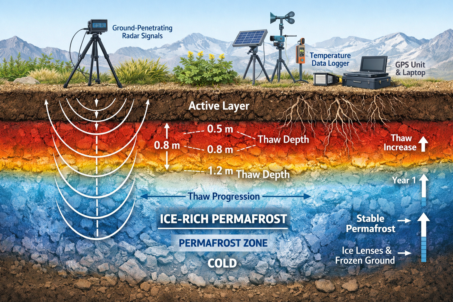
The active layer—the seasonally thawed zone above permafrost—is deepening across mountain regions. This expansion allows deeper root penetration, alters soil moisture regimes, and mobilizes previously frozen organic matter. For biodiversity surveyors, these changes mean that habitat distinctiveness scores and condition assessments require subsurface investigation, not just surface vegetation analysis.
Alpine Greening and Vegetation Dynamics
The phenomenon termed "alpine greening" describes the documented increase in vegetation productivity and cover across high-altitude zones as global temperatures rise [2]. This greening manifests through multiple pathways:
- Upslope treeline advancement into previously tundra-dominated areas
- Increased shrub density in alpine grassland communities
- Extended growing seasons enabling greater biomass accumulation
- Species composition shifts toward more thermophilic taxa
Recent analysis reveals that heat conditions at treeline positions consistently measure about 35% below genus- and species-level thermal optima, providing a unified thermal threshold mechanism that explains global uppermost tree elevation patterns [1]. This consistency offers surveyors a predictive framework for projecting future treeline positions under various climate scenarios.
Understanding biodiversity net gain principles becomes more complex when applied to these rapidly shifting alpine systems, where the very definition of "baseline condition" requires temporal qualification.
Plant Ecological Strategies and Carbon Dynamics
Alpine ecosystem responses to warming involve more than simple temperature-driven range shifts. Research demonstrates that plant ecological strategies—not climate alone—primarily drive soil organic carbon patterns across alpine gradients [4]. Competitive, stress-tolerant, and ruderal plant strategies interact with environmental conditions to determine ecosystem carbon storage capacity.
This finding has direct implications for biodiversity net gain calculations. Habitat creation or enhancement projects in alpine zones must consider not only species composition but also functional trait diversity and ecological strategy representation to achieve genuine biodiversity outcomes. A diverse alpine grassland with multiple ecological strategies may deliver greater ecosystem resilience and carbon storage than a species-rich but functionally homogeneous community.
Specialized Survey Protocols for Alpine Ecosystem Surveys for High-Altitude BNG
Ground-Penetrating Radar Applications
Ground-penetrating radar (GPR) has emerged as an essential tool for alpine biodiversity surveys addressing permafrost dynamics. GPR systems transmit electromagnetic pulses into the subsurface and record reflected signals, revealing:
- Active layer depth and seasonal variation
- Ice content distribution within frozen layers
- Subsurface water flow patterns affecting vegetation
- Soil structure changes over time
For biodiversity impact assessments, GPR data provides critical context for interpreting vegetation patterns. A sparse alpine plant community growing over shallow permafrost represents a fundamentally different habitat than morphologically similar vegetation over deep, well-drained soil. GPR surveys enable this distinction.
Protocol recommendation: Conduct GPR transects along elevation gradients at 50-meter intervals, with measurements repeated in early and late growing season to capture active layer dynamics. Integrate GPR data with vegetation quadrat surveys to establish correlations between subsurface conditions and plant community composition.
Vegetation Transect Design for Treeline Zones
Traditional vegetation survey methods require adaptation for treeline environments where spatial patterns change rapidly along elevation gradients. Effective transect design for Alpine Ecosystem Surveys for High-Altitude BNG: Protocols Addressing 2026 Permafrost Thaw and Treeline Shifts incorporates:
Stratified sampling approach:
- Closed forest zone: Standard woodland survey methods
- Treeline ecotone: High-intensity sampling capturing transition dynamics
- Krummholz zone: Specialized protocols for stunted tree forms
- Alpine tundra: Quadrat-based community sampling
Measurement parameters:
- Tree height, diameter, and age structure
- Seedling establishment density and success rates
- Shrub cover and composition
- Herbaceous layer diversity and cover
- Bare ground and rock exposure percentages
- Microsite characteristics (aspect, slope, soil depth)
The largest global treeline dataset—encompassing over 2,000 species records from 39 mountain regions—identifies dual control mechanisms of heat deficits and moisture gradients underlying treeline formation [1]. Survey protocols should explicitly measure both thermal and moisture variables to predict future treeline positions.
Thermal and Moisture Monitoring
Temperature and moisture regimes drive alpine ecosystem dynamics at multiple scales. Comprehensive monitoring programs deploy:
Temperature sensors:
- Air temperature at standard meteorological height (2m)
- Surface temperature at ground level
- Soil temperature at multiple depths (5cm, 15cm, 30cm, 50cm)
- Data loggers recording at hourly intervals
Moisture measurements:
- Volumetric soil moisture sensors
- Groundwater monitoring wells where applicable
- Snow depth and duration tracking
- Precipitation gauges
These environmental data layers enable surveyors to correlate vegetation patterns with specific climatic conditions and project how communities may respond to continued warming. For developers seeking biodiversity credits, this predictive capacity supports more robust habitat creation proposals.
Temporal Monitoring Frameworks
Static, single-timepoint surveys prove inadequate for alpine systems experiencing rapid change. Effective protocols for Alpine Ecosystem Surveys for High-Altitude BNG: Protocols Addressing 2026 Permafrost Thaw and Treeline Shifts establish permanent monitoring infrastructure:
| Component | Initial Survey | Year 3 | Year 5 | Year 10 |
|---|---|---|---|---|
| Vegetation composition | Full survey | Full survey | Full survey | Full survey |
| Tree seedling plots | Establish | Resurvey | Resurvey | Resurvey |
| GPR transects | Baseline | Resurvey | Resurvey | Resurvey |
| Soil carbon sampling | Baseline | – | Resurvey | Resurvey |
| Photo points | Establish | Document | Document | Document |
This adaptive framework acknowledges that biodiversity baselines in alpine zones are inherently dynamic. Rather than treating temporal change as survey error, the protocol embraces change as the fundamental characteristic requiring measurement.
Calculating Biodiversity Net Gain in Alpine Ecosystem Surveys for High-Altitude BNG
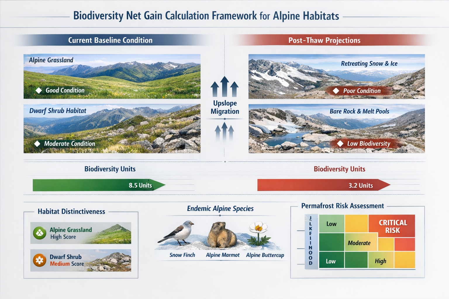
Habitat Distinctiveness in Permafrost-Affected Zones
The UK's biodiversity metric assigns distinctiveness scores to habitats based on their rarity, species richness, and ecosystem function. Alpine habitats present unique challenges for this classification system:
High distinctiveness alpine habitats:
- Alpine dwarf shrub heath
- Montane acid grassland
- Calcareous alpine grassland
- Alpine pioneer communities
- Snow-bed vegetation
Permafrost thaw impacts on distinctiveness:
- Nutrient mobilization may temporarily increase productivity but reduce specialist species
- Vegetation succession toward more common grassland types
- Potential loss of cold-adapted endemic species
- Increased invasibility by lowland generalist species
When conducting biodiversity net gain assessments, surveyors must document current distinctiveness while projecting likely trajectory under continued permafrost degradation. A habitat currently classified as "high distinctiveness" may transition toward "medium distinctiveness" within the 30-year timeframe typically used for net gain calculations.
Condition Assessment Adaptations
Standard habitat condition assessment sheets evaluate factors like vegetation structure, species composition, and disturbance indicators. Alpine adaptations include:
Additional condition criteria:
- ✅ Presence of cold-adapted specialist species
- ✅ Intact moss and lichen layers (indicators of stable conditions)
- ✅ Absence of lowland generalist species invasion
- ✅ Natural disturbance patterns (solifluction, frost heave)
- ✅ Appropriate bare ground percentage for alpine systems
Permafrost-specific indicators:
- 🔍 Active layer depth within historical range
- 🔍 Absence of thermokarst features (ground subsidence)
- 🔍 Stable soil moisture patterns
- 🔍 Minimal erosion from thaw-induced slumping
Research tracking permafrost thaw impacts over 10 years demonstrates that disturbance effects persist in stream ecosystems [3], suggesting that condition assessments should incorporate hydrological connectivity and downstream impacts in addition to on-site vegetation characteristics.
Incorporating Climate Trajectory Scenarios
Traditional biodiversity net gain calculations assume relatively stable environmental conditions over assessment periods. Alpine ecosystems require scenario-based approaches that acknowledge uncertainty:
Baseline scenario (current trajectory):
- Continued warming at current rates
- Gradual treeline advancement
- Moderate permafrost degradation
- Predictable vegetation succession
Accelerated change scenario:
- Rapid warming exceeding current projections
- Abrupt permafrost thaw events
- Significant ecosystem state changes
- Unpredictable community reassembly
Stabilization scenario:
- Effective climate mitigation
- Slowed warming rates
- Maintained cold-adapted communities
- Gradual adaptation processes
Developers proposing on-site or off-site biodiversity net gain delivery in alpine zones should present biodiversity unit calculations under multiple scenarios, with explicit acknowledgment of uncertainty ranges. This transparency supports more informed decision-making and appropriate risk management.
Biodiversity Unit Trading in Alpine Habitats
The emerging market for biodiversity units faces particular challenges in alpine contexts:
Supply-side constraints:
- Limited land availability at high altitudes
- Slow habitat creation timelines in cold environments
- High uncertainty in creation success rates
- Specialized management expertise requirements
Demand-side considerations:
- Few development projects occur at high altitudes
- Infrastructure projects (ski resorts, telecommunications) represent primary demand
- Strategic importance of protecting intact alpine habitats
- Preference for off-site compensation at lower elevations
The cost of biodiversity units in alpine zones may reflect these supply constraints, potentially incentivizing avoidance and minimization strategies over compensation approaches.
Practical Implementation for Developers and Land Managers
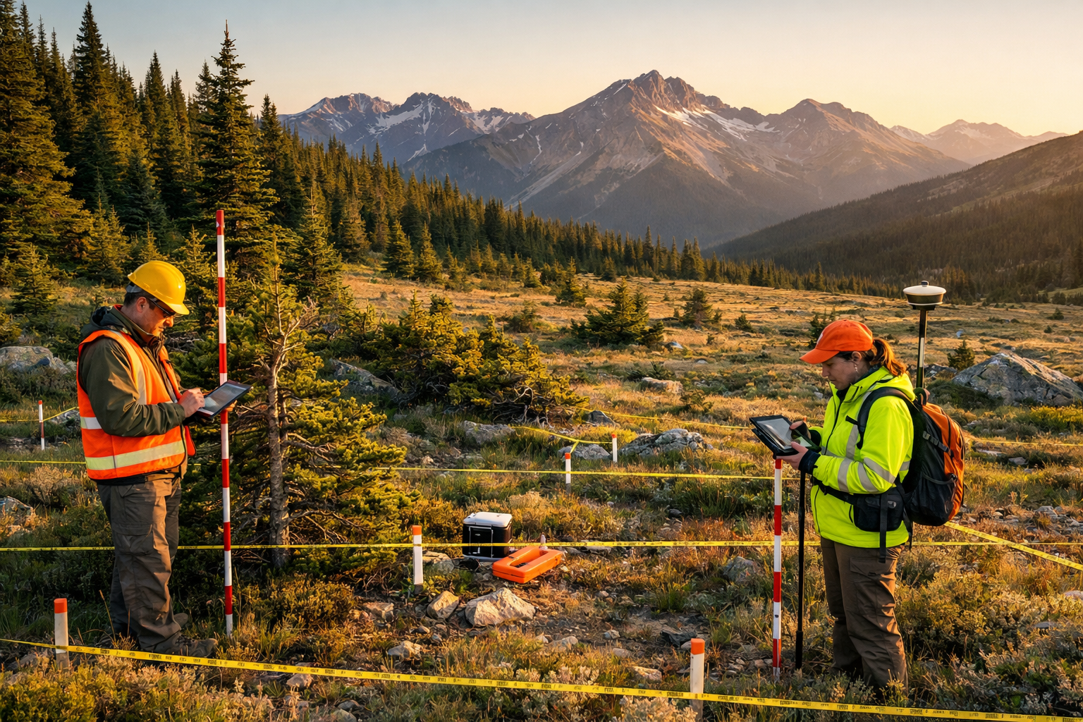
Pre-Development Survey Requirements
Developers planning projects in or near alpine zones should commission comprehensive baseline surveys that address Alpine Ecosystem Surveys for High-Altitude BNG: Protocols Addressing 2026 Permafrost Thaw and Treeline Shifts through:
- Desktop assessment: Review historical climate data, permafrost maps, and vegetation records
- Field survey: Conduct multi-season vegetation surveys with GPR and thermal monitoring
- Specialist consultation: Engage alpine ecologists familiar with regional species and dynamics
- Temporal baseline: Where possible, establish monitoring before project approval to document change rates
- Impact modeling: Project development footprint effects on permafrost stability and vegetation
These requirements align with broader guidance for developers implementing biodiversity net gain obligations, with alpine-specific technical enhancements.
Habitat Creation and Enhancement Strategies
Creating or enhancing alpine habitats to generate biodiversity units presents significant challenges but also opportunities:
Feasible enhancement approaches:
- Grazing management: Adjusting livestock pressure to favor diverse plant communities
- Invasive species control: Removing lowland species advancing upslope
- Erosion stabilization: Preventing thaw-induced soil loss
- Hydrological restoration: Maintaining natural water flow patterns
Challenging creation approaches:
- De novo habitat creation: Extremely slow establishment in cold environments
- Species reintroduction: Limited success with cold-adapted specialists
- Soil development: Centuries-scale processes difficult to accelerate
Land managers considering selling biodiversity units from alpine properties should focus on enhancement of existing habitats rather than creation projects, given the shorter timeframes to measurable biodiversity gains.
Monitoring and Adaptive Management
Post-project monitoring in alpine zones requires commitment to long-term data collection and willingness to adjust management based on observed outcomes:
Essential monitoring components:
- Annual vegetation surveys in permanent plots
- Thermal and moisture data logging
- Photo documentation from fixed points
- Periodic GPR resurveys (3-5 year intervals)
- Specialist species population tracking
Adaptive management triggers:
- Vegetation composition shifts exceeding projected ranges
- Unexpected permafrost thaw acceleration
- Invasive species establishment
- Failure of enhancement measures
- Extreme weather event impacts
The 3rd Alpine-Arctic Cryosphere Observatories Program conference in June 2026 will showcase integrated approaches combining field measurements, remote sensing, and ecosystem modeling to reveal how permafrost dynamics drive plant community shifts [7], providing valuable methodological updates for practitioners.
Regulatory Context and Future Directions
Current BNG Policy in High-Altitude Contexts
The UK's mandatory biodiversity net gain requirement, implemented for major developments in 2024, applies to projects regardless of elevation. However, secondary BNG legislation provides limited specific guidance for alpine and montane habitats.
Key policy considerations:
- Metric applicability: The statutory biodiversity metric includes alpine habitat types but may not fully capture permafrost-related dynamics
- Temporal requirements: 30-year habitat management plans may prove inadequate for rapidly changing alpine systems
- Equivalency principles: Whether lowland habitat creation can compensate for alpine habitat loss remains contentious
- Monitoring standards: No alpine-specific monitoring protocols exist in statutory guidance
Planners and developers should consult guidance addressing common BNG questions while recognizing that alpine applications may require case-by-case interpretation.
Emerging Research Priorities
Recent research highlights critical knowledge gaps affecting Alpine Ecosystem Surveys for High-Altitude BNG: Protocols Addressing 2026 Permafrost Thaw and Treeline Shifts:
Carbon budget uncertainties: Unaccounted emissions from abrupt permafrost thaw and wildfires could significantly impact global carbon budgets [6], suggesting that alpine biodiversity projects should integrate carbon considerations alongside habitat metrics.
Multifactorial ecosystem responses: Plant ecological strategies—not climate alone—drive soil organic carbon patterns [4], indicating that functional diversity metrics may better predict ecosystem resilience than species richness alone.
Thermal threshold refinement: While the 35% thermal deficit at treelines provides a general framework [1], regional variations require local calibration for accurate projection of future treeline positions.
International Perspectives
Alpine biodiversity conservation extends beyond UK borders, with relevant developments in other mountain regions:
- Swiss research: The WSL Institute for Snow and Avalanche Research maintains long-term alpine ecosystem monitoring programs [5] providing methodological models
- Arctic-alpine integration: Recognition that Arctic and alpine systems face parallel challenges drives coordinated research efforts [7]
- European habitat directives: Alpine habitats receive protection under EU legislation, creating cross-border conservation frameworks
UK practitioners can draw on this international expertise while adapting approaches to domestic regulatory requirements and regional ecological characteristics.
Conclusion
Alpine ecosystem surveys for high-altitude biodiversity net gain face unprecedented challenges as permafrost thaw and treeline shifts fundamentally alter habitat baselines. The protocols outlined here—integrating ground-penetrating radar, vegetation transects, thermal monitoring, and adaptive frameworks—provide surveyors and developers with tools to measure biodiversity accurately in these dynamic environments.
Key implementation priorities include:
✅ Embrace temporal dynamics: Recognize that alpine baselines are inherently unstable and build monitoring programs that track change rather than assuming stasis
✅ Integrate subsurface data: Use ground-penetrating radar and soil thermal sensors to understand permafrost conditions driving vegetation patterns
✅ Apply scenario-based projections: Calculate biodiversity units under multiple climate trajectories to acknowledge uncertainty
✅ Prioritize enhancement over creation: Focus habitat banking efforts on improving existing alpine habitats rather than attempting de novo creation
✅ Commit to long-term monitoring: Establish permanent plots and data collection infrastructure for multi-decadal tracking
For developers navigating biodiversity net gain requirements, early engagement with alpine ecology specialists and transparent acknowledgment of uncertainties will support more defensible assessments and successful project outcomes.
The urgency is clear: as 2026 research continues to document accelerating alpine change, the window for establishing robust baseline data narrows. Projects initiated today with comprehensive survey protocols will possess invaluable temporal datasets for adaptive management tomorrow.
Next Steps:
- Commission baseline alpine surveys incorporating GPR and thermal monitoring
- Engage specialists familiar with regional permafrost dynamics and alpine ecology
- Develop scenario-based biodiversity net gain calculations acknowledging climate uncertainty
- Establish permanent monitoring infrastructure before project commencement
- Participate in knowledge-sharing forums like the ACOP 2026 conference to remain current with methodological advances
The future of alpine biodiversity depends on measurement frameworks sophisticated enough to capture the complexity of these transforming ecosystems. By implementing the protocols detailed here, the conservation community can ensure that biodiversity net gain delivers genuine ecological benefits even as mountain environments experience unprecedented change.
References
[1] Treeline thermal threshold mechanism – https://www.pnas.org/doi/10.1073/pnas.2504685122
[2] Alpine greening patterns – https://egusphere.copernicus.org/preprints/2026/egusphere-2026-835/egusphere-2026-835.pdf
[3] Permafrost thaw impacts on streams – https://pmc.ncbi.nlm.nih.gov/articles/PMC12970577/
[4] Plant ecological strategies driving carbon patterns – https://besjournals.onlinelibrary.wiley.com/doi/10.1111/1365-2745.70270
[5] Mountain ecosystems research – https://www.slf.ch/en/mountain-ecosystems/
[6] Carbon budget concerns – https://permafrost.woodwellclimate.org/news-updates/
[7] ACOP 2026 conference – https://event.fourwaves.com/acop2026/pages/3d530a8b-fe33-4689-9192-31dc6cac045c
