
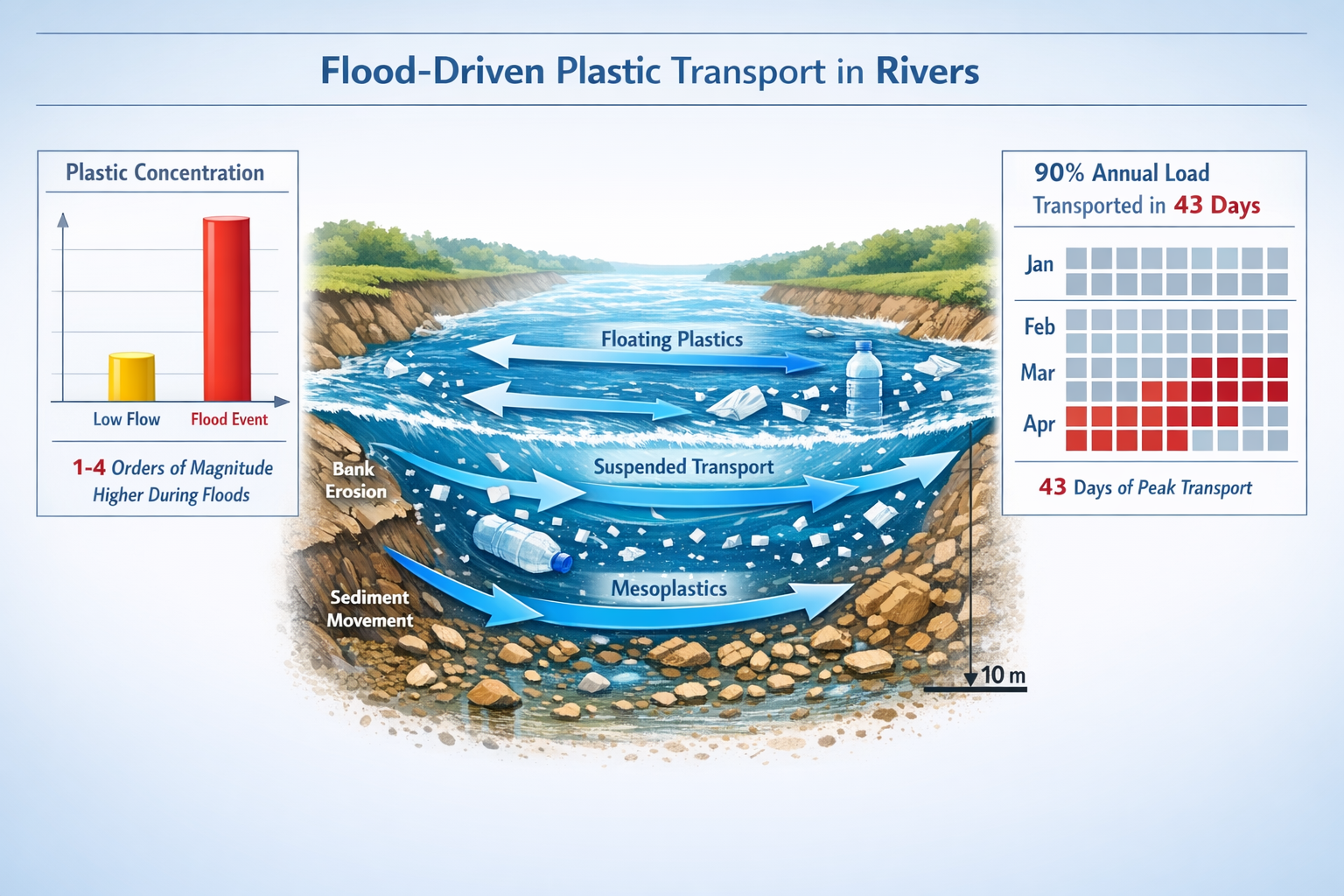
Recent research reveals that 90% of annual mesoplastic load in rivers is transported in just 43 days [3]. This extreme temporal concentration fundamentally changes how biodiversity surveyors must approach baseline assessments for Biodiversity Net Gain (BNG) compliance in 2026. When macroplastic debris surges through river systems during flood events, it doesn't just pollute waterways—it disrupts habitat quality, alters species composition, and compromises the very biodiversity metrics that developers and planners rely upon for accurate BNG calculations.
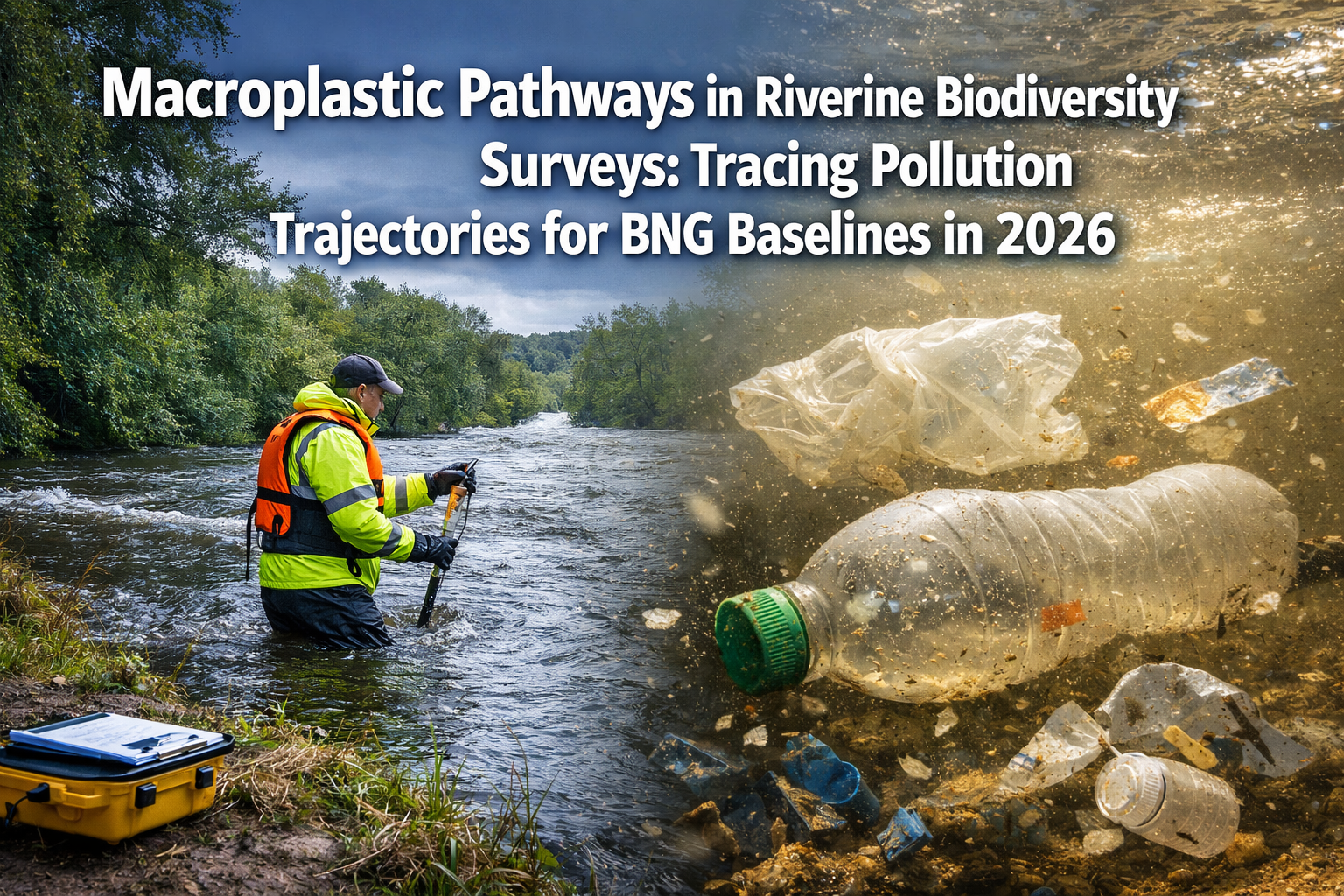
Understanding Macroplastic Pathways in Riverine Biodiversity Surveys: Tracing Pollution Trajectories for BNG Baselines in 2026 has become essential for ecological consultants, developers, and environmental planners working on projects near watercourses. The integration of plastic pollution monitoring into traditional biodiversity survey protocols represents a critical evolution in how we establish accurate baseline conditions for Biodiversity Net Gain assessments.
Key Takeaways
- Flood events drive 1-4 orders of magnitude increases in plastic concentrations, making timing critical for accurate pollution trajectory mapping in BNG baselines
- Suspended solids monitoring can serve as a cost-effective proxy for estimating macroplastic concentrations without dedicated plastic sampling protocols
- Regional polymer composition varies significantly, requiring site-specific characterization for effective mitigation design
- Integrated eDNA and tracer protocols enable surveyors to quantify both pollution impacts and biodiversity responses simultaneously
- BNG compliance now requires temporal sampling strategies that capture high-flow conditions rather than relying solely on standard survey windows
Understanding Macroplastic Pathways in Riverine Biodiversity Surveys
What Are Macroplastics and Why Do They Matter for BNG?
Macroplastics are plastic debris items larger than 5mm, including bottles, bags, packaging materials, and fragments that accumulate in river systems. Unlike microplastics, macroplastics are visible to the naked eye and create immediate physical habitat disruption. For biodiversity surveyors conducting baseline assessments, macroplastic presence indicates:
- Habitat degradation affecting species richness calculations
- Physical barriers to aquatic organism movement
- Altered flow dynamics impacting riparian vegetation
- Contamination pathways affecting water quality metrics
When establishing BNG baselines, surveyors must now account for plastic pollution as both a stressor and a confounding variable in biodiversity metrics.
The Flood-Driven Transport Paradigm
Research from Tokyo University of Science in 2026 has fundamentally changed our understanding of plastic movement through rivers. The study analyzed four Japanese rivers across six sampling occasions and found that high-flow conditions (floods) are the dominant driver of plastic transport [3]. This discovery has profound implications for survey timing and methodology.
Traditional biodiversity surveys typically occur during optimal weather conditions—exactly when plastic concentrations are lowest. This creates a systematic underestimation of pollution impacts on baseline habitat quality.
Key transport dynamics include:
| Flow Condition | Plastic Concentration | Survey Implications |
|---|---|---|
| Low-flow (standard survey conditions) | Baseline levels | Underestimates pollution impact |
| High-flow (flood events) | 1-4 orders of magnitude higher | Captures true pollution trajectory |
| Post-flood recession | Elevated with debris deposition | Reveals accumulation patterns |
Temporal Concentration: The 43-Day Window
Perhaps the most striking finding from recent research is that in one studied river system, 90% of the annual mesoplastic load was transported in just 43 days [3]. This extreme temporal concentration means that:
- Standard survey windows miss the majority of plastic transport
- Annual pollution loads cannot be extrapolated from single-visit surveys
- BNG baselines require multi-temporal sampling strategies
- Mitigation designs must account for episodic high-load events
For surveyors, this necessitates a shift from snapshot assessments to trajectory-based monitoring that captures both baseline conditions and pollution pulse events.
Implementing Macroplastic Pathways in Riverine Biodiversity Surveys for BNG Compliance
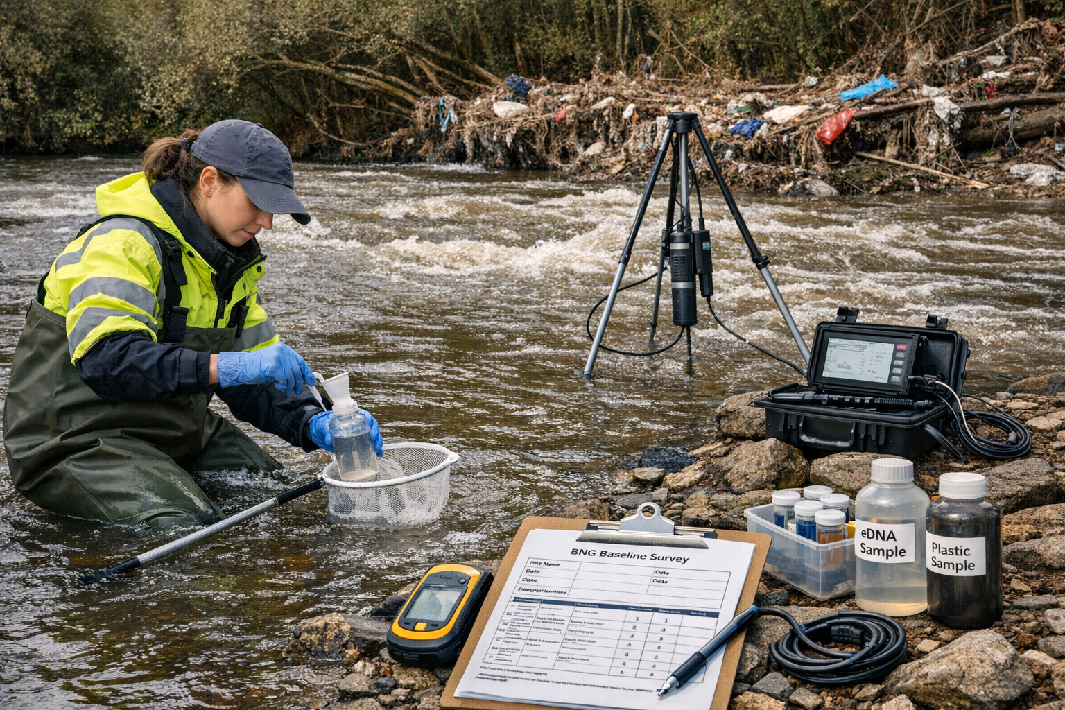
Direct Sampling Methodologies
The reproducible field methodology established by Tokyo University researchers provides a template for integrating plastic monitoring into biodiversity surveys [3]. The protocol involves:
🔬 Core Sampling Components:
- Direct water sampling during elevated flow conditions using calibrated collection nets (mesh size 0.3-5mm)
- Turbidity and suspended solids (SS) measurements as proxy indicators for plastic concentrations
- Visual debris surveys along transects during post-flood recession periods
- Polymer identification using portable FTIR spectroscopy for composition analysis
This approach allows surveyors to collect plastic data concurrently with traditional biodiversity metrics, creating integrated baseline assessments that reflect true habitat conditions.
The Suspended Solids Proxy Method
One of the most practical discoveries for cost-effective monitoring is that turbidity and suspended solids measurements show significant correlation with mesoplastic particles [3]. This correlation enables surveyors to:
- Estimate plastic concentrations using existing water quality equipment
- Reduce specialized sampling costs
- Increase temporal sampling frequency
- Integrate plastic monitoring into routine site visits
For developers working on BNG compliance, this proxy method offers a pathway to comprehensive pollution baseline data without prohibitive costs.
eDNA Integration for Impact Quantification
Environmental DNA (eDNA) sampling provides a powerful complement to macroplastic pathway tracing. By collecting water samples for both plastic analysis and eDNA extraction, surveyors can:
- Quantify species richness in plastic-impacted versus control reaches
- Detect sensitive indicator species that respond to pollution gradients
- Establish cause-effect relationships between plastic loads and biodiversity metrics
- Document temporal recovery following mitigation implementation
This integrated approach strengthens the scientific foundation for BNG baseline assessments and provides defensible data for planning applications.
Geographic and Compositional Variability
Multi-year synchronous data collection from eight river systems across four continents has revealed significant regional variation in plastic composition [5]. Key findings include:
- Low-density polyethylene (LDPE) is the most common polymer class globally
- Regional variations are substantial: 50.4% LDPE in Vietnam's Red River versus 52.6% polypropylene in Indonesia's Citarum River
- Polymer composition affects transport dynamics, degradation rates, and ecological impacts
For UK-based surveyors, this highlights the importance of site-specific polymer characterization rather than relying on global averages. Different plastic types require different mitigation approaches, making compositional analysis essential for effective BNG strategy development.
Tracing Pollution Trajectories for BNG Baselines in 2026
Establishing Spatial Distribution Patterns
Frontiers research initiatives are systematically investigating macroplastic distribution gradients along watercourses to identify global riverine plastic hotspot areas [1]. This longitudinal approach enables surveyors to:
Map pollution trajectories from source to accumulation zones by:
- Conducting multi-point sampling along river reaches
- Identifying debris deposition hotspots in low-velocity zones
- Characterizing riparian accumulation patterns
- Documenting tributary contributions to main stem loads
Understanding these spatial patterns is critical for architects and planners designing developments near watercourses, as it reveals which portions of a site are most vulnerable to pollution impacts.
Temporal Sampling Strategies
Given the extreme temporal concentration of plastic transport, BNG baseline surveys must adopt event-responsive sampling protocols:
-
Pre-development baseline phase (minimum 12 months):
- Monthly low-flow sampling for baseline conditions
- Targeted high-flow sampling during 3-5 flood events
- Post-flood debris surveys within 48 hours of peak discharge
-
Seasonal variation capture:
- Spring snowmelt or monsoon season intensive sampling
- Summer low-flow reference conditions
- Autumn/winter storm event monitoring
-
Long-term trajectory establishment:
- Multi-year data collection for sites with complex hydrology
- Integration with regional monitoring networks
- Comparison with upstream/downstream reference sites
This temporal framework ensures that baseline assessments capture the full range of pollution conditions that will affect post-development biodiversity outcomes.
Microplastic Considerations
While macroplastics create visible habitat disruption, research shows that annual microplastic loads follow similar but less pronounced patterns to mesoplastics [3]. The muted seasonal trends suggest different transport and retention mechanisms.
For comprehensive BNG baselines, surveyors should consider:
- Microplastic sampling in sediment cores (accumulation zones)
- Water column sampling for suspended microplastics
- Biological tissue sampling in indicator species (bioaccumulation)
- Correlation analysis between macro- and microplastic loads
This multi-scale approach provides complete characterization of plastic pollution impacts on baseline biodiversity.
International Coordination and Data Sharing
The establishment of continuous, synchronous data collection across eight countries from 2020-2023 [5] demonstrates the value of coordinated monitoring efforts. UK surveyors can benefit from:
- Standardized methodologies enabling cross-site comparison
- Shared databases for polymer composition reference
- Collaborative research on transport modeling
- Best practice exchange for mitigation design
Participation in international networks strengthens individual baseline assessments by providing context and validation for site-specific findings.
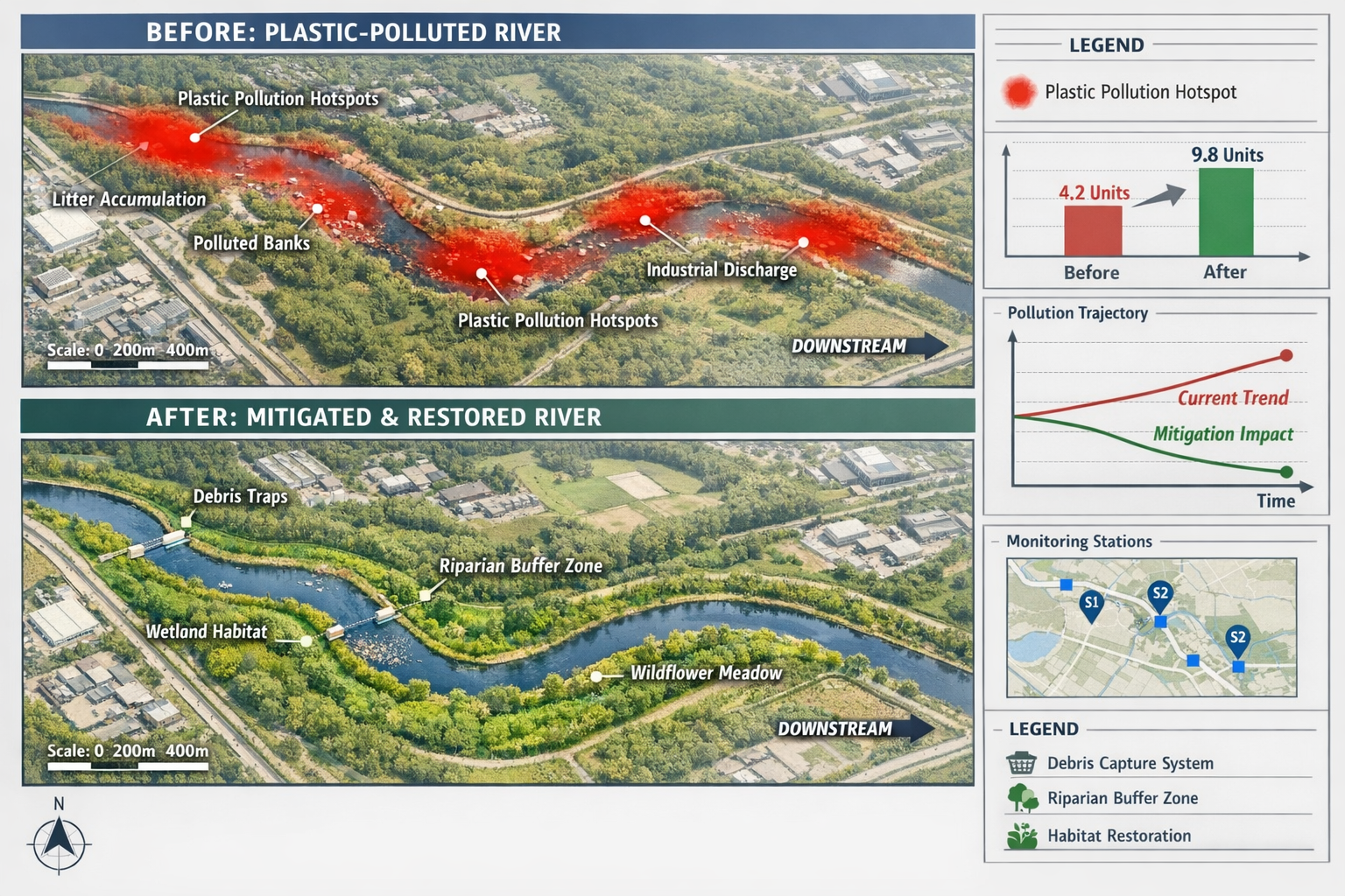
Designing Mitigation Strategies Based on Pollution Trajectories
Site-Specific Mitigation Approaches
Once pollution trajectories are mapped, surveyors can work with developers to design targeted mitigation measures that address both plastic impacts and BNG requirements:
🌿 Riparian Buffer Enhancement:
- Strategic placement of vegetation barriers in debris deposition zones
- Native species selection for debris capture and habitat creation
- Root system design to stabilize banks and filter runoff
🔄 Debris Capture Systems:
- Engineered structures at pollution trajectory convergence points
- Maintenance protocols integrated with habitat management
- Monitoring stations to quantify capture efficiency
💧 Hydrological Modifications:
- Flow management to reduce erosive forces during flood events
- Sediment control to reduce suspended solids and associated plastics
- Wetland creation for natural filtration
Quantifying Mitigation Effectiveness
For BNG compliance, mitigation measures must demonstrate measurable biodiversity improvement. Integration of plastic monitoring enables:
- Before-after-control-impact (BACI) designs comparing plastic loads and species richness
- Biodiversity unit calculations that account for pollution reduction
- Long-term monitoring protocols documenting trajectory improvement
- Adaptive management triggers based on plastic load thresholds
This evidence-based approach strengthens BNG assessment quality and provides defensible data for regulatory approval.
Emerging Research and Future Directions
The European Geosciences Union conference in May 2026 will feature presentations on macroplastic transport, deposition, and remobilization processes along specific watercourses including the Rhine River [2]. These research updates will provide:
- Refined transport models for UK river types
- New proxy indicators for cost-effective monitoring
- Case studies of successful mitigation implementations
- Policy recommendations for BNG guidance updates
Surveyors should stay current with this emerging research to ensure their methodologies reflect best available science.
Practical Implementation for Surveyors and Developers
Cost-Benefit Analysis of Integrated Monitoring
Developers often question the additional cost of plastic monitoring in biodiversity surveys. However, the integrated approach offers significant advantages:
Cost savings through:
- Reduced site visits by combining plastic and biodiversity sampling
- Use of SS proxy methods instead of specialized plastic analysis
- Early identification of pollution issues before design finalization
- Reduced risk of BNG assessment rejection due to incomplete baseline data
Risk reduction through:
- Comprehensive baseline documentation protecting against future liability
- Proactive mitigation design preventing costly post-construction remediation
- Stronger planning applications with robust environmental data
- Improved stakeholder confidence in development sustainability
For guidance on achieving BNG without risk, integrated plastic monitoring represents a strategic investment rather than an additional burden.
Regulatory Landscape and Compliance Requirements
While specific plastic monitoring requirements are not yet mandated in UK BNG guidance, the trajectory is clear. Forward-thinking developers and surveyors should anticipate:
- Increased scrutiny of water quality impacts in planning applications
- Catchment-scale considerations for downstream biodiversity effects
- Long-term monitoring requirements including pollution indicators
- Stakeholder expectations for comprehensive environmental assessment
By proactively incorporating Macroplastic Pathways in Riverine Biodiversity Surveys: Tracing Pollution Trajectories for BNG Baselines in 2026, projects position themselves ahead of regulatory evolution.
Training and Capacity Building
Implementing these integrated protocols requires surveyor training in:
- Plastic sampling techniques and safety protocols for flood conditions
- Polymer identification using field-portable equipment
- Spatial analysis for trajectory mapping and hotspot identification
- Data integration combining plastic loads with biodiversity metrics
- Mitigation design addressing both pollution and habitat requirements
Professional development in these areas enhances surveyor value and project quality.
Case Study Applications
Consider a typical riverside development scenario:
Project: Residential development adjacent to a tributary of the Thames
BNG requirement: 10% net gain with riparian habitat creation
Challenge: Existing plastic pollution from upstream sources
Integrated approach:
- Baseline surveys conducted during both low-flow and two flood events
- SS monitoring established as ongoing proxy for plastic loads
- eDNA sampling quantified species richness in impacted versus reference reaches
- Trajectory mapping identified debris accumulation zones within development footprint
- Mitigation design incorporated debris capture with native riparian planting
- Post-construction monitoring documented 40% reduction in plastic loads and 25% increase in species richness
This integrated approach not only achieved BNG compliance but created measurable environmental improvement beyond baseline conditions.
Tools and Resources for Implementation
Essential Equipment and Protocols
Surveyors implementing plastic pathway monitoring require:
Field Equipment:
- Calibrated collection nets (multiple mesh sizes)
- Turbidity meters and SS sampling kits
- GPS units for spatial data collection
- Waterproof field computers for real-time data entry
- Safety equipment for flood condition sampling
Laboratory Analysis:
- Portable FTIR spectroscopy for polymer identification
- Microscopy for particle counting and characterization
- eDNA extraction and analysis facilities
- Data management systems for longitudinal tracking
Protocol Documentation:
- Standard operating procedures aligned with research methodologies [3]
- Quality assurance/quality control protocols
- Health and safety risk assessments for flood sampling
- Data reporting templates for BNG submissions
Collaboration with Research Networks
Surveyors can enhance their practice by connecting with:
- University research groups conducting plastic transport studies
- Regional monitoring networks sharing data and methodologies
- International initiatives like the multi-continent synchronous sampling programs [5]
- Professional organizations developing best practice guidance
These collaborations provide access to cutting-edge methodologies and validation of survey approaches.
Integration with Existing BNG Frameworks
The plastic monitoring protocols complement rather than replace existing BNG assessment tools. Integration points include:
- Habitat condition assessments incorporating pollution indicators
- Biodiversity metric calculations adjusted for stressor impacts
- Mitigation hierarchy application addressing pollution at source
- Monitoring and management plans including plastic load tracking
For comprehensive guidance on creating biodiversity plans, plastic pathway analysis should be embedded throughout the assessment process.
Conclusion
Macroplastic Pathways in Riverine Biodiversity Surveys: Tracing Pollution Trajectories for BNG Baselines in 2026 represents a critical evolution in environmental assessment practice. The discovery that 90% of annual plastic loads transport in just 43 days fundamentally changes how surveyors must approach baseline characterization. Traditional snapshot surveys conducted during optimal conditions systematically underestimate pollution impacts, compromising the accuracy of BNG assessments and the effectiveness of mitigation designs.
The integration of plastic monitoring into biodiversity surveys is no longer optional—it's essential for establishing defensible baselines that reflect true habitat conditions. The methodologies are proven, the equipment is accessible, and the cost-benefit analysis favors proactive implementation. Surveyors who adopt these integrated protocols position themselves at the forefront of professional practice while providing developers with robust data for regulatory compliance.
Actionable Next Steps
For Biodiversity Surveyors:
- Invest in training on plastic sampling methodologies and flood condition protocols
- Acquire essential equipment including SS monitoring tools and collection nets
- Establish partnerships with laboratories capable of polymer analysis and eDNA processing
- Develop temporal sampling strategies that capture both baseline and high-flow conditions
- Document methodologies in standard operating procedures aligned with research best practices
For Developers and Planners:
- Budget for integrated monitoring in project planning phases to avoid costly retrofits
- Engage surveyors early to design sampling strategies around site-specific hydrology
- Consider catchment-scale impacts when evaluating sites near watercourses
- Incorporate findings into mitigation designs that address both plastic and biodiversity
- Establish long-term monitoring to document trajectory improvements and BNG outcomes
For Regulatory Bodies and Stakeholders:
- Update guidance documents to reflect emerging science on plastic-biodiversity interactions
- Develop standardized protocols for plastic monitoring in BNG assessments
- Create data sharing platforms enabling cross-project learning and validation
- Incentivize proactive monitoring through streamlined approval processes
- Support research initiatives that refine methodologies and quantify mitigation effectiveness
The convergence of plastic pollution science and biodiversity assessment practice creates unprecedented opportunities for environmental improvement. By tracing pollution trajectories and integrating findings into BNG baselines, the development sector can move beyond mere compliance toward genuine ecological enhancement. The tools, knowledge, and frameworks are available—implementation is the next frontier.
For additional support in implementing these advanced assessment protocols, contact our team of specialist surveyors who can provide site-specific guidance tailored to your project requirements.
References
[1] Macroplastic Fate And Impacts In Riverine Ecosystemsundefined – https://www.frontiersin.org/research-topics/77922/macroplastic-fate-and-impacts-in-riverine-ecosystemsundefined
[2] Egu26 9992 – https://meetingorganizer.copernicus.org/EGU26/EGU26-9992.html
[3] 2026 02 Reveals Biggest Drivers Plastic Pollution – https://phys.org/news/2026-02-reveals-biggest-drivers-plastic-pollution.html
[5] Assessing Macroplastic Debris Collected From Eight Diverse River Systems Across Four Continents Insights From Synchronous Three Year Community Led Research Efforts – https://bosl.ucsb.edu/wp-content/uploads/2025/07/Assessing-macroplastic-debris-collected-from-eight-diverse-river-systems-across-four-continents_-Insights-from-synchronous-three-year-community-led-research-efforts.pdf
