
The natural world faces unprecedented challenges that scientists are only beginning to detect. From ocean darkening in remote marine regions to microscopic soil changes threatening entire food systems, emerging biodiversity threats often remain invisible until they reach crisis levels. In 2026, conservation professionals have a critical advantage: the 17th annual horizon scan has identified fifteen priority issues that demand immediate attention—and more importantly, actionable survey protocols to address them before they escalate.
Implementing 2026 Horizon Scan Insights: Actionable Survey Protocols for Emerging Biodiversity Threats represents a paradigm shift in conservation strategy. Rather than reacting to ecological disasters, practitioners can now proactively monitor, assess, and mitigate risks through integrated frameworks that align with biodiversity net gain requirements and modern development practices.
Key Takeaways
- Horizon scanning identifies early-warning signals for 15 priority biodiversity threats including ocean darkening, soil moisture decline, and macroalgal habitat loss before they reach policy agendas
- Integrated survey protocols combine traditional field methods with emerging technologies like TinyML sensors, digital twins, and optical AI chips for comprehensive threat detection
- Deep sea mining and soil inoculation require specialized monitoring frameworks that can be embedded within existing biodiversity net gain assessments
- The $125 billion Tropical Forests Forever Facility demonstrates how horizon scan insights drive innovative conservation financing mechanisms
- Practical implementation pathways connect horizon scan findings to actionable survey protocols that developers, ecologists, and policymakers can deploy immediately
Understanding the 2026 Horizon Scan Framework
What Makes Horizon Scanning Essential for Biodiversity Conservation
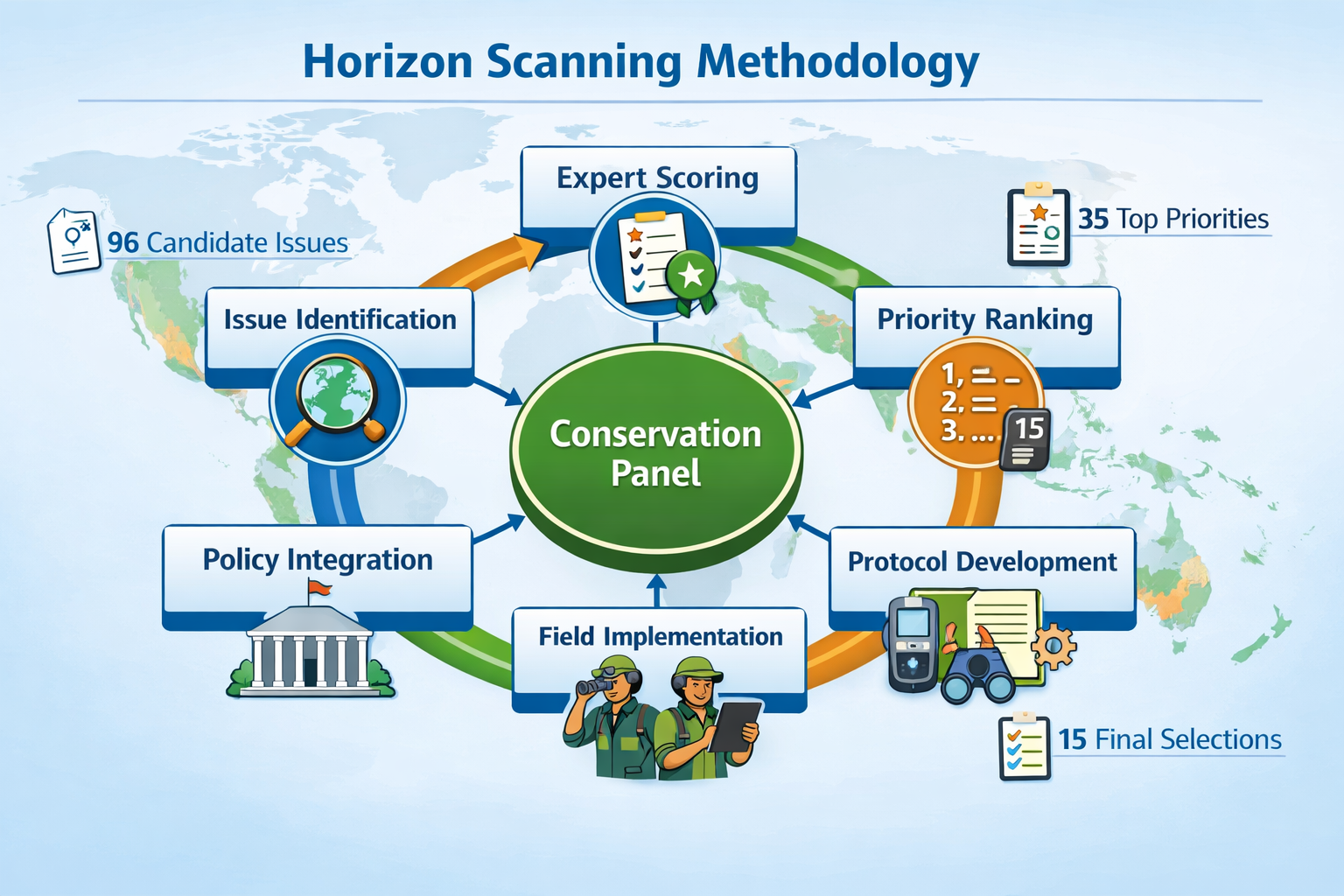
Horizon scanning serves as an early warning system for conservation science. Led by Professor Bill Sutherland and Dr. Ann Thornton at Cambridge University, the 2026 scan brought together 26 conservation scientists, practitioners, and policymakers to evaluate emerging threats that haven't yet captured mainstream attention.
The rigorous foresight process began with 96 candidate issues. Through systematic scoring and expert discussion, the panel narrowed these to 35 top priorities before identifying the final 15 critical threats. This methodology ensures that conservation resources focus on issues with the highest potential impact on nature and people.
Why traditional reactive approaches fall short:
- 🔴 Ecological damage often becomes irreversible before detection
- 🔴 Policy responses lag years behind scientific discovery
- 🔴 Funding flows to visible crises rather than preventable threats
- 🔴 Fragmented monitoring systems miss interconnected risks
The 2026 horizon scan addresses these gaps by identifying signals that require immediate protocol development and field implementation.
Key Threats Identified in the 2026 Scan
The fifteen priority issues span terrestrial, freshwater, and marine ecosystems. Several stand out for their urgency and the need for specialized survey protocols:
Marine and Ocean Threats:
- Ocean darkening: Declining light penetration across wide ocean regions affects marine productivity and food webs in ways scientists are still working to understand
- Macroalgal habitat loss: Seaweed and kelp forest ecosystems cover more area than coral reefs and coastal wetlands combined, yet face threats from climate change, overgrazing, and commercial farming
- Southern Ocean salinity shifts: Satellite imaging reveals unexpected surface water salinity increases over the past decade with unknown causes
Terrestrial and Soil Threats:
- Soil moisture decline: Widespread reduction across southern South America, central North America, Africa, and Asia threatens ecosystems, food production, and water security
- Soil inoculation impacts: Emerging practices require careful monitoring to prevent unintended ecological consequences
Technology and Innovation:
- Tiny Machine Learning (TinyML): Low-power devices enabling real-time biodiversity detection in remote landscapes
- Digital twins: Computer simulations of ecosystems for monitoring and planning
- Optical AI chips: Energy-efficient artificial intelligence for biodiversity applications
Economic and Policy Mechanisms:
- Tropical Forests Forever Facility: A $125 billion investment fund rewarding tropical countries for forest protection
- Forest finance mechanisms: Broader shifts in conservation economic models
- Global food demand shifts: Dietary pattern changes affecting land use and biodiversity
Understanding these threats provides the foundation for developing targeted survey protocols that integrate with biodiversity impact assessment frameworks.
Developing Actionable Survey Protocols for Priority Threats

Deep Sea Mining: Monitoring Protocols for Benthic Ecosystems
Deep sea mining represents one of the most pressing yet understudied threats to marine biodiversity. As commercial interest grows in extracting minerals from ocean floors, ecologists need robust protocols to establish baseline conditions and monitor impacts.
Essential Survey Components:
-
Baseline Habitat Assessment
- High-resolution seafloor mapping using autonomous underwater vehicles (AUVs)
- Sediment core sampling to document benthic community composition
- Water column profiling for suspended particle tracking
- Acoustic monitoring for marine mammal and fish presence
-
Impact Monitoring Framework
- Pre-extraction biodiversity inventories across proposed mining zones
- Continuous turbidity monitoring during operations
- Post-extraction recovery assessments at 6-month, 1-year, and 5-year intervals
- Reference site comparisons in unmined areas
-
Data Integration Requirements
- Standardized taxonomic protocols for deep-sea species identification
- Coordinated international databases for cross-site comparisons
- Integration with existing marine protected area monitoring
- Compatibility with biodiversity net gain assessment methodologies
Technology Applications:
TinyML devices offer particular promise for deep sea monitoring. These low-power sensors can operate for extended periods without internet connectivity, detecting species presence through acoustic signatures and environmental changes. However, questions remain about data access, transparency, and the energy demands of deploying thousands of devices across vast ocean areas.
Soil Inoculation: Field Protocols for Microbial Monitoring
Soil inoculation—introducing beneficial microorganisms to enhance plant growth and ecosystem function—has gained traction as a restoration tool. Yet the practice requires careful monitoring to prevent unintended consequences like pathogen introduction or native microbial community disruption.
Comprehensive Monitoring Protocol:
Phase 1: Pre-Inoculation Assessment (Months 1-3)
- Soil microbiome baseline analysis using DNA sequencing
- Soil chemistry profiling (pH, nutrients, organic matter)
- Native plant community inventory
- Soil moisture and temperature monitoring station installation
Phase 2: Inoculation and Initial Monitoring (Months 4-12)
- Controlled application with treatment and reference plots
- Monthly microbial community sampling
- Plant health indicators (growth rates, disease incidence)
- Soil function tests (nutrient cycling, water retention)
Phase 3: Long-term Tracking (Years 2-5)
- Quarterly microbial diversity assessments
- Annual vegetation surveys
- Soil carbon sequestration measurements
- Comparison against uninoculated reference sites
Integration with Net Gain Frameworks:
Soil inoculation monitoring can enhance biodiversity net gain planning by providing quantifiable metrics for habitat condition improvements. When combined with traditional habitat assessments, microbial monitoring offers a more complete picture of ecosystem health.
Ocean Darkening: Marine Light Penetration Survey Methods
Ocean darkening—the reduction in light penetration across wide marine regions—affects photosynthesis, species behavior, and entire food web structures. Monitoring this phenomenon requires specialized optical equipment and coordinated measurement protocols.
Survey Protocol Framework:
| Survey Component | Methods | Frequency | Key Metrics |
|---|---|---|---|
| Light Penetration | Secchi disk depth, PAR sensors | Monthly | Euphotic zone depth, light attenuation coefficient |
| Water Clarity | Turbidity meters, chlorophyll sensors | Bi-weekly | Suspended particles, phytoplankton density |
| Primary Productivity | Oxygen production, carbon uptake | Quarterly | Photosynthetic rates, biomass production |
| Species Response | Visual surveys, camera traps | Seasonal | Distribution shifts, behavioral changes |
Technology Integration:
Digital twins—computer simulations of real-world ecosystems—provide powerful tools for modeling ocean darkening impacts. By combining field survey data with simulation models, researchers can predict how light reduction affects marine communities and test mitigation strategies before implementation.
Macroalgal Habitat Loss: Kelp Forest Assessment Protocols
Kelp forests and seaweed ecosystems face multiple stressors: warming waters, overgrazing by sea urchins, and commercial harvesting pressure. These habitats support extraordinary biodiversity and provide critical ecosystem services including carbon sequestration and coastal protection.
Comprehensive Kelp Forest Survey Protocol:
Structural Assessment:
- Canopy density measurements using underwater drones
- Stipe (stem) counts and size distribution
- Holdfast substrate characterization
- Three-dimensional habitat mapping
Biological Community Surveys:
- Fish assemblage visual census
- Invertebrate quadrat sampling
- Epiphyte (attached organism) diversity assessment
- Herbivore population monitoring (sea urchins, abalone)
Environmental Conditions:
- Temperature loggers (continuous)
- Nutrient concentration sampling
- Wave exposure calculations
- Sedimentation rate measurements
Threat-Specific Indicators:
- Climate stress markers (bleaching, tissue degradation)
- Grazing pressure indices
- Commercial harvest impact zones
- Disease prevalence screening
This protocol aligns with biodiversity net gain frameworks by establishing clear baseline conditions and measurable improvement targets for marine habitat restoration projects.
Integrating Horizon Scan Insights with Biodiversity Net Gain Frameworks

Connecting Early Warning Signals to Development Planning
The true power of implementing 2026 Horizon Scan Insights: Actionable Survey Protocols for Emerging Biodiversity Threats lies in integration with existing regulatory frameworks. Developers, planners, and ecologists can embed horizon scan monitoring into biodiversity net gain assessments, creating proactive rather than reactive conservation outcomes.
Integration Pathway:
Step 1: Horizon Scan Threat Screening
Before conducting standard habitat surveys, assess whether the development site or surrounding landscape faces any of the 15 priority threats identified in the horizon scan. This screening takes minimal time but can reveal critical monitoring needs.
Step 2: Enhanced Baseline Surveys
Incorporate threat-specific protocols into baseline assessments. For example, if the site includes freshwater habitats in regions experiencing soil moisture decline, add soil moisture monitoring stations and enhanced aquatic invertebrate surveys to detect early stress signals.
Step 3: Targeted Mitigation Design
Design mitigation and enhancement measures that address both standard biodiversity impacts and emerging threats. A development near coastal areas might include kelp forest restoration to offset macroalgal habitat loss while meeting net gain requirements.
Step 4: Adaptive Monitoring Programs
Establish long-term monitoring that tracks both traditional biodiversity metrics and horizon scan indicators. This dual approach ensures developments contribute to understanding and mitigating emerging threats.
Practical Applications for Developers and Ecologists
Case Study Framework: Coastal Development Project
A proposed residential development on a coastal site provides an example of integrated implementation:
Traditional Approach:
- Habitat survey identifies coastal grassland and rocky shore
- Biodiversity metric calculation shows 10% net loss
- On-site habitat creation designed to achieve 10% net gain
Horizon Scan-Enhanced Approach:
- Habitat survey includes ocean darkening assessment of adjacent marine areas
- Macroalgal habitat mapping extends survey scope offshore
- Biodiversity metric calculation incorporates kelp forest condition
- Mitigation package includes kelp restoration and TinyML sensor deployment
- Long-term monitoring tracks both terrestrial and marine biodiversity
- Project contributes data to regional ocean darkening research network
The enhanced approach requires modest additional investment but delivers multiple benefits:
- ✅ Stronger regulatory compliance
- ✅ Reduced long-term ecological risk
- ✅ Enhanced corporate sustainability credentials
- ✅ Contribution to scientific understanding
- ✅ Potential for innovative biodiversity credit generation
Technology Deployment: TinyML and Digital Twins
TinyML Implementation Guide:
Tiny Machine Learning devices represent a breakthrough for remote biodiversity monitoring. These compact, low-power sensors can identify species through acoustic signatures, detect environmental changes, and operate for months without maintenance.
Deployment Protocol:
- Site Selection: Identify monitoring locations based on horizon scan threat assessment
- Device Configuration: Program sensors for target species or environmental parameters
- Installation: Mount devices following manufacturer specifications and animal welfare guidelines
- Data Management: Establish protocols for data retrieval, storage, and analysis
- Quality Control: Validate automated identifications with expert review
- Integration: Connect TinyML data with traditional survey results
Considerations:
- Data ownership and access transparency
- Energy source sustainability (solar, battery replacement schedules)
- Potential for technology obsolescence
- Training requirements for field staff
Digital Twin Applications:
Digital twins—computer simulations mirroring real ecosystems—enable scenario testing before implementing conservation interventions. For developers creating biodiversity plans, digital twins can:
- Model how proposed habitat creation will perform under different climate scenarios
- Test the effectiveness of various management interventions
- Predict species colonization patterns
- Optimize resource allocation across multiple sites
- Demonstrate net gain outcomes to stakeholders
Leveraging Innovative Conservation Finance
The Tropical Forests Forever Facility—a $125 billion investment fund established by international partners led by Brazil—exemplifies how horizon scan insights drive new conservation financing mechanisms. This facility rewards tropical countries for forest protection, offering improved self-determination and transparency compared to previous carbon credit schemes.
Implications for Biodiversity Net Gain:
This financing model suggests new pathways for funding biodiversity improvements:
Regional Biodiversity Funds: Similar investment vehicles could support landscape-scale conservation across multiple development projects, pooling resources for greater impact.
Performance-Based Payments: Rather than one-time habitat creation, ongoing payments could reward measurable biodiversity improvements over time, incentivizing long-term stewardship.
International Partnerships: Cross-border collaboration on emerging threats like ocean darkening or soil moisture decline could attract international conservation funding to supplement local net gain requirements.
Developers and landowners interested in selling biodiversity units should monitor these evolving finance mechanisms, as they may create new revenue opportunities for high-quality habitat creation and management.
Overcoming Implementation Challenges
Common Barriers and Solutions
Challenge 1: Technical Expertise Gaps
Many ecology teams lack specialized knowledge for monitoring emerging threats like ocean darkening or deploying TinyML devices.
Solution:
- Partner with academic institutions conducting horizon scan research
- Invest in targeted training programs for field staff
- Utilize consultant specialists for initial protocol development
- Join professional networks sharing implementation experiences
Challenge 2: Cost Concerns
Enhanced monitoring appears to add project expenses without immediate regulatory requirements.
Solution:
- Frame as risk management reducing long-term ecological liability
- Identify efficiency gains from technology (TinyML reduces field visit frequency)
- Explore grant funding for innovative monitoring approaches
- Consider biodiversity unit market advantages for projects demonstrating cutting-edge practices
Challenge 3: Data Management Complexity
Integrating traditional surveys with emerging threat monitoring creates data handling challenges.
Solution:
- Adopt standardized data formats compatible with national biodiversity databases
- Implement cloud-based platforms for multi-site data aggregation
- Establish clear data governance protocols addressing access and privacy
- Utilize digital twin platforms that integrate diverse data streams
Challenge 4: Regulatory Uncertainty
Current biodiversity net gain regulations don't explicitly require horizon scan threat monitoring.
Solution:
- Document enhanced monitoring as exceeding minimum standards
- Engage early with local planning authorities about innovative approaches
- Contribute to policy consultations shaping future regulatory requirements
- Position projects as demonstration sites for best practices
Building Organizational Capacity
Successfully implementing 2026 Horizon Scan Insights: Actionable Survey Protocols for Emerging Biodiversity Threats requires organizational commitment beyond individual projects.
Capacity Building Framework:
Knowledge Development:
- Subscribe to horizon scanning publications and attend annual results presentations
- Establish internal working groups reviewing emerging threats relevant to operational regions
- Create knowledge repositories documenting threat-specific protocols and lessons learned
- Develop relationships with research institutions at the forefront of horizon scanning
Skills Enhancement:
- Train ecology teams in new monitoring technologies (TinyML, digital twins, optical AI)
- Build expertise in specialized habitats (deep sea, soil microbiology, macroalgal systems)
- Develop data science capabilities for analyzing complex monitoring datasets
- Cultivate scenario planning skills for anticipating future threats
Process Integration:
- Embed horizon scan screening in standard project scoping procedures
- Update quality assurance protocols to include emerging threat considerations
- Revise proposal templates to incorporate enhanced monitoring options
- Establish internal review mechanisms ensuring consistent implementation
Stakeholder Engagement:
- Educate clients about the value of proactive threat monitoring
- Collaborate with regulators to demonstrate innovative approaches
- Share results with scientific community through publications and conferences
- Engage local communities in monitoring programs where appropriate
Organizations that build this capacity position themselves as leaders in forward-thinking conservation practice, gaining competitive advantages in an increasingly sophisticated regulatory environment.
Future Directions and Emerging Opportunities
The Evolution of Horizon Scanning
Horizon scanning continues to evolve as a conservation tool. Future developments likely to enhance implementation include:
Improved Prediction Models: Machine learning algorithms analyzing historical horizon scan data to identify threat emergence patterns, enabling even earlier intervention.
Real-Time Scanning: Rather than annual assessments, continuous monitoring of scientific literature and environmental data for emerging signals requiring immediate attention.
Regional Specialization: Localized horizon scans tailored to specific geographic areas, providing more actionable insights for regional practitioners.
Threat Interconnection Analysis: Better understanding of how emerging threats interact and compound, informing integrated monitoring approaches.
Policy Integration Pathways
As horizon scanning matures, expect greater integration with biodiversity policy:
Regulatory Recognition: Future iterations of biodiversity net gain requirements may explicitly reference horizon scan threats, making enhanced monitoring protocols mandatory for certain project types.
Strategic Planning: Regional and national biodiversity strategies increasingly incorporate horizon scan findings, creating alignment between project-level monitoring and landscape-scale conservation priorities.
International Coordination: Cross-border threats like ocean darkening and Southern Ocean salinity shifts demand coordinated monitoring protocols, potentially leading to international standards and data-sharing agreements.
Adaptive Management Frameworks: Regulatory systems may evolve toward adaptive approaches that adjust requirements based on emerging threat severity, rewarding early adopters of enhanced monitoring.
Innovation in Survey Technology
Technological advancement will continue expanding monitoring capabilities:
Next-Generation TinyML: Improved species identification accuracy, longer battery life, and multi-sensor integration enabling comprehensive environmental monitoring from single devices.
Satellite-Based Monitoring: Enhanced remote sensing capabilities detecting subtle environmental changes like soil moisture decline and ocean darkening at unprecedented spatial and temporal resolution.
Environmental DNA (eDNA): Refined protocols for detecting species presence and ecosystem health from water, soil, and air samples, reducing survey effort while increasing detection rates.
Blockchain for Data Integrity: Distributed ledger technology ensuring transparency and preventing data manipulation in long-term monitoring programs, addressing concerns raised about TinyML data access.
Augmented Reality Field Tools: AR-enabled devices assisting field surveyors with species identification, protocol guidance, and real-time data quality checks.
These innovations will make implementing 2026 Horizon Scan Insights: Actionable Survey Protocols for Emerging Biodiversity Threats increasingly accessible and cost-effective.
Conclusion
Implementing 2026 Horizon Scan Insights: Actionable Survey Protocols for Emerging Biodiversity Threats represents a fundamental shift from reactive to proactive conservation. The 15 priority issues identified through rigorous foresight processes—from ocean darkening and macroalgal habitat loss to deep sea mining impacts and soil inoculation effects—demand immediate attention before they reach crisis levels.
The actionable survey protocols outlined in this article provide clear pathways for ecologists, developers, and policymakers to integrate horizon scan insights into existing frameworks. By embedding specialized monitoring for emerging threats within biodiversity net gain assessments, projects can achieve multiple objectives simultaneously: regulatory compliance, risk mitigation, scientific contribution, and genuine conservation impact.
Key implementation priorities for 2026 and beyond:
🎯 Conduct horizon scan threat screening for all new projects, identifying which of the 15 priority issues may affect project sites or surrounding landscapes
🎯 Adopt enhanced survey protocols that combine traditional biodiversity assessment with threat-specific monitoring using technologies like TinyML sensors and digital twins
🎯 Integrate emerging threat mitigation into biodiversity net gain planning, designing interventions that address both standard impacts and horizon scan priorities
🎯 Build organizational capacity through training, partnerships, and knowledge systems that keep pace with evolving conservation science
🎯 Engage with innovative finance mechanisms like the Tropical Forests Forever Facility that may create new opportunities for funding biodiversity improvements
🎯 Contribute to collective understanding by sharing monitoring data and implementation experiences with the broader conservation community
The horizon scan provides the early warning system. The survey protocols provide the tools. The biodiversity net gain framework provides the regulatory driver. Together, these elements create an unprecedented opportunity to prevent biodiversity crises rather than merely responding to them.
For developers seeking to demonstrate environmental leadership, ecologists advancing conservation practice, and policymakers shaping future regulations, the time to act is now. The threats identified in the 2026 horizon scan won't wait for perfect protocols or complete certainty. By implementing actionable survey methods today, conservation professionals can detect, monitor, and mitigate emerging biodiversity threats while they remain manageable—protecting nature and people for generations to come.
Ready to integrate horizon scan insights into your next project? Contact biodiversity surveying specialists who can help develop customized protocols addressing emerging threats while meeting regulatory requirements.
