
Milan's Bosco Verticale supports an estimated 1,600 birds and butterflies across just 1,000-3,000 square meters of urban footprint—equivalent to 5 hectares of traditional parkland.[5] As vertical forests proliferate across global megacities in 2026, ecology surveyors face unprecedented challenges in quantifying biodiversity outcomes for Biodiversity Net Gain (BNG) certification. Unlike ground-level habitats, these elevated ecosystems demand specialized survey protocols that account for altitude-dependent microclimates, substrate constraints, and complex plant-insect-microbe interactions occurring dozens of meters above street level.
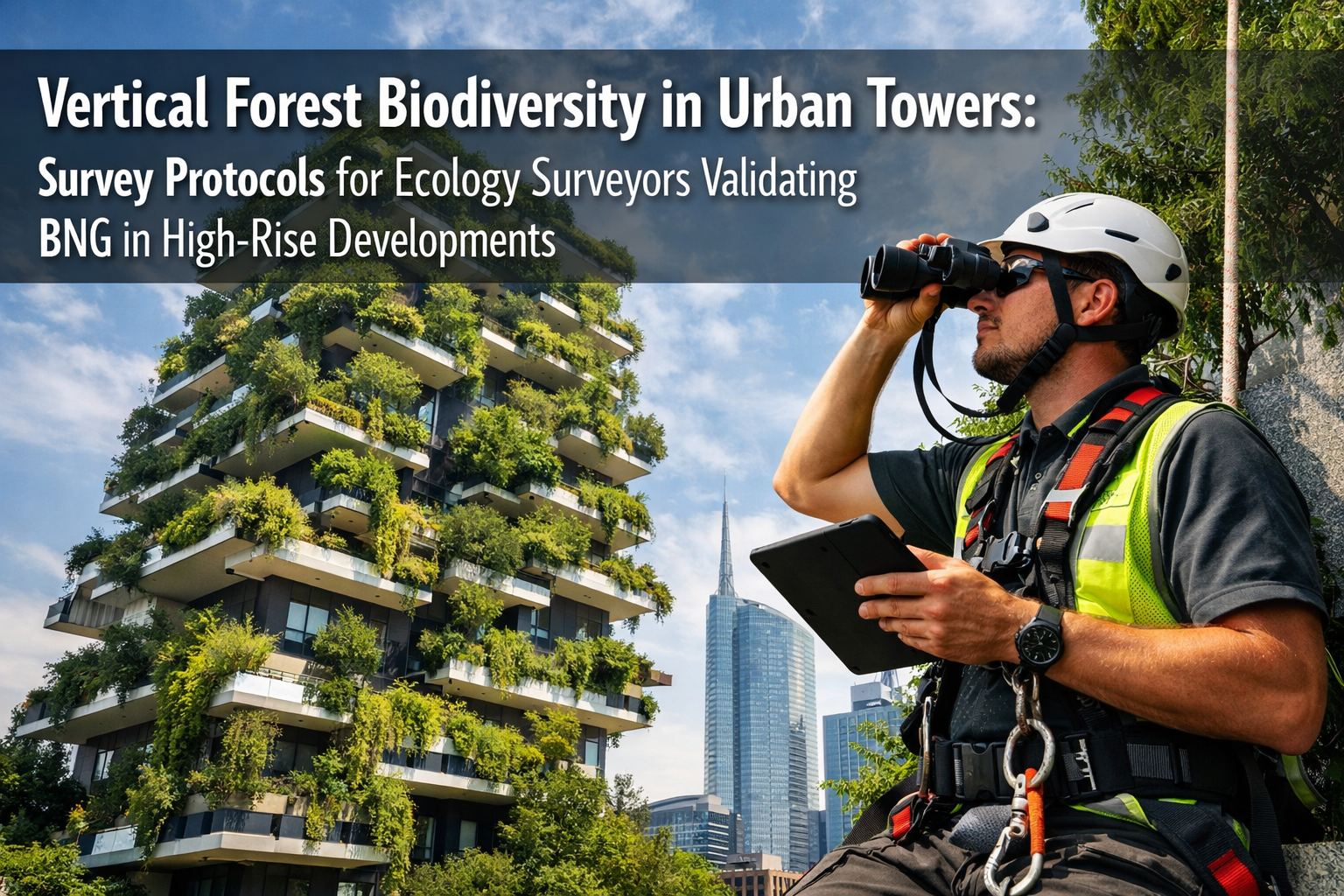
Vertical Forest Biodiversity in Urban Towers: Survey Protocols for Ecology Surveyors Validating BNG in High-Rise Developments represents a critical frontier in urban ecology. As developers increasingly integrate living vegetation into high-rise architecture, the need for standardized assessment methodologies has become urgent. This comprehensive guide explores field-tested survey techniques, remote sensing innovations, and validation frameworks that enable accurate BNG calculations for vertical greenery systems.
Key Takeaways
- Vertical forests create concentrated biodiversity hotspots, with projects like Bosco Verticale demonstrating habitat capacity for 1,600+ species on minimal urban footprints
- Specialized survey protocols combining traditional field methods with remote sensing technology are essential for accurate BNG validation in high-rise developments
- Plant-insect-microbe interactions in vertical systems differ significantly from ground-level habitats, requiring altitude-stratified sampling approaches
- 2026 megacity case studies provide scalable frameworks for implementing standardized vertical forest biodiversity assessments
- Multi-season monitoring programs capture temporal variation critical for robust BNG certification and long-term habitat quality verification
Understanding Vertical Forest Ecosystems and BNG Requirements 🌳
Vertical forest biodiversity operates under fundamentally different ecological principles than traditional ground-level habitats. The Bosco Verticale in Milan features 800 trees, 4,500 shrubs, and 15,000-20,000 plants from approximately 90-100 species distributed across two towers reaching 80 and 112 meters.[1][4] This vertical stratification creates distinct microhabitat zones, each with unique temperature, humidity, wind exposure, and light conditions.
Ecological Functions of Vertical Greenery Systems
The vegetation in vertical forests performs multiple ecosystem services simultaneously:
- Carbon sequestration: Absorbs CO₂ while producing oxygen throughout the building envelope
- Microclimate regulation: Reduces building energy consumption by approximately 7.5% through façade shading[5]
- Air quality improvement: Captures fine particulate matter and reduces urban pollution
- Noise attenuation: Vegetation layers absorb and deflect sound pollution
- Habitat provision: Creates nesting sites, foraging areas, and movement corridors for urban wildlife
For achieving Biodiversity Net Gain without the risk, understanding these multifunctional benefits is essential. However, quantifying them requires survey protocols that extend beyond traditional habitat assessment methodologies.
BNG Calculation Challenges in Vertical Systems
Standard BNG metrics were developed primarily for horizontal landscapes. Applying these frameworks to vertical forests presents several complications:
Habitat Area Calculations: Should vertical surface area be counted at full value, or adjusted based on substrate depth and structural constraints?
Distinctiveness Ratings: How do elevated planted containers compare to ground-level woodland or scrub habitats in the UK Habitat Classification system?
Condition Assessments: Traditional condition criteria (e.g., ground layer vegetation diversity, dead wood presence) may not translate directly to containerized vertical plantings.
Connectivity Scoring: Vertical habitats create three-dimensional connectivity networks that standard two-dimensional mapping tools cannot adequately capture.
Ecology surveyors must adapt biodiversity impact assessment methodologies to address these unique characteristics while maintaining consistency with statutory BNG requirements.
Field Survey Protocols for Vertical Forest Biodiversity Assessment 📋
Effective Vertical Forest Biodiversity in Urban Towers: Survey Protocols for Ecology Surveyors Validating BNG in High-Rise Developments require integration of traditional ecological survey techniques with specialized access and safety considerations.
Pre-Survey Planning and Safety Protocols
Before conducting any vertical forest assessment, surveyors must complete comprehensive safety planning:
✅ Access Assessment: Coordinate with building management for balcony access, rope access certification requirements, or mobile elevated work platform (MEWP) deployment
✅ Personal Protective Equipment (PPE): Hard hats, safety harnesses, high-visibility clothing, and appropriate footwear for elevated work environments
✅ Weather Monitoring: Wind speed limits (typically <20 mph for elevated surveys), precipitation forecasts, and temperature extremes
✅ Emergency Procedures: Evacuation routes, first aid provisions, and communication protocols with ground support teams
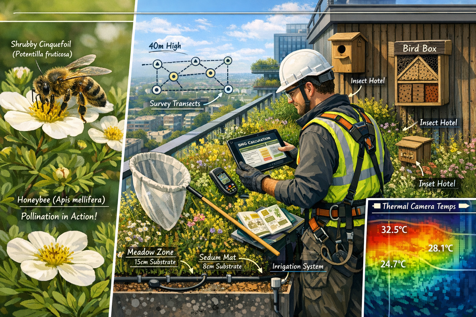
Altitude-Stratified Vegetation Sampling
Vertical forests exhibit distinct vegetation zones based on height above ground level. Survey protocols should establish stratified sampling units at regular intervals:
Ground Level (0-10m): Typically features shade-tolerant species, higher moisture retention, reduced wind exposure
Mid-Level (10-40m): Transitional zone with moderate light, intermediate wind exposure, variable microclimate conditions
Upper Level (40m+): Full sun exposure, increased wind stress, lower humidity, temperature extremes
For each stratum, surveyors should record:
- Plant species composition and abundance
- Vegetation structure (canopy layers, stem density, foliage coverage)
- Substrate depth and composition
- Irrigation system functionality
- Evidence of plant stress or mortality
- Presence of invasive species
The Bosco Verticale demonstrates strategic plant selection principles, with 59 of 94 species specifically chosen to attract birds, and placement determined by solar exposure, altitude, microclimate, and flowering seasons.[1][2] Survey protocols should document whether similar ecological design principles have been implemented and are functioning as intended.
Fauna Survey Methodologies
Assessing wildlife utilization of vertical forests requires adapted survey techniques:
Bird Surveys: Conduct point counts at multiple building levels during dawn chorus periods (April-June in temperate regions). Record species, abundance, breeding evidence (nesting materials, territorial behavior), and foraging activity. Install nest boxes with monitoring cameras to document occupancy rates.
Invertebrate Sampling: Deploy pan traps, pitfall traps, and sweep netting at different elevations. Focus on pollinator activity during flowering periods. Install malaise traps on accessible balconies for flying insect diversity assessment.
Bat Activity Monitoring: Use static acoustic detectors placed at various heights to record echolocation calls. Vertical structures may serve as commuting routes or foraging habitats for aerial insectivores.
Microhabitat Features: Document presence of dead wood, leaf litter accumulation, water features, and artificial habitat structures (insect hotels, hibernacula) that enhance biodiversity value.
Plant-Insect-Microbe Interaction Assessment
Understanding trophic relationships is critical for validating long-term habitat functionality. Survey protocols should include:
Pollination Observations: Timed watches recording flower-visiting insects, identifying both plant and pollinator species, and quantifying visitation rates
Herbivory Evidence: Leaf damage assessments indicating presence of herbivorous insects and functional food web establishment
Soil Microbiome Sampling: Collect substrate samples from different elevations and vegetation types for microbial community analysis (bacterial and fungal diversity)
Mycorrhizal Associations: Document presence of beneficial fungal partnerships that enhance plant nutrient uptake and stress tolerance
These interaction assessments provide evidence that vertical forest ecosystems support complex ecological communities rather than functioning merely as ornamental plantings.
Temporal Monitoring Requirements
Single-visit surveys provide insufficient data for robust BNG validation. Comprehensive protocols require multi-season monitoring:
| Season | Survey Focus | Key Indicators |
|---|---|---|
| Spring | Breeding bird activity, flowering phenology, pollinator emergence | Nest site utilization, plant-pollinator networks |
| Summer | Peak vegetation growth, invertebrate diversity, microclimate benefits | Canopy coverage, species richness, temperature regulation |
| Autumn | Fruit/seed production, migratory bird usage, plant senescence | Food resource availability, habitat connectivity |
| Winter | Evergreen structure, roosting sites, substrate condition | Shelter provision, maintenance requirements |
This temporal approach captures seasonal variation essential for calculating annual biodiversity unit values and ensuring 10% Biodiversity Net Gain targets are genuinely achieved.
Remote Sensing and Technology-Enhanced Survey Methods 🛰️
Vertical Forest Biodiversity in Urban Towers: Survey Protocols for Ecology Surveyors Validating BNG in High-Rise Developments increasingly incorporate advanced technology to overcome access limitations and enhance data quality.
Drone-Based Multispectral Imaging
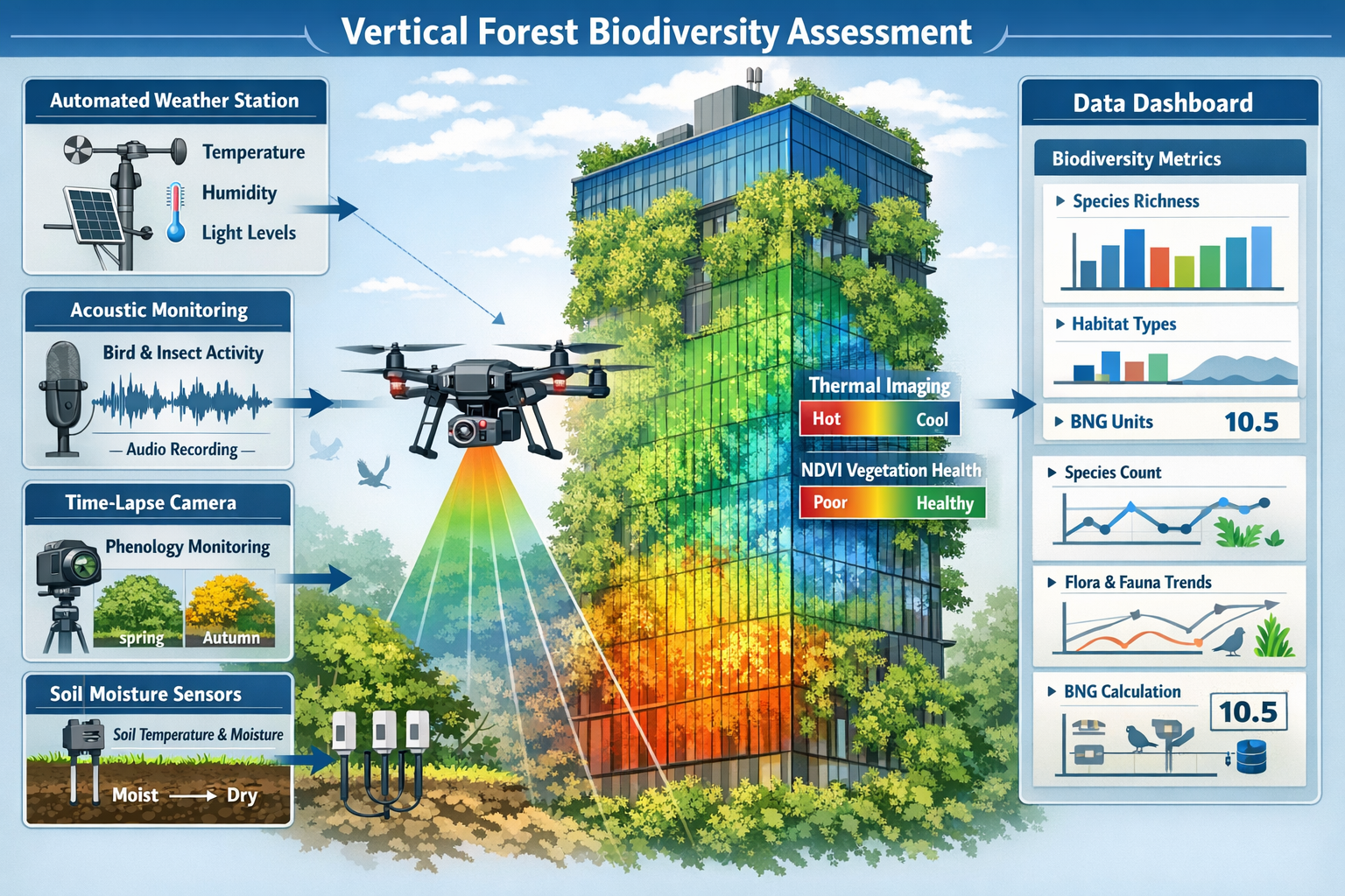
Unmanned aerial vehicles (UAVs) equipped with multispectral cameras provide non-invasive vegetation health assessment:
Normalized Difference Vegetation Index (NDVI): Quantifies photosynthetic activity and plant vigor across entire building facades
Thermal Imaging: Maps temperature gradients demonstrating microclimate regulation benefits
3D Photogrammetry: Creates detailed structural models for accurate vegetation volume calculations
Temporal Change Detection: Compares imagery across seasons and years to document establishment success and habitat maturation
Drone surveys enable comprehensive coverage of inaccessible areas while minimizing safety risks and access costs. However, surveyors must obtain appropriate aviation permissions and coordinate with building occupants regarding privacy considerations.
Automated Acoustic Monitoring
Acoustic recording units deployed at multiple elevations capture continuous wildlife activity data:
- 24/7 monitoring eliminates temporal sampling bias inherent in human-conducted surveys
- Species identification algorithms process thousands of hours of recordings to detect bird calls, bat echolocation, and insect sounds
- Activity pattern analysis reveals how wildlife utilizes vertical habitats across diel and seasonal cycles
- Long-term datasets document biodiversity trends and habitat quality changes over years
Acoustic data provides objective evidence of fauna utilization that strengthens BNG validation documentation.
Environmental Sensor Networks
Internet-of-Things (IoT) sensor arrays embedded within vertical forest infrastructure monitor critical ecological parameters:
Microclimate Sensors: Temperature, humidity, light intensity, wind speed at multiple elevations
Soil Moisture Probes: Substrate water content ensuring irrigation systems maintain appropriate conditions
Air Quality Monitors: Particulate matter capture and pollutant reduction quantification
Growth Monitoring: Dendrometer bands measuring tree diameter increment as proxy for carbon sequestration
These continuous datasets demonstrate ecosystem function performance and identify maintenance issues before they compromise biodiversity outcomes.
Machine Learning-Enhanced Species Identification
Computer vision and artificial intelligence tools accelerate data processing:
- Automated plant identification from photographs enables rapid species inventory compilation
- Insect image recognition processes pan trap and camera trap imagery to quantify diversity
- Anomaly detection algorithms flag plant health issues or invasive species establishment
- Predictive modeling forecasts habitat quality trajectories under different management scenarios
While technology enhances efficiency, experienced ecology surveyors remain essential for ground-truthing automated identifications and interpreting ecological significance.
Case Studies: 2026 Megacity Vertical Forest BNG Validation 🌍
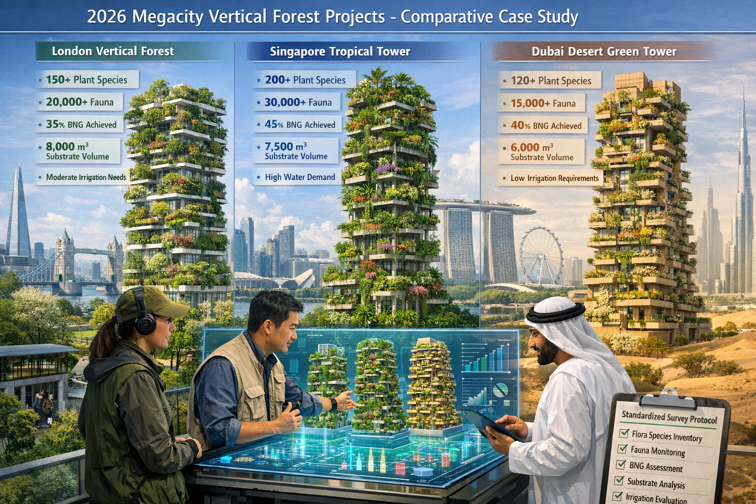
Recent vertical forest developments across global megacities demonstrate scalable approaches to Vertical Forest Biodiversity in Urban Towers: Survey Protocols for Ecology Surveyors Validating BNG in High-Rise Developments.
London Canary Wharf Biodiversity Tower
Project Specifications: 45-story residential tower with 12,000 plants representing 40 native UK species across 280 balconies
Survey Protocol Implementation:
- Quarterly field surveys conducted by rope-access certified ecologists
- Drone NDVI mapping every six weeks during growing season
- Acoustic monitoring units on floors 5, 15, 25, 35, and 45
- Citizen science component with resident-submitted wildlife observations via mobile app
BNG Outcomes:
- Achieved 18% net gain through on-site habitat creation
- Documented 23 bird species utilizing vertical habitats (including breeding house martins)
- Pollinator surveys recorded 47 invertebrate species including 12 bee species
- Microclimate monitoring demonstrated 6.2°C temperature reduction on south-facing facades during summer months
Key Success Factors: Architects solved BNG requirements through early integration of ecology expertise, generous substrate depths (minimum 45cm), and native species prioritization aligned with local biodiversity action plan targets.
Singapore Marina Bay Tropical Sky Forest
Project Specifications: Twin 60-story towers with 18,000 plants from 85 tropical species, including epiphytic orchids, ferns, and canopy trees
Survey Protocol Implementation:
- Monthly vegetation health assessments using building maintenance unit (BMU) access
- Thermal imaging surveys quantifying cooling benefits
- Butterfly and moth monitoring using UV light traps at multiple elevations
- Mycorrhizal sampling documenting fungal diversity in substrate
BNG Equivalent Outcomes (adapted to Singapore Green Mark framework):
- Created habitat supporting 34 butterfly species (8 previously unrecorded in urban core)
- Documented successful establishment of epiphytic plant communities mimicking natural forest structure
- Microbiome analysis revealed substrate fungal diversity comparable to urban park soils
- Energy modeling confirmed 8.3% cooling load reduction attributable to vegetation
Key Success Factors: Climate-appropriate species selection, automated irrigation with nutrient injection systems, and integration with broader urban ecological network planning.
Dubai Desert-Adapted Vertical Oasis
Project Specifications: 38-story mixed-use tower with 6,500 drought-tolerant plants from 52 species, including native desert flora and Mediterranean climate analogs
Survey Protocol Implementation:
- Bi-monthly surveys during cooler months (October-April)
- Substrate moisture and salinity monitoring to prevent irrigation-related soil degradation
- Bird migration monitoring during spring and autumn passage periods
- Heat stress assessment using thermal cameras during summer extremes
BNG Equivalent Outcomes (adapted to regional environmental assessment frameworks):
- Provided stopover habitat for 18 migratory bird species during passage periods
- Supported resident populations of sunbirds and bulbuls
- Demonstrated 40% reduction in irrigation requirements compared to initial projections through adaptive species selection
- Created microrefugia with temperatures 11°C cooler than surrounding urban surfaces
Key Success Factors: Extreme climate adaptation through species trials, phased planting approach allowing iterative refinement, and integration of greywater recycling systems.
Comparative Analysis: Scalable Survey Protocol Elements
Across these diverse 2026 megacity projects, several survey protocol elements proved universally applicable:
✅ Multi-elevation sampling capturing vertical habitat gradients
✅ Technology integration combining field surveys with remote sensing for comprehensive coverage
✅ Temporal monitoring documenting seasonal and annual trends
✅ Functional assessment measuring ecosystem services alongside species inventories
✅ Adaptive management feedback loops using survey data to refine maintenance and enhance biodiversity outcomes
These case studies demonstrate that biodiversity net gain for small development projects and large-scale urban towers alike can achieve meaningful ecological outcomes when supported by rigorous survey protocols.
Validation Frameworks and BNG Certification Documentation 📊
Translating vertical forest survey data into statutory BNG compliance requires careful application of validation frameworks.
Habitat Classification and Distinctiveness Assignment
Vertical forest habitats do not fit neatly into existing UK Habitat Classification categories. Surveyors must justify classification decisions:
Potential Classifications:
- Urban trees (distinctiveness: medium) – for individual tree specimens in large containers
- Introduced shrub (distinctiveness: low) – for ornamental shrub plantings
- Flower-rich margins and plots (distinctiveness: medium) – for herbaceous perennial plantings designed for pollinators
- Mixed scrub (distinctiveness: medium) – for diverse native shrub communities
Justification Requirements: Document species composition, structural complexity, management intensity, and ecological function to support classification decisions. Reference design intent and compare to ground-level habitat analogs.
Condition Assessment Adaptations
Standard condition assessment criteria require modification for vertical contexts:
Traditional Criteria → Vertical Forest Adaptations
- Ground layer diversity → Understory planting diversity within multi-layered containers
- Tree age structure → Size class distribution and maturity indicators
- Dead wood presence → Retained pruning materials and habitat features
- Scrub edge structure → Vegetation layering and structural heterogeneity
- Invasive species cover → Monitoring for wind-dispersed invasives and escaped ornamentals
Surveyors should develop vertical forest-specific condition scorecards that maintain assessment rigor while acknowledging structural differences from ground-level habitats.
Spatial Risk Multiplier Considerations
Vertical forests may qualify for reduced spatial risk multipliers due to:
- Secure long-term management: Building maintenance contracts ensure ongoing habitat stewardship
- Protection from ground-level disturbances: Elevated habitats buffered from human trampling, domestic pets, and urban development pressures
- Controlled environmental conditions: Irrigation systems and substrate management reduce climate-related establishment risks
However, surveyors must also consider elevated risks:
- Substrate depth limitations: Restricting root development and long-term tree establishment
- Microclimate extremes: Wind exposure and temperature fluctuations at height
- Maintenance dependency: Irrigation system failures could cause rapid habitat degradation
Biodiversity Net Gain assessment documentation should transparently address both risk mitigation factors and vulnerability considerations specific to vertical systems.
Temporal Multiplier Application
Vertical forests typically achieve rapid habitat establishment compared to ground-level woodland creation, potentially justifying reduced temporal multipliers. However, long-term habitat maturity and self-sustainability remain uncertain for many vertical systems.
Conservative Approach: Apply standard temporal multipliers until multi-decade monitoring data demonstrates vertical forest longevity and ecological maturity comparable to traditional habitats.
Evidence-Based Adjustment: Projects with >10 years of monitoring data (e.g., Bosco Verticale, now over a decade old) demonstrating sustained biodiversity support may justify temporal multiplier reductions.
Off-Site vs. On-Site Delivery Considerations
Vertical forests represent innovative on-site BNG delivery mechanisms for urban developments with limited ground-level space. However, they should not entirely replace ground-level habitat creation where feasible.
Optimal Approach: Integrate vertical forests as complementary on-site enhancement alongside ground-level habitat creation, green roofs, and off-site habitat banking where necessary to achieve 10% net gain targets.
Implementation Challenges and Solutions 🔧
Access and Safety Constraints
Challenge: Conducting thorough surveys on high-rise buildings requires specialized access equipment and safety certification.
Solution: Partner with rope access technicians holding IRATA or equivalent certification. Schedule surveys during building maintenance access windows. Utilize remote sensing to supplement rather than replace field surveys where access is prohibitively difficult or expensive.
Seasonal Weather Limitations
Challenge: Wind, precipitation, and temperature extremes restrict safe survey periods at elevation.
Solution: Establish flexible survey scheduling with backup dates. Deploy automated monitoring equipment for continuous data collection during periods when human access is unsafe. Focus intensive field surveys during optimal weather windows.
Data Standardization Across Projects
Challenge: Lack of standardized vertical forest survey protocols creates inconsistency in BNG validation approaches.
Solution: Industry working groups should develop vertical greenery survey standards analogous to existing habitat survey methodologies. Professional bodies (CIEEM, IEMA) should provide technical guidance and training programs for ecology surveyors specializing in vertical forest assessment.
Long-Term Monitoring Funding
Challenge: BNG requires 30-year habitat management and monitoring, but funding mechanisms for vertical forest monitoring remain underdeveloped.
Solution: Establish monitoring endowments as condition of planning permission. Integrate monitoring costs into building service charges. Explore biodiversity unit and statutory credit markets to fund long-term stewardship.
Substrate and Irrigation System Maintenance
Challenge: Vertical forest biodiversity depends entirely on functioning irrigation and substrate quality, creating maintenance dependencies not present in ground-level habitats.
Solution: Implement redundant irrigation systems with automated monitoring and alerts. Specify high-quality substrate mixes with slow-release nutrients. Include substrate replacement schedules in long-term management plans. Train building maintenance staff in ecological maintenance principles.
Professional Development for Vertical Forest Surveyors 🎓
As vertical forest developments proliferate, ecology professionals require specialized skills:
Essential Competencies:
- Working at height safety certification (rope access or MEWP operation)
- Remote sensing and GIS analysis for drone-derived data interpretation
- Horticultural knowledge for containerized plant assessment
- Building systems understanding (irrigation, drainage, structural loading)
- Urban ecology and novel ecosystem assessment frameworks
Recommended Training Pathways:
- IRATA Level 1 rope access certification for direct habitat access
- CAA drone pilot certification for UAV survey operations
- Continuing professional development courses on green infrastructure ecology
- Cross-disciplinary collaboration with landscape architects, engineers, and building managers
The benefits of working with biodiversity surveyors extend beyond statutory compliance to creating genuinely functional urban ecosystems that support wildlife and human wellbeing.
Conclusion
Vertical Forest Biodiversity in Urban Towers: Survey Protocols for Ecology Surveyors Validating BNG in High-Rise Developments represents an essential evolution in urban ecology practice. As cities worldwide embrace vertical greenery as a solution to biodiversity loss and climate adaptation challenges, robust survey methodologies ensure these innovations deliver measurable ecological benefits rather than functioning merely as architectural greenwashing.
The integration of traditional field survey techniques with remote sensing technology, automated monitoring systems, and multi-season assessment programs enables comprehensive biodiversity validation even in challenging high-rise environments. Case studies from 2026 megacity projects demonstrate that vertical forests can achieve genuine net gain outcomes, supporting diverse wildlife communities while providing critical ecosystem services in dense urban contexts.
Actionable Next Steps
For developers and architects planning vertical forest projects:
- Engage ecology surveyors during early design stages to optimize habitat creation potential
- Allocate sufficient budget for comprehensive baseline surveys and long-term monitoring programs
- Specify generous substrate depths, native species prioritization, and robust irrigation systems
- Review guidance for developers to understand BNG requirements
For ecology surveyors expanding into vertical forest assessment:
- Pursue working-at-height safety certifications to enable direct habitat access
- Develop proficiency with remote sensing tools and automated monitoring technologies
- Build collaborative relationships with building managers and maintenance teams
- Contribute to emerging professional standards for vertical greenery survey protocols
For planning authorities evaluating vertical forest BNG proposals:
- Require detailed survey protocols demonstrating multi-season, multi-elevation assessment approaches
- Request evidence of long-term monitoring funding and maintenance commitments
- Evaluate habitat classifications and condition assessments with appropriate skepticism, requiring robust justification
- Consider vertical forests as complementary to rather than replacement for ground-level habitat creation
The vertical forest movement offers tremendous potential for urban biodiversity recovery, but realizing this potential demands rigorous ecological assessment. By implementing comprehensive survey protocols and validation frameworks, ecology surveyors ensure that these striking architectural features function as genuine biodiversity assets, contributing meaningfully to nature recovery in our increasingly urbanized world.
References
[1] Milans Vertical Forest Pioneering Architectural Biodiversity And Urban Nature Integration – https://esop.ro/blog/en/milans-vertical-forest-pioneering-architectural-biodiversity-and-urban-nature-integration/
[2] Milans Vertical Forest By Stefano Boeri Architetti Rethinking Urban Living – https://archeyes.com/milans-vertical-forest-by-stefano-boeri-architetti-rethinking-urban-living/
[4] Vertical Forest – https://www.stefanoboeriarchitetti.net/en/project/vertical-forest/
[5] Milan Italy Bosco Verticale – https://aiph.org/green-city-case-studies/milan-italy-bosco-verticale/
