
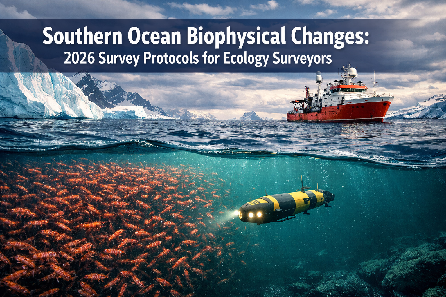
The Southern Ocean is experiencing unprecedented transformation. As ice shelves retreat and ocean temperatures rise, the delicate balance of Antarctic food webs hangs in the balance. For ecology surveyors tasked with monitoring these changes in 2026, the challenge is clear: how do we accurately track ecosystem shifts in one of Earth's most remote and dynamic environments?
Southern Ocean Biophysical Changes: 2026 Survey Protocols for Ecology Surveyors Tracking Polar Ecosystem Shifts represents a critical framework for understanding and documenting the rapid transformations occurring in polar waters. Drawing from the latest international research initiatives and technological advances, these protocols provide field-ready methodologies that combine cutting-edge remote sensing with traditional on-site sampling techniques. The stakes couldn't be higher—krill populations, the foundation of Antarctic food webs, are showing signs of stress, while marine heat waves and ocean acidification threaten the entire ecosystem.
Key Takeaways
- 🌊 Integrated monitoring approaches combining autonomous platforms, satellite data, and field sampling are essential for tracking rapid Southern Ocean ecosystem changes in 2026
- 📊 Over 120,000 daily observations from mature biogeochemical networks now provide foundational data for detecting ecosystem state shifts and early warning system development
- 🔬 New survey protocols emphasize cross-disciplinary integration of physics, biogeochemistry, and biology to assess impacts on krill populations and Antarctic food webs
- 🛰️ Advanced remote sensing missions (PACE, SWOT) combined with AI-driven algorithms enable monitoring in previously inaccessible marginal ice zones during winter months
- ⚠️ Critical data gaps remain in subsurface processes and winter observations, requiring surveyors to prioritize strategic sampling locations for maximum ecosystem insight
Understanding Southern Ocean Biophysical Changes in 2026
The Southern Ocean encircles Antarctica like a massive conveyor belt, driving global climate patterns and supporting unique marine ecosystems. In 2026, this vital region faces accelerating changes that demand urgent attention from ecology surveyors and conservation professionals.
The Current State of Southern Ocean Ecosystems
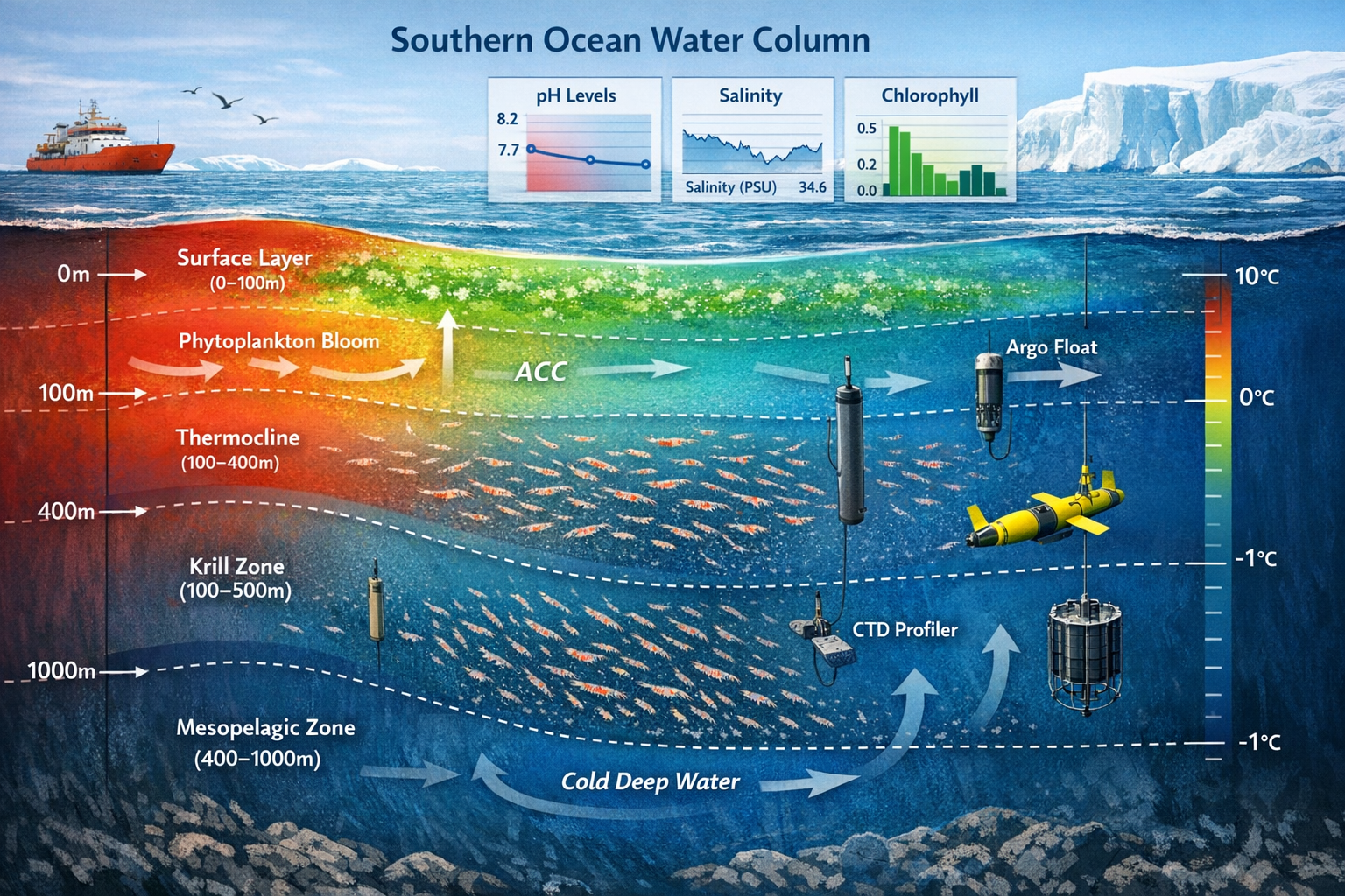
Biophysical changes in the Southern Ocean encompass multiple interconnected processes. Ocean temperatures have risen measurably over recent decades, while sea-ice extent shows dramatic seasonal variability. These physical changes cascade through the ecosystem, affecting everything from microscopic phytoplankton to massive whale populations.
The Antarctic Circumpolar Current (ACC), the world's largest ocean current, plays a crucial role in nutrient distribution and heat transport. Changes in ACC dynamics directly influence primary productivity—the foundation of the entire food web. When upwelling patterns shift, nutrient-rich deep waters may fail to reach surface layers where phytoplankton grow, creating ripple effects throughout the ecosystem.
Krill populations serve as the critical link between primary producers and higher trophic levels. These small crustaceans support penguins, seals, whales, and numerous fish species. Recent surveys indicate concerning shifts in krill distribution patterns, with populations moving southward as their preferred habitat changes. For ecology surveyors, accurately tracking these population dynamics is essential for understanding broader ecosystem health.
Key Drivers of Ecosystem Change
Several major factors are driving Southern Ocean transformations:
- Ocean acidification: Increased atmospheric CO₂ absorption lowers ocean pH, affecting calcifying organisms and disrupting food web dynamics
- Marine heat waves: Temporary temperature spikes can trigger rapid ecosystem responses and species distribution shifts
- Sea-ice loss: Reduced ice coverage affects krill breeding habitat and alters predator-prey relationships
- Freshwater input: Accelerated ice shelf melting changes salinity patterns and stratification
- Nutrient cycling changes: Altered mixing patterns affect the supply of essential nutrients like iron and nitrogen
The Global Ocean Observing System (GOOS) and International Ocean Carbon Coordination Partnership (IOCCP) have announced plans beginning in 2026 to optimize the design of the entire biogeochemical observing system, with emphasis on cross-disciplinary integration across multiple observing networks [2]. This collaborative approach recognizes that understanding ecosystem changes requires simultaneous monitoring of physical, chemical, and biological parameters.
Similar to how biodiversity surveyors benefit both nature and developers in terrestrial environments, Southern Ocean ecology surveyors must balance scientific rigor with practical conservation outcomes.
Southern Ocean Biophysical Changes: 2026 Survey Protocols and Methodologies
Effective monitoring of Southern Ocean ecosystem shifts requires robust, standardized protocols that can be implemented across diverse research platforms and challenging environmental conditions. The 2026 survey protocols represent an evolution in ecological monitoring, integrating traditional field methods with emerging technologies.
Core Protocol Components for Ecology Surveyors
Physical oceanography measurements form the foundation of any comprehensive survey. Surveyors must collect:
- Temperature and salinity profiles: Using CTD (Conductivity-Temperature-Depth) sensors deployed from research vessels or autonomous platforms
- Current velocity data: Acoustic Doppler Current Profilers (ADCP) measure water movement at multiple depths
- Sea-ice observations: Visual assessments, ice thickness measurements, and ice core sampling for biological analysis
- Mixed layer depth: Critical for understanding nutrient availability and primary production zones
Biogeochemical sampling protocols capture the chemical environment that shapes ecosystem function:
- Dissolved oxygen: Indicates biological activity and water mass characteristics
- Nutrient concentrations: Nitrate, phosphate, silicate, and iron measurements reveal productivity limitations
- pH and carbonate chemistry: Essential for tracking ocean acidification impacts
- Dissolved organic matter: Influences carbon cycling and food web dynamics
- Chlorophyll-a concentration: Direct indicator of phytoplankton biomass
The Surface Ocean CO₂ Reference Network (SOCONET) now uses multiple observing platforms to expand high-quality surface water CO₂ measurements, supporting assessment of ocean health and carbon cycling roles in the Southern Ocean [2]. Ecology surveyors should align their sampling protocols with SOCONET standards to ensure data compatibility and maximum utility.
Biological Sampling Strategies
Plankton surveys require specialized equipment and careful timing:
- Net tows: Multiple mesh sizes (20μm to 1000μm) capture different size classes from microplankton to mesozooplankton
- Continuous Plankton Recorder (CPR): Provides standardized sampling along transect lines
- Acoustic surveys: Multi-frequency echosounders detect krill swarms and estimate biomass
- Optical imaging systems: Capture high-resolution images of plankton communities for species identification
Krill-specific protocols deserve special attention given their ecosystem importance:
- Targeted net sampling in known aggregation zones
- Length-frequency measurements for population structure analysis
- Maturity staging to assess reproductive success
- Gut content analysis to understand feeding ecology
- Genetic sampling for population connectivity studies
The International Ocean Colour Coordinating Group (IOCCG) maintains revised protocols for in situ optical and biogeochemical measurements critical for validating satellite ocean colour data, including dissolved organic matter and primary productivity measurements relevant to ecosystem assessments [4]. These validation protocols ensure that remote sensing data accurately reflects on-water conditions.
Integrating Remote Sensing with Field Observations
Satellite data integration multiplies the value of field surveys exponentially. Recent advances in autonomous marine and aerial vehicles, combined with next-generation remote sensing missions (PACE, SWOT, GOES) and AI-driven algorithms, are enabling observations in challenging environments including marginal ice zones [3].
Key remote sensing products for ecology surveyors:
| Parameter | Satellite Mission | Resolution | Application |
|---|---|---|---|
| Ocean color (chlorophyll) | PACE, Sentinel-3 | 300m-1km | Phytoplankton biomass |
| Sea surface temperature | MODIS, VIIRS | 1km | Thermal habitat mapping |
| Sea-ice extent/concentration | AMSR2, Sentinel-1 | 3-25km | Krill habitat availability |
| Sea surface height | SWOT | 15km | Current patterns, eddies |
| Ocean winds | ASCAT | 25km | Mixing, upwelling zones |
Protocol for integrated surveys:
- Pre-survey planning: Download recent satellite imagery to identify oceanographic features (fronts, eddies, ice edges)
- Adaptive sampling: Adjust survey tracks based on real-time satellite data to target dynamic features
- Ground-truthing: Collect in situ measurements at locations coinciding with satellite overpasses
- Data synthesis: Combine field data with satellite products to create comprehensive ecosystem assessments
- Validation: Compare satellite-derived parameters with direct measurements to quantify accuracy
The Southern Ocean Observing System (SOOS) has identified developing early warning systems to monitor, predict, and assess consequences of state shifts (sea-ice extent changes, marine heat waves) and slower changes (ocean acidification) as a specific five-year priority [3]. Ecology surveyors should structure their protocols to contribute to these early warning system development efforts.
Just as conducting biodiversity impact assessments requires systematic methodology in terrestrial environments, Southern Ocean surveys demand rigorous, repeatable protocols that generate comparable data across time and space.
Implementing 2026 Survey Protocols for Tracking Polar Ecosystem Shifts

Moving from protocol design to field implementation presents unique challenges in the Southern Ocean environment. Successful surveys require careful planning, appropriate technology deployment, and robust data management systems.
Autonomous Platform Deployment Strategies
Autonomous platforms have revolutionized Southern Ocean monitoring by providing year-round data collection in regions too dangerous or expensive for crewed vessels. In 2026, ecology surveyors have access to several platform types:
Argo floats equipped with biogeochemical sensors (BGC-Argo) measure temperature, salinity, oxygen, pH, nitrate, chlorophyll, and backscatter as they drift with currents and cycle between surface and 2000m depth. Deployment strategies should:
- Target regions with known data gaps (Weddell Sea, Ross Sea sectors)
- Deploy in arrays to capture spatial variability
- Coordinate with international programs to maximize coverage
- Plan for 3-5 year operational lifespans
Autonomous underwater vehicles (AUVs) provide high-resolution surveys of specific features:
- Under-ice missions to study ice-ocean interface biology
- Eddy characterization surveys
- Seamount and canyon ecosystem mapping
- Validation transects for satellite data
Wave gliders and surface drones excel at long-duration surface measurements:
- Continuous surface CO₂ monitoring along extended transects
- Ocean color validation data collection
- Marine mammal acoustic monitoring
- Real-time data transmission for adaptive sampling
Mature biogeochemical networks are currently collecting over 120,000 observations per day, providing foundation data for ecosystem monitoring and state-shift detection [2]. Ecology surveyors should leverage these existing data streams while identifying strategic gaps their surveys can fill.
Addressing Critical Data Gaps
Despite increased Southern Ocean observations over the past decade, observational data remains sparse relative to the region's size, with particular data gaps in subsurface processes and winter observations [3]. The 2026 survey protocols specifically address these limitations:
Winter observation priorities:
- ✅ Deploy autonomous platforms before winter ice formation
- ✅ Utilize ice-capable AUVs for under-ice surveys
- ✅ Establish overwinter monitoring stations on fast ice
- ✅ Maximize satellite remote sensing during periods of vessel inaccessibility
- ✅ Collaborate with research stations for shore-based observations
Subsurface process monitoring:
- Deep-diving gliders to capture mesopelagic zone dynamics
- Sediment trap deployments to quantify carbon export
- Moored profilers for continuous water column measurements
- Deep-ocean camera systems to observe benthic-pelagic coupling
Marginal ice zone (MIZ) surveys:
The MIZ represents a critical ecotone where ice-ocean interactions drive high biological productivity. Autonomous marine and aerial vehicles combined with next-generation remote sensing enable observations in these challenging environments [3]. Survey protocols should include:
- Coordinated drone flights for ice characterization
- Under-ice AUV transects measuring ice thickness and biology
- Ship-based sampling at ice edge during seasonal transitions
- Satellite tracking of MIZ position and productivity
Data Management and Quality Control
FAIR principles (Findable, Accessible, Interoperable, Reusable) must guide all data management efforts. The collaborative data platform SOOSmap, developed by SOOS and the European Marine Observations and Data Network, hosts over 50,000 physical, biogeochemical, and ecological observations, implementing FAIR principles and open access to support ecosystem science [3].
Essential data management steps:
- Standardized metadata: Document all sampling methods, equipment calibrations, and environmental conditions
- Quality control flags: Apply standardized QC procedures following international protocols
- Timely submission: Upload data to recognized repositories within 6-12 months of collection
- Version control: Maintain clear records of data processing and corrections
- Open access: Make data publicly available unless justified restrictions apply
Recommended data repositories:
- SOOS SOOSmap: Primary platform for Southern Ocean integrated data
- OBIS (Ocean Biodiversity Information System): Species occurrence and biodiversity data
- PANGAEA: Comprehensive earth and environmental science data
- BCO-DMO (Biological and Chemical Oceanography Data Management Office): Process-oriented oceanographic data
Ecosystem Net Gain Assessment Framework
Applying biodiversity net gain concepts to Southern Ocean ecosystems requires adapted methodologies. While traditional biodiversity net gain approaches focus on terrestrial habitats, the principles translate to marine environments with modifications:
Baseline ecosystem characterization:
- Establish reference conditions using historical data and current surveys
- Quantify ecosystem components: primary productivity, krill biomass, predator populations
- Map critical habitats: polynya systems, upwelling zones, ice-edge productivity areas
- Document ecosystem services: carbon sequestration, fisheries support, climate regulation
Impact assessment:
- Identify anthropogenic pressures: fishing, research activities, climate change effects
- Quantify ecosystem changes using standardized metrics
- Project future trajectories under different scenarios
- Assess cumulative impacts across multiple stressors
Conservation and restoration actions:
- Establish marine protected areas in critical habitats
- Implement ecosystem-based fisheries management
- Monitor recovery in protected zones
- Support climate mitigation to address root causes
The upcoming Antarctic and Southern Ocean Research Plan workshop on March 24-25, 2026, hosted by South Africa's National Antarctic Programme, will address research priorities including ecosystem monitoring approaches [1]. Ecology surveyors should engage with these international planning efforts to align their protocols with broader research priorities.
Similar to how landowners receive guidance on biodiversity enhancement, research organizations and fishing operators need clear frameworks for minimizing ecosystem impacts and supporting conservation goals in Southern Ocean waters.
Practical Field Considerations for 2026 Surveys
Safety protocols remain paramount in the harsh Southern Ocean environment:
- Comprehensive risk assessments for all field activities
- Appropriate cold-weather gear and survival equipment
- Communication systems with redundancy
- Emergency response plans for equipment failure or medical situations
- Environmental monitoring for sudden weather changes
Logistical planning essentials:
- Secure vessel time 12-18 months in advance
- Coordinate with international research programs for shared logistics
- Plan equipment shipping to remote ports with extended lead times
- Arrange permits for sampling in national jurisdictions and protected areas
- Budget adequately for Antarctic operations (typically 3-5x higher than temperate regions)
Equipment calibration and maintenance:
- Pre-deployment calibration of all sensors using certified standards
- Regular in-field calibration checks
- Backup equipment for critical measurements
- Detailed maintenance logs
- Post-deployment calibration verification
Collaboration opportunities:
Joining established research programs maximizes efficiency and impact. Consider partnerships with:
- National Antarctic programs (SANAP, AAD, NSF, etc.)
- International initiatives (SOOS, ICED, MEASO)
- Fishing industry observer programs
- Tourism vessel platforms of opportunity
- Other biodiversity surveying organizations expanding into marine environments
Technology Integration and AI Applications
Artificial intelligence is transforming how ecology surveyors process and interpret massive datasets. AI-driven algorithms enable:
- Automated species identification: Machine learning models classify plankton images with >90% accuracy
- Anomaly detection: AI flags unusual patterns in sensor data streams for rapid investigation
- Predictive modeling: Neural networks forecast ecosystem responses to environmental changes
- Data gap filling: Statistical models interpolate between sparse observations
- Multi-sensor fusion: AI integrates diverse data types into unified ecosystem assessments
Practical AI implementation:
- Start with pre-trained models adapted to Southern Ocean conditions
- Collect training datasets during field surveys
- Validate AI outputs against expert identifications
- Continuously improve models with new data
- Share trained models with research community
The integration of autonomous platforms with AI-driven algorithms enables observations in challenging environments including marginal ice zones, with applications for monitoring submesoscale physics and nutrient supply linkages [3]. This technological synergy represents a paradigm shift in our ability to monitor polar ecosystem changes.
Conclusion
The Southern Ocean stands at a critical juncture. Accelerating biophysical changes threaten to fundamentally alter Antarctic ecosystems, with cascading effects on global climate, biodiversity, and ocean health. Southern Ocean Biophysical Changes: 2026 Survey Protocols for Ecology Surveyors Tracking Polar Ecosystem Shifts provides the methodological framework needed to document, understand, and respond to these transformations.
The protocols outlined in this article emphasize integration—combining autonomous platforms with crewed surveys, merging remote sensing with in situ sampling, and linking physical measurements with biological observations. This holistic approach recognizes that ecosystem changes emerge from complex interactions across multiple scales and disciplines.
Key implementation priorities for ecology surveyors in 2026:
🎯 Adopt standardized protocols that ensure data compatibility across research programs and contribute to international early warning systems
🎯 Leverage autonomous technologies to fill critical data gaps in winter observations and subsurface processes
🎯 Integrate remote sensing systematically with field surveys to maximize spatial and temporal coverage
🎯 Implement FAIR data practices to ensure observations contribute to long-term ecosystem understanding
🎯 Collaborate internationally through platforms like SOOS and participation in coordinated research initiatives
The collaborative 2026 biogeochemical system optimization initiative [2] and the upcoming research planning workshop [1] represent unprecedented opportunities for ecology surveyors to contribute to coordinated Southern Ocean monitoring. By aligning survey protocols with these international efforts, individual researchers and organizations can amplify their impact.
Next steps for ecology surveyors:
- Review current capabilities against the 2026 protocol standards and identify equipment or training needs
- Connect with international networks through SOOS, IOCCP, and national Antarctic programs
- Plan 2026-2027 field seasons incorporating integrated monitoring approaches and autonomous platform deployments
- Establish data management systems compatible with FAIR principles and recognized repositories
- Engage with the broader conservation community to translate ecosystem monitoring into effective protection measures
The Southern Ocean's vast scale and extreme conditions make comprehensive monitoring challenging, but the stakes demand our best efforts. Krill populations support not only Antarctic food webs but also commercial fisheries valued at hundreds of millions of dollars annually. Carbon sequestration in Southern Ocean waters influences global climate trajectories. The biodiversity harbored in these cold waters includes species found nowhere else on Earth.
Just as achieving biodiversity net gain requires systematic assessment and targeted action in terrestrial systems, protecting Southern Ocean ecosystems demands rigorous monitoring, science-based management, and commitment to conservation goals.
The protocols presented here provide the tools. The collaborative frameworks offer the structure. The technology enables the observations. What remains is the commitment of ecology surveyors, researchers, policymakers, and the global community to implement these approaches and act on the insights they generate.
The Southern Ocean's future—and by extension, our planet's future—depends on the quality of science conducted in 2026 and beyond. For ecology surveyors ready to contribute to this vital mission, the protocols are clear, the technology is available, and the time to act is now.
For additional guidance on implementing systematic biodiversity monitoring approaches, explore our resources on creating comprehensive biodiversity plans and conducting thorough impact assessments. While focused on terrestrial environments, these frameworks offer valuable insights applicable to marine ecosystem monitoring.
References
[1] Southern Ocean – https://www.sanap.ac.za/category/southern-ocean
[2] From Goos Milestones To A Collaborative 2026 Advancing Ocean Biogeochemistry Together – https://www.ioccp.org/news/from-goos-milestones-to-a-collaborative-2026-advancing-ocean-biogeochemistry-together
[3] Osm26 Sessions – https://soos.aq/events/osm26-sessions
[4] Ioccg Protocols – https://ioccg.org/what-we-do/ioccg-publications/ioccg-protocols/
