
A single afternoon survey in May might record 15 bird species at a development site. Return in November, and that number could triple—or halve. Yet planning decisions worth millions of pounds often rest on these static snapshots, missing critical ecological signals that only emerge across seasons. Multi-Season Biodiversity Monitoring: Why Continuous Data Collection Outperforms One-Off Surveys in 2026 has become essential reading for ecology professionals as European institutions formalize requirements for sustained, year-round assessment protocols that separate weather variation from genuine biodiversity trends.
The inaugural Biodiversity Monitoring Week (BioMonWeek 2026), scheduled for May 4-8 in Montpellier, France, centers on "Towards mass biodiversity monitoring," reflecting growing institutional recognition that harmonized, large-scale monitoring requires coordinated infrastructure and long-term commitment rather than episodic field visits [1][2]. This shift represents a fundamental change in how conservation professionals approach ecological assessment.
Key Takeaways
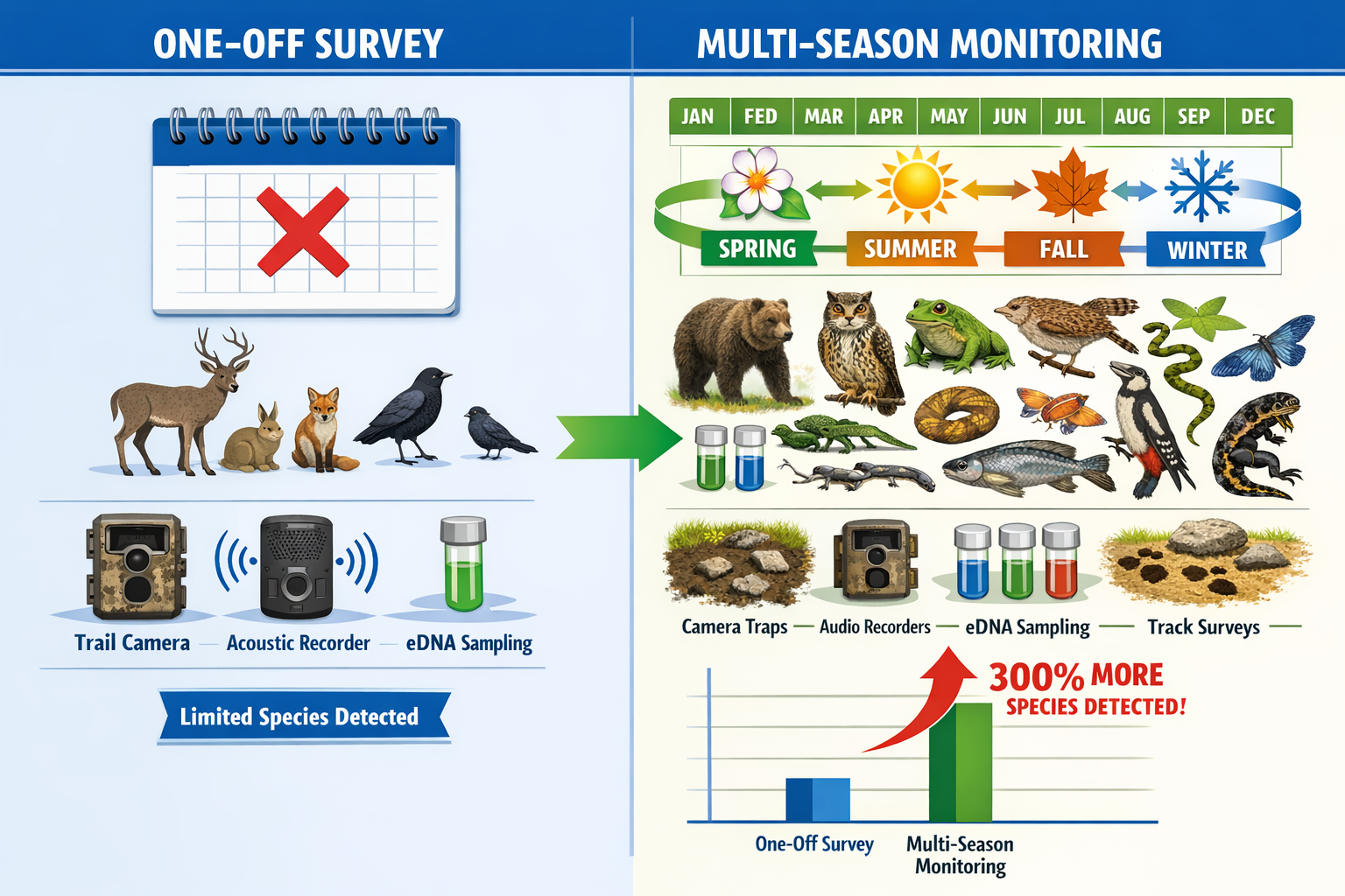
🔍 Seasonal variation creates false baselines – Single-visit surveys capture only a fraction of species present across annual cycles, missing migratory patterns, breeding populations, and seasonal habitat use.
📊 Technology enables continuous detection – TinyML devices, acoustic recorders, camera traps, and eDNA sampling now provide objective, timestamped records without requiring constant human presence.
✅ Policy frameworks demand sustained data – Biodiversity Net Gain requirements increasingly expect multi-season evidence to validate baseline assessments and track 30-year management outcomes.
🌍 European infrastructure supports mass monitoring – Nine thematic monitoring areas now structure biodiversity assessment strategies, including dedicated data management infrastructures for handling long-term information [2][3].
⚡ AI and digital twins complement field work – Machine learning applied to sensor data and virtual ecosystem simulations enable continuous assessment beyond traditional survey limitations [5].
The Fatal Flaws of One-Off Biodiversity Surveys
Seasonal Bias Distorts Baseline Assessments
Traditional biodiversity surveys typically involve field ecologists visiting a site during optimal weather conditions within a narrow seasonal window. This approach creates systematic blind spots that compromise decision-making quality.
Spring surveys miss autumn migrants. Many bird species use British landscapes differently across seasons—breeding residents in summer become absent in winter, while winter visitors arrive from continental Europe. A May survey captures breeding activity but entirely misses overwintering populations that might depend on the same habitat features.
Weather-dependent species appear or disappear. Amphibians, reptiles, and invertebrates show dramatic activity variations based on temperature and moisture. A survey conducted during unseasonably cold weather might record zero reptile observations at a site supporting robust populations, leading to incorrect conclusions about habitat value.
Flowering periods determine plant detection. Botanical surveys conducted outside flowering seasons struggle to identify species accurately, particularly for grassland communities where vegetative identification requires specialist expertise. Critical indicator species might be completely overlooked.
Observer Variation Introduces Inconsistency
Human surveyors bring unavoidable variability to biodiversity assessment:
- Skill differences affect detection rates – Experienced ecologists identify more species than junior surveyors, creating inconsistent baselines across sites or years
- Fatigue reduces accuracy – Survey quality declines through long field days as concentration wanes
- Subjective judgments influence habitat assessments – Condition scoring relies on professional judgment that varies between individuals
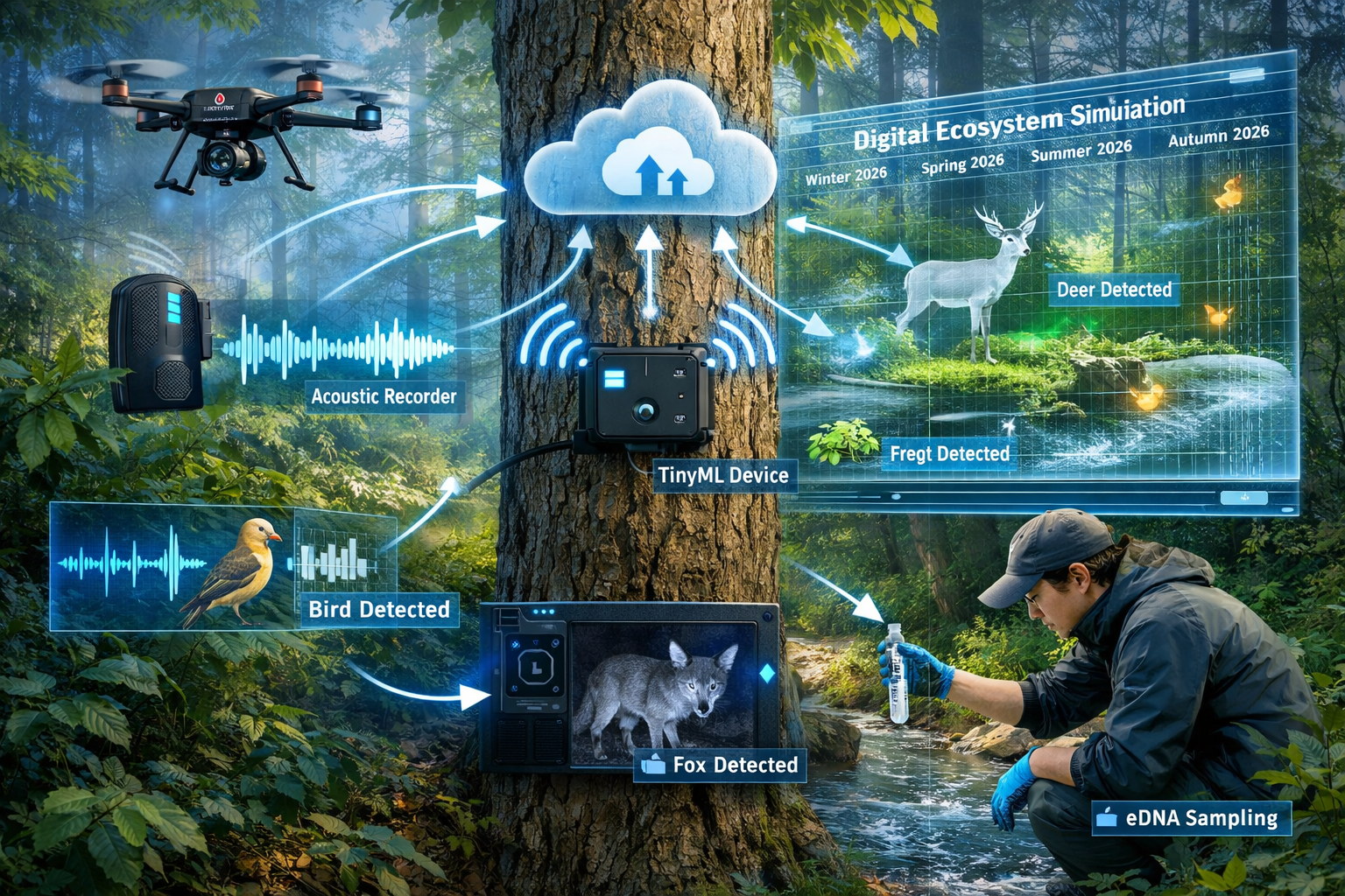
Sensor-based collection methods (camera traps, acoustic recorders, drones) provide verifiable vouchers for every observation with specific timestamps, creating objective continuous records rather than relying on observer-dependent field visits [5].
Cost Constraints Limit Survey Effort
Budget pressures push clients toward minimum viable survey effort. When conducting biodiversity impact assessments, developers often request the absolute minimum number of visits required for planning compliance, creating datasets too sparse to capture genuine ecological patterns.
Single-season surveys cannot distinguish:
- Temporary population fluctuations from long-term trends
- Weather-driven absences from genuine local extinctions
- Incidental observations from core habitat use
- Natural variation from human-caused impacts
Why Multi-Season Biodiversity Monitoring Outperforms One-Off Surveys in 2026
Continuous Data Reveals True Ecological Patterns
Multi-season monitoring protocols transform biodiversity assessment from snapshot photography into time-lapse documentation. This fundamental shift enables pattern recognition impossible with isolated surveys.
Annual cycles become visible. Twelve months of camera trap data reveals which mammal species use a woodland year-round versus those making seasonal movements. This distinction matters enormously for habitat management—permanent residents require different conservation approaches than transient visitors.
Population trends emerge from noise. A single survey showing low bat activity might indicate poor habitat quality, seasonal absence, or simply bad weather on survey night. Monthly acoustic monitoring across a year distinguishes these scenarios, revealing whether populations are stable, declining, or recovering.
Phenological shifts indicate climate impacts. Multi-year continuous monitoring detects earlier breeding seasons, shifted migration timing, and altered plant flowering periods—critical signals of ecosystem change that single surveys cannot capture.
"Integrated approaches that recognize the interdependence of climate, biodiversity, water and human wellbeing" require sustained data collection to interpret emerging signals across contexts [4].
Technology Enables Affordable Continuous Monitoring
The 2026 conservation technology landscape has transformed what's economically feasible for sustained biodiversity assessment.
TinyML devices provide real-time detection. These low-power devices don't require internet connectivity and enable real-time biodiversity detection in remote landscapes, directly supporting evidence-based conservation decisions without the limitations of sporadic surveys [4]. A single TinyML audio recorder can operate for months on battery power, continuously identifying bird and bat species through acoustic signatures.
eDNA sampling captures cryptic species. Environmental DNA collected from water or soil samples detects species presence without direct observation. Monthly eDNA sampling across seasons builds comprehensive species inventories including elusive mammals, amphibians, and aquatic organisms that traditional surveys struggle to record reliably.
Digital twins simulate ecosystem dynamics. Computer simulations of real-world ecosystems enable ongoing prediction of biodiversity changes, allowing continuous virtual monitoring that complements field-based long-term data collection [5]. These models integrate weather data, habitat conditions, and species observations to forecast population responses to management interventions.
Policy Frameworks Increasingly Demand Sustained Evidence
Regulatory expectations are shifting decisively toward continuous monitoring requirements that one-off surveys cannot satisfy.
Biodiversity Net Gain (BNG) requirements mandate 30-year habitat management and monitoring commitments. Demonstrating that enhancement habitats actually deliver promised biodiversity gains requires repeated assessment across seasons and years. A single post-construction survey proves nothing about long-term habitat trajectory.
The nine thematic monitoring areas now structuring European biodiversity assessment strategies include dedicated data management and infrastructures for handling, storing, and disseminating long-term information [2][3]. This institutional framework acknowledges that continuous monitoring requires robust governance beyond individual project budgets.
When planning projects to achieve 10% Biodiversity Net Gain, developers must demonstrate baseline conditions with sufficient confidence to calculate precise biodiversity unit values. Multi-season data provides the statistical power to defend these calculations against challenge, reducing planning risk.
Data Quality Supports Defensible Decision-Making
Statistical confidence increases with sample size. Twelve monthly surveys provide 12 data points per year; continuous sensor deployment provides thousands. This difference matters when stakeholders challenge baseline assessments or dispute whether management interventions succeeded.
Temporal replication separates signal from noise. Did bat activity decline because of habitat degradation, or because surveyors visited during poor weather? Multi-season data answers this question definitively through repeated measurements that average out random variation.
Verifiable records withstand scrutiny. Timestamped photographs from camera traps and audio spectrograms from acoustic recorders provide objective evidence that subjective field notes cannot match. When planning applications face legal challenge, this documentation quality becomes critical.
Implementing Effective Multi-Season Monitoring Programs
Design Protocols Around Ecological Questions
Effective continuous monitoring begins with clear objectives that guide technology selection and sampling frequency.
Define what success looks like. Are you tracking whether protected species persist? Monitoring habitat condition trends? Validating that enhancement areas attract target species? Each question demands different sensor types, deployment patterns, and analysis approaches.
Match technology to target taxa:
- 🦇 Bats – Static acoustic detectors recording nightly across seasons
- 🦊 Mammals – Camera traps on wildlife trails with seasonal rotation
- 🐸 Amphibians – eDNA water sampling monthly plus breeding season surveys
- 🦅 Birds – Acoustic recorders capturing dawn chorus year-round
- 🌿 Plants – Drone multispectral imagery quarterly to track vegetation change
Establish baseline duration. Minimum 12-month pre-construction monitoring captures full annual cycles. Two-year baselines better separate annual variation from genuine trends, particularly for species with biennial breeding patterns or boom-bust population dynamics.
Integrate Automated Sensors with Traditional Surveys
Multi-season monitoring works best when combining continuous automated data collection with targeted expert surveys that provide context and validation.
Sensors provide continuous presence detection. Camera traps and acoustic recorders document which species use a site and when, building comprehensive species inventories that inform survey timing.
Expert surveys add ecological interpretation. Ecologists visiting quarterly can assess habitat condition, identify management issues, and investigate unexpected sensor results. A camera trap might photograph a badger, but an ecologist determines whether the sett is active, expanding, or abandoned.
Hybrid approaches optimize cost-effectiveness. Rather than monthly ecologist visits at premium day rates, deploy sensors for continuous monitoring with quarterly expert interpretation. This approach typically costs 40-60% less than traditional monthly surveys while providing superior data quality.
Establish Data Management Infrastructure
The shift toward continuous monitoring creates data volumes that overwhelm traditional spreadsheet-based workflows. Institutional infrastructure becomes essential.
Cloud storage enables team access. Camera trap images, acoustic recordings, and eDNA results must be stored securely with version control, allowing multiple team members to access data without email attachments or USB drives.
Automated analysis reduces processing time. AI techniques applied to large-scale eDNA datasets and high-resolution remote sensing data improve understanding of biodiversity distribution, enabling continuous assessment rather than manual review of thousands of images [5].
Standardized formats support long-term value. Data collected today should remain usable in 30 years when BNG monitoring obligations conclude. Adopting standardized formats aligned with national biodiversity data infrastructure ensures long-term accessibility.
The recognition that data management infrastructures are foundational to systematic monitoring [1] reflects institutional understanding that continuous collection requires investment beyond field equipment.
Build Capacity for Long-Term Commitment
Multi-season monitoring represents a philosophical shift from project-based survey work to sustained ecological stewardship.
Train teams in sensor deployment and maintenance. Camera traps require battery changes, memory card rotation, and vegetation management around detection zones. Acoustic recorders need weatherproofing checks and firmware updates. Building internal capacity reduces ongoing costs.
Establish quality control protocols. Continuous data streams require systematic review procedures to catch equipment failures, identify data gaps, and flag anomalous results requiring investigation.
Plan for technology evolution. Sensor capabilities improve rapidly. TinyML devices available in 2026 offer detection accuracy unimaginable five years ago. Long-term monitoring programs must budget for periodic equipment upgrades while maintaining data continuity.
Equity in monitoring infrastructure is becoming a formal focus, with recognition that ensuring technologies "work for a wide range of users—including communities with limited digital infrastructure" requires sustained capacity building [4].
Emerging Challenges Requiring Continuous Observation
The 2026 horizon scan for biodiversity conservation identifies several emerging phenomena that demand sustained monitoring rather than episodic assessment.
Soil Moisture Decline
Widespread soil moisture decline creates growing pressure on terrestrial and freshwater ecosystems, with implications for food production, biodiversity, and water security [4]. These changes unfold gradually across years, invisible to annual snapshot surveys but clearly revealed through continuous soil moisture sensors paired with vegetation monitoring.
Ocean Darkening
Declining light penetration across wide ocean regions affects marine productivity and food webs in ways only beginning to be understood [4]. Tracking these impacts requires sustained oceanographic monitoring integrated with marine biodiversity assessment—precisely the kind of long-term commitment that continuous monitoring enables.
Macroalgal Habitat Loss
Kelp forest vulnerability to warming and extreme events underscores coastal ecosystem threats requiring continuous observation to detect patterns and trigger timely interventions [4]. Annual surveys might miss the critical transition point when kelp coverage drops below recovery thresholds.
These emerging challenges share a common characteristic: they unfold across timescales that make one-off surveys inadequate for detection, let alone management response.
The European Infrastructure for Mass Monitoring
BioMonWeek 2026's focus on "mass biodiversity monitoring" reflects institutional recognition that effective conservation requires coordinated infrastructure operating at landscape and continental scales [1][2].
The nine thematic monitoring areas structuring European biodiversity assessment include:
- Terrestrial ecosystem monitoring
- Marine ecosystem monitoring
- Freshwater ecosystem monitoring
- Species population monitoring
- Genetic diversity monitoring
- Remote sensing integration
- Citizen science coordination
- Data management infrastructure
- Policy-science interface
This framework acknowledges that continuous monitoring requires institutional commitment beyond individual project budgets. Developers working with biodiversity surveyors increasingly benefit from access to regional monitoring networks that provide context for site-specific assessments.
Harmonized protocols enable comparison. When multiple sites use compatible monitoring approaches, regional trends become distinguishable from local impacts. A developer can demonstrate that declining bird populations reflect landscape-scale agricultural intensification rather than site-specific construction impacts—but only with access to comparable continuous data from surrounding areas.
Shared infrastructure reduces costs. Rather than each project deploying isolated monitoring programs, regional networks enable data sharing, equipment pooling, and collaborative analysis that improve quality while reducing per-project costs.
Practical Considerations for Developers and Planners
Budget Multi-Season Monitoring Early
Planning biodiversity net gain projects requires realistic budgeting for continuous monitoring commitments that extend decades beyond construction completion.
Pre-construction baseline monitoring (12-24 months): £15,000-£35,000 depending on site size and habitat complexity, including sensor deployment, quarterly expert surveys, and data analysis.
Post-construction monitoring (30 years for BNG): £3,000-£8,000 annually for sensor maintenance, data management, and periodic expert review. Total 30-year commitment: £90,000-£240,000.
These figures represent significant increases over traditional one-off survey approaches but deliver proportionally greater data quality and regulatory confidence.
Integrate Monitoring with Adaptive Management
Continuous data collection enables adaptive management approaches that respond to emerging ecological patterns.
Set trigger thresholds. Define biodiversity metrics that, if declining, trigger management intervention. For example: "If breeding bird territories decline 20% below baseline across two consecutive years, implement supplementary habitat enhancements."
Review data quarterly. Rather than waiting for annual reports, establish quarterly review cycles that identify issues while corrective action remains feasible.
Document management responses. When monitoring reveals problems, record what interventions were implemented and whether they succeeded. This creates institutional learning that improves future project outcomes.
Communicate Value to Stakeholders
Clients often resist multi-season monitoring costs until they understand the risk reduction value.
Frame monitoring as insurance. A £30,000 baseline monitoring program protects a £5 million development from planning refusal or costly mid-construction design changes. The risk-adjusted value proposition becomes compelling.
Highlight regulatory trends. Planners increasingly expect multi-season evidence for significant applications. Proactive investment in continuous monitoring accelerates approvals and reduces challenge risk.
Demonstrate competitive advantage. Developments with robust biodiversity credentials attract environmentally conscious buyers and tenants at premium prices, creating commercial value beyond regulatory compliance.
Conclusion

Multi-Season Biodiversity Monitoring: Why Continuous Data Collection Outperforms One-Off Surveys in 2026 reflects a fundamental evolution in ecological assessment practice. Static snapshots that once satisfied planning requirements now appear inadequate against emerging regulatory expectations, technological capabilities, and scientific understanding of ecosystem dynamics.
The convergence of affordable sensor technology, AI-powered analysis, and institutional infrastructure for mass monitoring [1][2][5] creates unprecedented opportunities for ecology professionals to deliver continuous data streams that separate weather variation from genuine biodiversity trends. These capabilities transform conservation from reactive problem-solving into proactive stewardship guided by objective, verifiable evidence.
For developers, the shift toward multi-season monitoring represents both challenge and opportunity. Initial costs exceed traditional survey approaches, but the risk reduction value and improved decision-making quality justify investment. Projects with robust continuous monitoring programs navigate planning processes more smoothly, defend biodiversity net gain calculations with greater confidence, and demonstrate genuine environmental stewardship that enhances commercial value.
Next Steps for Implementation
For ecology consultants:
- Audit current monitoring protocols against multi-season best practices
- Invest in sensor technology training and data management infrastructure
- Develop standardized continuous monitoring packages for common project types
- Engage with regional monitoring networks to access comparative datasets
For developers and planners:
- Budget 12-24 month baseline monitoring periods into project timelines
- Request multi-season data when reviewing biodiversity impact assessments
- Establish 30-year monitoring budgets aligned with BNG obligations
- Integrate continuous monitoring data into adaptive management frameworks
For policymakers:
- Support regional monitoring infrastructure that reduces per-project costs
- Establish standardized data formats enabling long-term accessibility
- Provide guidance on acceptable sensor-based evidence for planning decisions
- Invest in capacity building for communities with limited digital infrastructure [4]
The transition from episodic surveys to continuous monitoring represents more than methodological refinement—it signals a maturing conservation sector capable of delivering the sustained, evidence-based stewardship that biodiversity recovery demands. As BioMonWeek 2026 convenes in Montpellier to advance mass monitoring infrastructure [1][2], ecology professionals who embrace multi-season approaches position themselves at the forefront of this transformation.
References
[1] Biodiversity Monitoring Week 2026 To Place In Montpellier – https://www.gbif.se/news/2026/biodiversity-monitoring-week-2026-to-place-in-montpellier/
[2] Biomonweek2026 – https://www.biodiversa.eu/2025/11/20/biomonweek2026/
[3] Biomonweek 2026 – https://www.monitoringzentrum.de/en/events/biomonweek-2026
[4] Whats Next For Biodiversity Conservation Insights From The 2026 Horizon Scan – https://www.unep-wcmc.org/en/news/whats-next-for-biodiversity-conservation-insights-from-the-2026-horizon-scan
[5] Sbdi Days 2026 Artificial Intelligence In Ecology And Biodiversity Research 9077 – https://lyyti.events/p/SBDI_Days_2026__Artificial_Intelligence_in_Ecology_and_Biodiversity_Research_9077
