
Coastal ecosystems contribute approximately £48 billion annually to the UK economy, yet fewer than 15% of development projects adequately assess biodiversity impacts across the land-sea transition zone. As Biodiversity Net Gain (BNG) regulations mature in 2026, this critical oversight threatens both compliance and ecological integrity. The challenge facing coastal ecologists is clear: traditional survey methods treat terrestrial and marine environments as separate entities, missing the complex interactions that define estuarine resilience and nutrient cycling.
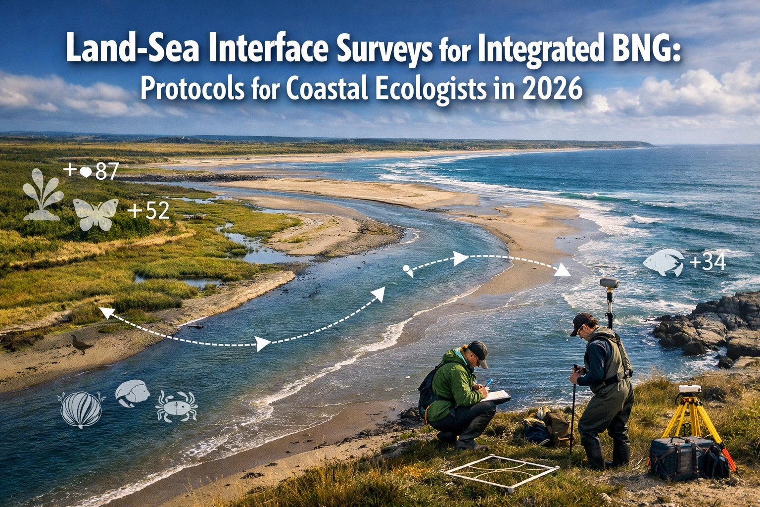
Land-Sea Interface Surveys for Integrated BNG: Protocols for Coastal Ecologists in 2026 represents a paradigm shift in how professionals approach coastal development assessments. This comprehensive guide bridges the gap between terrestrial and marine survey methodologies, providing cross-disciplinary tools that capture the full ecological value of transitional habitats.
Key Takeaways
- 🌊 Integrated approach required: Land-sea interface surveys must combine terrestrial and marine methodologies to accurately assess coastal BNG, capturing nutrient cycles and habitat connectivity that traditional separate surveys miss
- 📊 Cross-disciplinary protocols: 2026 best practices incorporate hydrodynamic modeling, biogeochemical sampling, and ecological surveys across intertidal zones to meet regulatory requirements
- 🔄 Resilience metrics matter: Coastal BNG assessments must evaluate climate adaptation capacity, including flood defense, carbon sequestration, and ecosystem service provision over 30-year timeframes
- 🛠️ Specialized toolkits available: New data integration frameworks and spatial planning tools enable surveyors to bridge terrestrial-marine boundaries effectively
- ⚖️ Regulatory alignment: Understanding how Biodiversity Net Gain applies to coastal interfaces ensures compliance while maximizing ecological outcomes
Understanding the Land-Sea Interface Challenge in BNG Implementation
The land-sea interface—comprising estuaries, salt marshes, mudflats, and intertidal zones—presents unique challenges for biodiversity assessment. These transitional ecosystems function as neither purely terrestrial nor marine environments, yet they support extraordinary biodiversity and provide critical ecosystem services.
Why Traditional Survey Methods Fall Short
Conventional biodiversity surveys typically employ separate protocols for land and sea, creating artificial boundaries that ignore ecological reality. A development project affecting a coastal site might receive a terrestrial habitat survey following Phase 1 methodology and a separate marine survey using different classification systems. This fragmented approach fails to capture:
- Nutrient cycling pathways that connect upland watersheds to marine systems
- Migratory species dependencies on multiple habitat types across the interface
- Sediment dynamics influencing both terrestrial vegetation and marine benthic communities
- Tidal influences that create unique habitat gradients and temporal variability
Research presented at international forums has emphasized the need for integrated approaches to coastal resilience, particularly regarding pollution crossing the land-sea interface and adaptation strategies[3]. These discussions highlight how fragmented survey methodologies undermine effective coastal management and biodiversity conservation.
The BNG Regulatory Context for Coastal Projects
Since the mandatory implementation of Biodiversity Net Gain requirements, developers must demonstrate a minimum 10% net gain in biodiversity value. For coastal projects, this calculation becomes complex when habitats span the terrestrial-marine boundary.
Key regulatory considerations include:
| Aspect | Terrestrial BNG | Marine BNG | Interface Challenge |
|---|---|---|---|
| Metric System | UK Habitat Classification | Marine habitat classifications | Inconsistent between systems |
| Condition Assessment | Well-established criteria | Emerging frameworks | Transitional zones poorly defined |
| Temporal Dynamics | Seasonal variation | Tidal and seasonal cycles | Multiple overlapping timescales |
| Spatial Boundaries | Clear property lines | Mean high water complications | Legal and ecological misalignment |
Understanding what developers need in a BNG report becomes particularly important when projects affect coastal interfaces, as standard templates may not adequately address transitional habitat complexities.
Integrated Survey Protocols for Land-Sea Interface Surveys in 2026
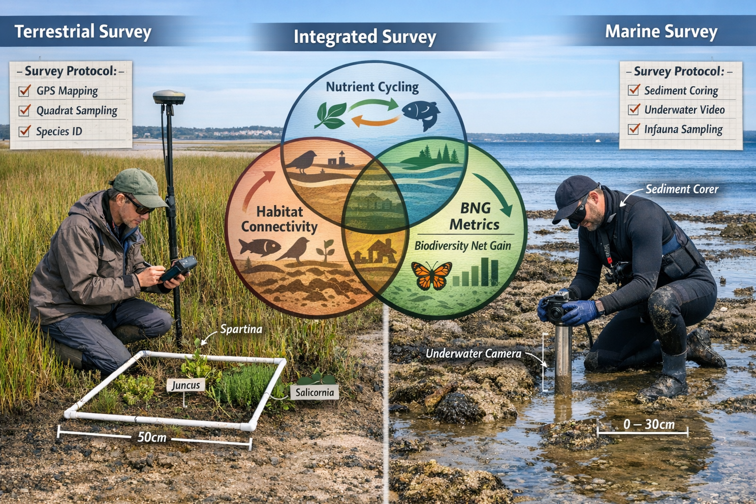
Effective Land-Sea Interface Surveys for Integrated BNG: Protocols for Coastal Ecologists in 2026 require a systematic approach that acknowledges ecological continuity while meeting regulatory requirements. The following protocols represent current best practices for coastal assessments.
Phase 1: Preliminary Desktop Assessment and Scoping
Before fieldwork begins, coastal ecologists must conduct comprehensive desktop reviews that integrate terrestrial and marine data sources:
Essential data layers:
- Topographic and bathymetric surveys (LiDAR and sonar integration)
- Historical habitat mapping from aerial photography and satellite imagery
- Hydrological modeling outputs showing tidal ranges and freshwater inputs
- Protected species records across terrestrial and marine databases
- Sediment transport studies and coastal erosion assessments
- Water quality monitoring data including nutrient concentrations
The Federated Marine Spatial Data Infrastructure (FMSDI) pilot project has advanced international best practices for data integration at the intertidal zone, emphasizing interoperability frameworks that enable seamless combination of terrestrial and marine datasets[1]. These standards help surveyors overcome technical barriers to integrated assessment.
Phase 2: Establishing Survey Transects Across Habitat Gradients
Rather than treating the shoreline as a boundary, integrated surveys establish transects that extend from fully terrestrial to fully marine environments, capturing the complete ecological gradient.
Transect design principles:
- Perpendicular orientation to the coastline, extending minimum 100m inland and seaward where feasible
- Multiple replicates across the project site to capture spatial variability
- Stratification by geomorphological features (e.g., creek systems, elevation zones)
- Tidal stage consideration with surveys conducted at multiple tidal states
Each transect should document:
- Vegetation communities and succession patterns
- Soil/sediment characteristics and organic content
- Invertebrate communities (terrestrial and marine)
- Water chemistry parameters at multiple points
- Evidence of wildlife use (tracks, feeding signs, nesting sites)
Phase 3: Biogeochemical Sampling for Nutrient Cycle Assessment
One of the most critical—and often overlooked—aspects of Land-Sea Interface Surveys for Integrated BNG: Protocols for Coastal Ecologists in 2026 is the assessment of nutrient cycling. Coastal interfaces serve as biogeochemical hotspots where nutrient transformation processes significantly influence ecosystem function.
Key sampling protocols:
🔬 Water sampling at freshwater input points, mid-salinity zones, and marine end-members
- Nitrogen species (nitrate, nitrite, ammonium)
- Phosphorus fractions (dissolved and particulate)
- Dissolved organic carbon
- Suspended sediment concentrations
🔬 Sediment core analysis across the intertidal gradient
- Organic matter content and carbon stocks
- Nutrient pools and availability
- Redox conditions and microbial activity indicators
- Grain size distribution affecting habitat suitability
🔬 Biological indicators of nutrient status
- Macroalgae and phytoplankton community composition
- Benthic invertebrate functional groups
- Vegetation nitrogen content and C:N ratios
These biogeochemical data inform both baseline condition assessments and predictions of how proposed developments might alter nutrient flows, affecting downstream marine ecosystems. For developers creating biodiversity plans, understanding these connections is essential for designing effective mitigation.
Phase 4: Hydrodynamic and Sediment Transport Modeling
Physical processes drive habitat formation and maintenance at the land-sea interface. Integrated BNG surveys must incorporate hydrodynamic assessments to predict how development activities might alter:
- Tidal flow patterns affecting habitat inundation regimes
- Wave energy distribution influencing erosion and accretion
- Sediment budgets determining mudflat and marsh stability
- Freshwater discharge creating salinity gradients
The upcoming EGU26 session on coastal processes and land-sea interface dynamics will showcase observational, modeling, and theoretical contributions addressing coastal hydrodynamics under changing climate conditions[4]. These scientific advances provide the foundation for robust impact predictions in BNG assessments.
Cross-Disciplinary Tools and Data Integration for Coastal BNG
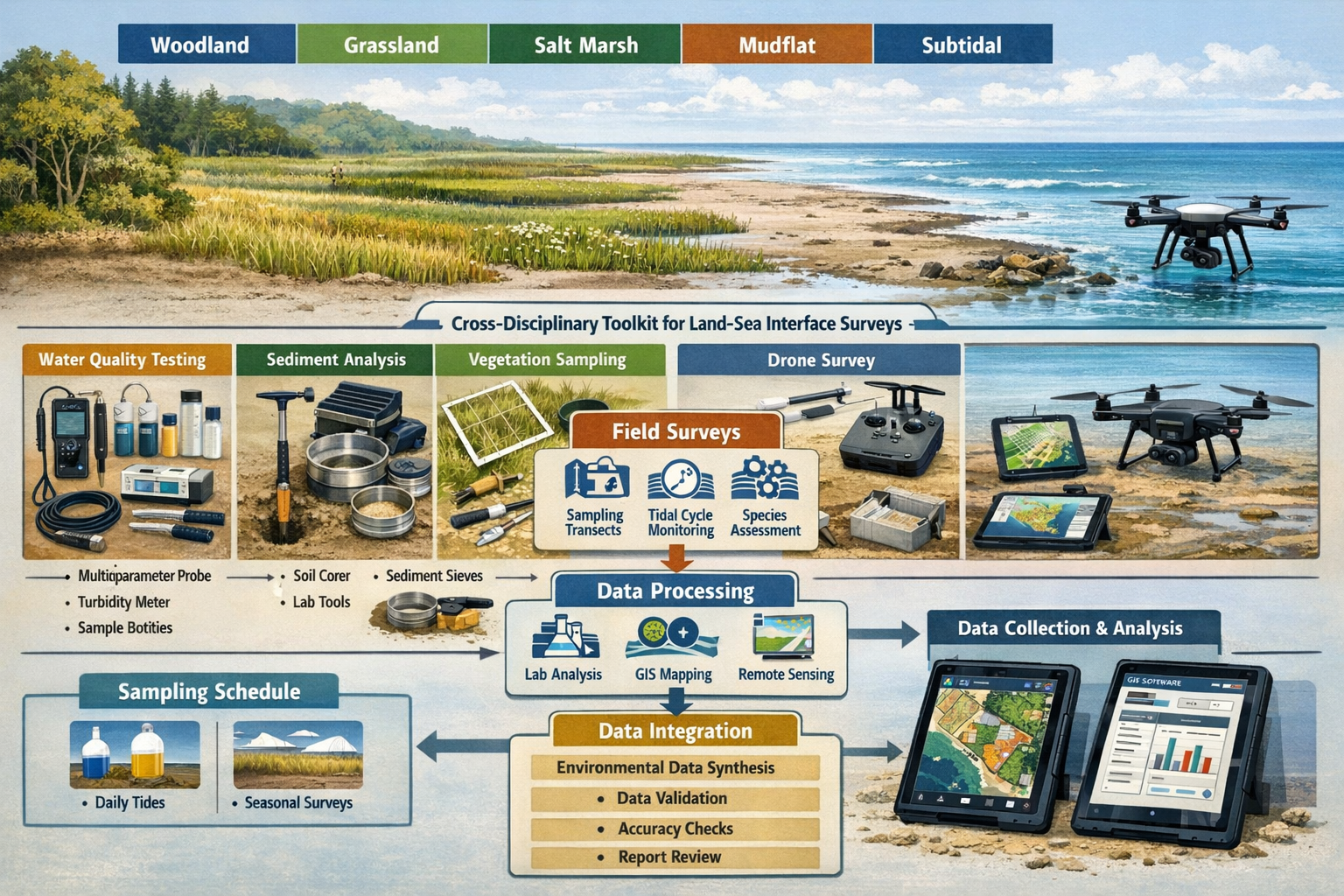
Successfully implementing Land-Sea Interface Surveys for Integrated BNG: Protocols for Coastal Ecologists in 2026 requires specialized tools that bridge traditional disciplinary boundaries. The following resources represent the current state-of-practice for coastal ecological assessment.
Spatial Planning and Visualization Tools
NatureServe's Integrated Land-Sea Planning Toolkit provides a framework for addressing complex planning across land-sea boundaries, incorporating spatial data on habitat distribution, species ranges, and ecosystem connectivity[5]. While originally developed for broader conservation planning, these tools adapt well to BNG assessment needs.
Key capabilities include:
- Multi-habitat mapping that recognizes transitional zones
- Connectivity analysis showing movement corridors across interfaces
- Scenario modeling to compare development alternatives
- Cumulative impact assessment across multiple projects
For projects requiring off-site BNG delivery, these spatial tools help identify appropriate compensation sites that maintain ecological connectivity across the land-sea interface.
Field Data Collection Technologies
Modern survey protocols leverage technology to improve data quality and integration:
📱 Mobile data collection apps with customized forms capturing both terrestrial and marine parameters
- Real-time GPS positioning with sub-meter accuracy
- Photo documentation with automatic geotagging
- Standardized dropdown menus ensuring consistency
- Offline functionality for remote coastal locations
🚁 Drone-based remote sensing providing comprehensive spatial coverage
- High-resolution orthophotography for habitat mapping
- Multispectral imagery for vegetation health assessment
- Topographic surveys using photogrammetry
- Temporal monitoring to detect changes
🌊 Autonomous water quality sensors enabling continuous monitoring
- Multi-parameter sondes measuring salinity, temperature, dissolved oxygen
- Nutrient analyzers providing high-frequency data
- Deployment across tidal cycles capturing dynamic conditions
Metric Calculation and Biodiversity Accounting
Translating integrated survey data into BNG metrics requires careful consideration of how terrestrial and marine systems are valued. Current approaches include:
-
Separate calculation then aggregation: Apply terrestrial metric to land habitats, marine metric to subtidal areas, then combine with appropriate weighting for transitional zones
-
Hybrid metric development: Create interface-specific condition assessment criteria that recognize unique characteristics of salt marshes, mudflats, and reed beds
-
Functional equivalence approach: Value habitats based on ecosystem service provision (nutrient cycling, carbon storage, nursery function) rather than classification alone
Regardless of approach, achieving the 10% BNG requirement at coastal sites demands rigorous baseline assessment and creative enhancement design that works with natural processes.
Resilience Assessment and Climate Adaptation in Coastal BNG
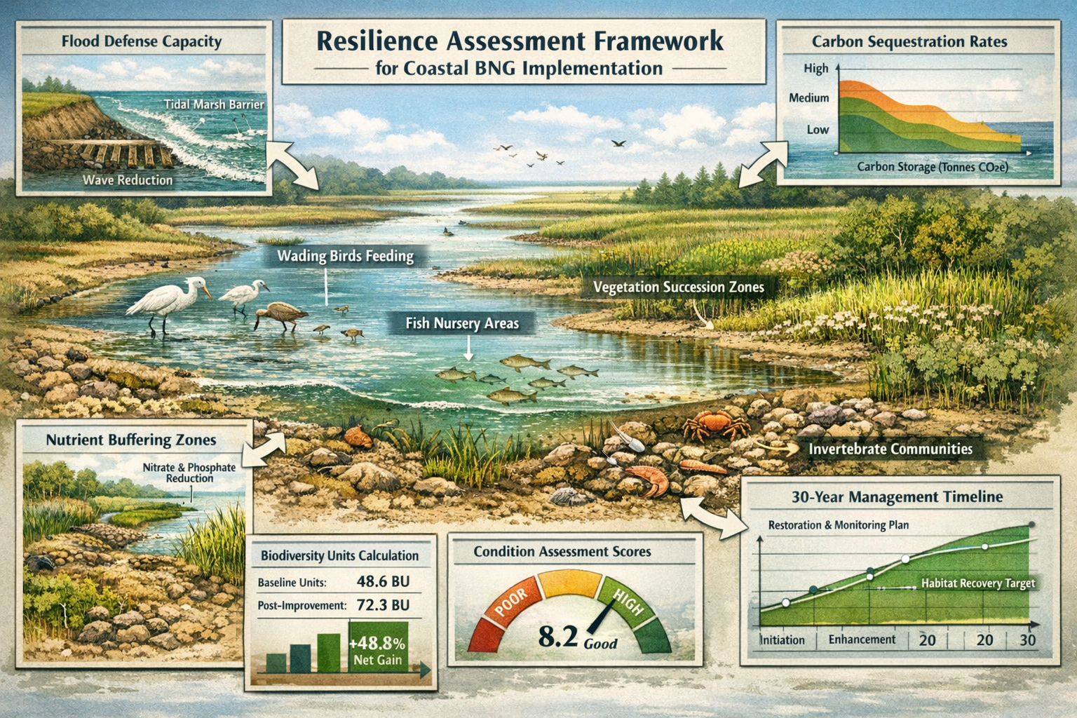
A forward-thinking approach to Land-Sea Interface Surveys for Integrated BNG: Protocols for Coastal Ecologists in 2026 must incorporate climate resilience as a core assessment criterion. Coastal ecosystems face accelerating pressures from sea-level rise, increased storm intensity, and changing precipitation patterns.
Building Climate Adaptation into Survey Protocols
Resilience assessment extends beyond simple habitat condition scoring to evaluate adaptive capacity:
🌡️ Climate vulnerability indicators:
- Elevation relative to projected sea-level rise scenarios (2050, 2080)
- Landward migration space for salt marsh transgression
- Sediment supply sufficiency for vertical accretion
- Freshwater input reliability under drought scenarios
💪 Adaptive capacity metrics:
- Habitat diversity providing functional redundancy
- Genetic diversity in key foundation species
- Connectivity to climate refugia
- Management flexibility for natural process restoration
🛡️ Ecosystem service provision:
- Flood and storm surge attenuation capacity
- Carbon sequestration rates (blue carbon accounting)
- Water quality improvement through nutrient buffering
- Commercial and recreational fisheries support
These resilience metrics inform both impact assessment and enhancement design. Guidance for landowners interested in providing BNG habitat should emphasize climate-adapted approaches that deliver long-term biodiversity value.
Managed Realignment and Natural Process Restoration
The most effective coastal BNG strategies often involve removing artificial constraints and allowing natural processes to create and maintain habitat mosaics. Survey protocols should identify opportunities for:
- Managed realignment where seawalls can be set back, creating intertidal habitat
- Creek restoration reconnecting fragmented salt marsh systems
- Sediment management supporting natural accretion processes
- Freshwater inputs maintaining salinity gradients and habitat diversity
These nature-based solutions typically deliver multiple benefits beyond biodiversity, including enhanced flood protection and carbon storage. For developers exploring BNG off-site options, coastal realignment projects offer high-value biodiversity unit creation potential.
Implementation Challenges and Practical Solutions
Despite clear ecological rationale, implementing integrated land-sea interface surveys faces several practical obstacles:
Challenge 1: Expertise Gaps
Most ecological consultancies specialize in either terrestrial or marine work, rarely both. Building integrated survey capacity requires:
✅ Cross-training programs exposing terrestrial ecologists to marine methods and vice versa
✅ Collaborative partnerships between specialist firms
✅ Standardized protocols reducing the learning curve
✅ Quality assurance frameworks ensuring consistency
Challenge 2: Regulatory Uncertainty
Current BNG guidance provides limited direction on interface habitats. Coastal ecologists should:
✅ Engage early with local planning authorities to agree assessment approaches
✅ Document methodology decisions thoroughly in reports
✅ Reference emerging best practices from pilot projects
✅ Contribute to consultation processes shaping future guidance
Challenge 3: Cost and Time Constraints
Integrated surveys require more extensive fieldwork than traditional approaches. Managing project economics involves:
✅ Phased assessment with detailed surveys focused on high-value areas
✅ Remote sensing providing cost-effective broad-scale mapping
✅ Existing data leverage maximizing use of monitoring programs
✅ Early planning avoiding rushed assessments that miss critical windows
For projects with tight budgets, understanding BNG requirements for small developments helps prioritize essential survey components while maintaining compliance.
Case Study Applications: Integrated Surveys in Practice
Estuarine Development Project
A proposed marina expansion in a southern England estuary required integrated assessment spanning:
- Coastal grassland and scrub (terrestrial)
- Salt marsh and mudflat (interface)
- Subtidal seagrass beds (marine)
The integrated survey approach revealed that the development would fragment a critical migration corridor for overwintering waders, with impacts extending beyond the direct footprint. The assessment informed redesign that:
- Maintained tidal connectivity through the site
- Enhanced degraded salt marsh as on-site compensation
- Contributed to regional seagrass restoration as off-site provision
The project achieved 12% net gain while improving coastal resilience through nature-based flood defense.
Coastal Agricultural Land Conversion
A landowner converting low-grade agricultural land to biodiversity habitat engaged surveyors to maximize BNG unit value. Integrated assessment identified opportunities to:
- Breach drainage ditches allowing tidal inundation
- Create brackish pools supporting diverse invertebrate communities
- Establish salt marsh-grassland transitions
- Provide nesting habitat for declining coastal bird species
The resulting habitat mosaic generated high-value biodiversity units while sequestering significant blue carbon, creating additional revenue streams through emerging carbon markets.
Future Directions: Advancing Coastal BNG Practice
As Land-Sea Interface Surveys for Integrated BNG: Protocols for Coastal Ecologists in 2026 become standard practice, several developments will shape the field:
Enhanced Monitoring Technologies
Emerging sensor networks and autonomous systems will enable:
- Continuous biodiversity monitoring through acoustic and environmental DNA sampling
- Real-time water quality tracking informing adaptive management
- Satellite-based habitat condition assessment at landscape scales
Improved Metric Systems
Ongoing research will refine how interface habitats are valued within BNG frameworks:
- Functional trait-based approaches recognizing ecosystem service provision
- Dynamic metrics accounting for temporal variability in tidal systems
- Connectivity weighting that rewards habitat networks over isolated patches
Regional Coordination
Catchment-scale approaches will optimize BNG delivery:
- Strategic habitat networks planned across multiple developments
- Coordinated monitoring programs reducing duplication
- Shared data infrastructure supporting cumulative assessment
Professionals seeking to stay current should engage with initiatives like the EGU sessions on coastal processes[4] and contribute to evolving best practice guidance.
Conclusion: Implementing Integrated Coastal BNG Surveys
The transition to integrated Land-Sea Interface Surveys for Integrated BNG: Protocols for Coastal Ecologists in 2026 represents both a challenge and an opportunity for the ecological consulting profession. While these approaches require broader expertise and more comprehensive fieldwork than traditional methods, they deliver more accurate impact assessments, more effective mitigation designs, and ultimately better outcomes for coastal biodiversity.
Actionable Next Steps for Coastal Ecologists
For survey practitioners:
- Audit current capabilities against integrated protocol requirements
- Identify training needs and partnership opportunities
- Invest in cross-disciplinary field equipment and data systems
- Pilot integrated approaches on upcoming coastal projects
For developers and landowners:
- Engage ecological consultants with demonstrated coastal expertise early in project planning
- Budget adequately for comprehensive interface surveys
- Explore opportunities for nature-based solutions that deliver multiple benefits
- Consider buying biodiversity units from high-quality coastal habitat creation projects
For regulators and policymakers:
- Develop clear guidance on BNG metric application at land-sea interfaces
- Support pilot projects demonstrating best practices
- Facilitate data sharing and standardization across jurisdictions
- Recognize climate adaptation co-benefits in BNG valuation
The coastal zone—where land meets sea—represents one of the most biodiverse and economically valuable environments on Earth. By embracing integrated survey protocols that honor ecological reality rather than artificial boundaries, the BNG framework can drive meaningful conservation outcomes while supporting sustainable coastal development.
The tools, protocols, and understanding needed for effective coastal BNG assessment exist today. The question facing coastal ecologists in 2026 is not whether integrated approaches are possible, but whether we have the professional commitment to implement them consistently. The future of coastal biodiversity depends on the answer.
For additional support implementing these protocols, contact specialist biodiversity surveyors with coastal expertise who can guide your project through the complexities of land-sea interface assessment and ensure full regulatory compliance while maximizing ecological value.
References
[1] Html – https://portal.ogc.org/files/109299/html
[2] Full – https://www.frontiersin.org/journals/remote-sensing/articles/10.3389/frsen.2023.1125898/full
[3] Watch – https://www.youtube.com/watch?v=U7VUwItLGlE
[4] egu26.eu – https://www.egu26.eu/session/56243
[5] mediaspace.esri – https://mediaspace.esri.com/media/t/1_95cs1q35/244334392
