
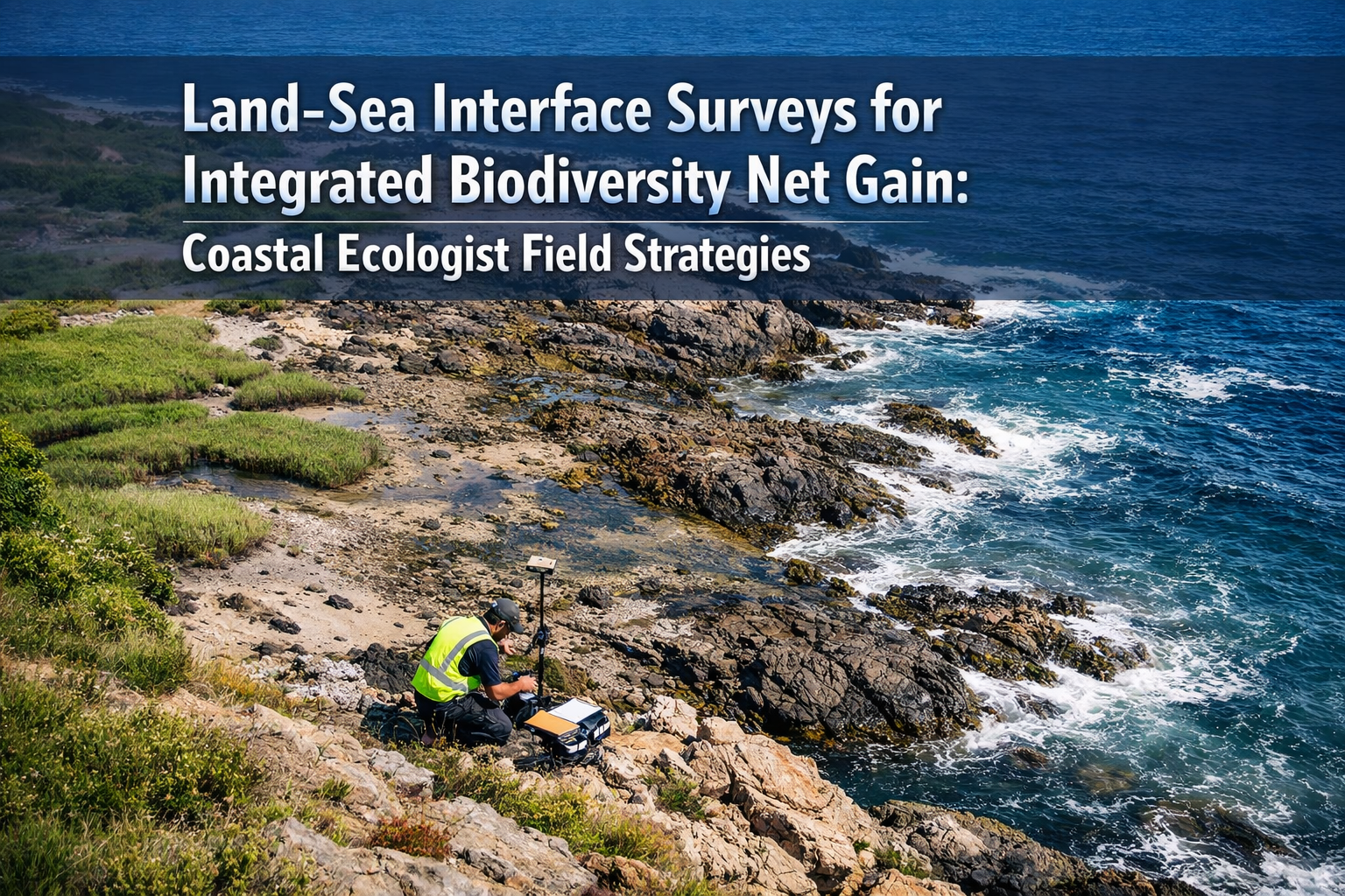
Coastal development projects lose an estimated 30-40% of potential biodiversity value when survey teams treat land and sea as separate entities. This critical oversight occurs at the land-sea interface—the transitional zone where terrestrial and marine ecosystems merge, creating unique habitats that traditional survey methodologies consistently undervalue or entirely miss. As Biodiversity Net Gain (BNG) requirements become mandatory across the UK in 2026, coastal ecologists face an urgent challenge: developing Land-Sea Interface Surveys for Integrated Biodiversity Net Gain: Coastal Ecologist Field Strategies that capture the full ecological complexity of these transitional zones.
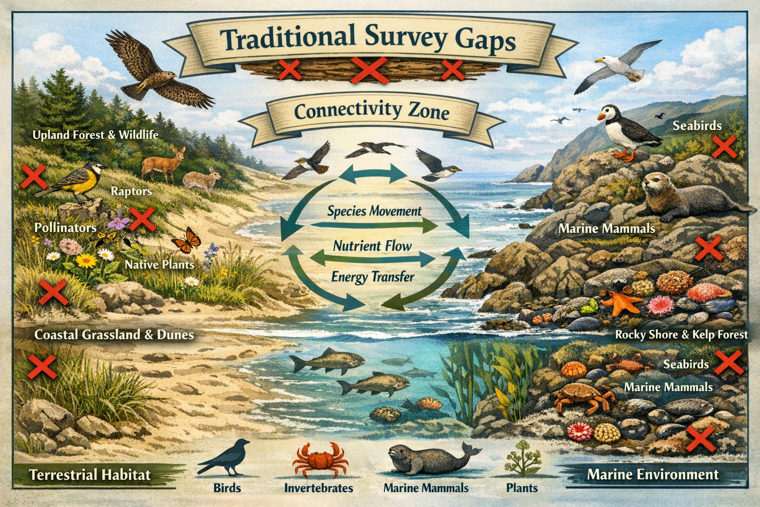
The land-sea interface represents one of the most biodiverse yet poorly understood environments on the planet. Standard terrestrial surveys typically stop at the high-water mark, while marine assessments begin below the low-water line. The critical intertidal and supratidal zones between these boundaries—home to specialized species, crucial nursery habitats, and vital ecological corridors—fall through the gaps. For coastal BNG projects to achieve genuine net gain, ecologists must adopt integrated survey approaches that recognize these transitional zones as distinct ecosystems requiring specialized assessment protocols.
Key Takeaways
- Transitional zones require specialized surveys: Traditional terrestrial or marine-only assessments miss 30-40% of biodiversity value at coastal interfaces
- Integrated methodologies capture connectivity: Coordinated land-sea surveys identify critical ecological linkages that separate assessments overlook
- Timing and tidal cycles matter: Effective coastal BNG surveys require strategic scheduling around tidal patterns, seasonal migrations, and breeding cycles
- Multi-disciplinary expertise is essential: Successful land-sea interface assessments demand collaboration between terrestrial ecologists, marine biologists, and coastal geomorphologists
- Enhanced monitoring delivers long-term value: Integrated baseline data enables more accurate impact prediction and effective post-development monitoring
Understanding the Land-Sea Interface: Why Traditional Surveys Fall Short
The land-sea interface encompasses multiple distinct but interconnected habitat zones: supralittoral (splash zone), eulittoral (intertidal), and sublittoral (shallow subtidal) areas. Each zone supports specialized communities adapted to unique environmental stresses including salinity fluctuations, wave action, desiccation risk, and tidal inundation cycles. Traditional survey approaches systematically undervalue these areas for several reasons.
The Survey Gap Problem
Most ecological consultancies organize their services along disciplinary lines—terrestrial ecology teams handle land-based assessments while separate marine teams address aquatic environments. This organizational structure creates practical and conceptual barriers to integrated assessment. Terrestrial ecologists may lack marine survey qualifications, while marine biologists often have limited experience with coastal vegetation communities or terrestrial invertebrates.
The result? Critical habitats fall between survey boundaries. Salt marshes, shingle beaches, coastal lagoons, and rocky shore communities receive inadequate assessment. Species that utilize both terrestrial and marine habitats during different life stages—including many birds, fish, and invertebrates—are poorly documented. Ecological processes connecting land and sea, such as nutrient cycling, sediment transport, and species dispersal, remain largely invisible to standard assessment protocols.
Connectivity and Ecosystem Function
Research demonstrates that land-sea connectivity drives ecosystem productivity and resilience[4]. Coastal habitats function as critical transition zones where:
- 🐦 Seabirds and waders move between marine feeding areas and terrestrial nesting sites
- 🐟 Fish species utilize intertidal pools and estuaries as nursery habitats before moving offshore
- 🌱 Nutrient exchange between marine and terrestrial systems supports primary productivity
- 🦀 Invertebrates migrate across tidal gradients during different life stages
- 💧 Freshwater inputs from land influence salinity gradients and marine community composition
When surveys treat these as separate systems, they fail to capture the functional connectivity that determines actual biodiversity value. A development that fragments this connectivity may appear acceptable when assessed through separate terrestrial and marine lenses, yet cause significant cumulative impacts when the integrated system is considered.
Developing Integrated Land-Sea Interface Surveys for Biodiversity Net Gain Projects
Effective Land-Sea Interface Surveys for Integrated Biodiversity Net Gain: Coastal Ecologist Field Strategies require fundamental changes to standard assessment approaches. These integrated methodologies must address both practical field challenges and conceptual frameworks for understanding transitional ecosystems.
Multi-Disciplinary Team Composition
Successful coastal BNG surveys demand cross-disciplinary expertise. The ideal team includes:
- Coastal ecologists with experience spanning terrestrial-marine boundaries
- Marine biologists qualified for intertidal and subtidal assessments
- Botanists specializing in halophytic (salt-tolerant) plant communities
- Ornithologists familiar with coastal and seabird ecology
- Geomorphologists who understand coastal processes and habitat dynamics
- GIS specialists capable of integrating spatial data across habitat types
Organizations with 25+ years of experience in marine and coastal projects demonstrate the value of maintaining integrated teams[1]. This expertise enables seamless coordination between assessment components and ensures no critical habitats or species fall through disciplinary gaps.
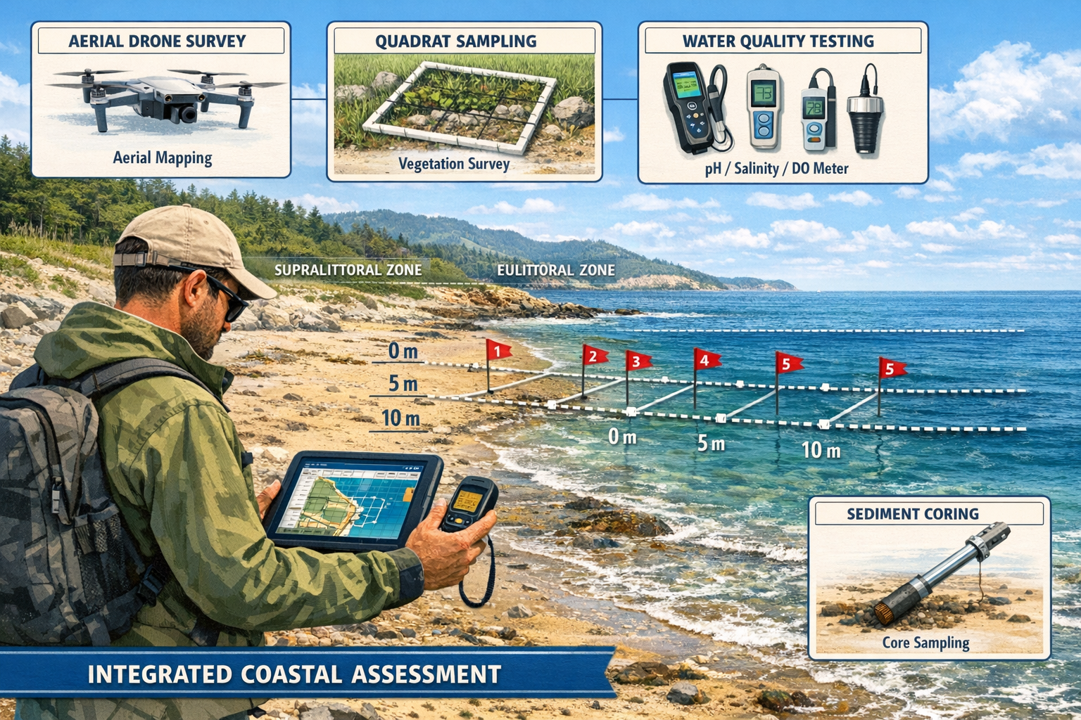
Establishing Survey Boundaries and Transect Design
Unlike standard habitat surveys with clear boundaries, land-sea interface assessments require flexible spatial frameworks that follow ecological gradients rather than arbitrary lines. Effective approaches include:
Perpendicular transect methodology: Establish survey transects running perpendicular to the coastline, extending from clearly terrestrial habitats (e.g., coastal grassland or woodland) through transitional zones to fully marine environments (e.g., sublittoral rock or sediment). This captures the full environmental gradient and documents species turnover across zones.
Tidal datum integration: Reference all spatial data to standardized tidal datums (Mean High Water Springs, Mean High Water Neaps, Mean Low Water, etc.) rather than arbitrary survey boundaries. This enables accurate habitat mapping and ensures consistency across survey seasons and years.
Buffer zone assessment: Extend terrestrial surveys at least 100-200 meters inland from the high-water mark to capture species utilizing coastal habitats for roosting, nesting, or foraging. Similarly, extend marine surveys into shallow subtidal zones to document juvenile fish and mobile invertebrates.
Temporal Considerations and Survey Timing
Coastal environments exhibit extreme temporal variability driven by tidal cycles, seasonal changes, and weather patterns. Strategic survey timing is essential for capturing representative baseline conditions:
| Survey Component | Optimal Timing | Rationale |
|---|---|---|
| Intertidal invertebrates | Spring low tides | Maximum exposure of lower shore zones |
| Coastal vegetation | June-August | Peak flowering for identification |
| Breeding birds | April-July | Nesting season, territory establishment |
| Wintering birds | November-February | Peak numbers of migratory species |
| Marine fish | Multiple seasons | Captures seasonal migrations and recruitment |
| Saltmarsh communities | Summer low tides | Accessible conditions, peak biomass |
Multiple survey visits across different tidal states and seasons are essential. A single survey cannot adequately characterize habitats that experience twice-daily inundation cycles and dramatic seasonal changes in community composition.
Habitat Condition Assessment Across Gradients
Biodiversity Net Gain assessments require habitat condition scoring to calculate biodiversity units. At land-sea interfaces, condition assessment must account for natural stress gradients that would appear as "poor condition" indicators in purely terrestrial contexts.
For example, sparse vegetation cover in the supralittoral zone reflects natural environmental stress (salt spray, desiccation, nutrient limitation) rather than degradation. Applying standard terrestrial condition criteria would systematically undervalue these naturally sparse but ecologically important habitats.
Integrated condition assessments should:
- ✅ Use habitat-specific condition criteria appropriate for coastal environments
- ✅ Consider natural stress gradients when evaluating vegetation structure
- ✅ Assess connectivity between adjacent habitat zones as a condition indicator
- ✅ Evaluate coastal process integrity (sediment supply, hydrological connectivity)
- ✅ Document anthropogenic impacts separately from natural environmental stress
Technology Integration for Coastal Surveys
Modern survey technologies offer significant advantages for land-sea interface assessments:
Drone-based aerial surveys provide cost-effective habitat mapping across large coastal areas, capturing the full terrestrial-marine gradient in single flights. High-resolution imagery enables detailed vegetation mapping, while repeat surveys document seasonal changes and coastal erosion.
GPS-enabled mobile data collection allows real-time georeferencing of observations across tidal zones, ensuring accurate spatial data even as water levels change during surveys.
Remote sensing and satellite imagery supports baseline habitat mapping and change detection over time, particularly valuable for monitoring coastal squeeze and habitat migration under climate change.
Underwater video surveys document subtidal communities without requiring extensive dive time, enabling broader spatial coverage of marine components.
Field Strategies for Coastal Ecologists: Practical Implementation
Translating integrated assessment principles into effective Land-Sea Interface Surveys for Integrated Biodiversity Net Gain: Coastal Ecologist Field Strategies requires attention to practical field logistics and safety considerations unique to coastal environments.
Safety Planning and Risk Management
Coastal surveys present distinctive hazards requiring specialized risk assessment:
- Tidal risks: Rapidly rising tides can cut off access to shore platforms and headlands. Survey teams must maintain constant awareness of tidal state and plan escape routes before accessing intertidal areas.
- Wave action: Unexpected large waves can sweep surveyors from rocky shores. Never turn your back on the sea, and avoid survey work during high wave conditions.
- Unstable substrates: Soft mud in saltmarshes and estuaries presents entrapment risks. Use appropriate footwear and survey poles to test substrate stability.
- Weather exposure: Coastal sites offer minimal shelter from wind, rain, and sun. Appropriate clothing and sun protection are essential.
- Access challenges: Many coastal sites require boat access or traversing private land. Secure necessary permissions and transport arrangements well in advance.
All field staff should hold appropriate safety qualifications, including first aid certification and, where relevant, marine safety training.
Sampling Protocols for Transitional Habitats
Effective sampling in land-sea interface zones requires adapted methodologies:
Vegetation surveys: Use stratified random sampling within habitat zones rather than attempting uniform coverage across the full gradient. Record species presence, abundance, and zonation patterns. Document transitions between plant communities, which often indicate important ecological boundaries.
Invertebrate sampling: Employ multiple techniques appropriate to different zones—pitfall traps in terrestrial areas, timed searches in the supralittoral, quadrat sampling in the intertidal, and grab samples or cores in subtidal sediments. This multi-method approach captures the full invertebrate community across the gradient.
Bird surveys: Conduct both breeding season territory mapping and non-breeding season counts. Record habitat use patterns, noting whether birds are feeding, roosting, or nesting. Pay particular attention to high-tide roost sites, which may be located well inland from feeding areas.
Marine species: Combine visual census techniques (snorkel or dive surveys) with environmental DNA (eDNA) sampling to document fish and mobile invertebrates. eDNA offers particular advantages in turbid coastal waters where visual surveys are challenging.
Data Integration and Biodiversity Unit Calculation
The ultimate goal of integrated surveys is producing accurate biodiversity unit calculations that reflect the true value of land-sea interface habitats. This requires:
Appropriate habitat classification: Use habitat classification systems that recognize coastal transitional habitats as distinct types rather than forcing them into terrestrial or marine categories. UK Habitat Classification provides suitable categories for most coastal habitats.
Connectivity weighting: Consider developing site-specific multipliers that account for connectivity value when calculating biodiversity units. Habitats that provide critical linkages between terrestrial and marine systems may warrant enhanced valuation.
Functional assessment: Document ecosystem services and ecological functions provided by transitional habitats, including coastal defense, water quality improvement, and carbon sequestration. While not directly incorporated into biodiversity unit calculations, this information supports mitigation hierarchy decisions[2].
Stakeholder Engagement and Regulatory Coordination
Coastal BNG projects typically involve multiple regulatory authorities with overlapping jurisdictions. Effective engagement requires:
- Early consultation with local planning authorities, Natural England, Marine Management Organisation, and Environment Agency
- Coordinated assessment that addresses both terrestrial planning requirements and marine licensing needs
- Transparent methodology documentation explaining how integrated surveys address regulatory requirements from multiple frameworks
- Regular communication throughout the assessment process to address concerns and incorporate feedback
Many coastal developments require both terrestrial planning permission and marine licenses. Integrated surveys that satisfy both regulatory frameworks simultaneously offer significant time and cost advantages compared to separate assessment processes.
Enhancement and Mitigation Strategies for Coastal BNG
Understanding land-sea interface ecology through integrated surveys enables more effective enhancement and mitigation strategies. Coastal BNG projects should prioritize:
Habitat Creation Aligned with Coastal Processes
Successful coastal habitat creation works with natural processes rather than against them. Managed realignment projects that allow saltmarsh development in formerly defended areas exemplify this approach, creating extensive intertidal habitats while enhancing coastal flood defense.
Sediment management strategies can support natural beach and dune formation, creating terrestrial-marine transitional habitats that provide biodiversity value while maintaining coastal resilience.
Connectivity Enhancement
Even where development impacts are unavoidable, projects can enhance land-sea connectivity through:
- Creating or restoring coastal corridors that allow species movement between habitats
- Removing or modifying barriers such as sea walls that fragment coastal ecosystems
- Establishing buffer zones around sensitive transitional habitats
- Designing green infrastructure that maintains hydrological connectivity between terrestrial and marine systems
Long-Term Monitoring and Adaptive Management
Coastal habitats are dynamic systems subject to erosion, accretion, and migration under climate change. BNG monitoring programs must account for this dynamism through:
- Flexible success criteria that recognize natural habitat mobility
- Process-based monitoring that assesses coastal geomorphology alongside biodiversity
- Adaptive management protocols that allow enhancement strategies to evolve as conditions change
- Extended monitoring periods (10+ years) that capture medium-term coastal change
The connection between biodiversity and climate resilience makes this particularly important for coastal projects[4]. Habitats that enhance coastal resilience while delivering biodiversity net gain provide multiple benefits that justify enhanced protection and investment.
Conclusion
The land-sea interface represents one of the most ecologically valuable yet consistently undervalued environments in biodiversity assessments. As BNG requirements drive more rigorous ecological evaluation of development projects in 2026, coastal ecologists must adopt integrated Land-Sea Interface Surveys for Biodiversity Net Gain that recognize transitional zones as distinct ecosystems requiring specialized assessment approaches.
Traditional survey methodologies that treat land and sea as separate systems systematically miss critical habitats, species, and ecological processes. By implementing the integrated field strategies outlined in this guide—multi-disciplinary teams, gradient-based sampling designs, strategic temporal coverage, and connectivity-focused assessment—coastal ecologists can capture the true biodiversity value of land-sea interface zones.
Actionable Next Steps
For ecologists and developers working on coastal BNG projects:
-
Assess your current survey approach: Review whether existing methodologies adequately address land-sea transitional zones or whether critical habitats fall between disciplinary boundaries.
-
Build integrated teams: Establish relationships with specialists across terrestrial and marine disciplines to ensure comprehensive expertise for coastal assessments. Consider partnering with experienced biodiversity surveyors who maintain integrated coastal capabilities.
-
Invest in appropriate training: Ensure field staff hold relevant qualifications spanning coastal environments, including marine survey techniques, intertidal ecology, and coastal safety.
-
Engage early with regulators: Initiate discussions with planning authorities and marine licensing bodies early in project development to ensure integrated survey approaches satisfy all regulatory requirements.
-
Develop site-specific protocols: Adapt the general strategies outlined here to the specific characteristics of your project site, considering local coastal processes, tidal ranges, and habitat types.
-
Plan for long-term monitoring: Establish baseline monitoring programs that can track coastal habitat change over extended timeframes, supporting adaptive management and demonstrating BNG delivery.
The future of coastal development depends on our ability to recognize and protect the ecological value of land-sea interface zones. Through integrated survey approaches that capture the full complexity of these transitional ecosystems, coastal ecologists can ensure that Biodiversity Net Gain delivers genuine environmental improvement rather than perpetuating the systematic undervaluation of coastal biodiversity.
For developers seeking to achieve 10% biodiversity net gain on coastal sites, or landowners considering selling biodiversity units from coastal land, integrated land-sea interface surveys provide the foundation for accurate valuation and effective enhancement strategies. The investment in comprehensive baseline assessment delivers returns through more accurate impact prediction, reduced regulatory risk, and enhanced opportunities for delivering measurable biodiversity improvements.
References
[1] Marine Services – https://rskgroup.com/services/environment/marine-services/
[2] C776a Biodiversity Net Gain. Good Practice Principles For Development. A Practical Guide Web – https://cieem.net/wp-content/uploads/2019/02/C776a-Biodiversity-net-gain.-Good-practice-principles-for-development.-A-practical-guide-web.pdf
[4] rmets.onlinelibrary.wiley – https://rmets.onlinelibrary.wiley.com/doi/10.1002/met.70167
[5] Biodiversity Net Gain Sentiment Survey 2026 – https://www.hbf.co.uk/news/biodiversity-net-gain-sentiment-survey-2026/
