
The fields of ecology and conservation are undergoing a fundamental transformation. Traditional biodiversity surveys—focused on cataloging species within isolated habitats—no longer capture the complex reality of how human food production, land management, and ecological health intersect. As we move through 2026, reversing biodiversity loss requires integrated efforts that span conservation, agriculture, and even dietary change. The question is no longer whether to document these interconnections, but how to design fieldwork that captures them effectively.
The 2026 Global Horizon Scan, published in Trends in Ecology & Evolution, explicitly identifies shifts in global food demand as one of 15 critical emerging biodiversity issues shaping conservation action over the next decade.[1] This recognition signals a pivotal shift: ecology fieldwork must evolve beyond traditional boundaries to embrace Integrated Cross-Sector Biodiversity Surveys: Why Food Systems and Land Use Must Shape 2026 Ecology Fieldwork has become not just a methodological preference, but an operational necessity.
Key Takeaways
🌾 Food systems are now recognized as critical biodiversity drivers: The 2026 Global Horizon Scan identifies shifts in global food demand as one of 15 emerging conservation issues, requiring surveyors to document agricultural impacts systematically.[1]
🔗 Cross-sector integration is essential: Effective biodiversity monitoring in 2026 requires frameworks that recognize the interdependence of climate, biodiversity, water, food production, and human wellbeing rather than siloed approaches.[1]
📊 Corporate demand for biodiversity data surged in 2025: Companies are building voluntary biodiversity risk portfolios and seeking science-based targets, creating new opportunities for integrated survey data.[2]
🛰️ Hybrid technology-field science approaches are gaining momentum: Combining drones, remote sensing, acoustic monitoring, and eDNA with traditional field expertise represents the future of biodiversity assessment.[2]
🌍 Standardized monitoring networks are emerging: Europe is developing a Biodiversity Observation Network with 84 variables integrating professional field notes, citizen science, sensors, DNA samples, and satellite imagery.[3]
Why Traditional Biodiversity Surveys Fall Short in 2026
For decades, ecological surveys followed a predictable pattern: identify a protected area or development site, catalog the species present, assess habitat quality, and produce a report. This approach worked when conservation focused primarily on preserving isolated wilderness areas. However, the biodiversity crisis of 2026 operates at landscape and systems scales that render site-specific assessments inadequate.
The Missing Context Problem
Traditional surveys often miss the broader landscape matrix that determines whether species populations can persist. A hedgerow may appear species-rich during a standard survey, but without understanding the surrounding agricultural practices—pesticide use, crop rotation patterns, grazing intensity—ecologists cannot predict whether that biodiversity will endure.
The intergovernmental IPBES12 meeting held in February 2026 produced comprehensive assessments on the nexus between biodiversity and water, food, and health,[5] reinforcing that these systems cannot be understood in isolation. When surveyors document a wetland without considering upstream agricultural runoff, or assess woodland birds without noting adjacent food production systems, they capture only a fragment of the ecological story.
Corporate Biodiversity Risk and Data Gaps
Corporate demand for tools, data, and metrics to manage biodiversity risk grew sharply in 2025, with companies building voluntary biodiversity risk mitigation portfolios.[2] This corporate shift creates both opportunity and responsibility for ecology professionals. Companies need biodiversity data that connects directly to their land use decisions, supply chains, and development activities.
A partnership between NatureServe and Regrid integrated biodiversity risk data into parcel-level land assessment workflows, enabling biodiversity considerations to be evaluated during the earliest stages of land assessment.[2] This integration demonstrates how biodiversity impact assessments must now interface with commercial land use planning from the outset, not as an afterthought.
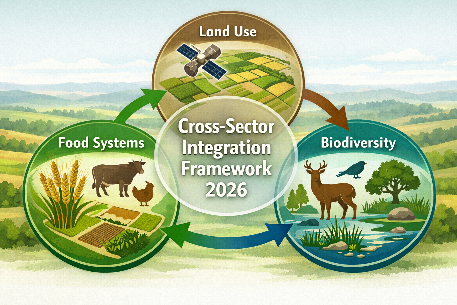
Understanding Integrated Cross-Sector Biodiversity Surveys: Why Food Systems and Land Use Must Shape 2026 Ecology Fieldwork
An integrated cross-sector biodiversity survey goes beyond species lists and habitat classifications. It systematically documents the interactions between ecological communities and the food production, land management, and development systems that shape them.
Core Components of Integration
1. Food System Documentation
Modern biodiversity surveys must record:
- Agricultural practices: crop types, rotation schedules, pesticide and fertilizer regimes
- Livestock management: grazing intensity, stocking densities, seasonal patterns
- Food production infrastructure: irrigation systems, drainage networks, storage facilities
- Supply chain connections: where products go, what inputs arrive, seasonal labor patterns
2. Land Use Pattern Analysis
Rather than treating survey sites as isolated units, integrated approaches map:
- Land use mosaics: the spatial arrangement of different land uses across landscapes
- Management boundaries: ownership patterns, tenure arrangements, management agreements
- Temporal dynamics: seasonal changes, crop cycles, fallow periods
- Connectivity features: hedgerows, field margins, corridors linking habitats
3. Multi-Stakeholder Engagement
Effective integration requires input from:
- Farmers and land managers who understand site history and management
- Developers planning future land use changes
- Landowners making strategic decisions about land management
- Conservation practitioners implementing habitat restoration
- Local communities dependent on ecosystem services
The Biodiversity-Food-Land Use Nexus
The horizon scan emphasizes the need for integrated approaches that recognize the interdependence of climate, biodiversity, water, and human wellbeing.[1] In practice, this means:
| Traditional Approach | Integrated 2026 Approach |
|---|---|
| Survey a woodland fragment | Survey woodland plus adjacent farmland, document agricultural practices affecting woodland edge ecology |
| Count farmland bird species | Map bird populations against crop types, pesticide use, and field margin management |
| Assess wetland plant communities | Analyze wetland ecology in context of upstream land use, agricultural runoff, and water extraction patterns |
| Document pollinator diversity | Connect pollinator populations to crop pollination services, flowering resource availability across seasons, and pesticide exposure risks |
Designing Fieldwork for Cross-Sector Integration
Implementing Integrated Cross-Sector Biodiversity Surveys: Why Food Systems and Land Use Must Shape 2026 Ecology Fieldwork requires methodological shifts in survey design, data collection, and analysis.
Pre-Survey Planning and Stakeholder Mapping
Before fieldwork begins, integrated surveys require:
Landscape Context Analysis
- Review satellite imagery to understand land use patterns across the broader landscape
- Identify key land managers, farmers, and stakeholders
- Research local agricultural systems, crop calendars, and management traditions
- Assess existing biodiversity data and identify gaps
Stakeholder Engagement
- Contact farmers and land managers to understand current and planned practices
- Discuss survey objectives and how data will be used
- Arrange access permissions and coordinate timing with agricultural activities
- Identify local ecological knowledge that can inform survey design
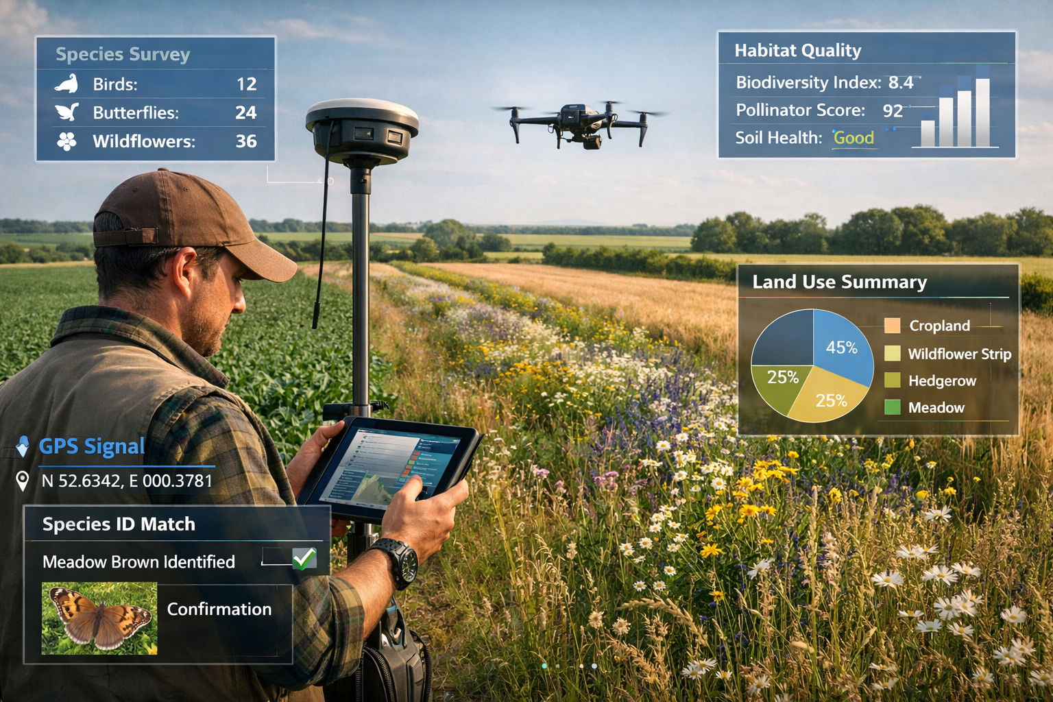
Hybrid Technology-Field Science Approaches
NatureServe and other leading organizations are adopting combined approaches pairing advanced technologies—drones, next-generation remote sensing, acoustic monitoring, and eDNA—with the irreplaceable expertise of field biologists and taxonomists.[2] This hybrid model offers several advantages:
🛰️ Remote Sensing and Drone Technology
- Map land use patterns and habitat structure across large areas
- Monitor vegetation health and crop conditions
- Detect land use changes between survey periods
- Identify priority areas for detailed ground surveys
Early pilot analyses using remote sensing revealed new development since the last field survey in approximately 4% of over 300,000 documented locations of species and ecosystems.[2] This finding highlights how technology can flag changes requiring field verification.
🧬 Environmental DNA (eDNA) Sampling
- Detect species presence without direct observation
- Survey aquatic communities through water samples
- Monitor soil biodiversity in agricultural systems
- Assess impacts of agricultural runoff on downstream ecosystems
🎤 Acoustic Monitoring
- Record bird and bat activity patterns across seasons
- Document temporal changes in species activity related to agricultural cycles
- Monitor pollinator activity in relation to crop flowering periods
- Assess noise pollution impacts from agricultural machinery
👁️ Traditional Field Expertise
- Verify technology-detected patterns through direct observation
- Identify species and assess population health
- Document habitat quality indicators not visible in remote data
- Engage with land managers to understand management history
Data Collection Protocols
Integrated surveys require expanded data collection beyond traditional ecological parameters:
Ecological Variables
- Species composition and abundance
- Habitat structure and quality
- Population demographics
- Ecosystem function indicators
Agricultural Variables
- Crop types and varieties
- Planting and harvest dates
- Pesticide and fertilizer applications
- Irrigation and drainage systems
- Livestock types and stocking rates
Land Use Variables
- Current land use classification
- Management intensity
- Recent land use changes
- Planned future changes
- Ownership and tenure arrangements
Socio-Economic Variables
- Farm business models
- Market connections
- Labor patterns
- Economic constraints and opportunities
- Conservation scheme participation
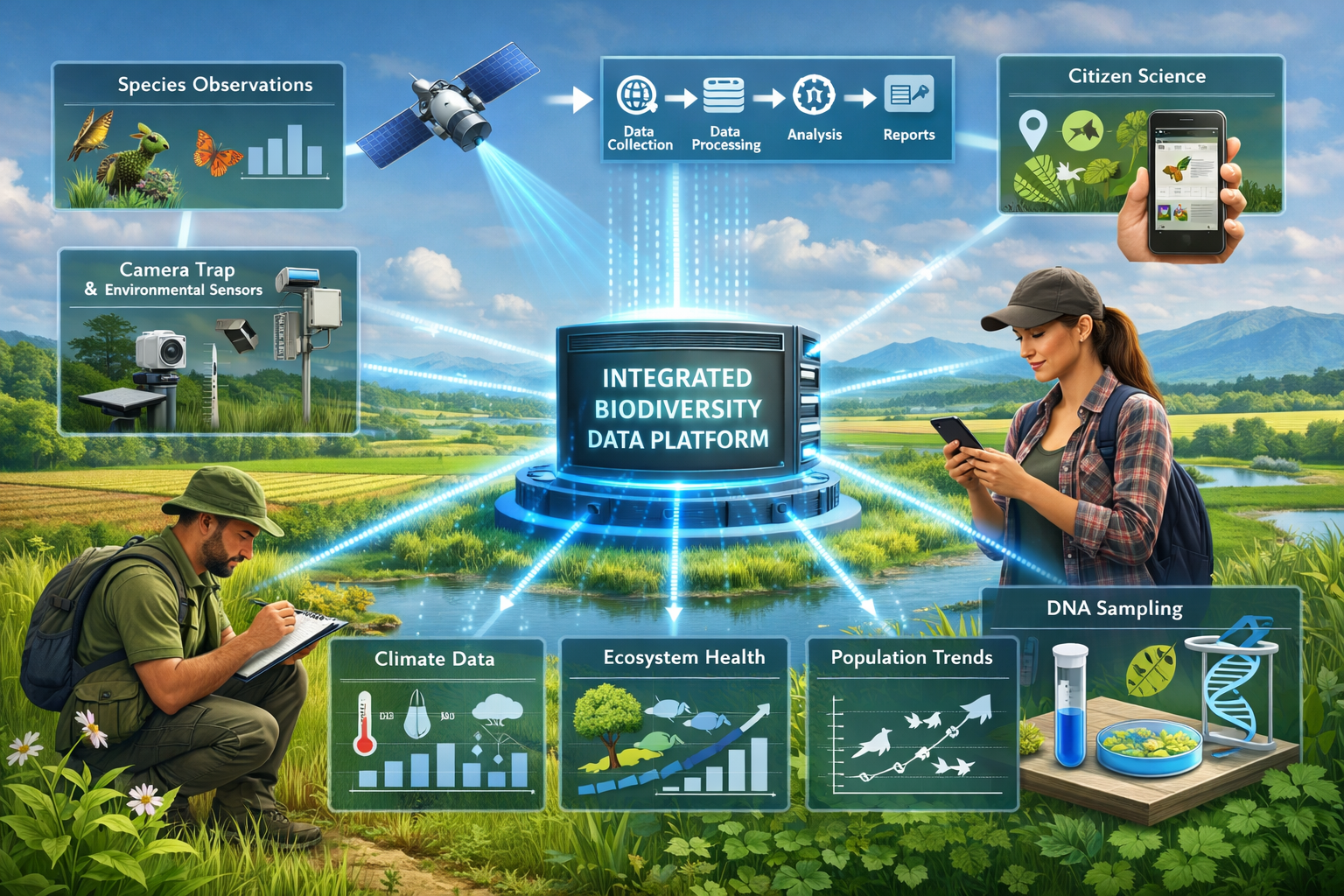
Building Standardized Biodiversity Observation Networks
Europe is leading the development of standardized monitoring frameworks that can integrate diverse data sources. A roadmap led by the University of Amsterdam, German Center for Integrative Biodiversity Research, and Martin Luther University proposes building a Biodiversity Observation Network (BON) for Europe with 84 biodiversity variables.[3]
The 84 Essential Biodiversity Variables
The proposed European framework identifies variables across multiple categories:
Genetic Composition
- Genetic diversity within populations
- Gene flow between populations
- Inbreeding and genetic health
Species Populations
- Species distribution
- Species abundance
- Population structure and demographics
Species Traits
- Functional traits
- Phenology (timing of life cycle events)
- Morphological characteristics
Community Composition
- Taxonomic diversity
- Community structure
- Trophic interactions
Ecosystem Structure
- Habitat extent and distribution
- Ecosystem fragmentation
- Live cover fraction
Ecosystem Function
- Primary productivity
- Nutrient cycling
- Decomposition rates
Data Pipeline Integration
The European BON framework includes data pipelines that integrate professional field notes, citizen science reports, electronic sensors, DNA samples, and satellite images into unified, scalable datasets.[3] This integration addresses a critical challenge: currently, biodiversity data exists in incompatible formats across fragmented systems.
For practitioners conducting biodiversity net gain assessments, standardized variables enable:
- Comparison of baseline conditions across sites
- Consistent monitoring of habitat creation and enhancement
- Verification of biodiversity unit delivery
- Integration with national and international monitoring networks
Practical Applications: From Survey to Action
Case Study: Agricultural Landscape Assessment
Consider a typical 2026 integrated survey scenario: assessing biodiversity across a 500-hectare agricultural landscape in England where a developer is creating a biodiversity plan.
Traditional Approach Limitations
A conventional survey would document species on the development footprint, calculate baseline biodiversity units, and propose on-site mitigation. However, this misses:
- How surrounding agricultural practices affect species populations
- Seasonal resource availability across the landscape
- Connectivity between habitat patches
- Opportunities for landscape-scale enhancement
Integrated Cross-Sector Approach
The integrated survey would:
- Map the landscape mosaic: Document crop types, field boundaries, hedgerows, woodlands, and watercourses across the entire 500 hectares
- Engage farmers: Interview land managers about rotations, pesticide use, conservation schemes, and future plans
- Deploy hybrid monitoring: Use drones for habitat mapping, acoustic recorders for bird and bat surveys, eDNA for aquatic communities, plus traditional field transects
- Document food system connections: Understand what crops are grown, where they're sold, what inputs are used, and how management might change
- Assess landscape connectivity: Map movement corridors for priority species and identify barriers to dispersal
- Model future scenarios: Project how different development and agricultural management scenarios would affect biodiversity
This approach enables achieving biodiversity net gain through landscape-scale solutions rather than site-specific fixes.
Opportunities for Landowners and Developers
The shift toward integrated surveys creates new opportunities:
For Landowners
- Demonstrate biodiversity value of agricultural land for selling biodiversity units
- Access new revenue streams through habitat banking
- Participate in the Sustainable Farming Incentive with robust baseline data
- Improve farm sustainability credentials for market access
For Developers
- Identify off-site biodiversity net gain opportunities early in planning
- Reduce project risks through comprehensive baseline assessment
- Demonstrate corporate biodiversity commitments to stakeholders
- Buy biodiversity units with confidence in their ecological validity
Policy Drivers and Regulatory Context
Federal Capacity Shifts and Partnership Models
NatureServe notes that federal capacity and funding shifts in 2025 were significant, with agencies being encouraged to leverage partnerships outside government.[2] This shift requires increased collaboration between state, regional, NGO, and corporate partners in 2026.
For ecology practitioners, this means:
- Greater emphasis on standardized, shareable data
- Increased private sector involvement in biodiversity monitoring
- Need for data platforms that serve multiple stakeholders
- Opportunities for innovative public-private partnerships
International Policy Momentum
UNEP-WCMC launched a Nature for Development Focal Initiative focused on helping countries place nature and nature's contribution to human wellbeing at the center of development choices, with work addressing food systems, forest economies, and climate-linked risks.[1]
The International Sustainability Standards Board (ISSB) is developing nature-related standards drawing on the Taskforce on Nature-related Financial Disclosures (TNFD) framework.[8] This corporate reporting infrastructure will drive demand for robust, integrated biodiversity data.
European Progress and Targets
The European Commission reports the EU is on track to achieve 16 out of 45 biodiversity targets, though faster action is required.[6] This mixed progress highlights the urgency of improved monitoring and integrated approaches that can accelerate conservation outcomes.
Overcoming Implementation Challenges
Data Complexity and Management
Integrated surveys generate vastly more data than traditional approaches. Managing this complexity requires:
Robust Data Systems
- Cloud-based platforms for field data collection
- Standardized taxonomies and classification systems
- Quality control protocols for diverse data types
- Secure storage with appropriate access controls
Analytical Capacity
- GIS expertise for spatial analysis
- Statistical skills for complex datasets
- Ecological modeling capabilities
- Cross-disciplinary interpretation skills
Cost and Resource Considerations
Integrated surveys require greater upfront investment than traditional approaches. However, they deliver:
Enhanced Value
- Data usable for multiple purposes (planning, monitoring, reporting)
- Reduced need for repeat surveys
- Better targeting of conservation interventions
- Improved outcomes reducing long-term costs
Efficiency Gains
- Technology reduces field time for some tasks
- Standardized protocols reduce training needs
- Shared data platforms reduce duplication
- Partnerships spread costs across stakeholders
Skills and Training Needs
Ecologists conducting integrated surveys need expanded skillsets:
- Technology proficiency: drone operation, remote sensing interpretation, eDNA protocols
- Cross-sector knowledge: agricultural systems, land use planning, food supply chains
- Stakeholder engagement: farmer interviews, participatory mapping, conflict resolution
- Data science: database management, spatial analysis, statistical modeling
- Systems thinking: understanding complex interactions and feedback loops
The Path Forward: Actionable Steps for 2026
For Ecology Practitioners
✅ Expand survey scope: Begin incorporating land use and agricultural practice documentation into standard protocols
✅ Invest in technology: Acquire or partner for access to drones, acoustic recorders, and eDNA capabilities
✅ Build partnerships: Establish relationships with farmers, land managers, and agricultural advisors
✅ Standardize data: Adopt emerging frameworks like the European BON variables where applicable
✅ Enhance skills: Pursue training in GIS, remote sensing, and cross-sector ecological assessment
For Landowners and Farmers
✅ Engage with surveyors: Share management information and local ecological knowledge
✅ Document practices: Maintain records of agricultural activities that affect biodiversity
✅ Explore opportunities: Investigate biodiversity unit sales, conservation schemes, and habitat banking
✅ Plan strategically: Consider how integrated biodiversity data can inform farm business decisions
For Developers and Planners
✅ Commission integrated assessments: Request surveys that document landscape context and food system connections
✅ Engage early: Begin biodiversity assessment at initial land evaluation stages
✅ Think landscape-scale: Look beyond site boundaries for biodiversity net gain solutions
✅ Build partnerships: Work with agricultural landowners on landscape-scale biodiversity enhancement
Conclusion
The recognition that Integrated Cross-Sector Biodiversity Surveys: Why Food Systems and Land Use Must Shape 2026 Ecology Fieldwork represents more than a methodological refinement—it signals a fundamental shift in how we understand and address biodiversity loss. The 2026 Global Horizon Scan's identification of food systems as a critical conservation issue, combined with surging corporate demand for biodiversity risk data and emerging standardized monitoring networks, creates both urgency and opportunity for this transformation.
Traditional ecology surveys, focused on isolated sites and species lists, cannot capture the complex interactions between food production, land management, and ecological health that determine whether biodiversity persists or declines. As we move through 2026, the evidence is clear: reversing biodiversity loss requires integrated efforts spanning conservation, agriculture, and even dietary change.
For ecology practitioners, this means embracing hybrid approaches that combine cutting-edge technology with irreplaceable field expertise, expanding skillsets to include agricultural systems and stakeholder engagement, and adopting standardized frameworks that enable data sharing across sectors and scales.
For landowners, developers, and planners, integrated surveys offer more robust baseline data, landscape-scale solutions, and new opportunities for biodiversity enhancement that align conservation with productive land use.
The path forward requires collaboration, investment in new capabilities, and willingness to work across traditional boundaries. But the alternative—continuing with siloed approaches that miss critical ecological connections—is no longer viable. The biodiversity crisis of 2026 demands nothing less than fully integrated, cross-sector assessment that places ecological health at the center of land use decision-making.
The question is not whether to integrate food systems and land use into ecology fieldwork, but how quickly we can make this transformation standard practice. Those who embrace integrated approaches now will lead the field, deliver superior outcomes, and contribute meaningfully to reversing biodiversity decline.
References
[1] Whats Next For Biodiversity Conservation Insights From The 2026 Horizon Scan – https://www.unep-wcmc.org/en/news/whats-next-for-biodiversity-conservation-insights-from-the-2026-horizon-scan
[2] Natureserve Highlights Growing Biodiversity Risks Amid Shifting Conservation – https://www.natureserve.org/news-releases/natureserve-highlights-growing-biodiversity-risks-amid-shifting-conservation
[3] 2026 02 Roadmap Outlines Biodiversity Variables Europe – https://phys.org/news/2026-02-roadmap-outlines-biodiversity-variables-europe.html
[5] Intergovernmental Science Policy Platform Biodiversity Ecosystem Services Ipbes12 Summary – https://enb.iisd.org/intergovernmental-science-policy-platform-biodiversity-ecosystem-services-ipbes12-summary
[6] Progress Made Biodiversity Swifter Action Needed 2026 02 12 En – https://environment.ec.europa.eu/news/progress-made-biodiversity-swifter-action-needed-2026-02-12_en
[8] Issb Decision On Nature Related Standard Setting Drawing On Tnfd Framework – https://tnfd.global/issb-decision-on-nature-related-standard-setting-drawing-on-tnfd-framework/
