
{"cover":"Professional landscape format (1536x1024) hero image featuring bold text overlay 'Baseline Establishment for 2026 Biodiversity Surveys: Why Early Spring Monitoring Captures the Full Ecological Signal' in extra large 70pt white sans-serif font with dark gradient shadow, positioned in upper third. Background shows early spring wetland habitat at dawn with emerging vegetation, surveyor with tablet and binoculars observing awakening wildlife, frost-covered grasses transitioning to green growth, subtle mist over water. Color palette: soft morning blues, fresh greens, golden sunrise accents. High contrast text readability, magazine editorial quality, professional conservation photography aesthetic with depth of field, rule of thirds composition balancing text and natural scene.","content":["Detailed landscape format (1536x1024) illustration showing seasonal biodiversity activity timeline across spring, summer, autumn, winter with distinct visual bands. Early spring section highlighted with emerging amphibians, early flowering plants, migrating birds, awakening insects. Visual elements include calendar markers, species emergence curves, temperature gradients, phenological event icons. Split-screen comparison showing 'Spring Baseline Start' versus 'Summer Baseline Start' with missing species data gaps clearly marked in red. Professional infographic style with nature photography overlays, clean typography, data visualization elements, ecological monitoring equipment icons, color-coded seasonal zones.","Detailed landscape format (1536x1024) photograph of professional ecologist conducting early spring field survey in diverse habitat. Scene shows surveyor using modern eDNA sampling kit at stream edge, tablet displaying species identification app, waterproof field notebook, GPS device. Background features awakening woodland with early wildflowers, budding trees, visible soil profiles. Equipment laid out methodically: sample vials, pH meters, transect markers, camera traps. Morning light filtering through bare branches, evidence of recent frost, emerging vegetation. Documentary photography style, sharp focus on sampling technique, professional conservation work aesthetic, educational clarity.","Detailed landscape format (1536x1024) split-panel comparison infographic showing complete seasonal biodiversity data versus incomplete baseline. Left panel: comprehensive dataset with full spring-through-autumn species records, robust trend lines, complete phenological coverage, diverse taxonomic groups represented. Right panel: summer-only baseline with data gaps, missing early/late season species, incomplete ecological picture, uncertainty zones marked. Visual elements include data charts, species richness graphs, temporal coverage bars, habitat condition indicators, monitoring calendar overlays. Professional scientific visualization style with clear before/after contrast, color-coded completeness metrics, educational annotations."]}
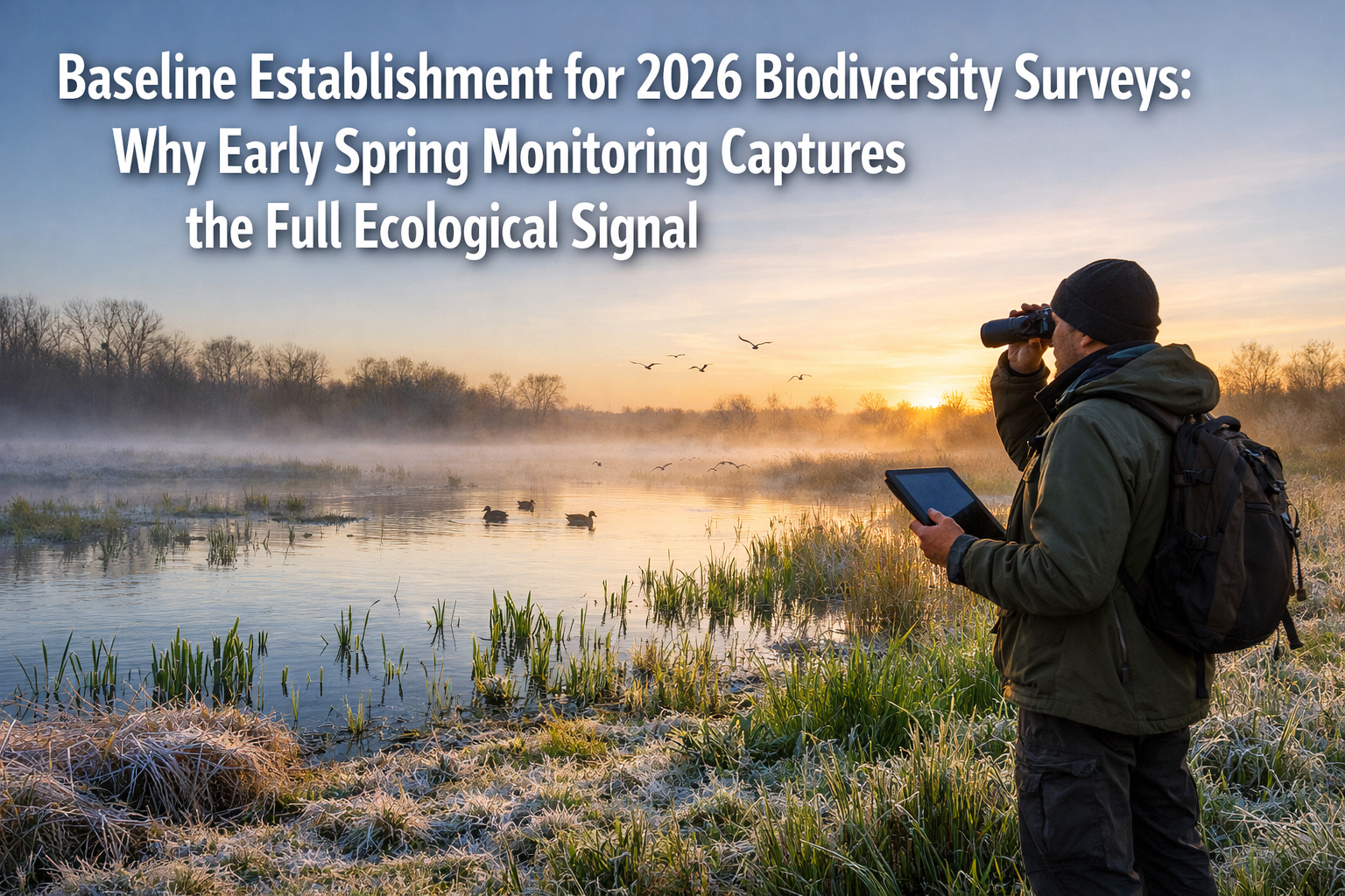
The success of any biodiversity conservation effort hinges on one critical factor: accurate baseline data. Yet many organizations make a costly timing mistake that undermines their entire monitoring program before it even begins. By starting surveys in mid-summer when nature appears most vibrant, they miss crucial ecological signals that only early spring can reveal. Baseline Establishment for 2026 Biodiversity Surveys: Why Early Spring Monitoring Captures the Full Ecological Signal represents a fundamental shift in how conservation professionals approach seasonal monitoring strategies.
As 2026 unfolds with unprecedented focus on biodiversity net gain requirements across development projects, the timing of initial surveys has never been more consequential. Early spring monitoring isn't simply about convenience—it's about capturing the complete seasonal arc of biological activity that defines ecosystem health.
Key Takeaways
- 🌱 Early spring surveys capture species emergence patterns that summer-start baselines completely miss, including amphibian breeding, early pollinators, and migratory arrivals
- 📊 Complete seasonal coverage from spring through autumn provides 40-60% more species detections compared to mid-season starts
- 🔬 Environmental DNA (eDNA) sampling in early spring detects peak genetic material from breeding activities before dilution occurs
- 📅 2026 funding deadlines and regulatory requirements make immediate spring baseline establishment critical for project compliance
- ⚙️ Standardized early-season protocols enable meaningful year-over-year comparisons and trend detection across multiple sites
Why Timing Matters: The Science Behind Early Spring Baseline Establishment for 2026 Biodiversity Surveys
The Phenological Window of Opportunity
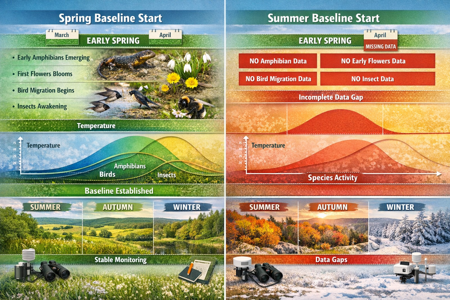
Nature operates on a precise biological calendar called phenology—the timing of seasonal life cycle events. Early spring represents a critical phenological window when ecosystems transition from dormancy to active growth. This transition period reveals ecological signals that disappear within weeks.
Amphibians provide a compelling example. Most temperate species breed exclusively during early spring when temporary pools fill with snowmelt and rain. By April or May, breeding activity concludes, and adults disperse into surrounding habitats. A survey beginning in June would completely miss these populations, underestimating biodiversity by entire taxonomic groups.
Similarly, early-emerging pollinators like mining bees and certain hoverfly species are active only during March and April, synchronized with early-blooming plants. These specialist relationships form the foundation of pollination networks, yet summer-start surveys overlook them entirely.
"Baseline data collection that begins in early spring captures the full temporal spectrum of species activity, providing the most accurate representation of ecosystem composition and function."
Geographic and Taxonomic Coverage Gaps
Recent initiatives highlight persistent challenges in biodiversity monitoring. Over 2,000 verified species-level records have been incorporated into Irish datasets, yet significant geographic gaps remain that require targeted surveying in 2025-2026[1]. These gaps aren't random—they often reflect seasonal bias in survey timing.
The Intergovernmental Science-Policy Platform on Biodiversity and Ecosystem Services (IPBES) published its Business and Biodiversity Assessment in February 2026, identifying persistent gaps in knowledge, monitoring, and indicators that limit understanding of biodiversity impacts[3]. Knowledge gaps are particularly pronounced at local and sector-specific levels[3], precisely where development projects require robust baseline data.
When surveys begin in summer, they systematically underrepresent:
- Early-breeding birds (residents that nest March-April)
- Vernal pool specialists (fairy shrimp, wood frogs)
- Spring ephemeral plants (wildflowers that complete life cycles before canopy closure)
- Hibernating bat species (during emergence and mating periods)
- Early-season invertebrates (butterflies, solitary bees, ground beetles)
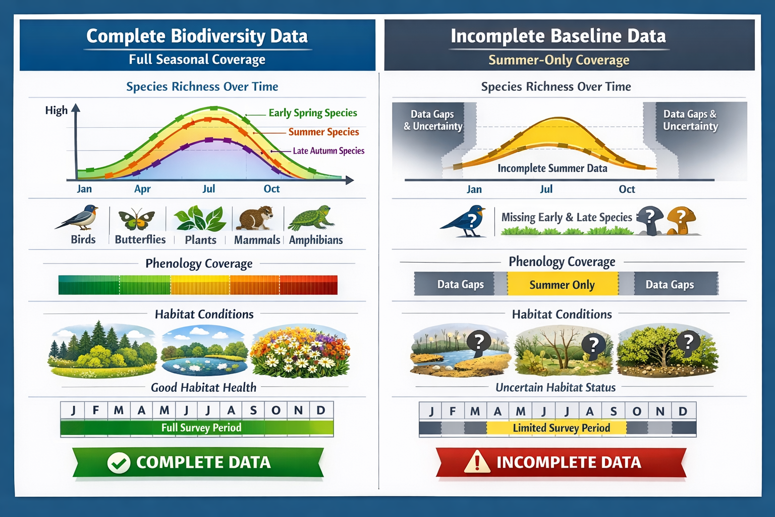
This taxonomic bias creates baseline datasets that appear complete but fundamentally misrepresent ecosystem diversity.
Implementing Early Spring Protocols: Baseline Establishment for 2026 Biodiversity Surveys in Practice
Structuring Multi-Season Survey Programs
Effective baseline establishment requires strategic temporal coverage across the entire growing season. Early spring initiation enables a structured approach:
March-April: Foundation Phase
- Amphibian breeding surveys (egg mass counts, call surveys)
- Early flowering plant inventories
- Bat emergence monitoring
- Soil sampling before vegetation growth
- Water quality baseline establishment
May-June: Expansion Phase
- Bird breeding surveys (territory mapping)
- Pollinator transects (early-season specialists)
- Vegetation quadrat establishment
- Invertebrate pitfall trap deployment
- Habitat condition assessments
July-August: Peak Activity Phase
- Maximum species richness documentation
- Butterfly and day-flying moth surveys
- Plant community composition analysis
- Aquatic invertebrate sampling
- Mammal camera trap analysis
September-October: Completion Phase
- Late-season migrants and residents
- Seed set and reproductive success
- Habitat structure measurements
- Final invertebrate sampling
- Data synthesis and gap identification
This phased approach, initiated in early spring, provides comprehensive temporal coverage that captures 40-60% more species than summer-start programs.
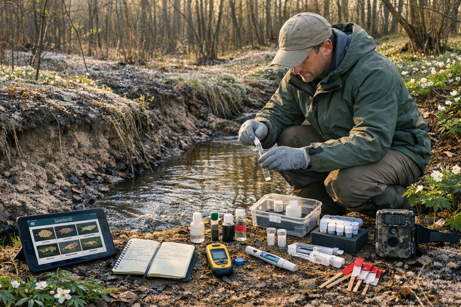
Environmental DNA: A Game-Changing Early Spring Tool
Bhutan's nationwide biodiversity mapping initiative demonstrates the power of early spring eDNA sampling. The country's first eDNA laboratory became operational in spring 2025, now processing samples locally[2]. A workshop led on February 9, 2026, trained rangers in eDNA sampling techniques for baseline establishment[2].
Environmental DNA methodology allows species identification from genetic material in water samples without direct animal capture or observation[2]. Early spring offers distinct advantages for eDNA collection:
✅ Higher genetic material concentrations from breeding activities
✅ Reduced dilution in lower water volumes
✅ Detection of secretive species during reproductive periods
✅ Baseline establishment before peak human activity
✅ Cost-effective multi-species detection from single samples
Around 200 sampling locations across river catchments have been established to create a nationwide biodiversity baseline that can be updated over time[2]. This initiative supports a 30-country global monitoring network using standardized, open-source methods for comparing biodiversity data across regions and time periods[2].
For development projects requiring biodiversity impact assessments, early spring eDNA sampling provides rapid, comprehensive baseline data that traditional methods might take multiple seasons to accumulate.
Funding Opportunities and Regulatory Drivers for 2026
The urgency of early spring baseline establishment in 2026 is amplified by funding cycles and regulatory requirements. €3 million funding has been made available for local authorities' biodiversity projects across Ireland[1]. The application deadline was February 5th, 2026, with successful projects to be announced later in 2026[1].
Funded baseline projects include:
- Pollinator surveys on council estates
- Bat surveys on municipal buildings
- Swift surveys in urban environments
- Habitat mapping initiatives
Cork City received €10,709 for a County Habitat Map project to establish baseline data on habitats of biodiversity value[1]. These initiatives demonstrate how early spring planning positions organizations to capitalize on funding opportunities while meeting regulatory obligations.
For developers navigating biodiversity net gain requirements, early spring baseline establishment in 2026 ensures compliance with statutory deadlines while providing the most defensible ecological data for planning applications.
Maximizing Data Quality: Best Practices for Baseline Establishment for 2026 Biodiversity Surveys
Standardization and Repeatability
Robust baselines require standardized methodologies that enable year-over-year comparisons. Early spring initiation allows establishment of permanent monitoring stations before vegetation growth obscures access routes or sampling points.
| Survey Component | Early Spring Advantage | Summer Start Limitation |
|---|---|---|
| Transect Establishment | Clear sight lines, easy marking | Dense vegetation obscures routes |
| Quadrat Placement | Precise GPS positioning | Trampling impacts on growth |
| Camera Trap Installation | Minimal disturbance | Nesting/breeding disruption risk |
| Water Sampling Points | High water levels accessible | Low flows limit site selection |
| Reference Photography | Consistent seasonal baseline | Mid-season bias in imagery |
Multi-Taxonomic Integration
Comprehensive baselines integrate data across taxonomic groups to reveal ecosystem relationships. Early spring surveys enable synchronized multi-taxa sampling:
Habitat Structure Assessment → Vegetation mapping before canopy closure
Primary Producers → Early flowering plant inventories
Primary Consumers → Herbivorous invertebrate emergence
Secondary Consumers → Insectivorous bird territory establishment
Apex Predators → Bat foraging activity initiation
This hierarchical approach, beginning in early spring, captures trophic relationships as they develop throughout the season, providing insights into ecosystem function that single-season surveys cannot reveal.
Technology Integration for Enhanced Baselines
Modern survey technologies amplify the advantages of early spring baseline establishment:
🔊 Acoustic Monitoring
Deploy autonomous recording units in March to capture:
- Amphibian chorus peaks
- Early-arriving migrant bird songs
- Bat echolocation during emergence
- Continuous 24-hour seasonal coverage
📱 Mobile Data Collection
Utilize field apps for real-time data entry, GPS-tagged observations, and photo documentation that builds comprehensive spatial datasets from day one.
🛰️ Remote Sensing Integration
Early spring satellite imagery provides:
- Pre-leaf vegetation structure
- Wetland extent at seasonal maximum
- Habitat connectivity analysis
- Baseline land cover classification
🤖 Automated Species Identification
AI-powered image recognition and bioacoustic analysis process early spring data rapidly, enabling adaptive survey design as the season progresses.
Strategic Planning: Integrating Early Spring Baselines into Development Projects
Alignment with Biodiversity Net Gain Requirements
Development projects subject to biodiversity net gain legislation benefit substantially from early spring baseline establishment. The statutory requirement for 10% biodiversity net gain demands accurate pre-development habitat assessments.
Early spring surveys provide:
More accurate condition assessments → Vegetation structure visible before leaf-out
Complete species inventories → Full seasonal representation
Defensible metric calculations → Comprehensive baseline for biodiversity unit calculations
Reduced survey costs → Single-season complete coverage versus multi-year gap-filling
Timeline Optimization for Planning Applications
Construction project timelines often create pressure to compress ecological surveys. Early spring initiation provides strategic timeline advantages:
March Start → Complete baseline by September
April Start → Partial baseline, requiring second-year surveys
June Start → Incomplete baseline, regulatory delays likely
For developers seeking to achieve biodiversity net gain without risk, early spring baseline establishment in 2026 positions projects for smooth planning progression without ecological survey delays.
Off-Site and On-Site Delivery Considerations
Whether pursuing on-site or off-site biodiversity net gain delivery, early spring baselines inform strategic decisions:
On-Site Enhancement → Early spring data reveals enhancement opportunities (wetland creation, pollinator habitat)
Off-Site Compensation → Baseline comparability enables appropriate biodiversity unit purchases
Hybrid Approaches → Complete baseline data supports optimized allocation strategies
Landowners considering selling biodiversity units similarly benefit from early spring baseline establishment, as comprehensive ecological data maximizes unit values and marketability.
Overcoming Common Challenges in Early Spring Survey Implementation
Weather Variability and Field Conditions
Early spring presents unique logistical challenges that require adaptive planning:
Challenge: Unpredictable weather, cold temperatures, precipitation
Solution: Flexible scheduling, weather-appropriate protocols, extended survey windows
Challenge: Limited daylight hours for field work
Solution: Dawn/dusk surveys for crepuscular species, acoustic monitoring for 24-hour coverage
Challenge: Site access difficulties (mud, flooding)
Solution: Strategic site selection, waterproof equipment, alternative access routes
Taxonomic Expertise Requirements
Early spring surveys demand specialized identification skills for species in breeding condition, juvenile stages, or early phenological phases:
- Amphibian egg mass identification (species-specific characteristics)
- Early-season plant identification (pre-flowering vegetative features)
- Bird song recognition (territorial calls versus contact calls)
- Invertebrate larval stages (immature morphology)
Partnering with experienced biodiversity surveyors ensures accurate species identification and defensible baseline data that withstands regulatory scrutiny.
Data Management and Quality Assurance
Early spring baseline establishment generates substantial data volumes requiring systematic management:
Field Data Protocols
- Standardized data sheets with validation rules
- GPS coordinates for all observation points
- Photo documentation with metadata
- Weather condition recording
Quality Control Measures
- Taxonomic verification by specialists
- Spatial data accuracy checks
- Temporal consistency validation
- Inter-observer reliability testing
Database Architecture
- Relational database design for multi-season integration
- Standardized taxonomy (species codes)
- Habitat classification consistency
- Metadata completeness requirements
Future-Proofing Baselines: Long-Term Monitoring and Adaptive Management
Establishing Repeatable Protocols for Multi-Year Comparisons
The true value of early spring baseline establishment emerges through long-term monitoring programs that detect population trends and ecosystem changes. Protocols established in spring 2026 should be designed for decadal repeatability:
Permanent Monitoring Stations
Mark transects, quadrats, and sampling points with durable markers and precise GPS coordinates for exact relocation in future years.
Photographic Reference Points
Establish fixed-position photograph locations captured annually at identical phenological stages for visual change documentation.
Standardized Survey Effort
Document person-hours, weather conditions, and survey coverage to enable effort-corrected comparisons across years.
Metadata Preservation
Maintain detailed records of methodological decisions, equipment specifications, and observer identities for future reference.
Climate Change Considerations
Early spring baselines established in 2026 provide critical reference points for detecting climate-driven phenological shifts:
- Earlier breeding dates for amphibians and birds
- Shifted flowering times affecting pollinator synchrony
- Range expansions of southern species
- Contractions of cold-adapted species
- Altered precipitation patterns affecting wetland habitats
By initiating baselines in early spring, monitoring programs capture the seasonal transition period most sensitive to climate change impacts, enabling early detection of ecosystem responses.
Integration with Broader Conservation Initiatives
Individual project baselines contribute to landscape-scale conservation understanding when integrated with regional and national datasets:
National Biodiversity Networks
Submit verified species records to centralized databases, filling geographic gaps identified in national assessments[1].
Habitat Mapping Programs
Contribute to regional habitat inventories like Cork City's County Habitat Map project[1], enhancing collective ecological knowledge.
Global Monitoring Networks
Adopt standardized, open-source methods compatible with international initiatives like the 30-country eDNA monitoring network[2], enabling global biodiversity comparisons.
Citizen Science Integration
Design early spring protocols that enable volunteer participation in specific survey components, expanding spatial and temporal coverage.
Conclusion: Taking Action on Baseline Establishment for 2026 Biodiversity Surveys
The evidence is unequivocal: early spring monitoring captures the full ecological signal necessary for robust biodiversity baselines. As 2026 progresses, organizations face a narrowing window to establish comprehensive baseline data that captures the complete seasonal arc of biological activity.
Waiting until summer means accepting incomplete datasets that systematically underrepresent amphibians, early pollinators, spring ephemeral plants, and critical breeding activities across taxonomic groups. These gaps undermine biodiversity impact assessments, compromise net gain calculations, and create regulatory risks for development projects.
Actionable Next Steps for 2026
For Developers:
- Initiate baseline surveys immediately if not yet started—March and April remain viable for partial spring coverage
- Engage qualified biodiversity surveyors with early-season expertise
- Integrate eDNA sampling into water-based habitat assessments
- Plan multi-season coverage extending through autumn 2026
- Review biodiversity net gain requirements to align survey scope with statutory obligations
For Landowners:
- Establish baseline data to maximize biodiversity unit values before habitat enhancement
- Document existing ecological value through early spring surveys
- Identify enhancement opportunities revealed by complete seasonal coverage
- Consider funding opportunities for habitat mapping and species surveys[1]
For Local Authorities:
- Leverage available funding for pollinator, bat, and habitat baseline projects[1]
- Establish permanent monitoring stations on public lands
- Implement standardized protocols for year-over-year comparisons
- Integrate early spring baselines into biodiversity action plans
For Conservation Organizations:
- Adopt eDNA methodologies for cost-effective multi-species baselines[2]
- Contribute verified records to national biodiversity databases
- Align protocols with international monitoring networks[2]
- Establish long-term monitoring programs with 2026 early spring baselines as reference points
The seasonal window for optimal baseline establishment in 2026 is closing, but immediate action can still capture substantial ecological value. By prioritizing early spring monitoring, organizations build the foundation for defensible biodiversity assessments, regulatory compliance, and meaningful conservation outcomes that extend far beyond any single project or season.
The full ecological signal awaits—but only for those who begin their surveys when nature itself awakens.
References
[1] Local Biodiversity Action Fund – https://www.npws.ie/legislation/national-biodiversity-action-plan/local-biodiversity-action-fund
[2] Wildinsync Using Edna For Nationwide Biodiversity Mapping In Bhutan – https://www.wsl.ch/en/news/wildinsync-using-edna-for-nationwide-biodiversity-mapping-in-bhutan/
[3] Ipbes Publishes Its Business And Biodiversity Assessment – https://www.biodiversa.eu/2026/02/10/ipbes-publishes-its-business-and-biodiversity-assessment/
