
The difference between a robust biodiversity baseline and a compromised one often comes down to a single decision: when to start monitoring. As development pressures intensify across the UK and regulatory requirements evolve, the timing of initial surveys determines whether future assessments reveal genuine ecological trends or merely seasonal fluctuations. Early Spring Baseline Establishment in 2026 Biodiversity Surveys: Capturing Full-Season Ecological Rhythms for Accurate Trend Detection represents a critical shift from reactive, peak-season snapshots to comprehensive, year-round ecological understanding that supports accurate conservation outcomes.
Starting biodiversity monitoring in early spring rather than waiting for summer peak activity captures the complete biological activity arc—from initial emergence through seasonal decline. This comprehensive approach provides surveyors with protocols for establishing robust baselines that reveal true ecosystem dynamics rather than isolated seasonal peaks, ensuring that biodiversity impact assessments rest on scientifically sound foundations.
Key Takeaways
- 🌱 Early spring surveys capture complete seasonal arcs rather than isolated peak-season snapshots, providing comprehensive baseline data for accurate long-term trend detection
- 📊 Habitat distinctiveness values can double between seasons, with winter assessments potentially undervaluing sites by 5.8 biodiversity units per hectare compared to spring surveys
- 🎯 Baseline quality determines all future comparisons, making the timing and methodology of initial 2026 surveys critical for decades of subsequent ecological monitoring
- 🔄 Multi-season continuous monitoring distinguishes genuine trends from weather-driven variation, preventing misinterpretation of temporary fluctuations as permanent ecological changes
- ⏰ Starting surveys before regulatory pressure emerges provides time to understand ecosystem complexity rather than merely reacting to compliance deadlines
Why Early Spring Baseline Establishment in 2026 Biodiversity Surveys Matters for Accurate Trend Detection
The Complete Seasonal Arc Problem
Most biodiversity surveys begin when ecological activity becomes obvious—typically during peak summer months when vegetation is fully developed and wildlife activity is most visible. This approach creates a fundamental problem: surveyors miss the critical early-season emergence patterns that define ecosystem health.
Early spring monitoring captures the complete biological activity arc:
- Initial emergence (March-April): Early flowering plants, amphibian breeding, migratory bird arrivals
- Rapid development (April-May): Vegetation growth acceleration, insect emergence, nesting activity
- Peak activity (June-July): Maximum flowering, pollinator abundance, breeding peaks
- Seasonal decline (August-September): Seed production, late-season species, preparation for dormancy
Without early spring data, surveyors see only the middle chapters of the ecological story. This incomplete picture makes it impossible to distinguish between sites with robust early-season diversity and those that merely appear productive during summer peaks.
Baseline Quality Determines Everything
The reference point established when monitoring begins shapes every subsequent ecological assessment for years or even decades. Consider this scenario:
A development site receives its first biodiversity survey in July 2026. The surveyor documents abundant wildflowers, active pollinators, and diverse bird species. This becomes the "baseline" against which all future changes are measured.
The problem? The site may have already experienced significant degradation. Without early spring data from 2026, there's no way to know whether:
- Early-flowering species that once thrived have already disappeared
- Amphibian populations that breed in March-April have declined
- Soil moisture patterns that support spring ephemeral plants have changed
- Early-season pollinators that depend on specific spring flowers are missing
What appears "normal" in July may actually represent an already-compromised ecosystem. Once this flawed baseline is established, future assessments will compare degraded conditions against degraded conditions—making genuine ecological decline invisible.
This challenge directly impacts achieving biodiversity net gain, as calculations based on incomplete baselines systematically undervalue existing ecological assets.
The 2026 Window of Opportunity
Starting comprehensive monitoring in early 2026 offers several strategic advantages:
| Advantage | Description | Impact |
|---|---|---|
| 🌍 Global alignment | Supports UN Kunming-Montreal biodiversity framework implementation | Positions UK projects within international conservation context |
| 📋 Regulatory preparation | Establishes data before potential policy changes | Avoids rushed surveys driven by compliance deadlines |
| 🔬 Methodological refinement | Allows protocol testing and adjustment across seasons | Improves data quality and consistency |
| 💰 Cost efficiency | Spreads survey effort across multiple visits rather than intensive single-season work | Reduces peak-season scheduling conflicts and costs |
| 🎓 Knowledge building | Develops deep site understanding before intervention decisions | Supports better-informed conservation strategies |
Capturing Full-Season Ecological Rhythms: Practical Protocols for 2026 Surveys
Establishing Clear Monitoring Objectives
Before beginning Early Spring Baseline Establishment in 2026 Biodiversity Surveys, organizations must define specific objectives that determine how data will be collected and interpreted:
Baseline Ecosystem Health Understanding
- Goal: Document current conditions without immediate intervention plans
- Approach: Comprehensive species inventories, habitat mapping, condition assessments
- Timeline: Multiple visits across all seasons of 2026
- Output: Detailed ecological profile supporting future decision-making
Management Change Evaluation
- Goal: Assess effects of specific interventions (grazing changes, habitat restoration, etc.)
- Approach: Before-After-Control-Impact (BACI) design with pre-intervention baseline
- Timeline: Early 2026 baseline before intervention, continued monitoring post-intervention
- Output: Quantitative comparison demonstrating intervention effectiveness
Permitting and Reporting Support
- Goal: Meet regulatory requirements for development or conservation projects
- Approach: Standardized survey methods aligned with biodiversity net gain assessment requirements
- Timeline: Season-appropriate surveys following Defra guidance
- Output: Compliant reports supporting planning applications
"Without data across multiple seasons, weather-driven variation can be mistaken for long-term decline, short-term disturbance can appear as recovery, and interventions can seem effective or ineffective simply due to lack of adequate baseline comparison."
Seasonal Survey Timing Protocols
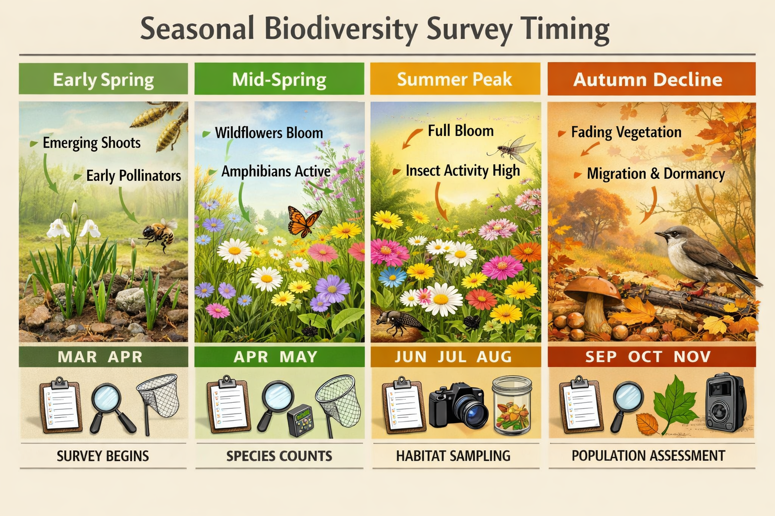
Early Spring Phase (March-April 2026) ❄️➡️🌱
This critical period captures:
- Early flowering species (primrose, lesser celandine, wood anemone)
- Amphibian breeding activity (frogs, toads, newts)
- Early emerging butterflies (brimstone, peacock, comma)
- Migratory bird arrivals (chiffchaff, willow warbler, swallow)
- Bare ground and vegetation structure before canopy closure
Survey methods:
- Habitat condition assessments while vegetation structure is visible
- Amphibian breeding pond surveys
- Early flowering plant inventories
- Breeding bird territory mapping (first visit)
- Soil and moisture condition documentation
Mid-Spring Phase (April-May 2026) 🌱🌸
This rapid-change period documents:
- Rapid vegetation development and species composition emergence
- Peak amphibian activity
- Increased insect emergence
- Bird nesting activity intensification
- Habitat distinctiveness clarification
Survey methods:
- Detailed botanical surveys as species become identifiable
- Invertebrate sampling as populations emerge
- Breeding bird surveys (second visit)
- Habitat mapping refinement based on spring vegetation
- Photographic documentation of seasonal change
Late Spring to Early Summer (May-June 2026) 🌸☀️
This transition period captures:
- Peak flowering for many grassland species
- Maximum pollinator diversity
- Late-arriving migrant species
- Breeding activity peaks
- Habitat condition at optimal assessment time
Survey methods:
- Comprehensive botanical inventories
- Pollinator transect surveys
- Breeding bird surveys (third visit)
- Habitat distinctiveness value confirmation
- Condition assessment scoring
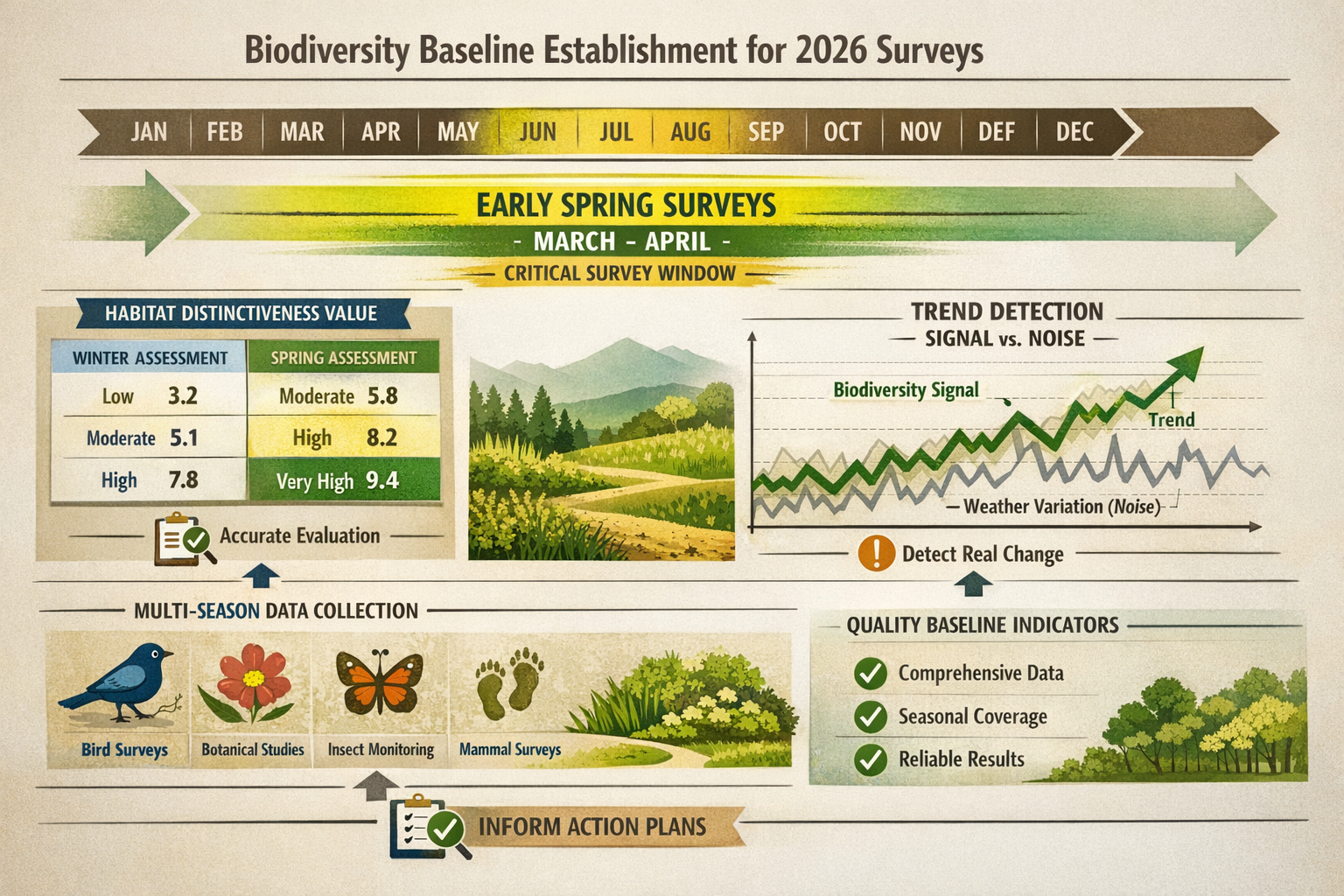
Habitat Distinctiveness: The Seasonal Valuation Challenge
One of the most significant impacts of Early Spring Baseline Establishment in 2026 Biodiversity Surveys relates to habitat distinctiveness values—the foundation of biodiversity metric calculations.
The Winter Assessment Problem:
A surveyor visiting a grassland site in winter might observe:
- Limited visible flowering species
- Dormant vegetation
- Unclear botanical composition
- Minimal invertebrate activity
Based on this limited information, the habitat might be classified as "Other neutral grassland" with a distinctiveness value of 4 out of 8.
The Spring Assessment Revelation:
The same surveyor returning in April-May 2026 might discover:
- Abundant yellow rattle (indicator of low fertility)
- Diverse spring-flowering species (cowslip, bird's-foot trefoil, common knapweed)
- Anthills indicating long-established grassland
- Early-emerging specialist butterflies
This evidence supports reclassification as "Lowland meadows" with a distinctiveness value of 8 out of 8.
The Numerical Impact:
For a 1-hectare site:
- Winter assessment: 1 ha × 4 (distinctiveness) × 2 (good condition) = 8 biodiversity units
- Spring assessment: 1 ha × 8 (distinctiveness) × 2 (good condition) = 16 biodiversity units
Difference: 8 biodiversity units representing substantial ecological and financial value in biodiversity net gain calculations.
This seasonal variation demonstrates why early spring surveys are essential—they reveal habitat quality that winter or late-summer assessments miss entirely.
Distinguishing Signal from Noise: Multi-Season Data Requirements
The Weather Variation Challenge
Single-season surveys face a critical limitation: they cannot distinguish genuine ecological trends from weather-driven fluctuations.
Consider these scenarios:
Scenario 1: The Dry Spring
- Spring 2026 experiences below-average rainfall
- Wetland plants show reduced abundance
- Amphibian breeding success appears low
- Surveyor documents "declining wetland habitat"
Reality: Normal weather variation, not genuine decline. Without multi-year data, temporary drought effects appear as permanent degradation.
Scenario 2: The Late Cold Snap
- Unseasonable frost in April 2026 damages early flowers
- Pollinator surveys show reduced activity
- Assessment suggests "poor habitat for pollinators"
Reality: Temporary weather impact. The habitat structure and plant diversity remain intact, but timing of the survey coincided with weather disruption.
Scenario 3: The Exceptional Year
- Perfect growing conditions in 2026 produce abundant flowering
- Species counts exceed typical levels
- Baseline established at artificially high level
Reality: Future "normal" years will appear as decline when compared against this exceptional baseline.
Multi-Season Monitoring Framework
To distinguish signal from noise, Early Spring Baseline Establishment in 2026 Biodiversity Surveys should incorporate:
Minimum Multi-Visit Protocol:
- Early spring visit (March-April): Emergence patterns, early species
- Mid-spring visit (April-May): Rapid development phase, habitat classification
- Late spring/early summer visit (May-June): Peak diversity, condition assessment
- Mid-summer visit (July): Peak activity, species confirmation
- Late summer visit (August-September): Seasonal decline patterns, seed production
Recommended Multi-Year Framework:
- Year 1 (2026): Comprehensive baseline establishment across all seasons
- Year 2 (2027): Repeat surveys to distinguish weather variation from trends
- Year 3 (2028): Confirmation of patterns, trend analysis
- Years 4-5+: Ongoing monitoring to detect genuine long-term changes
This framework enables surveyors to:
- ✅ Identify consistent patterns across variable weather conditions
- ✅ Distinguish temporary disturbances from permanent changes
- ✅ Assess intervention effectiveness with statistical confidence
- ✅ Provide robust data for biodiversity net gain reporting
Statistical Approaches to Trend Detection
Raw species counts or habitat scores from single surveys provide limited insight. Robust trend detection requires:
Baseline Variability Quantification:
- Document natural variation during the baseline period (2026)
- Calculate mean values and confidence intervals
- Identify typical ranges for key indicators
Threshold Setting:
- Define what magnitude of change represents genuine ecological shift
- Distinguish from normal year-to-year variation
- Set triggers for management intervention
Control Site Comparison:
- Monitor reference sites with similar characteristics but no intervention
- Compare changes at survey sites against control site patterns
- Isolate site-specific changes from regional environmental trends
Data Collection Tools and Expertise Requirements
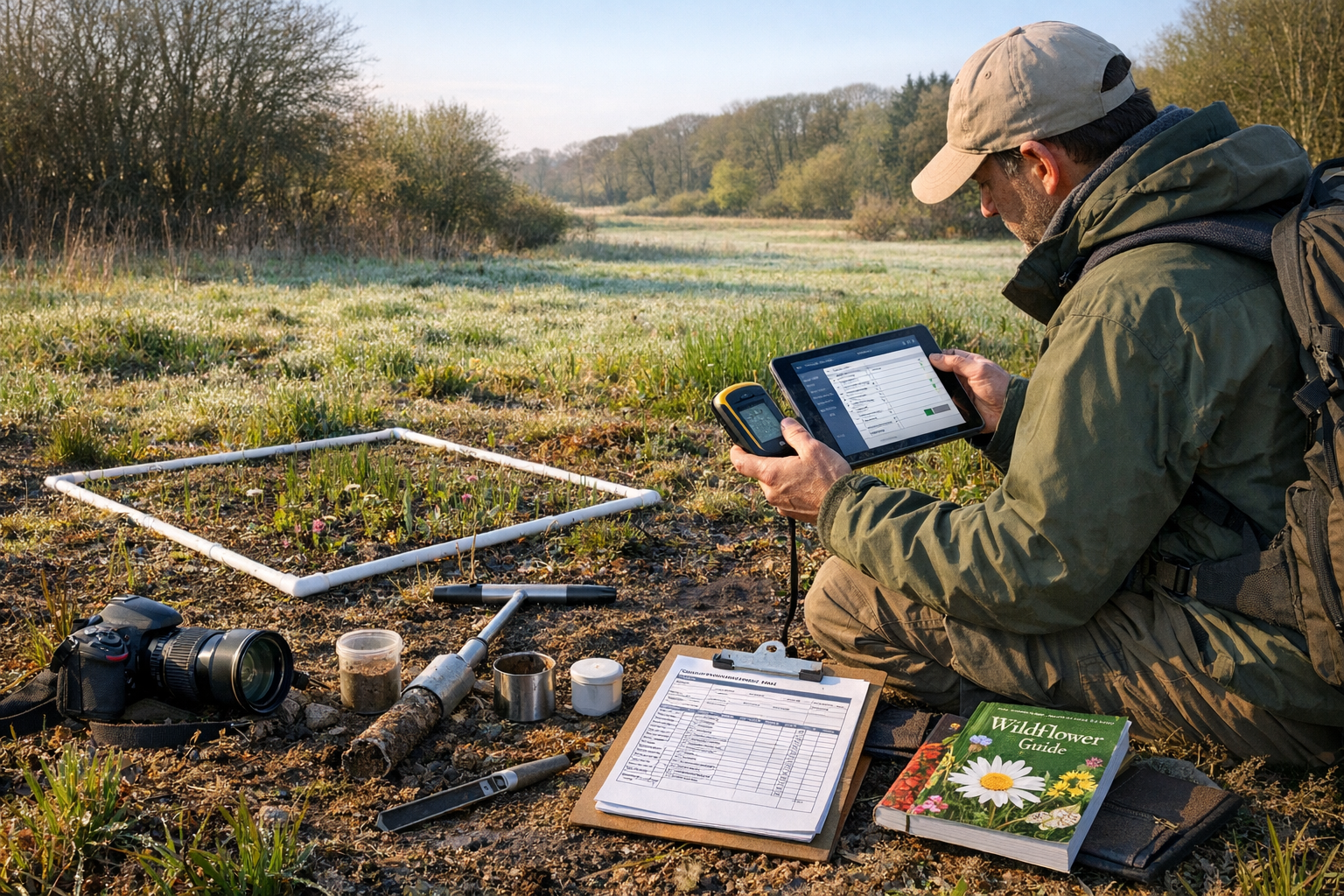
Technology and Software for Early Spring Surveys
Establishing comprehensive baselines in 2026 requires appropriate tools and expertise:
Geographic Information Systems (GIS):
- Software: QGIS (free, open-source) or ArcGIS (professional standard)
- Applications: Habitat mapping, area calculations, spatial analysis
- Data sources: Natural England Living England Habitat Maps, UK Centre for Ecology & Hydrology Land Cover Maps, OS MasterMap Topography
Field Data Collection:
- Mobile apps: iRecord, BTO BirdTrack, iNaturalist for species recording
- GPS units: Accurate location recording for repeat surveys
- Digital cameras: Photographic documentation of seasonal change
- Environmental sensors: Temperature, soil moisture, light levels
Database Management:
- Spreadsheet software: Excel or Google Sheets for basic data organization
- Database systems: Access or specialized ecological databases for complex datasets
- Cloud storage: Secure, accessible data backup and sharing
Expertise and Training Needs
Early Spring Baseline Establishment in 2026 Biodiversity Surveys demands specific competencies:
Botanical Expertise:
- Spring ephemeral plant identification
- Grassland community classification
- Habitat condition assessment methodology
- Understanding of seasonal variation in plant communities
Faunal Survey Skills:
- Breeding bird survey protocols
- Amphibian survey techniques
- Invertebrate sampling methods
- Understanding of species phenology
Habitat Assessment:
- Defra biodiversity metric methodology
- Habitat distinctiveness and condition scoring
- Strategic significance evaluation
- UKHab classification system
Data Analysis:
- Statistical methods for trend detection
- GIS spatial analysis
- Report writing and data presentation
- Quality assurance protocols
Organizations lacking in-house expertise should engage qualified ecological consultants who understand the importance of comprehensive seasonal coverage and can design monitoring programs that support long-term trend detection.
Real-World Applications: 2026 Survey Programs in Action
Marine Ecosystem Baseline Establishment
The Otway Marine Ecosystem Resilience (OMER) initiative provides a practical example of comprehensive baseline establishment. Following surveys in October-November 2025, the program planned expanded 2026 summer surveys (January-April in the Southern Hemisphere) including:
- Intertidal monitoring: Rocky shore communities, seasonal species composition
- Subtidal surveys: Kelp forest health, fish populations, invertebrate communities
- Multi-site expansion: Broadening geographic coverage for regional baseline
- Community involvement: Citizen science integration for sustained monitoring
This approach demonstrates key principles:
- 🔄 Continuity: Building on previous surveys rather than starting fresh
- 📍 Spatial coverage: Expanding to capture ecosystem variability
- 👥 Capacity building: Engaging communities for long-term sustainability
- 📊 Adaptive design: Refining methods based on initial findings
Terrestrial Sentinel Site Networks
Regional biodiversity baseline programs, such as those coordinated through organizations like Pepperwood Preserve in California, demonstrate long-term monitoring frameworks specifically designed for baseline establishment and change assessment:
Network Characteristics:
- Multiple sites representing regional habitat diversity
- Standardized protocols enabling cross-site comparison
- Long-term commitment to sustained monitoring
- Integration of climate, vegetation, and wildlife data
UK Applications:
Similar approaches support biodiversity net gain strategies by:
- Establishing regional reference conditions
- Documenting natural variation ranges
- Providing context for site-specific assessments
- Supporting strategic conservation planning
Development Project Baselines
For development projects requiring biodiversity assessments, early spring 2026 baseline establishment offers specific advantages:
Planning Timeline Benefits:
- Surveys completed before peak construction season
- Adequate time for biodiversity net gain planning
- Flexibility to adjust designs based on baseline findings
- Reduced risk of survey season delays
Regulatory Compliance:
- Alignment with Defra seasonal survey guidance
- Comprehensive data supporting planning applications
- Reduced likelihood of survey adequacy challenges
- Strong foundation for monitoring requirements
Financial Planning:
- Accurate habitat valuation for biodiversity unit calculations
- Early identification of on-site versus off-site delivery options
- Reduced risk of unexpected ecological constraints
- Better-informed budget allocation
Strategic Alignment with 2026-2029 Conservation Goals
International Framework Integration
The United Nations Environment Programme World Conservation Monitoring Centre (UNEP-WCMC) launched its 2026-2029 strategy focused on achieving Kunming-Montreal Global Biodiversity Framework ambitions. Early Spring Baseline Establishment in 2026 Biodiversity Surveys aligns with these global objectives by:
Target 1: Spatial Planning
- Comprehensive baseline data supports landscape-scale conservation planning
- Identifies priority areas for protection and restoration
- Provides evidence for strategic conservation decisions
Target 2: Restoration
- Establishes pre-restoration conditions for effectiveness monitoring
- Documents ecosystem recovery trajectories
- Supports adaptive management approaches
Target 3: Protected Areas
- Provides baseline data for protected area designation
- Monitors condition of existing protected sites
- Supports management effectiveness evaluation
Target 10: Sustainable Management
- Documents current management impacts
- Supports evidence-based management decisions
- Enables demonstration of sustainable practices
UK Policy Context
Within the UK regulatory environment, comprehensive 2026 baselines support:
Biodiversity Net Gain Requirements:
- Robust pre-development condition assessments
- Accurate habitat distinctiveness and condition scoring
- Defensible baseline data for metric calculations
- Long-term monitoring frameworks for post-development assessment
Environmental Improvement Plans:
- Evidence of current biodiversity status
- Baseline against which improvements can be measured
- Support for local nature recovery strategies
- Contribution to national biodiversity indicators
Climate Change Adaptation:
- Documentation of climate-sensitive species and habitats
- Baseline for assessing climate change impacts
- Evidence supporting nature-based solutions
- Integration of biodiversity and climate objectives
Actionable Steps for Organizations Starting 2026 Surveys
Immediate Actions (January-February 2026)
1. Define Monitoring Objectives 🎯
- Clarify whether the goal is baseline establishment, intervention evaluation, or regulatory compliance
- Identify key questions the monitoring program should answer
- Determine required data outputs and reporting formats
2. Assemble Expertise and Resources 👥
- Engage qualified ecologists with appropriate taxonomic expertise
- Secure necessary equipment (GPS, cameras, field guides, sampling tools)
- Arrange access to GIS software and data sources
- Establish data management systems
3. Develop Survey Protocols 📋
- Design multi-visit schedule covering early spring through autumn
- Select appropriate survey methods for target habitats and species
- Establish quality assurance procedures
- Create data recording templates
4. Secure Site Access 🚪
- Obtain landowner permissions for multiple visits
- Identify access routes and parking locations
- Plan for seasonal access challenges (mud, flooding, vegetation growth)
- Arrange safety protocols for field teams
Early Spring Implementation (March-May 2026)
5. Conduct Initial Surveys 🔍
- Complete early spring habitat assessments while vegetation structure is visible
- Document early flowering species and amphibian breeding activity
- Establish photographic monitoring points for seasonal comparison
- Record baseline environmental conditions
6. Refine Methods Based on Findings 🔄
- Adjust survey effort based on habitat complexity
- Identify areas requiring specialist surveys
- Modify timing of subsequent visits based on phenological observations
- Document methodological decisions for consistency
7. Begin Data Analysis 📊
- Enter field data into databases promptly
- Conduct preliminary habitat classifications
- Identify knowledge gaps requiring additional surveys
- Prepare interim findings for internal review
Mid-Year Review (June-July 2026)
8. Assess Baseline Quality ✅
- Evaluate whether surveys have captured adequate habitat and species diversity
- Identify any seasonal gaps requiring additional visits
- Review data quality and completeness
- Compare findings against survey objectives
9. Plan Autumn Surveys 🍂
- Schedule late-season visits to capture seasonal decline patterns
- Identify species or habitats requiring autumn assessment
- Plan for seed collection or propagule surveys if relevant
- Arrange final photographic documentation
10. Develop Preliminary Baseline Report 📄
- Compile findings from spring and early summer surveys
- Produce habitat maps and species inventories
- Document baseline conditions and natural variability
- Identify preliminary trends or patterns
Long-Term Framework (Late 2026 and Beyond)
11. Establish Ongoing Monitoring Schedule 📅
- Design multi-year monitoring program (2027-2029 minimum)
- Determine frequency of repeat surveys for different habitat types
- Plan for adaptive management based on findings
- Secure long-term funding and resource commitments
12. Integrate with Management and Planning 🗺️
- Use baseline data to inform conservation strategies
- Support biodiversity net gain delivery planning
- Align monitoring with organizational objectives
- Communicate findings to stakeholders
Conclusion
Early Spring Baseline Establishment in 2026 Biodiversity Surveys: Capturing Full-Season Ecological Rhythms for Accurate Trend Detection represents far more than a technical refinement of survey methodology—it fundamentally transforms how organizations understand and protect ecological systems. By capturing the complete seasonal arc from initial emergence through peak activity and seasonal decline, early spring monitoring provides the comprehensive baseline data essential for distinguishing genuine ecological trends from temporary fluctuations.
The evidence is compelling: habitat distinctiveness values can double between winter and spring assessments, representing substantial differences in biodiversity unit calculations and conservation value. Without early spring data, critical ecological components—early flowering plants, amphibian breeding populations, spring ephemeral species, and early-season pollinators—remain invisible, creating systematically undervalued baselines that compromise all future assessments.
As 2026 progresses, organizations face a strategic choice. Those beginning comprehensive monitoring in early spring will establish robust baselines supporting accurate trend detection, effective conservation interventions, and defensible regulatory compliance. Those delaying surveys until peak summer will capture only isolated snapshots, missing the ecological complexity that determines true habitat quality and long-term viability.
Next Steps for Your Organization
Start now by defining clear monitoring objectives and assembling the expertise needed for comprehensive seasonal coverage. Engage qualified ecological consultants who understand the importance of early spring surveys and can design monitoring programs aligned with your specific needs—whether baseline establishment, intervention evaluation, or regulatory compliance.
Plan strategically for multi-season data collection spanning early spring through autumn 2026, with commitment to continued monitoring in 2027-2029. This multi-year framework enables statistical distinction between weather-driven variation and genuine ecological trends, providing confidence in management decisions and conservation outcomes.
Invest in quality baseline establishment now to avoid the costs of flawed data later. The difference between a robust early spring baseline and a compromised peak-season snapshot determines the success of biodiversity net gain delivery, conservation effectiveness, and regulatory compliance for years to come.
The 2026 early spring survey window is opening. Organizations that capture it will possess the comprehensive ecological understanding needed to navigate an increasingly complex conservation landscape. Those that miss it will spend years working from incomplete baselines, never fully understanding the ecosystems they seek to protect.
The choice—and the opportunity—is immediate. 🌱
