
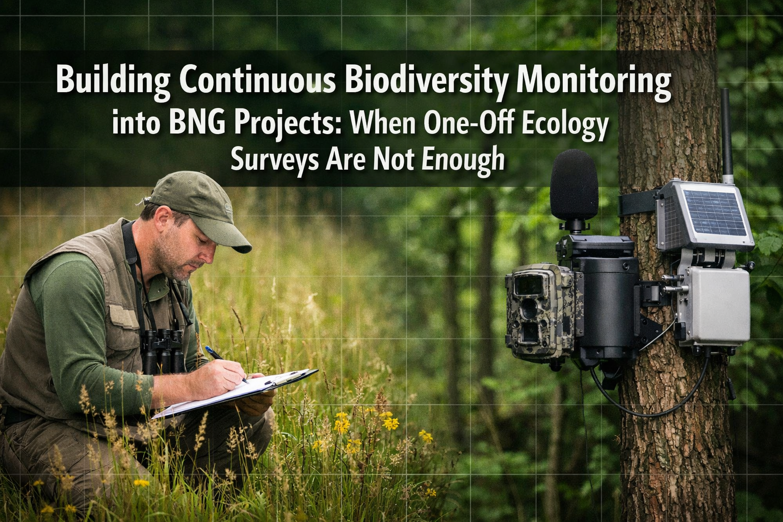
The ecologist stands at the edge of a newly created wetland, clipboard in hand, counting waterfowl on a crisp October morning. She ticks boxes, records species, and photographs the site. By afternoon, the survey is complete—a snapshot frozen in time. But what happens next spring when the habitat floods differently? What about the breeding season three years from now? Or the subtle shifts in plant communities over the next decade? In 2026, the era of one-off ecology surveys for Biodiversity Net Gain (BNG) projects is rapidly giving way to a new paradigm: continuous, multi-year monitoring that captures the true complexity of ecological change.
Building Continuous Biodiversity Monitoring into BNG Projects: When One‑Off Ecology Surveys Are Not Enough represents a fundamental shift in how developers, ecologists, and land managers approach their legal obligations. With the mandatory 30-year monitoring requirement now firmly established in England's BNG framework [1], practitioners must transition from snapshot assessments to sophisticated, season-long observation systems that track non-linear biodiversity dynamics across decades.
Key Takeaways
🔍 30-year monitoring is now mandatory: Developers must implement Habitat Management and Monitoring Plans (HMMPs) that track biodiversity enhancement continuously for at least three decades, moving beyond single-point surveys [1].
📊 Four-pillar monitoring approach: Modern continuous monitoring combines traditional field surveys, remote sensing technology, environmental DNA (eDNA) analysis, and bioacoustic methods to capture comprehensive biodiversity data [2].
💰 Cost-effectiveness through technology: While upfront investment in monitoring infrastructure may be higher, automated systems and community-based approaches can reduce long-term costs compared to repeated manual surveys.
⚖️ Legal enforcement mechanisms exist: Local Planning Authorities have enforcement powers, and Conservation Covenants provide legal tools to ensure compliance when monitoring reveals non-delivery of BNG commitments [4].
🌱 Non-linear dynamics require adaptive management: Biodiversity recovery rarely follows predictable paths—continuous monitoring enables ecologists to detect unexpected trends and adjust management interventions accordingly.
Understanding the Limitations of One-Off Ecology Surveys in BNG
Traditional ecological surveys have served the planning system well for decades. A competent ecologist visits a site, conducts standardized assessments during optimal survey windows, and produces a baseline report. This approach works adequately for identifying protected species or assessing immediate development impacts. However, when applied to Biodiversity Net Gain projects, one-off surveys reveal critical shortcomings.
Why Snapshot Surveys Fall Short
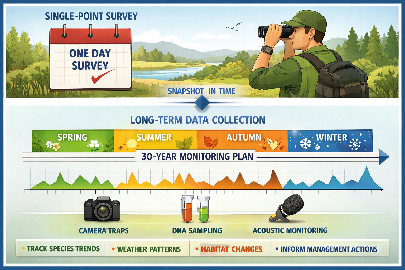
Temporal blindness represents the most significant limitation. A single-day survey in July might miss early-breeding birds, autumn-fruiting plants, or winter-roosting bats. Biodiversity operates on multiple overlapping temporal scales—daily, seasonal, annual, and decadal—that cannot be captured in a snapshot.
Weather-dependent variability further complicates matters. Amphibian breeding success, butterfly emergence, and flowering phenology all respond dramatically to temperature and rainfall patterns. A survey conducted during an unusually dry spring may dramatically underestimate the site's true biodiversity potential.
Establishment lag effects mean newly created or restored habitats often appear biodiversity-poor in their first years. A woodland planted in Year 1 may show minimal bird diversity in Year 2, moderate diversity by Year 5, and rich breeding communities by Year 10. One-off surveys cannot distinguish between failed habitat creation and ecosystems still in their establishment phase.
The 10% biodiversity net gain target applies uniformly across all projects [3], requiring developers to demonstrate sustained enhancement over the full 30-year period. This legal obligation makes continuous verification essential—a single survey at Year 1 cannot prove compliance at Year 15.
The Regulatory Shift Toward Continuous Monitoring
As of late 2025, regulatory expectations have evolved significantly. Habitat Management and Monitoring Plans (HMMPs) are now standard practice, with developers scheduling continuous monitoring throughout the entire 30-year obligation period [1]. This shift reflects lessons learned from 18 months of BNG implementation, during which stakeholders grappled with baseline assessments, conservation covenants, and habitat banks [5].
Local Planning Authorities (LPAs) now possess clear enforcement powers to set specific and proportionate monitoring requirements [4]. When developers fail to deliver agreed environmental enhancements, LPAs can pursue enforcement actions backed by monitoring evidence. This regulatory framework transforms monitoring from a voluntary best practice into a legal necessity.
For developers working on small development projects or planning biodiversity strategies, understanding these monitoring requirements early prevents costly retrofitting later.
Building Continuous Biodiversity Monitoring into BNG Projects: Methods and Technologies
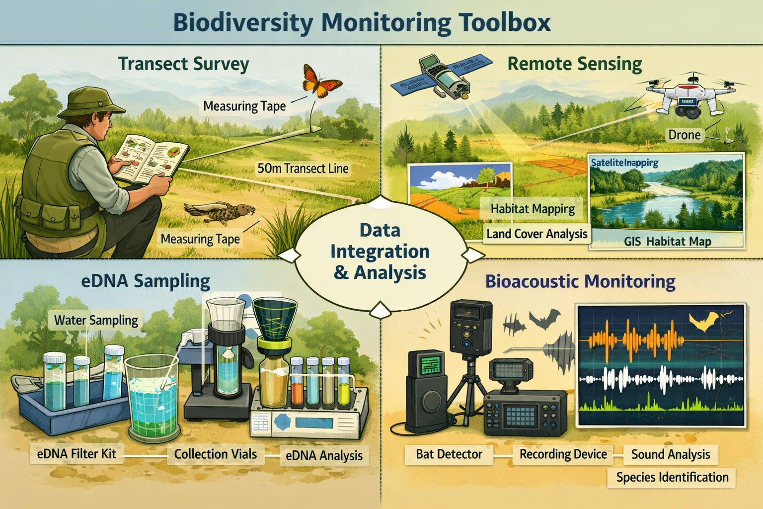
Transitioning from one-off surveys to continuous monitoring requires ecologists to expand their methodological toolkit significantly. Modern biodiversity monitoring employs four complementary pillars that together provide comprehensive, scalable observation systems [2].
Pillar 1: Enhanced Traditional Field Surveys
Traditional ecological field surveys remain foundational, but continuous monitoring requires strategic scheduling across multiple seasons and years. Rather than a single site visit, ecologists design survey schedules that capture key phenological windows:
- Spring breeding season surveys (March-June) for birds, amphibians, and early-flowering plants
- Summer peak diversity surveys (June-August) for invertebrates, reptiles, and full botanical assessments
- Autumn migration and fruiting surveys (September-November) for seed-dispersing species and migratory birds
- Winter roosting and structural surveys (December-February) for bats, wintering waterfowl, and habitat condition
Frequency considerations balance thoroughness against cost. Year 1, 3, 5, 10, 15, 20, and 30 represent a common monitoring schedule, with more intensive observation during the critical establishment phase (Years 1-5).
Standardized protocols ensure comparability across survey events. Using identical transect routes, quadrat locations, and survey methodologies allows ecologists to detect genuine ecological change rather than methodological artifacts.
Pillar 2: Remote Sensing and Drone Technology
Remote sensing offers cost-effective scalability for monitoring habitat structure and vegetation change across large sites. Technologies include:
Satellite imagery provides free or low-cost multispectral data capable of tracking vegetation health (NDVI indices), habitat extent, and land-cover change. While spatial resolution limits fine-scale species detection, satellite data excels at landscape-level monitoring.
Drone-based surveys deliver high-resolution imagery (sub-5cm pixels) suitable for mapping individual trees, monitoring scrub encroachment, and assessing habitat condition indicators. Thermal imaging attachments enable detection of warm-blooded animals, while LiDAR sensors capture detailed structural data on vegetation height and complexity.
Automated analysis using machine learning algorithms can classify habitat types, detect invasive species, and flag areas requiring management intervention—reducing the time ecologists spend on routine monitoring tasks.
Pillar 3: Environmental DNA (eDNA) Sampling
Environmental DNA represents a revolutionary approach to detecting species presence without direct observation [2]. Organisms continuously shed genetic material through skin cells, feces, mucus, and other biological traces. Water, soil, or air samples collected from a site contain this genetic information, which laboratory analysis can identify to species level.
eDNA advantages include:
- Detection of cryptic or rare species that evade traditional surveys
- Reduced field time (sample collection takes hours, not days)
- Minimal habitat disturbance
- Standardized, repeatable protocols
- Comprehensive species inventories including microorganisms
eDNA limitations require consideration:
- Cannot distinguish between living populations and transient individuals
- Requires specialized laboratory facilities and expertise
- Cost per sample remains higher than visual surveys (though decreasing)
- Genetic reference databases incomplete for some taxonomic groups
For BNG projects focused on aquatic habitats or monitoring great crested newts, eDNA offers particularly strong value.
Pillar 4: Bioacoustic Monitoring
Autonomous recording units (ARUs) capture continuous audio data from habitats, enabling detection of vocalizing species including birds, bats, amphibians, and some insects. Modern ARUs can operate for months on battery power, recording scheduled intervals (e.g., dawn chorus, dusk bat activity) or continuously.
Automated species identification software analyzes recordings using machine learning algorithms trained on species-specific call patterns. While not yet 100% accurate, these systems dramatically reduce the time required to process thousands of hours of audio data.
Bioacoustic benefits include:
- 24/7 monitoring capturing nocturnal and crepuscular species
- Permanent audio archives enabling retrospective analysis
- Detection of rare or unexpected species
- Minimal observer bias
- Cost-effective once equipment purchased
Combining bioacoustic monitoring with traditional surveys provides comprehensive coverage of both visual and acoustic biodiversity indicators.
Designing Season-Long and Multi-Year Monitoring Programs for BNG
Effective continuous monitoring requires careful program design that balances ecological rigor, practical feasibility, and cost constraints. Ecologists must make strategic decisions about survey intensity, technology deployment, and adaptive management triggers.
Establishing Baseline Monitoring Protocols
Before development commences, ecologists must establish robust baseline conditions using the same methodologies that will track future change. This baseline should:
Capture inter-annual variability through at least two years of pre-development surveys. Single-year baselines may coincidentally occur during population peaks or troughs, creating misleading reference conditions.
Document habitat condition using standardized metrics aligned with the biodiversity metric calculation. Habitat distinctiveness, condition scores, and strategic significance must all be quantified using field-verifiable indicators.
Identify reference ecosystems representing the target condition for created or enhanced habitats. Local nature reserves, ancient woodlands, or species-rich grasslands provide benchmarks against which BNG habitat development can be measured.
Structuring the 30-Year Monitoring Timeline
The mandatory 30-year monitoring period [1] requires strategic scheduling that concentrates effort when ecological change is most rapid and reduces intensity once habitats stabilize.
Intensive establishment phase (Years 1-5): Annual or biannual surveys track critical habitat development, identify establishment failures early, and verify that management interventions achieve intended outcomes. This phase typically requires the highest monitoring investment.
Consolidation phase (Years 6-15): Surveys every 2-3 years assess whether habitats are maturing toward target conditions and whether biodiversity is approaching reference ecosystem levels.
Maintenance phase (Years 16-30): Surveys every 5 years verify ongoing compliance and detect any long-term degradation or unexpected ecological shifts.
Trigger-based additional surveys: Extreme weather events, disease outbreaks, or management failures may necessitate unscheduled surveys to assess impacts and adjust management.
Interpreting Non-Linear Biodiversity Dynamics
Biodiversity recovery rarely follows smooth, predictable trajectories. Ecologists must recognize and interpret common non-linear patterns:
Initial diversity dips often occur immediately after habitat creation as pioneer species colonize before target species arrive. A newly created wetland may initially support only common generalist species, with specialist wetland birds arriving years later.
Threshold effects mean small management changes can trigger disproportionate biodiversity responses. Grazing pressure, water levels, or scrub cover may show minimal biodiversity impact until crossing critical thresholds, after which rapid change occurs.
Succession dynamics drive predictable habitat change over time. Newly planted woodland progresses through grassland, scrub, young woodland, and mature woodland phases, each supporting different species assemblages. Monitoring must distinguish between expected successional change and undesired habitat degradation.
Stochastic events including droughts, floods, or disease outbreaks can cause sudden biodiversity fluctuations unrelated to management quality. Continuous monitoring enables ecologists to contextualize these events rather than misinterpreting them as BNG failures.
Adaptive management responses use monitoring data to trigger management adjustments. If bird diversity falls below target thresholds, ecologists might recommend additional scrub clearance, nest box installation, or predator control—then monitor whether these interventions succeed.
Cost Considerations and Trade-Offs
Continuous monitoring requires upfront investment in equipment, training, and program design, but can reduce long-term costs compared to repeated consultant-led surveys.
Technology investment costs:
- Automated recording units: £200-£1,500 per unit
- Camera traps: £150-£600 per unit
- Drone equipment: £1,000-£15,000 depending on capabilities
- eDNA sampling kits: £50-£200 per sample plus laboratory fees
Personnel costs:
- Ecologist time for annual field surveys: £1,500-£5,000 per survey event
- Data analysis and reporting: £2,000-£8,000 per monitoring year
- Technology maintenance and data management: £1,000-£3,000 annually
Cost-reduction strategies include:
- Deploying automated technologies to reduce field visit frequency
- Training site managers to conduct routine monitoring tasks
- Engaging citizen science volunteers for supplementary surveys
- Sharing monitoring infrastructure across multiple BNG sites in the same region
For developers creating biodiversity plans, budgeting for continuous monitoring from project inception prevents financial surprises during the 30-year obligation period.
Community Engagement and Enforcement in Long-Term BNG Monitoring
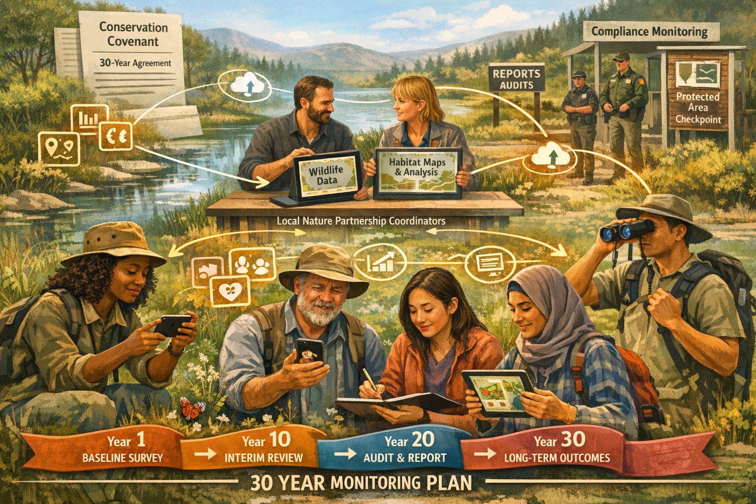
Continuous biodiversity monitoring over three decades cannot rely solely on professional ecologists conducting periodic surveys. Successful programs integrate community-based monitoring and robust enforcement mechanisms to ensure accountability and sustained engagement [3].
Integrating Citizen Science and Community Oversight
Local Nature Partnerships (LNPs), environmental charities, and community groups increasingly participate in BNG monitoring, providing both supplementary data and public accountability [3].
Citizen science contributions include:
- Regular wildlife sightings logged through apps like iNaturalist or eBird
- Organized BioBlitz events engaging local residents in species recording
- School groups conducting seasonal surveys as educational activities
- Volunteer monitors adopting specific BNG sites for regular observation
Training and quality assurance ensure citizen science data meets scientific standards. Professional ecologists provide identification training, standardized recording protocols, and data verification to maintain reliability.
Community benefits extend beyond monitoring data. Local engagement builds public support for biodiversity enhancement, creates educational opportunities, and fosters long-term stewardship of BNG sites. Residents who participate in monitoring become advocates for habitat protection.
Transparency mechanisms including public access to the Biodiversity Gain Site Register enable communities to track whether developers deliver promised enhancements [4]. This transparency creates reputational incentives for compliance beyond legal requirements.
Enforcement Powers and Conservation Covenants
When monitoring reveals non-compliance with BNG obligations, several enforcement mechanisms ensure corrective action [4].
Local Planning Authority enforcement: LPAs possess authority to pursue enforcement actions when developers fail to deliver agreed environmental enhancements. Monitoring reports provide the evidence base for these actions.
Conservation Covenants represent a legal tool enabling enforcement if monitoring reveals non-compliance during the 30-year period [4]. These covenants create binding obligations that run with the land, ensuring continuity even if ownership changes.
Financial securities may be required upfront to fund remedial action if monitoring shows BNG targets are not being met. This approach ensures funds are available for corrective management without protracted legal proceedings.
Adaptive management triggers should be specified in HMMPs, defining the monitoring thresholds that require management intervention. Clear trigger points (e.g., "if bird diversity falls below 80% of target by Year 5") enable proactive responses before serious failures occur.
Data Management and Reporting Systems
Thirty years of monitoring generates substantial data requiring systematic management to remain useful.
Centralized databases store monitoring records in standardized formats enabling trend analysis and comparison across survey years. Cloud-based systems ensure data security and accessibility to authorized stakeholders.
Regular reporting cycles (typically annual or biannual) summarize monitoring findings, compare results against targets, and recommend management adjustments. Reports should be accessible to LPAs, landowners, and community stakeholders.
Long-term data archiving ensures monitoring records remain available throughout the 30-year period and beyond. Digital records should include metadata documenting survey methodologies, observer identities, and weather conditions to enable future interpretation.
Integration with national systems including the Biodiversity Gain Site Register creates transparency and enables landscape-scale analysis of BNG effectiveness across England [4].
Practical Implementation: A Field-Level Blueprint
For ecologists tasked with designing continuous monitoring programs, the following step-by-step blueprint provides practical guidance:
Step 1: Define Clear, Measurable Objectives
Specify exactly what the monitoring program must demonstrate:
- Minimum 10% biodiversity net gain maintained throughout 30 years
- Specific target species or communities (e.g., "breeding populations of at least 5 farmland bird species")
- Habitat condition thresholds (e.g., "grassland sward height 10-20cm across 70% of area")
- Functional ecosystem indicators (e.g., "pollinator visitation rates comparable to reference meadows")
Step 2: Select Appropriate Monitoring Methods
Match monitoring techniques to objectives, site characteristics, and budget:
- Small sites (<2 hectares): Traditional field surveys supplemented by camera traps and acoustic recorders
- Medium sites (2-10 hectares): Combination of field surveys, drone mapping, and targeted eDNA for aquatic features
- Large sites (>10 hectares): Multi-pillar approach including satellite monitoring, automated technologies, and strategically located intensive survey plots
Step 3: Establish Baseline Conditions
Conduct thorough pre-development surveys across multiple seasons and at least two years. Document:
- Complete species inventories for key taxonomic groups
- Habitat condition assessments using standardized metrics
- Photographic records from fixed monitoring points
- Reference ecosystem comparisons
Step 4: Design the Monitoring Schedule
Create a detailed timeline specifying:
- Survey frequency for each monitoring method (e.g., "bioacoustic recording April-September annually Years 1-5")
- Responsible parties for each monitoring task
- Data submission and reporting deadlines
- Budget allocation across the 30-year period
Step 5: Implement Adaptive Management Protocols
Define decision rules linking monitoring results to management actions:
- Threshold triggers requiring intervention (e.g., "invasive species covering >10% of area")
- Management options for common scenarios (e.g., scrub encroachment, drainage issues)
- Escalation procedures if initial interventions fail
- Re-monitoring schedules to verify intervention effectiveness
Step 6: Ensure Long-Term Institutional Continuity
Establish mechanisms ensuring monitoring continues despite staff turnover, organizational changes, or ownership transfers:
- Legal agreements (Conservation Covenants, Section 106 obligations) binding successors
- Financial provisions (endowments, bonds, or staged payments) funding monitoring throughout 30 years
- Clear documentation enabling new personnel to continue monitoring consistently
- Backup data storage protecting against loss
Step 7: Engage Stakeholders and Build Transparency
Create communication channels keeping stakeholders informed:
- Annual monitoring reports submitted to LPAs and made publicly available
- Community engagement events sharing findings and celebrating successes
- Data sharing with Local Nature Partnerships and biological recording centers
- Registration of off-site gains on the Biodiversity Gain Site Register
For developers seeking to achieve 10% biodiversity net gain or deciding between on-site or off-site delivery, continuous monitoring must be factored into project planning from the outset.
Lessons from Early BNG Implementation
The first 18 months of mandatory BNG implementation (from February 2024 through mid-2025) provided valuable lessons for continuous monitoring programs [5].
Baseline assessment challenges: Many developers underestimated the time and expertise required for robust baseline surveys, leading to rushed assessments that created weak reference points for future monitoring.
Technology adoption barriers: While automated monitoring technologies offer significant advantages, many ecological consultancies lacked in-house expertise in eDNA analysis, bioacoustic interpretation, or drone operation—creating implementation delays.
Cost underestimation: Early projects frequently underbudgeted for 30-year monitoring obligations, focusing planning attention on upfront habitat creation costs while neglecting long-term monitoring expenses.
Habitat bank monitoring complexity: Off-site BNG delivery through habitat banks introduced monitoring coordination challenges, with multiple developers relying on single sites requiring integrated monitoring programs serving diverse stakeholders.
LPA capacity constraints: Some Local Planning Authorities struggled to review detailed HMMPs and monitoring reports due to limited ecological expertise, highlighting the need for standardized reporting formats and decision-support tools.
Positive outcomes included increased collaboration between developers and ecological consultancies, growing recognition of monitoring's importance in de-risking BNG delivery, and emergence of specialist monitoring service providers.
Future Developments and Policy Evolution
As BNG policy continues maturing in 2026 and beyond, several developments will shape continuous monitoring practice:
NSIP BNG commencement: Nationally Significant Infrastructure Projects will come under BNG requirements from May 2026 [4], bringing large-scale, complex developments into the monitoring framework and potentially driving innovation in landscape-scale monitoring approaches.
Standardized monitoring protocols: Government and professional bodies are expected to publish standardized monitoring methodologies ensuring consistency and comparability across BNG projects, reducing current variability in monitoring quality.
Technology cost reduction: As eDNA, bioacoustics, and drone technologies mature and achieve economies of scale, monitoring costs should decrease, making comprehensive programs more accessible to smaller developments.
Integration with nature recovery networks: BNG monitoring will increasingly align with broader nature recovery strategies, enabling landscape-scale assessment of biodiversity trends beyond individual development sites.
Enhanced enforcement: As the first wave of BNG projects reaches Year 3-5 monitoring milestones, enforcement actions against non-compliant developers will establish precedents clarifying LPA powers and developer obligations.
Conclusion
Building Continuous Biodiversity Monitoring into BNG Projects: When One‑Off Ecology Surveys Are Not Enough represents both a regulatory requirement and an ecological necessity. The mandatory 30-year monitoring period demands that ecologists, developers, and land managers fundamentally rethink their approach to biodiversity assessment—moving from convenient snapshots to rigorous, multi-year observation systems capable of capturing the true complexity of ecological change.
The transition from one-off surveys to continuous monitoring requires upfront investment in technology, training, and program design. However, this investment delivers substantial returns: robust evidence of BNG compliance, early detection of habitat establishment problems when corrective action remains feasible, reduced long-term costs through automation and community engagement, and ultimately, genuine biodiversity enhancement rather than paper compliance.
Actionable Next Steps
For ecologists and developers embarking on BNG projects in 2026:
✅ Budget realistically for 30-year monitoring from project inception, allocating 10-15% of total BNG costs to monitoring and adaptive management
✅ Invest in multi-pillar monitoring combining traditional surveys with automated technologies appropriate to site characteristics and target species
✅ Establish robust baselines through multi-season, multi-year pre-development surveys providing reliable reference conditions
✅ Design adaptive management protocols with clear decision rules linking monitoring results to management interventions
✅ Engage communities in monitoring to build transparency, reduce costs, and foster long-term stewardship
✅ Ensure institutional continuity through legal agreements, financial provisions, and comprehensive documentation
✅ Embrace non-linear dynamics by interpreting monitoring data in ecological context rather than expecting smooth, predictable biodiversity trajectories
The era of one-off ecology surveys has passed. Continuous biodiversity monitoring is not merely a compliance burden—it represents an opportunity to demonstrate genuine environmental leadership, de-risk BNG delivery, and contribute to England's nature recovery. By implementing the field-level blueprint outlined above, ecologists can transition confidently from snapshot assessments to sophisticated, season-long and multi-year monitoring systems that capture the full richness of biodiversity change across decades.
For expert guidance on implementing continuous monitoring in your BNG projects, contact our team of experienced biodiversity professionals.
References
[1] Biodiversity Net Gain Plan – https://arbtech.co.uk/biodiversity-net-gain-plan/
[2] The Biodiversity Monitoring Toolbox How To Choose The Right Approach For Your Project – https://gentian.io/blog/the-biodiversity-monitoring-toolbox-how-to-choose-the-right-approach-for-your-project
[3] Engaging People For Biodiversity Net Gain – https://www.ids.ac.uk/opinions/engaging-people-for-biodiversity-net-gain/
[4] Biodiversity Net Gain Consultation Latest News – https://www.nfuonline.com/news/biodiversity-net-gain-consultation-latest-news/
[5] Watch – https://www.youtube.com/watch?v=vObtCKLPNXE
[6] Biodiversity Net Gain Frequently Asked Questions – https://www.local.gov.uk/pas/about/pas-archive/biodiversity-net-gain-frequently-asked-questions
