
Over 90% of England's ancient grasslands have been lost since the 1930s, yet the tools available to measure what remains have never been more powerful or more accessible. The arrival of mandatory Biodiversity Net Gain (BNG) legislation has created an urgent, large-scale demand for habitat baseline data — and citizen science apps for biodiversity surveys are stepping in to meet it. In 2026, with BNG now extending to Nationally Significant Infrastructure Projects (NSIPs) from November onwards [7], the pressure on ecologists and developers to gather robust, compliant baseline assessments has intensified dramatically. This article examines how scalable apps and crowdsourced protocols are transforming that process, and what validation methods ensure the data holds up to regulatory scrutiny.
Key Takeaways
- Mandatory BNG now applies to NSIPs from November 2026, significantly expanding the volume of baseline biodiversity assessments required across England [7].
- Citizen science apps such as the UKHab platform by Coreo, Gentian True Sight, and EcoField Tracker are enabling faster, more scalable habitat surveys that feed directly into BNG metric calculations.
- Structured data validation protocols — including expert review layers, AI-assisted identification, and cross-referencing with national databases — are essential to ensure crowdsourced data meets regulatory standards.
- Real-world implementations, including Oxford City Council's BNG programme achieving 32.16% net gain for area habitats, demonstrate what well-managed data collection can deliver [8].
- Combining trained volunteers with professional ecologists produces the most cost-effective and legally defensible baseline assessments for BNG compliance.
Why 2026 Is a Turning Point for BNG Baseline Data Collection
The regulatory landscape shifted decisively in April 2026 when the Department for Environment, Food and Rural Affairs (Defra) confirmed that mandatory BNG requirements would apply to all NSIP types from 2 November 2026 [9]. This followed the earlier rollout of mandatory BNG for standard planning applications under the Town and Country Planning Act 1990, which had already created significant demand for high-quality baseline surveys.
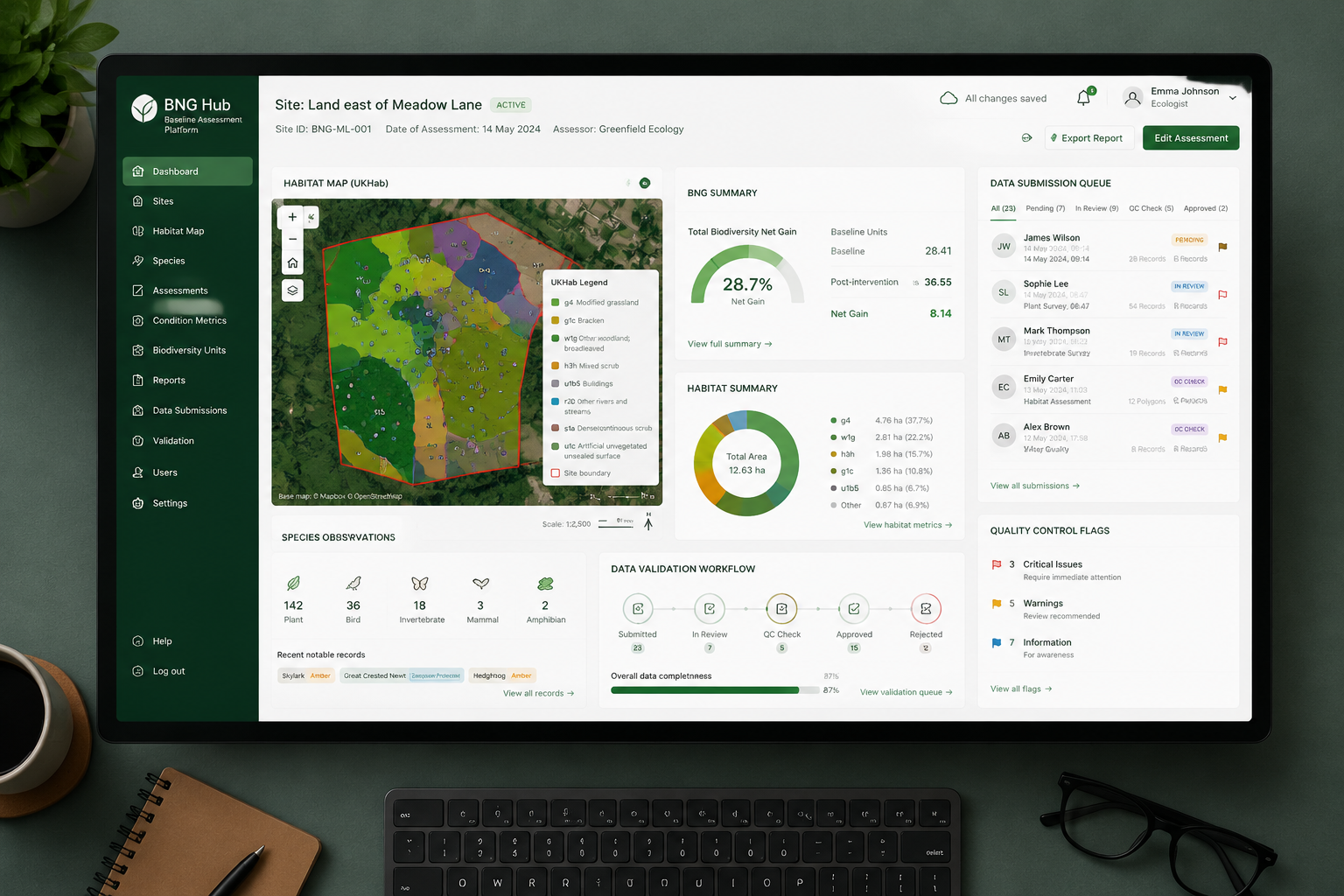
Understanding what is in a biodiversity net gain assessment helps clarify why baseline data is so critical. The BNG metric requires a precise pre-development habitat map, scored using the UKHab classification system, before any uplift calculations can begin. Without accurate baseline data, neither the 10% net gain requirement nor any off-site compensation can be correctly calculated.
The scale of new projects requiring this data is substantial. NSIPs include roads, railways, energy infrastructure, and ports — large footprints that often cross multiple habitat types. Surveying these areas with professional ecologists alone would be prohibitively slow and expensive. Citizen science apps for biodiversity surveys offer a practical route to gathering this data at scale, provided the right protocols and validation systems are in place.
The Regulatory Stakes
Oxford City Council's experience illustrates what good data management can achieve. Between April 2024 and January 2026, the council approved two biodiversity gain plans that collectively delivered an overall biodiversity net gain of 32.16% for area habitats and 10.42% for watercourses [8]. These results depended on consistent, well-documented baseline assessments — exactly the kind of data that structured citizen science programmes can support.
For developers navigating this landscape, understanding the cost of biodiversity units and statutory credits is equally important. Inaccurate baseline data can lead to underestimating the number of biodiversity units required, creating costly compliance gaps later in the project.
Leading Citizen Science Apps for Biodiversity Surveys: Empowering Ecologists and Volunteers in 2026 BNG Baseline Assessments
A growing ecosystem of mobile and cloud-based tools now supports structured biodiversity data collection. Each platform has distinct strengths depending on the survey context, habitat type, and level of user expertise.
UKHab and BNG Platform by Coreo
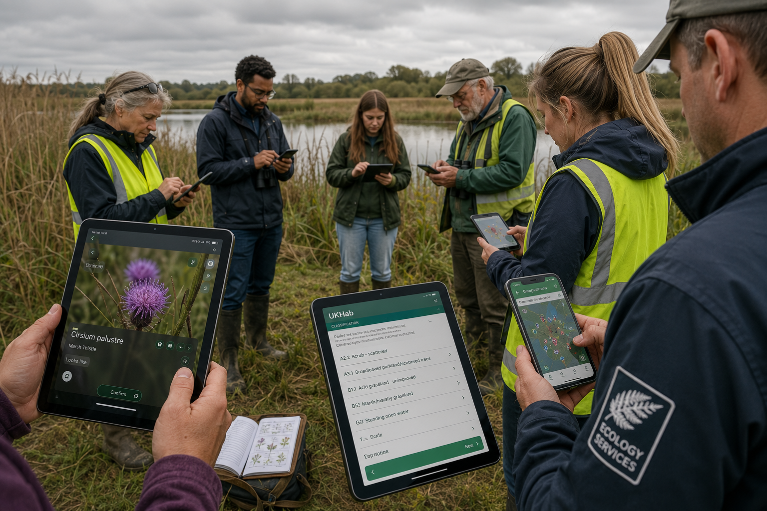
The UKHab platform developed by Coreo is one of the most directly BNG-relevant tools available in 2026. It streamlines habitat surveying by allowing surveyors to record habitats and species in the field using a mobile interface, then automatically export data to the statutory BNG metric format [4]. Organisations using the platform have reported survey efficiency gains of approximately 65% compared to traditional paper-based methods [4]. The automatic export function is particularly valuable because it eliminates transcription errors that could compromise regulatory submissions.
Gentian True Sight and True Sage
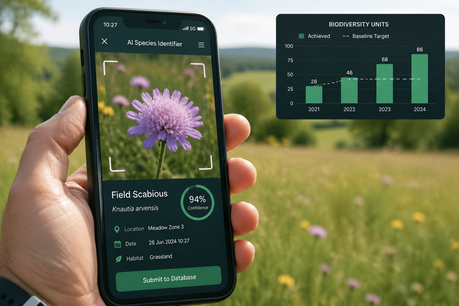
Gentian's two flagship products address different stages of the assessment process. True Sight is an AI-powered tool that delivers rapid habitat classifications compatible with the BNG metric, providing remote assessments within minutes and scaling easily across multiple sites [1]. This makes it particularly useful for initial site scoping, where a quick habitat overview can inform whether a full ground survey is needed.
True Sage is a cloud-based platform designed for more detailed work, enabling organisations to map habitats, track ecological changes over time, and meet compliance needs with precise biodiversity baselines [2]. Together, these tools can support both the rapid screening phase and the detailed assessment phase of a BNG project.
EcoField Tracker
Developed under the NetworkNaturePLUS initiative with support from the IUCN, EcoField Tracker is an open-source mobile app focused on freshwater and river barrier mapping [3]. It allows both citizens and scientists to collect structured environmental data in a standardised format, making it particularly useful for NSIP projects that cross river catchments or affect wetland habitats. Its open-source nature means it can be adapted and integrated into bespoke survey programmes.
UMAPIT
Developed by the University of Manchester, UMAPIT is an urban biodiversity recording app that enables users to learn about urban species and record wildlife sightings [5]. For BNG baseline assessments in urban development contexts — such as brownfield regeneration projects — UMAPIT provides a structured way to engage local volunteers who have knowledge of their immediate environment.
ObsIdentify and Arter
Looking at international models that are influencing UK practice, ObsIdentify from the Naturalis Biodiversity Center uses AI-powered photo recognition to identify plants, insects, and birds in real time, feeding directly into national observation databases [6]. Arter, developed by the Natural History Museum of Denmark, supports offline use and integrates with national databases, making it a model for how citizen science data can be systematically aggregated [6]. Both platforms demonstrate the technical maturity now achievable in this space.
| App / Platform | Primary Use | BNG Metric Integration | AI-Assisted ID | Offline Capable |
|---|---|---|---|---|
| UKHab by Coreo | Habitat surveying and BNG export | Direct export | No | Yes |
| Gentian True Sight | Rapid remote habitat classification | Yes | Yes | No |
| Gentian True Sage | Detailed habitat mapping and tracking | Yes | Yes | No |
| EcoField Tracker | Freshwater and river barrier mapping | Partial | No | Yes |
| UMAPIT | Urban species recording | No | No | Yes |
| ObsIdentify | Species photo identification | Database linked | Yes | Partial |
| Arter | Multi-species recording and citizen science | Database linked | No | Yes |
Protocols for Scalable Crowdsourced Data Collection
Deploying citizen science apps effectively requires more than simply downloading software. A structured protocol is essential to ensure that volunteer-collected data is consistent, traceable, and defensible under BNG regulations.
Tiered Surveyor Models
The most effective programmes use a tiered approach:
- Tier 1 — Trained volunteers: Complete standardised recording tasks such as photographing habitat types, logging GPS coordinates, and noting dominant plant species using guided app interfaces.
- Tier 2 — Experienced citizen scientists: Carry out more detailed species lists, condition assessments, and habitat boundary mapping with intermediate training.
- Tier 3 — Professional ecologists: Review, validate, and sign off on all submitted data before it enters the BNG metric calculation.
This model allows a single professional ecologist to supervise and validate the work of multiple volunteers, dramatically increasing the geographic coverage achievable within a given budget. Research into authoring platforms for mobile citizen science apps has shown that client-side machine learning guidance — where the app itself prompts users to improve photo quality or flag uncertain identifications — significantly enhances the quality of data gathered by non-expert participants [10].
Standardised Survey Protocols
All volunteers should follow a written survey protocol that specifies:
- The UKHab habitat classification categories to be used
- Minimum photo requirements per habitat patch (including scale reference)
- GPS accuracy thresholds (typically within 5 metres)
- Data entry fields that are mandatory versus optional
- Seasonal survey windows appropriate to the target habitats
Standardisation is non-negotiable for BNG compliance. The biodiversity net gain assessment process requires that baseline data can withstand scrutiny from local planning authorities, and inconsistent volunteer data is one of the most common points of failure.
Validation Methods for Regulatory Compliance
Data validation operates at multiple levels:
Automated validation within the app itself can flag entries that fall outside expected parameters — for example, a habitat type recorded in an area where satellite imagery suggests a different land cover, or a species record that falls outside its known range.
Expert review queues allow professional ecologists to review flagged records and either confirm, correct, or reject them before data is locked for metric calculation.
Cross-referencing with national databases such as the National Biodiversity Network (NBN) Atlas provides an additional check on species records, particularly for protected or notable species that carry greater weight in BNG calculations.
Audit trails built into platforms like Coreo's UKHab system record who submitted each data point, when, and from what device — creating the documentary evidence needed to satisfy planning conditions.
For developers who want to understand how this fits into the broader planning process, the guide on how to conduct a biodiversity impact assessment provides essential context on where baseline surveys sit within the overall assessment workflow.
Citizen Science Apps for Biodiversity Surveys: Empowering Ecologists and Volunteers in 2026 BNG Baseline Assessments — Real-World Applications
Large Infrastructure Projects
With mandatory BNG for NSIPs taking effect in November 2026 [7], large infrastructure projects face some of the most complex baseline assessment challenges. A major road or rail corridor may cross dozens of distinct habitat parcels over tens of kilometres. Deploying trained volunteer teams with standardised apps across multiple survey zones simultaneously — with professional ecologists reviewing data remotely via cloud platforms — is the only practical way to complete these assessments within planning timelines.
The Gentian True Sight platform's ability to deliver remote habitat classifications within minutes [1] is particularly relevant here, enabling rapid pre-screening of large areas before ground-truthing teams are deployed. This reduces the total number of site visits required while maintaining data quality.
Urban Regeneration and Small Development Projects
At the smaller end of the scale, citizen science approaches are equally valuable. Urban development projects, including those covered under BNG for small development projects, often involve brownfield sites where local ecological knowledge is limited. Apps like UMAPIT, designed specifically for urban species recording [5], can engage local residents and community groups in pre-development surveys, generating baseline data while also building public awareness of the biodiversity value of urban sites.
Off-Site Habitat Creation and Monitoring
Citizen science apps are not only useful for pre-development baselines. They are increasingly being used to monitor off-site habitat creation sites over the 30-year management period required under BNG. Volunteers can conduct regular condition assessments using standardised app protocols, with professional ecologists reviewing data annually. This approach makes long-term monitoring economically viable for habitat bank operators.
For landowners considering entering the BNG market, understanding how to sell biodiversity units and the monitoring obligations attached to habitat management agreements is essential before committing to a programme.
Key Considerations for Developers
Developers integrating citizen science data into their BNG submissions should be aware of the following:
- Legal defensibility: All volunteer data must be validated by a qualified ecologist before submission. Planning authorities are increasingly scrutinising baseline data quality.
- Seasonal constraints: Many habitat types require surveys during specific seasons. App-based programmes must be planned well in advance to capture data within the correct survey windows.
- Data ownership: Clarify data ownership and sharing arrangements with any platform provider before beginning a survey programme, particularly if data will be submitted to public databases.
- Integration with the BNG metric: Not all apps export data in a format directly compatible with the statutory metric. Platforms like Coreo's UKHab system [4] that offer direct export are preferable for streamlining compliance.
For a broader understanding of the planning obligations involved, the resource on achieving biodiversity net gain without the risk outlines the key pitfalls developers should avoid when relying on third-party data sources.
"The combination of structured volunteer programmes and AI-assisted validation is not a shortcut — it is a scalable system that, when properly managed, produces baseline data that is faster, cheaper, and no less rigorous than traditional survey methods alone."
Conclusion
Citizen science apps for biodiversity surveys are no longer a peripheral tool for enthusiasts — they are a practical, scalable infrastructure for meeting the growing demands of BNG baseline assessments in 2026 and beyond. The expansion of mandatory BNG to NSIPs from November 2026 [7][9] means the volume of required baseline surveys will increase substantially, and professional ecologists alone cannot meet that demand within realistic timelines or budgets.
The path forward is clear. Developers, ecologists, and planning teams should:
- Select platforms with direct BNG metric integration, such as the UKHab by Coreo system [4], to eliminate transcription errors and streamline regulatory submissions.
- Implement tiered surveyor models that pair trained volunteers with professional oversight, using AI-assisted tools like Gentian True Sight [1] for rapid remote pre-screening.
- Build validation protocols into every survey programme from the outset, including automated flags, expert review queues, and cross-referencing with national databases.
- Plan for seasonal survey windows well in advance, particularly for NSIP-scale projects where multiple habitat types require surveys at different times of year.
- Engage with professional ecological consultants to ensure all citizen science data is signed off by a qualified ecologist before submission to planning authorities.
For developers at the start of this process, the biodiversity net gain explained resource provides a strong foundation, while the guidance for developers section offers practical next steps tailored to project type and scale. The technology is ready — the question is whether project teams will deploy it with the rigour that regulatory compliance demands.
References
[1] True Sight – https://gentian.io/true-sight?utm_source=openai
[2] True Sage – https://gentian.io/true-sage?utm_source=openai
[3] Ecofield Tracker – https://blueriversfoundation.org/ecofield-tracker/?utm_source=openai
[4] Ukhab – https://coreo.io/ukhab/?utm_source=openai
[5] citizenscience.eu – https://www.citizenscience.eu/project/100?utm_source=openai
[6] Top 11 Mobile Apps Field Research Denmark Netherlands 2026 – https://www.jelsciences.com/top-11-mobile-apps-field-research-denmark-netherlands-2026.php?utm_source=openai
[7] Government Confirms Biodiversity Net Gain For Major Infrastructure From November 2026 – https://cieem.net/government-confirms-biodiversity-net-gain-for-major-infrastructure-from-november-2026/?utm_source=openai
[8] Biodiversity Report – https://www.oxford.gov.uk/biodiversity/biodiversity-report/6?utm_source=openai
[9] Biodiversity Net Gain Three Key Policy Updates – https://gowlingwlg.com/en-ca/insights-resources/articles/2026/biodiversity-net-gain-three-key-policy-updates?utm_source=openai
[10] arxiv – https://arxiv.org/abs/2212.05411?utm_source=openai
