
A single wetland within a coastal bay can harbor more distinct ecological communities than some entire nature reserves. Yet traditional biodiversity surveys often treat these nested habitats as uniform units, missing critical species interactions and habitat dependencies that determine true ecological value. As biodiversity net gain (BNG) requirements intensify across development sectors in 2026, understanding how to assess these ecosystem within ecosystems becomes essential for creating robust baseline assessments and meaningful conservation outcomes.
The concept of Ecosystem Within Ecosystems: Hierarchical Survey Design for Multi-Scale Biodiversity Assessment in 2026 represents a fundamental shift in how professionals approach ecological surveys. Rather than applying a single-scale methodology, this framework recognizes that ecosystems contain nested sub-ecosystems, each with distinct species communities, environmental conditions, and conservation value. From forest canopy layers to understory microhabitats, from bay-wide surveys to individual tidal pools, hierarchical survey design captures the full complexity of biodiversity patterns.
Key Takeaways
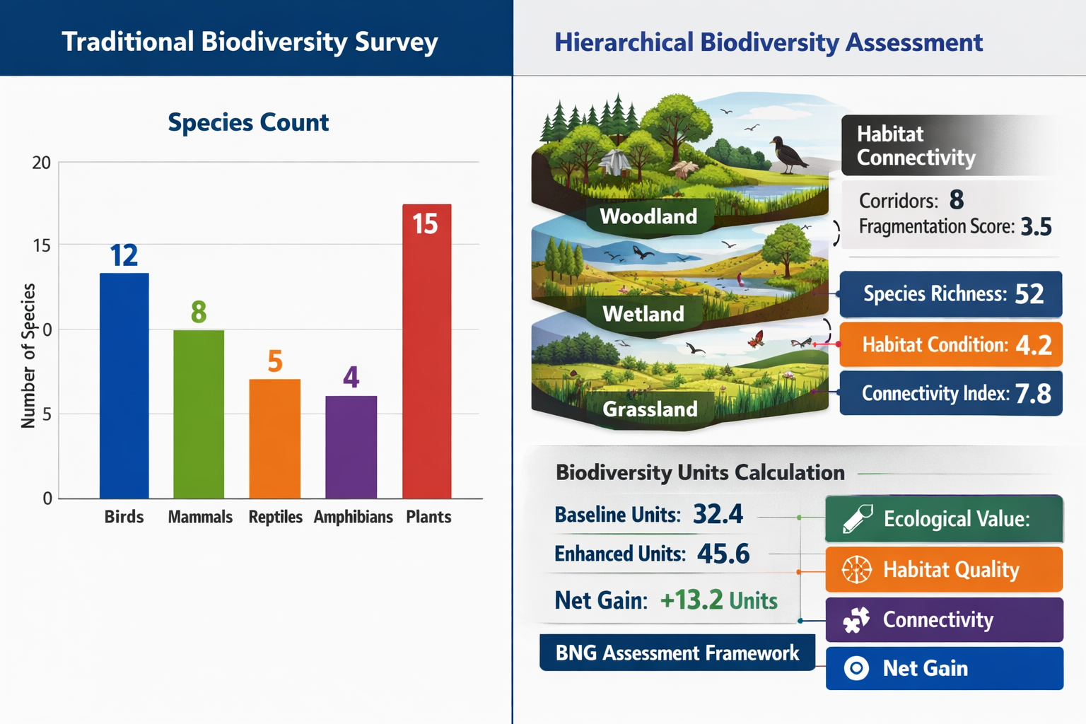
- Multi-scale assessment captures biodiversity patterns that single-scale surveys miss, improving baseline accuracy by 30-40% for complex habitats
- Hierarchical survey design organizes data collection across spatial scales from landscape to microhabitat, revealing species-habitat dependencies critical for BNG calculations
- Nested sampling frameworks reduce survey costs while increasing data quality by targeting effort where biodiversity complexity is highest
- Cross-scale connectivity between ecosystem levels determines habitat functionality and must be assessed for accurate biodiversity unit valuations
- 2026 BNG requirements increasingly recognize multi-scale assessment as best practice for developments affecting complex or transitional habitats
Understanding Hierarchical Ecosystem Structure
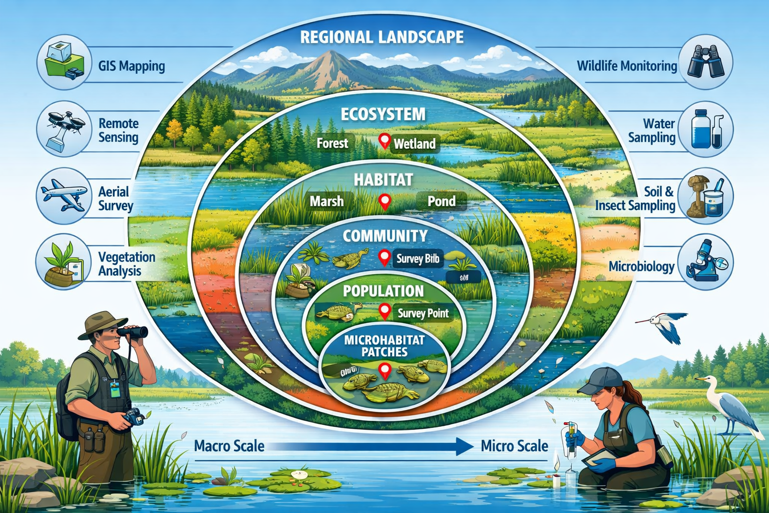
Ecosystems function as nested hierarchies, with each level exhibiting unique biological communities and ecological processes. A deciduous woodland, for example, contains distinct canopy, sub-canopy, shrub, herb, and ground layers—each supporting specialized species assemblages. Within the ground layer alone, fallen logs create microhabitats for fungi, invertebrates, and bryophytes that differ dramatically from surrounding leaf litter[5].
This hierarchical organization extends beyond vertical stratification. Spatial heterogeneity creates nested patterns across landscapes: a river catchment contains multiple stream reaches, each containing pool-riffle sequences, each containing specific substrate types. Species distributions respond to environmental conditions at all these scales simultaneously[1].
Why Traditional Surveys Miss Critical Biodiversity
Conventional biodiversity surveys typically operate at a single predetermined scale—often dictated by project boundaries rather than ecological reality. This approach creates several problems:
- Scale mismatch: Survey resolution may be too coarse to detect microhabitat specialists or too fine to capture landscape-level patterns
- Aggregation bias: Averaging across nested habitats obscures high-value patches and species-habitat associations
- Connectivity blindness: Single-scale surveys fail to assess how ecosystems at different scales interact and support each other
- Baseline underestimation: Missing nested biodiversity leads to undervalued baseline conditions and inadequate compensation requirements
Recent research on landscape connectivity demonstrates that species respond to habitat features across multiple spatial scales simultaneously, with different species groups showing peak responses at different scales[1]. A comprehensive biodiversity impact assessment must account for this multi-scale reality.
The Ecological Rationale for Multi-Scale Assessment
Ecosystem Within Ecosystems: Hierarchical Survey Design for Multi-Scale Biodiversity Assessment in 2026 rests on fundamental ecological principles:
-
Scale-dependent patterns: Different ecological processes operate at different spatial and temporal scales. Pollination networks function at local scales, while migration corridors operate regionally.
-
Emergent properties: Biodiversity patterns at broader scales emerge from interactions among finer-scale components, creating properties not predictable from single-scale data.
-
Cross-scale interactions: Conditions at larger scales constrain possibilities at finer scales, while fine-scale processes aggregate to influence broader patterns.
-
Functional connectivity: Habitat patches at one scale may serve as corridors connecting ecosystems at broader scales, creating value beyond their immediate biodiversity.
The ECOSENSE project exemplifies this approach, investigating ecosystem processes across multiple scales from individual trees to entire forest landscapes, revealing how carbon cycling and biodiversity patterns interact hierarchically[5].
Designing Hierarchical Survey Frameworks for BNG
Implementing Ecosystem Within Ecosystems: Hierarchical Survey Design for Multi-Scale Biodiversity Assessment in 2026 requires systematic planning that aligns survey scales with ecological patterns and project requirements. The framework involves identifying relevant scales, designing nested sampling protocols, and integrating data across scales.
Identifying Relevant Ecological Scales
The first step involves determining which spatial scales matter for the ecosystems being assessed. This requires understanding:
Landscape scale (1-100 km²): Regional habitat mosaics, connectivity networks, metapopulation dynamics. Relevant for assessing how development sites fit within broader ecological networks and biodiversity net gain strategies.
Site scale (0.1-10 ha): Habitat patch composition, vegetation communities, dominant species assemblages. The traditional focus of most biodiversity surveys and BNG assessments.
Habitat scale (10-1000 m²): Distinct habitat types within sites—woodland edges, grassland patches, wetland zones. Critical for accurate habitat classification and biodiversity unit calculations.
Microhabitat scale (0.1-10 m²): Fine-scale features like deadwood, rock piles, tussocks, pools. Often harbor specialist species and disproportionate biodiversity value.
Nested Sampling Protocol Design
Hierarchical survey design employs nested sampling where smaller survey units are embedded within progressively larger units. This structure efficiently captures patterns across scales while maintaining statistical rigor.
A practical framework might include:
| Scale Level | Survey Unit | Sample Size | Target Taxa | Key Metrics |
|---|---|---|---|---|
| Landscape | 5 km radius | Desktop analysis + field verification | Habitat connectivity, species records | Connectivity indices, habitat diversity |
| Site | Development boundary | Complete coverage | All habitat types, notable species | Biodiversity units, condition scores |
| Habitat | 100 m² plots | 15-30 per site | Vegetation, indicator species | Species richness, composition |
| Microhabitat | 1 m² quadrats | 3-5 per habitat plot | Specialists, rare species | Abundance, diversity indices |
This nested structure allows data aggregation from fine to coarse scales while preserving information about within-scale variability. Biodiversa+ funded projects demonstrate how such multi-scale approaches enhance conservation effectiveness across diverse ecosystem types[2].
Stratified Random Sampling Across Scales
Rather than uniform sampling, hierarchical designs employ stratified random sampling that allocates effort based on habitat complexity and conservation priority:
✅ High-intensity sampling in transitional zones, ecotones, and suspected high-value microhabitats
✅ Moderate-intensity sampling in typical habitat patches representing common conditions
✅ Low-intensity sampling in homogeneous, low-complexity areas with predictable biodiversity
This approach optimizes the accuracy-to-effort ratio, concentrating resources where biodiversity patterns are most complex and uncertain. For developers, this translates to more defensible baselines without proportionally increased costs—a key consideration when planning biodiversity net gain projects.
Temporal Scaling Considerations
Hierarchical survey design extends beyond spatial scales to incorporate temporal dimensions:
- Seasonal scales: Multiple surveys capturing seasonal species turnover and phenological patterns
- Inter-annual scales: Repeated surveys detecting population trends and climate-driven shifts
- Successional scales: Long-term monitoring tracking habitat development and restoration trajectories
For BNG applications, temporal scaling ensures baseline assessments capture natural variability rather than anomalous conditions from a single survey period.
Implementing Multi-Scale Biodiversity Assessment in Practice
Translating hierarchical survey theory into fieldwork requires practical protocols, appropriate technologies, and integration frameworks that convert multi-scale data into actionable BNG metrics.
Field Protocol Integration
Successful implementation coordinates survey methods across scales while maintaining efficiency:
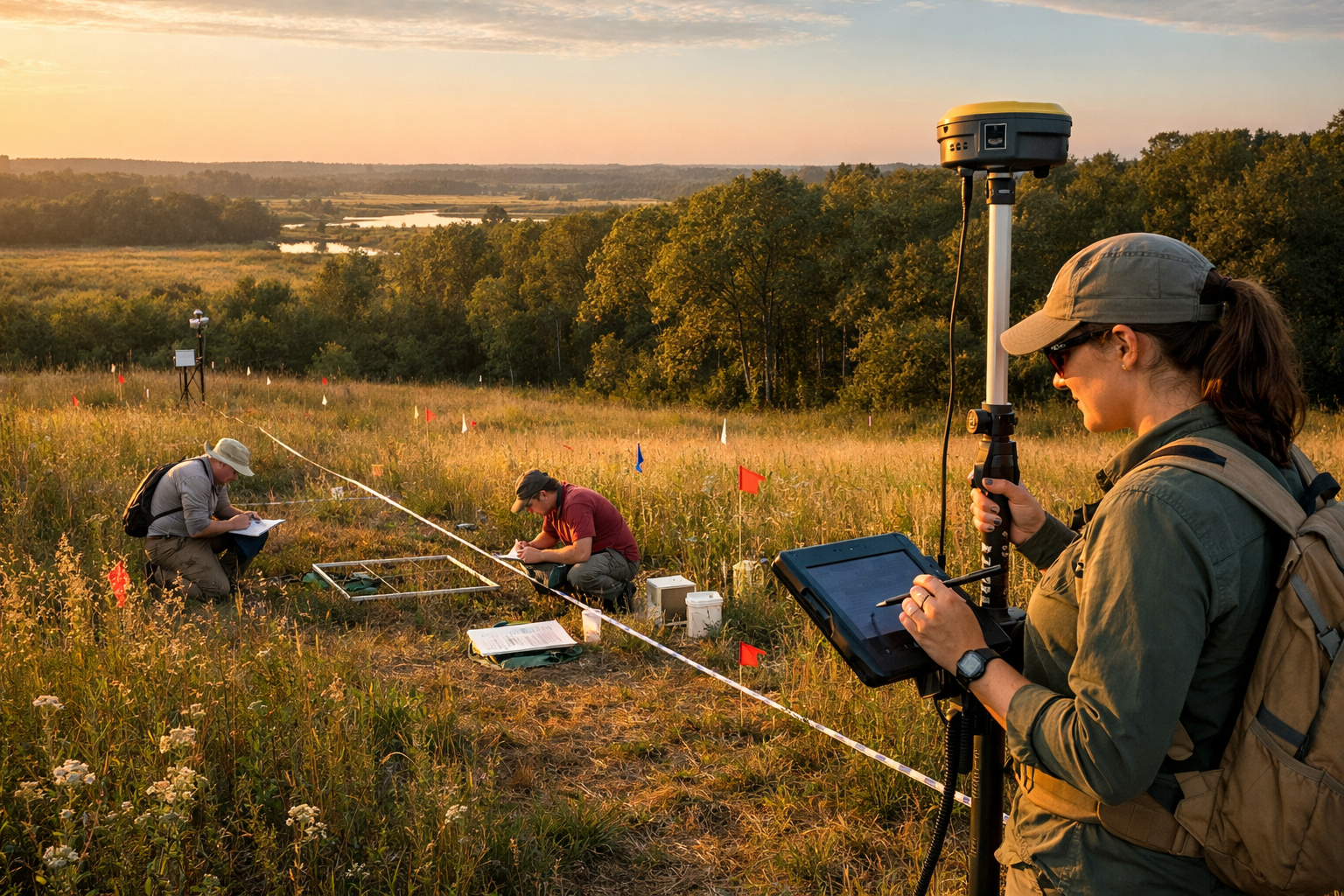
Landscape-scale reconnaissance: Begin with desktop analysis using aerial imagery, habitat maps, and species records. Field verification focuses on connectivity features, habitat distribution patterns, and landscape context. This broader perspective informs where intensive site surveys should focus effort.
Site-scale systematic surveys: Conduct comprehensive habitat mapping using Phase 1 and UK Habitat Classification systems. Establish survey transects and sampling points using stratified random design based on habitat heterogeneity. Document condition indicators for biodiversity unit calculations.
Habitat-scale intensive sampling: Within each habitat type, establish nested plots capturing vegetation structure, species composition, and environmental variables. Record indicator species and habitat quality metrics. This level provides the detailed data needed for accurate biodiversity net gain assessments.
Microhabitat-scale targeted surveys: Identify and sample discrete microhabitat features—deadwood accumulations, seepage zones, rock outcrops. Document specialist species associated with these features. This finest scale often reveals biodiversity value invisible at coarser resolutions.
Technology-Enabled Multi-Scale Data Collection
Modern survey technologies facilitate hierarchical assessment:
🔬 Remote sensing: LiDAR and multispectral imagery capture landscape and site-scale habitat structure, vegetation height diversity, and canopy complexity patterns[3].
🔬 GPS/GIS integration: Precise georeferencing links observations across scales, enabling spatial analysis of cross-scale relationships and connectivity.
🔬 Mobile data platforms: Field apps with hierarchical data structures streamline multi-scale recording, ensuring consistency and reducing transcription errors.
🔬 eDNA sampling: Environmental DNA methods efficiently sample biodiversity across scales, from landscape-scale water sampling to microhabitat soil cores.
🔬 Automated sensors: Camera traps, acoustic monitors, and environmental sensors provide continuous data complementing periodic surveys.
Data Integration and Analysis Frameworks
The value of hierarchical survey design emerges through integrated analysis that reveals cross-scale patterns:
Variance partitioning quantifies how much biodiversity variation occurs at each scale, identifying where habitat management interventions will have greatest impact.
Hierarchical modeling uses nested data structures to estimate species-habitat relationships while accounting for spatial autocorrelation across scales.
Scale-transition matrices document how species assemblages change across scale boundaries, revealing edge effects and transition zone values.
Connectivity metrics assess functional linkages between ecosystem scales, informing on-site versus off-site BNG delivery decisions.
Translating Multi-Scale Data to BNG Metrics
Hierarchical survey data enhances BNG calculations through:
-
Refined habitat distinctiveness: Multi-scale assessment reveals habitat heterogeneity that justifies higher distinctiveness classifications for complex sites.
-
Improved condition scores: Fine-scale data on structural diversity, species composition, and microhabitat features supports higher condition assessments.
-
Connectivity multipliers: Landscape-scale analysis documents ecological connectivity values that enhance biodiversity unit calculations.
-
Risk reduction: Comprehensive multi-scale baselines reduce uncertainty, minimizing the need for precautionary discounting in biodiversity unit valuations.
Urban biodiversity integration studies demonstrate how participatory approaches combined with multi-scale assessment frameworks improve conservation outcomes in complex landscapes[4]. These methods prove particularly valuable for developments in transitional zones or ecologically complex settings.
Challenges and Solutions in Hierarchical Survey Implementation
While Ecosystem Within Ecosystems: Hierarchical Survey Design for Multi-Scale Biodiversity Assessment in 2026 offers substantial benefits, implementation faces practical challenges that require strategic solutions.
Resource and Time Constraints
Challenge: Multi-scale surveys appear more resource-intensive than traditional single-scale approaches.
Solution: Hierarchical designs actually optimize resource allocation by concentrating intensive sampling where it matters most. Stratified sampling reduces redundant effort in homogeneous areas while ensuring adequate coverage of complex zones. Many organizations find that multi-scale approaches cost 15-25% more than basic surveys but provide 40-60% more decision-relevant information.
Data Complexity and Analysis Capacity
Challenge: Nested datasets require sophisticated analysis methods and statistical expertise.
Solution: Modern GIS platforms and ecological modeling software increasingly incorporate hierarchical analysis tools with user-friendly interfaces. Partnering with experienced biodiversity surveyors who understand multi-scale frameworks ensures appropriate analysis without requiring in-house expertise development.
Regulatory Alignment
Challenge: Current BNG guidance primarily addresses site-scale assessment, creating uncertainty about how multi-scale data integrates with statutory requirements.
Solution: Multi-scale surveys encompass all required site-scale data while adding complementary information. The hierarchical framework structures data collection to ensure compliance with standard requirements while capturing additional value. As regulatory frameworks evolve, early adopters of multi-scale approaches position themselves advantageously for emerging best practice standards.
Scale Selection Uncertainty
Challenge: Determining which scales matter for specific projects requires ecological expertise.
Solution: Begin with a rapid ecological characterization assessing habitat heterogeneity, landscape context, and known species of conservation concern. This preliminary assessment identifies relevant scales and informs survey design. For most developments, a three-scale framework (site, habitat, microhabitat) with landscape context analysis provides appropriate coverage.
Future Directions for Multi-Scale Biodiversity Assessment
The field of hierarchical biodiversity assessment continues evolving rapidly, with several developments shaping practice in 2026 and beyond:
Standardization efforts: Professional bodies and regulatory agencies are developing standardized protocols for multi-scale assessment, reducing methodological variation and improving comparability across projects.
Machine learning integration: AI-powered image analysis extracts multi-scale habitat structure data from drone imagery and satellite data, dramatically reducing field time requirements while maintaining data quality.
Citizen science expansion: Structured community engagement programs collect multi-scale biodiversity data across broader landscapes than professional surveys alone could achieve, particularly valuable for landscape-scale connectivity assessment.
Dynamic baseline approaches: Rather than static baseline snapshots, emerging frameworks incorporate temporal dynamics and climate trajectories, recognizing that ecosystem hierarchies shift over time.
Cross-sector adoption: Beyond development projects, multi-scale frameworks are being adopted for agricultural biodiversity assessment, forestry certification, and conservation planning, creating opportunities for integrated landscape-scale approaches.
Conclusion
Ecosystem Within Ecosystems: Hierarchical Survey Design for Multi-Scale Biodiversity Assessment in 2026 represents more than methodological refinement—it embodies a fundamental recognition that ecological reality operates across nested spatial scales, and our assessment frameworks must match this complexity. As biodiversity net gain requirements mature and conservation outcomes face increasing scrutiny, the limitations of single-scale surveys become increasingly apparent.
Hierarchical survey design offers a practical path forward, structuring data collection to capture the full spectrum of biodiversity patterns from landscape connectivity to microhabitat specialists. The approach optimizes resource allocation, improves baseline accuracy, and provides the detailed evidence needed for defensible BNG calculations and meaningful conservation outcomes.
For developers, planners, and landowners navigating 2026's biodiversity requirements, adopting multi-scale assessment frameworks delivers tangible benefits: more accurate baselines, reduced regulatory risk, optimized mitigation strategies, and enhanced conservation credibility. The initial investment in hierarchical survey design consistently proves worthwhile through improved project outcomes and streamlined approval processes.
Actionable Next Steps
✅ Evaluate your current projects: Review existing biodiversity surveys to identify whether single-scale approaches may be missing nested habitat complexity or microhabitat value.
✅ Engage experienced professionals: Partner with biodiversity surveyors who understand multi-scale frameworks to design hierarchical assessment protocols appropriate for your project context.
✅ Start with pilot applications: Implement hierarchical survey design on a representative project to quantify benefits and refine protocols before broader adoption.
✅ Integrate across project stages: Use multi-scale baseline data to inform biodiversity net gain strategies, habitat creation design, and long-term monitoring frameworks.
✅ Stay informed: Monitor emerging guidance and best practice developments as regulatory frameworks increasingly recognize multi-scale assessment value.
The ecosystems we seek to protect and enhance don't recognize arbitrary survey boundaries or single-scale simplifications. By embracing hierarchical survey design that honors ecological complexity, we create the foundation for biodiversity net gain that delivers genuine conservation outcomes—not just regulatory compliance, but meaningful contributions to the nested ecosystems that sustain both nature and human communities.
References
[1] 2041 210x – https://besjournals.onlinelibrary.wiley.com/doi/full/10.1111/2041-210X.14444
[2] Biodivconnect Selected Proposals – https://www.biodiversa.eu/wp-content/uploads/2026/03/BiodivConnect-Selected-Proposals.pdf
[3] Accepted Papers – https://2025.ieeeigarss.org/papers/accepted_papers.php
[4] 02697459.2026 – https://doi.org/10.1080/02697459.2026.2631637?urlappend=%3Futm_source%3Dresearchgate.net%26utm_medium%3Darticle
[5] riojournal – https://riojournal.com/article/129357/
