
Ocean darkening—declining light penetration across wide ocean regions—is reshaping marine food webs in ways scientists are only beginning to understand. As of 2026, researchers have documented that 21% of the global ocean has experienced significant darkening over the past two decades, threatening the foundation of marine ecosystems from kelp forests to coral reefs[2]. This emerging environmental challenge demands immediate attention from marine biologists, coastal developers, and environmental planners working to protect our ocean resources.
The phenomenon of Ocean Darkening and Marine Biodiversity Surveys: Monitoring Light Penetration Impacts on Coastal Ecosystems in 2026 represents a critical intersection of climate science, marine ecology, and conservation planning. Understanding how to measure and respond to reduced underwater light availability has become essential for anyone conducting biodiversity impact assessments in coastal zones.
Key Takeaways
🔑 Marine darkwaves—sudden episodes of underwater darkness lasting days to months—now pose a recognized threat to light-dependent marine ecosystems, with scientists establishing the first standardized monitoring framework in January 2026[1].
🔑 More than 9% of the ocean has experienced photic zone depth reductions exceeding 50 meters, forcing marine life that depends on light closer to the surface where competition for resources intensifies[2].
🔑 Climate change is accelerating the frequency and intensity of ocean darkening events through heavier rainfall, stronger storms, and increased sediment runoff from land-based activities[5].
🔑 Satellite monitoring combined with in-water sensors now enables comprehensive tracking of light penetration changes, providing essential data for marine biodiversity surveys and coastal ecosystem management[2].
🔑 Coastal development projects must now integrate light-penetration monitoring into environmental assessments to understand their cumulative impacts on marine ecosystems.
Understanding Ocean Darkening: The Science Behind Declining Light Penetration
Ocean darkening occurs when less sunlight reaches the underwater environment, fundamentally altering the conditions that marine life depends upon. The photic zone—the sunlit layer of ocean where light enables photosynthesis—is home to approximately 90% of all marine life[2]. When this critical zone shrinks, entire ecosystems face disruption.
What Causes Ocean Darkening?
Scientists have identified several primary drivers behind the darkening trend:
Natural and Human-Induced Factors:
- 🌊 Sediment runoff from agriculture, deforestation, and coastal development
- 🌧️ Increased rainfall bringing nutrients and organic matter into coastal waters
- 🦠 Algae blooms stimulated by nutrient pollution
- 🌪️ Storm events that stir up bottom sediments and increase water turbidity
- 🔬 Plankton community changes potentially linked to warming waters
Near coastlines, sediment runoff from human activities represents the primary culprit[4]. Agricultural practices, urban development, and deforestation all contribute to increased sediment loads entering coastal waters. When combined with climate change-driven increases in storm intensity, these factors create a perfect storm for ocean darkening.
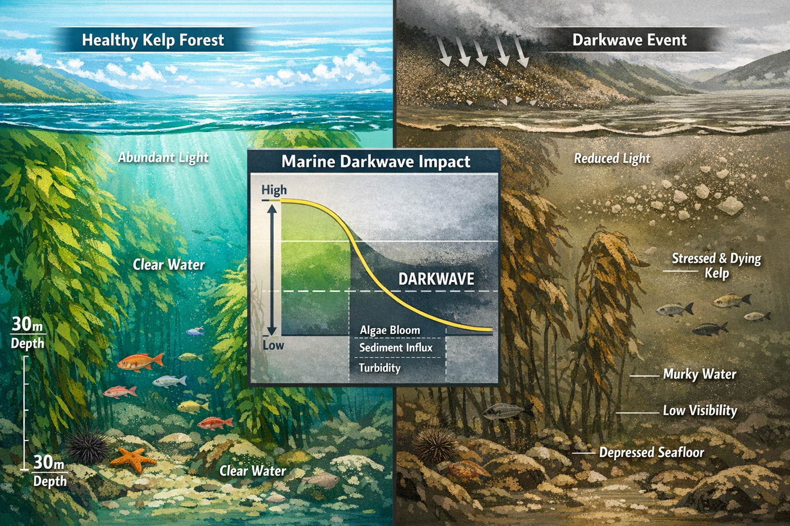
The Marine Darkwave Phenomenon
In January 2026, researchers at UC Santa Barbara identified and named a specific type of ocean darkening event: marine darkwaves[1]. These are sudden episodes of extreme light reduction that can last from days to months, dramatically impacting underwater ecosystems.
"Even short periods of reduced light can impair photosynthesis in kelp forests, seagrass and corals." — François Thoral, UC Santa Barbara[1]
Marine darkwaves don't just affect plant life. They also influence the behavior of fish, sharks, and marine mammals, altering feeding patterns and movement when visibility drops[1][5]. This cascading effect demonstrates how light availability serves as a fundamental organizing principle for marine ecosystems.
Ocean Darkening and Marine Biodiversity Surveys: Essential Monitoring Methods for 2026
Effective monitoring of ocean darkening requires a combination of satellite technology, in-water sensors, and standardized measurement protocols. The comprehensive framework established in early 2026 provides marine surveyors with the tools needed to document light penetration changes systematically[1].
Satellite-Based Detection Systems
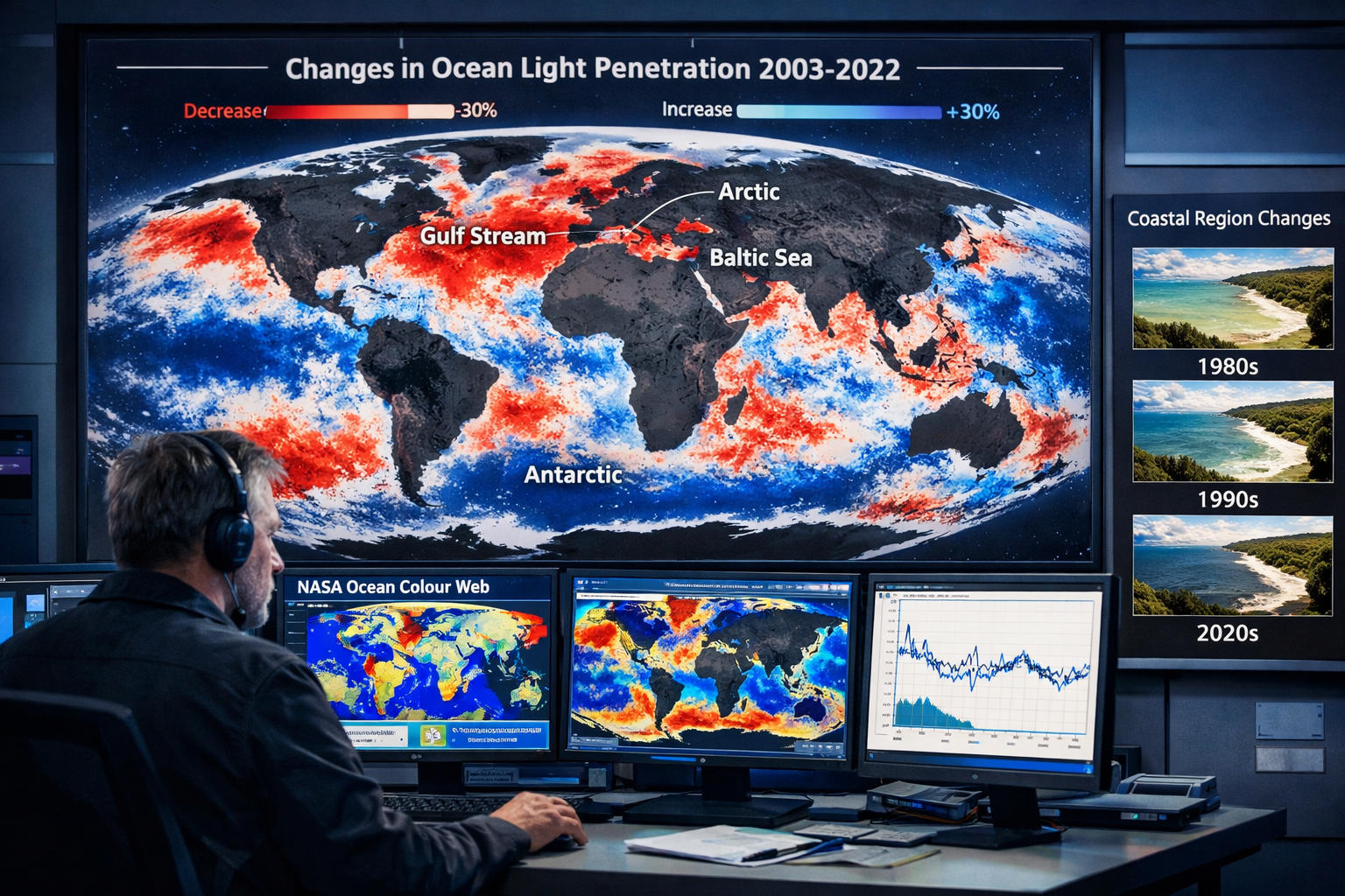
Researchers utilize NASA's Ocean Colour Web data to track surface changes across the global ocean[2]. This approach involves:
- Breaking the ocean into 9-kilometer pixels for detailed observation
- Monitoring surface color changes that indicate water clarity
- Applying algorithms to estimate light penetration depth
- Tracking changes over time to identify darkening trends
The satellite data reveals striking patterns. Between 2003 and 2022, researchers documented that while 21% of the ocean darkened, approximately 10% (more than 37 million square kilometers) actually became lighter[2]. However, the darkening trend dominates globally, particularly in critical regions.
Geographic Hotspots Requiring Priority Monitoring
High-Priority Monitoring Zones:
| Region | Darkening Severity | Primary Causes |
|---|---|---|
| Gulf Stream | Extreme | Climate-driven oceanographic changes |
| Arctic waters | Severe | Warming, ice melt, increased runoff |
| Antarctic regions | Severe | Climate change impacts |
| Baltic Sea | Significant | Agricultural runoff, nutrient loading |
| Coastal zones globally | Variable | Sediment runoff, development |
These geographic hotspots represent areas where biodiversity surveys must now incorporate light-penetration monitoring as a standard practice.
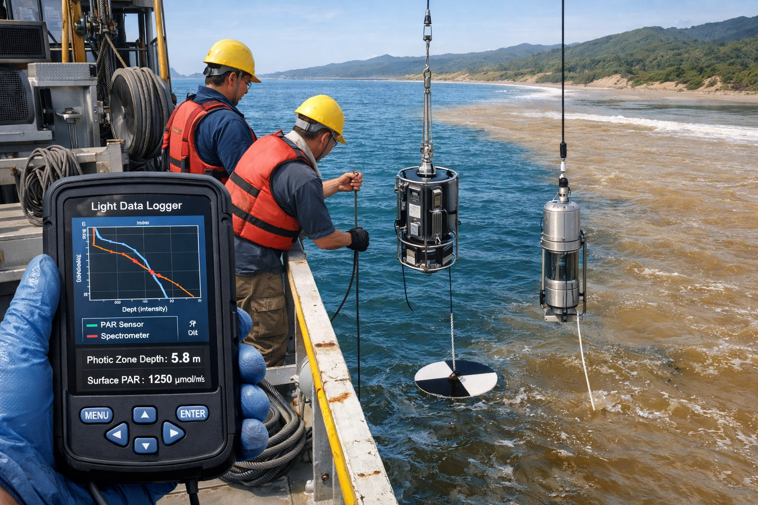
In-Water Measurement Techniques
The standardized framework developed using 16 years of data from Santa Barbara's Coastal Long Term Ecological Research Site and 10 years from New Zealand's Hauraki Gulf provides specific protocols[1]:
Essential Measurement Parameters:
- 📊 Photosynthetically Active Radiation (PAR) at multiple depths
- 🌡️ Water temperature and salinity profiles
- 🔍 Turbidity measurements using nephelometers
- 📏 Secchi disk depth for visual clarity assessment
- 🧪 Chlorophyll-a concentrations indicating phytoplankton levels
- 🎯 Spectral light measurements across different wavelengths
These measurements allow researchers to calculate the photic zone depth—the depth at which light intensity falls to 1% of surface levels. Tracking changes in this critical boundary provides early warning of ecosystem stress.
Integrating Light Monitoring into Biodiversity Assessments
For developers and environmental consultants conducting coastal projects, integrating light-penetration monitoring into biodiversity impact assessments has become essential in 2026. This integration ensures projects account for cumulative impacts on marine ecosystems.
Key Integration Steps:
- Baseline Documentation: Establish pre-project light penetration profiles
- Seasonal Variation: Monitor across seasons to capture natural variability
- Impact Prediction: Model how project activities might affect water clarity
- Mitigation Planning: Design sediment control measures based on light requirements
- Long-term Monitoring: Continue measurements post-construction to verify predictions
This approach aligns with broader biodiversity net gain principles, ensuring coastal development doesn't inadvertently contribute to ecosystem decline through reduced light availability.
Ecosystem Impacts and Biodiversity Responses to Reduced Light Penetration
The consequences of ocean darkening extend far beyond simple visibility reduction. When light availability declines, fundamental shifts occur throughout marine food webs, affecting everything from microscopic algae to apex predators.
Impacts on Foundation Species
Kelp Forests:
Kelp forests rank among the most productive ecosystems on Earth, but they depend entirely on adequate light for photosynthesis. Marine darkwave events can cause:
- ⚠️ Reduced growth rates and reproductive success
- ⚠️ Increased susceptibility to disease and storm damage
- ⚠️ Forest thinning or complete die-off in severe cases
- ⚠️ Loss of habitat for hundreds of dependent species
Seagrass Meadows:
These underwater flowering plants provide critical nursery habitat for fish and sequester vast amounts of carbon. Darkening threatens their survival through:
- 📉 Decreased photosynthetic capacity
- 📉 Reduced root and rhizome growth
- 📉 Increased vulnerability to erosion
- 📉 Meadow fragmentation and habitat loss
Coral Reefs:
While coral bleaching from warming waters receives more attention, reduced light also stresses coral-algae symbiosis:
- 🪸 Impaired zooxanthellae photosynthesis
- 🪸 Reduced energy available for coral growth
- 🪸 Decreased calcification rates
- 🪸 Cumulative stress when combined with warming
Cascading Effects Through Food Webs
When foundation species decline, ripple effects spread throughout ecosystems. More than 9% of the ocean has experienced photic zone reductions exceeding 50 meters[2], forcing profound ecological adjustments:
Vertical Compression:
Light-dependent organisms must move closer to the surface, creating:
- Increased competition for food and space
- Higher predation risk in crowded surface waters
- Altered species interactions and community structure
- Potential local extinctions of specialized species
Behavioral Modifications:
Fish, sharks, and marine mammals adjust their behavior when underwater visibility drops[1][5]:
- Changed feeding times and locations
- Altered migration patterns
- Modified predator-prey dynamics
- Disrupted reproductive behaviors
Quantifying Biodiversity Losses
The scale of potential biodiversity impact becomes clear when considering that the photic zone hosts 90% of marine life[2]. A 50-meter reduction in photic zone depth in a region previously supporting life to 200 meters represents a 25% habitat loss for light-dependent species.
Vulnerability Assessment Priorities:
| Ecosystem Type | Vulnerability Level | Monitoring Priority |
|---|---|---|
| Shallow kelp forests | ⭐⭐⭐⭐⭐ Critical | Immediate, continuous |
| Seagrass meadows | ⭐⭐⭐⭐⭐ Critical | Immediate, continuous |
| Coral reefs | ⭐⭐⭐⭐ High | Quarterly minimum |
| Rocky reef communities | ⭐⭐⭐ Moderate | Bi-annual |
| Deep soft-bottom habitats | ⭐⭐ Low | Annual |
These priorities should guide resource allocation for marine biodiversity monitoring programs in coastal regions experiencing darkening trends.
Climate Change Amplification
Climate change acts as a threat multiplier for ocean darkening[5]. Projected increases in:
- 🌧️ Rainfall intensity and frequency
- 🌪️ Storm severity
- 🌊 Coastal erosion
- 🏗️ Development pressure on coastal zones
All these factors will likely increase sediment and nutrient loading to coastal waters, accelerating darkening trends. This creates an urgent need for proactive monitoring and management strategies.
Implementing Light-Penetration Monitoring in Coastal Development Projects
For developers, architects, and planners working in coastal zones, understanding and mitigating impacts on underwater light availability has become a regulatory and ethical imperative in 2026. Projects that increase sediment runoff or alter coastal hydrology can contribute to ocean darkening, with long-lasting ecosystem consequences.
Regulatory Context and Best Practices
While specific regulations vary by jurisdiction, the growing recognition of ocean darkening as an environmental threat means that biodiversity assessments increasingly require light-penetration analysis for coastal projects.
Project Types Requiring Enhanced Scrutiny:
- 🏗️ Coastal construction and marina development
- 🚢 Port expansion and dredging operations
- 🌾 Agricultural development in coastal watersheds
- 🏘️ Urban development affecting runoff patterns
- 🛣️ Infrastructure projects near waterways
Sediment Control as Primary Mitigation
Since sediment runoff represents the primary driver of coastal darkening[4], effective sediment control measures provide the most direct mitigation approach:
Engineering Controls:
- Silt fences and sediment barriers during construction
- Vegetated buffer strips between development and water
- Retention ponds and settling basins
- Permeable surfaces to reduce runoff velocity
- Erosion control blankets on exposed soil
Operational Best Practices:
- Timing construction to avoid high-rainfall periods
- Progressive stabilization of disturbed areas
- Regular inspection and maintenance of control measures
- Turbidity monitoring in adjacent waters
- Rapid response protocols for control failures
Designing Biodiversity-Positive Coastal Projects
Forward-thinking developers can go beyond mitigation to create projects that actively improve water clarity and support marine biodiversity. This approach aligns with biodiversity net gain principles increasingly required for development projects.
Enhancement Strategies:
- 🌱 Coastal wetland restoration to filter runoff
- 🌳 Native vegetation planting in riparian zones
- 🪨 Living shorelines instead of hard armoring
- 💧 Green infrastructure for stormwater management
- 🦪 Shellfish reef creation for water filtration
These measures not only reduce project impacts but can result in net improvements to water clarity and ecosystem health.
Monitoring Requirements and Protocols
Comprehensive monitoring programs should span the project lifecycle:
Pre-Construction Phase:
- Establish baseline light penetration profiles
- Document existing water quality conditions
- Survey marine communities in potentially affected areas
- Identify sensitive receptors (kelp beds, seagrass, reefs)
Construction Phase:
- Real-time turbidity monitoring
- Weekly light penetration measurements
- Rapid response to exceedances
- Photo-documentation of control measures
Post-Construction Phase:
- Quarterly light penetration surveys (first year)
- Annual monitoring (years 2-5)
- Benthic community assessments
- Comparison to baseline and reference sites
Case Study Applications
Consider a hypothetical marina expansion project in a region with existing kelp forest habitat. A comprehensive approach would include:
- Baseline Assessment: Six months of pre-construction light monitoring establishing natural variability
- Impact Prediction: Modeling sediment dispersion from dredging activities
- Adaptive Management: Establishing turbidity thresholds that trigger work stoppages
- Compensatory Measures: Funding kelp restoration in nearby degraded areas
- Long-term Stewardship: Five-year monitoring commitment with performance standards
This approach demonstrates how developers can benefit nature while completing necessary coastal infrastructure projects.
Future Directions: Technology and Policy Innovations for 2026 and Beyond
As understanding of ocean darkening advances, new technologies and policy frameworks are emerging to address this challenge more effectively.
Emerging Monitoring Technologies
Autonomous Systems:
- 🤖 Underwater drones with integrated light sensors
- 🛰️ Improved satellite resolution and algorithm accuracy
- 📱 Citizen science apps for coastal water clarity reporting
- 🔬 Environmental DNA sampling to track biodiversity responses
Data Integration Platforms:
The standardized framework developed in 2026[1] enables global data sharing and comparison. Cloud-based platforms now allow researchers worldwide to:
- Upload light penetration measurements
- Compare local trends to global patterns
- Access predictive models for darkwave events
- Coordinate monitoring efforts across jurisdictions
Policy and Planning Innovations
Watershed-Scale Management:
Recognizing that ocean darkening often originates from land-based activities, progressive jurisdictions are implementing:
- Integrated coastal zone management plans
- Agricultural best management practice requirements
- Development standards that account for cumulative runoff impacts
- Payment for ecosystem services programs rewarding landowners who reduce sediment export
Marine Spatial Planning:
Light availability is increasingly incorporated into marine spatial planning decisions:
- Zoning high-clarity areas for sensitive species protection
- Restricting activities that increase turbidity near critical habitats
- Establishing marine protected areas based partly on light conditions
- Requiring light-impact assessments for offshore development
The Role of Biodiversity Surveyors
Professional biodiversity surveyors play a crucial role in documenting and responding to ocean darkening. Their expertise in conducting comprehensive assessments positions them to:
✅ Establish standardized monitoring protocols for local conditions
✅ Train developers and consultants in light-penetration assessment
✅ Provide independent verification of project impacts
✅ Contribute data to regional and global monitoring networks
✅ Advise on mitigation and enhancement strategies
Research Priorities
Critical knowledge gaps remain that require focused research attention:
Ecological Thresholds:
- What light levels represent tipping points for different ecosystems?
- How do multiple stressors (warming + darkening) interact?
- Can ecosystems adapt to gradually declining light availability?
Restoration Potential:
- How quickly do ecosystems recover when light conditions improve?
- What restoration interventions are most effective?
- Can assisted migration help species adapt to darker conditions?
Socioeconomic Dimensions:
- What are the economic costs of ecosystem degradation from darkening?
- How do coastal communities depend on clear-water ecosystems?
- What policy mechanisms most effectively reduce sediment pollution?
Conclusion: Charting a Course Through Darkening Waters
Ocean darkening represents one of the most significant yet underappreciated threats facing marine ecosystems in 2026. With 21% of the global ocean experiencing declining light penetration[2] and climate change poised to accelerate this trend[5], the time for comprehensive monitoring and decisive action is now.
The establishment of standardized monitoring frameworks in early 2026[1] provides the scientific foundation needed to track this phenomenon systematically. However, translating scientific understanding into effective conservation action requires engagement from multiple stakeholders—researchers, policymakers, developers, and coastal communities.
Actionable Next Steps
For Marine Researchers and Surveyors:
- 📊 Adopt the standardized marine darkwave monitoring framework
- 🌐 Contribute data to global monitoring networks
- 📝 Publish regional assessments to build the evidence base
- 🤝 Collaborate across disciplines to understand ecosystem responses
For Developers and Consultants:
- 🔍 Integrate light-penetration assessment into biodiversity impact assessments
- 🛡️ Implement robust sediment control measures
- 💚 Consider enhancement opportunities that improve water clarity
- 📈 Commit to long-term monitoring of project impacts
For Policymakers and Planners:
- 📜 Develop regulations that address cumulative darkening impacts
- 🗺️ Incorporate light availability into marine spatial planning
- 💰 Fund monitoring networks and research programs
- 🌊 Implement watershed-scale management approaches
For Coastal Property Owners:
- 🌱 Maintain vegetated buffers along waterways
- 🏡 Use green infrastructure for stormwater management
- 🚫 Minimize fertilizer and pesticide use
- 📞 Contact biodiversity professionals for site-specific guidance
The challenge of ocean darkening is significant, but not insurmountable. By combining advanced monitoring technology, standardized protocols, effective policy frameworks, and committed stewardship, we can protect the light-dependent ecosystems that form the foundation of ocean productivity. The comprehensive approach to Ocean Darkening and Marine Biodiversity Surveys: Monitoring Light Penetration Impacts on Coastal Ecosystems in 2026 outlined in this article provides a roadmap for action.
As marine darkwaves become more frequent and intense, our response must be equally robust. Every coastal development project, every land-use decision, and every policy choice represents an opportunity to either exacerbate or alleviate this growing threat. The choice—and the responsibility—belongs to all of us who depend on healthy, productive ocean ecosystems.
References
[1] Scientists identify new threat to ocean life: Marine darkwaves – https://www.sciencedaily.com/releases/2026/01/260114084115.htm
[2] A Darkening Ocean Could Have A Profound Impact On Marine Life – https://oceanographicmagazine.com/news/a-darkening-ocean-could-have-a-profound-impact-on-marine-life/
[3] Marine darkwaves: A new threat to ocean life – https://www.eurekalert.org/news-releases/1085194
[4] Ocean Darkening – https://www.weforum.org/videos/ocean-darkening/
[5] New threat to marine life: Marine darkwaves – https://phys.org/news/2026-01-threat-marine-darkwaves-ocean-life.html
