
The future of biodiversity measurement has arrived. In March 2026, Proceedings of the National Academy of Sciences published a groundbreaking perspective piece outlining nine radical changes that will transform how surveyors measure, monitor, and quantify biodiversity.[1][2] These recommendations, emerging from the 2025 US-UK Scientific Forum on Measuring Biodiversity, aren't just academic theory—they're practical transformations that surveyors must implement now to deliver accurate biodiversity net gain assessments and support the Kunming–Montreal Global Biodiversity Framework.[3]
For surveyors working on development projects in 2026, understanding the Nine Measurement Transformations for Surveyors: Implementing PNAS Recommendations in 2026 Biodiversity Assessments means embracing cutting-edge technologies like environmental DNA (eDNA), genomics, acoustic monitoring, and artificial intelligence while maintaining scientific rigor and data integrity.
Key Takeaways
- 🔬 Technology integration is essential: eDNA, genomics, acoustic monitoring, remote sensing, and AI must work together to capture comprehensive biodiversity data
- 📊 Standardization and calibration ensure new monitoring technologies align with existing long-term datasets for consistent, comparable results
- 🌍 Critical data gaps in tropical regions and temporal monitoring require urgent attention through emerging technologies and increased capacity
- 🤝 Collaborative frameworks bringing together field ecologists, Indigenous knowledge holders, citizen scientists, and data specialists are non-negotiable
- ✅ Effectiveness measurement must be built into assessment designs to verify that conservation actions actually work
Understanding the PNAS Framework for Biodiversity Measurement
The PNAS perspective piece represents a fundamental shift in how the scientific community approaches biodiversity assessment. Published in Volume 123, Issue 10 of Proceedings of the National Academy of Sciences of the USA, this collaborative work brings together international experts to address urgent challenges in measuring Earth's biological diversity.[1][4]
Why These Transformations Matter Now
Biodiversity loss continues at unprecedented rates, yet our ability to measure and monitor these changes has lagged behind policy needs. The Kunming–Montreal Global Biodiversity Framework demands quantifiable evidence of conservation effectiveness, making accurate measurement more critical than ever.[3]
For surveyors conducting biodiversity impact assessments, these nine transformations provide a roadmap for modernizing field practices while maintaining scientific credibility. The recommendations directly address real-world challenges: data gaps, technological inconsistencies, valuation of field work, and the need for resilient monitoring systems.
The Nine Measurement Transformations: A Practical Guide
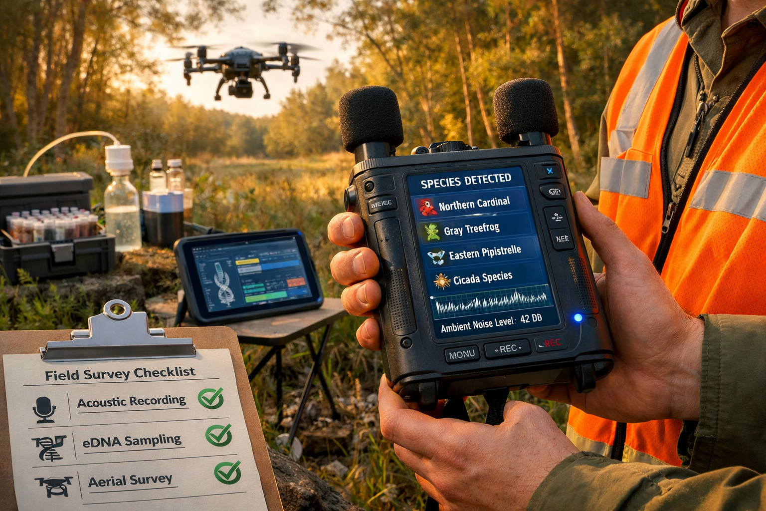
Transformation 1: Technology Integration 🔧
The Recommendation: Capitalize on novel technology's ability to integrate multiple data sources, including advances in citizen science, image recognition, acoustic monitoring, environmental DNA, genomics, remote sensing, and AI.[1][2]
Practical Implementation for Surveyors:
Surveyors must move beyond single-method approaches. A comprehensive 2026 biodiversity assessment integrates:
- Environmental DNA (eDNA) sampling from soil, water, and air to detect species presence without direct observation
- Acoustic monitoring devices that continuously record and identify species through vocalizations
- Image recognition software analyzing camera trap data and drone imagery
- Remote sensing data providing habitat structure and vegetation health metrics
- Citizen science platforms expanding geographic coverage and temporal frequency
Surveyor Checklist:
✅ Invest in multi-technology equipment packages
✅ Train team members on eDNA collection protocols
✅ Deploy acoustic monitors for 24/7 species detection
✅ Integrate drone surveys with ground-truthing
✅ Establish citizen science partnerships for ongoing monitoring
Transformation 2: Standardization 📋
The Recommendation: Agree to standardized methods for data collection across different biodiversity monitoring systems to ensure comparability and interoperability.[1][2]
Practical Implementation for Surveyors:
Standardization enables data sharing and comparison across projects, regions, and time periods. This transformation requires:
- Adopting industry-standard protocols for each measurement technology
- Using consistent taxonomic references and nomenclature
- Recording metadata comprehensively (date, time, weather, observer, equipment specifications)
- Formatting data outputs according to agreed-upon schemas
- Participating in quality assurance programs and inter-laboratory comparisons
When conducting a biodiversity net gain assessment, standardized methods ensure that baseline and post-development measurements are directly comparable, providing defensible evidence of net gain achievement.
Surveyor Checklist:
✅ Follow national and international standardized protocols
✅ Document all methodological details
✅ Use standardized data templates
✅ Participate in proficiency testing programs
✅ Align with UK Biodiversity Net Gain statutory requirements
Transformation 3: Technology Calibration ⚙️
The Recommendation: Ensure new monitoring technologies are calibrated with existing long-term datasets to maintain consistency and validate new measurement approaches.[1][2]
Practical Implementation for Surveyors:
New technologies offer exciting capabilities, but they must be validated against established methods to ensure accuracy. Calibration involves:
- Running parallel surveys using both traditional and novel methods
- Comparing detection rates between eDNA and visual surveys
- Validating acoustic identifications with expert verification
- Ground-truthing remote sensing classifications with field observations
- Documenting conversion factors between measurement approaches
Surveyor Checklist:
✅ Conduct validation studies comparing new and traditional methods
✅ Maintain overlap periods when transitioning technologies
✅ Document detection probabilities for each method
✅ Establish site-specific calibration factors
✅ Publish calibration results to support broader adoption
Transformation 4: Data Gap Resolution 🌍
The Recommendation: Fill critical geographic and temporal data gaps by deploying emerging technologies and increasing monitoring capacity, with explicit emphasis on tropical regions where biodiversity is highest but monitoring is sparse.[1][2]
Practical Implementation for Surveyors:
While tropical regions face the most severe data gaps, UK surveyors encounter similar challenges in undersampled habitats and time periods. Addressing gaps requires:
- Prioritizing surveys in data-deficient regions and habitat types
- Increasing temporal frequency through automated monitoring
- Deploying technology in previously inaccessible locations
- Building local capacity for ongoing monitoring
- Establishing baseline data in under-surveyed areas
For developers working toward 10% biodiversity net gain, understanding baseline conditions in data-poor areas is essential for accurate impact quantification.
Surveyor Checklist:
✅ Identify data gaps in project areas
✅ Deploy automated monitoring for continuous data collection
✅ Survey during multiple seasons to capture temporal variation
✅ Access difficult terrain using drones and remote sensors
✅ Contribute data to national biodiversity databases
Transformation 5: AI Safeguards 🛡️
The Recommendation: Create living, safeguarded databases of trusted biodiversity information to mitigate risks from AI-generated hallucinations or false data that could compromise decision-making.[1][2]
Practical Implementation for Surveyors:
As AI becomes integral to species identification and data analysis, protecting data integrity is paramount. Safeguarding requires:
- Verifying AI identifications with expert review
- Using trusted reference databases with validated specimens
- Implementing quality control protocols for AI-generated data
- Maintaining audit trails showing data provenance
- Flagging uncertain identifications for human verification
Surveyor Checklist:
✅ Use AI tools with transparent training data sources
✅ Implement expert review for critical identifications
✅ Document confidence levels for AI-generated results
✅ Maintain reference collections for validation
✅ Report data quality metrics in assessment reports
Transformation 6: Data Valuation 💰
The Recommendation: Establish mechanisms to ensure that data generation work—including by citizen scientists and field researchers—is appropriately valued and credited.[1][2]
Practical Implementation for Surveyors:
Recognizing the value of biodiversity data collection supports sustainable monitoring programs. This transformation includes:
- Properly compensating field surveyors and data collectors
- Crediting citizen scientists who contribute observations
- Acknowledging Indigenous knowledge holders for their contributions
- Establishing fair data sharing agreements
- Recognizing data collection as valuable intellectual work
Understanding the cost of biodiversity units helps developers appreciate the value of comprehensive assessment work.
Surveyor Checklist:
✅ Ensure fair compensation for field work
✅ Credit all data contributors in reports
✅ Establish clear data ownership agreements
✅ Support citizen science programs financially
✅ Advocate for appropriate project budgets
Transformation 7: Indigenous Knowledge Integration 🤝
The Recommendation: Ensure respectful, equitable incorporation of Indigenous Knowledge systems alongside scientific measurements in biodiversity assessments.[1][2]
Practical Implementation for Surveyors:
While UK contexts differ from regions with Indigenous populations, the principle of incorporating local and traditional ecological knowledge applies universally. Integration involves:
- Consulting local communities with long-term land connections
- Respecting traditional knowledge about species and habitats
- Establishing collaborative partnerships with knowledge holders
- Ensuring equitable benefit sharing from assessment outcomes
- Recognizing multiple knowledge systems as complementary
Surveyor Checklist:
✅ Engage local communities early in project planning
✅ Document traditional ecological knowledge respectfully
✅ Establish collaborative research agreements
✅ Share findings with knowledge contributors
✅ Integrate diverse knowledge systems in assessment reports
Transformation 8: Effectiveness Measurement 📈
The Recommendation: Design biodiversity measurements to enable quantification of whether conservation actions and interventions are actually effective.[1][2]
Practical Implementation for Surveyors:
Measuring conservation effectiveness requires baseline data, intervention documentation, and post-implementation monitoring. This transformation demands:
- Establishing clear baseline conditions before development
- Defining measurable objectives for conservation actions
- Implementing monitoring protocols that track progress toward goals
- Using control sites for comparison where possible
- Analyzing trends to determine intervention success
For projects involving off-site or on-site delivery of biodiversity net gain, effectiveness measurement proves whether habitat creation and enhancement actually deliver promised ecological benefits.
Surveyor Checklist:
✅ Collect comprehensive baseline data
✅ Define specific, measurable conservation targets
✅ Establish monitoring schedules for intervention sites
✅ Include control sites in study designs
✅ Report effectiveness metrics in assessment updates
Transformation 9: System Resilience 🔄
The Recommendation: Increase the technical and societal resilience of global biodiversity datasets to withstand technological disruptions and social changes.[1][2]
Practical Implementation for Surveyors:
Resilient monitoring systems continue functioning despite technology failures, funding changes, or social disruptions. Building resilience requires:
- Maintaining multiple data backups in different locations
- Using open data formats that remain accessible long-term
- Establishing redundant monitoring systems
- Building diverse funding sources for ongoing monitoring
- Creating institutional partnerships that outlast individual projects
Surveyor Checklist:
✅ Back up data in multiple secure locations
✅ Use non-proprietary data formats
✅ Establish long-term monitoring partnerships
✅ Diversify funding sources for ongoing surveys
✅ Document methods thoroughly for future replication
Implementing PNAS Recommendations in Your 2026 Assessments

Building Collaborative Frameworks
The PNAS authors emphasize that achieving these transformations requires "radical new collaborations" between computer scientists, engineers, molecular biologists, data scientists, field ecologists, citizen scientists, Indigenous peoples, policymakers, and local communities.[1][2]
For surveyors, this means:
Expanding Your Professional Network:
- Partner with molecular biology labs for eDNA analysis
- Collaborate with AI specialists for automated species identification
- Work with remote sensing experts for habitat mapping
- Engage citizen science coordinators for expanded monitoring
- Connect with local ecological knowledge holders
Establishing Multi-Disciplinary Teams:
| Role | Contribution to Assessment |
|---|---|
| Field Ecologist | Traditional survey methods, habitat assessment |
| Molecular Biologist | eDNA sampling, genomic analysis |
| Data Scientist | AI model development, statistical analysis |
| Remote Sensing Specialist | Drone surveys, satellite imagery analysis |
| Citizen Science Coordinator | Public engagement, expanded monitoring |
| Local Knowledge Holder | Historical context, species behavior insights |
| Conservation Planner | Effectiveness metrics, intervention design |
Technology Investment Priorities for 2026
Surveyors implementing the Nine Measurement Transformations for Surveyors: Implementing PNAS Recommendations in 2026 Biodiversity Assessments should prioritize:
- eDNA sampling kits and laboratory partnerships
- Acoustic monitoring devices with AI-powered species identification
- Drone platforms with multispectral sensors
- Mobile data collection apps with standardized templates
- Cloud-based data management systems with backup protocols
- AI-assisted image recognition software for camera trap analysis
- Quality assurance tools for data validation
Integration with UK Biodiversity Net Gain Requirements
The PNAS recommendations align perfectly with UK statutory requirements for biodiversity net gain. When conducting assessments for developers, these transformations enhance:
- Baseline accuracy through multi-technology surveys
- Data defensibility through standardized, calibrated methods
- Monitoring effectiveness through automated, continuous data collection
- Stakeholder confidence through transparent, validated results
- Long-term accountability through resilient data systems
Developers seeking guidance on creating biodiversity plans benefit from surveyors who implement these advanced measurement approaches.
Overcoming Implementation Challenges
Challenge 1: Technology Costs
Solution: Start with high-impact, lower-cost technologies like acoustic monitors and citizen science platforms. Build eDNA and genomic capacity through laboratory partnerships rather than in-house facilities. Justify technology investments by demonstrating improved accuracy and efficiency.
Challenge 2: Training Requirements
Solution: Invest in professional development for team members. Attend workshops on new technologies. Establish mentoring relationships with early adopters. Join professional networks sharing implementation experiences.
Challenge 3: Data Management Complexity
Solution: Adopt cloud-based platforms designed for biodiversity data. Use standardized data templates from the start. Establish clear data management protocols before fieldwork begins. Allocate sufficient time and budget for data quality control.
Challenge 4: Client Understanding
Solution: Educate clients about the value of comprehensive assessments. Demonstrate how advanced methods reduce uncertainty and risk. Show case studies where technology integration improved outcomes. Connect assessment quality to regulatory compliance and project success.
Challenge 5: Regulatory Alignment
Solution: Stay current with evolving guidance from regulatory bodies. Participate in consultations on assessment standards. Document how new methods meet or exceed regulatory requirements. Build relationships with planning authorities to discuss innovative approaches.
Case Study: Applying the Nine Transformations
Consider a hypothetical 50-hectare development site in southern England with mixed woodland, grassland, and wetland habitats:
Traditional Approach:
- Multiple seasonal visits for species surveys
- Visual and auditory identification only
- Limited temporal coverage
- Single-observer bias
- Data gaps for nocturnal and cryptic species
Transformed Approach Using PNAS Recommendations:
- Technology Integration: Deploy acoustic monitors, collect eDNA samples from soil and water, conduct drone surveys with multispectral imaging, engage citizen scientists for expanded coverage
- Standardization: Use UK Habitat Classification System, follow eDNA protocols from National Biodiversity Network, standardize all data formats
- Calibration: Run parallel traditional and eDNA surveys, validate acoustic identifications with expert review, ground-truth remote sensing classifications
- Gap Resolution: Survey during multiple seasons including winter, deploy night-vision cameras, sample previously inaccessible wetland areas
- AI Safeguards: Use validated AI models for species identification, implement expert review for rare species, maintain audit trails
- Data Valuation: Fairly compensate field team, credit citizen science contributors, establish data sharing agreements
- Knowledge Integration: Consult local naturalist groups, incorporate historical records, engage community in monitoring
- Effectiveness Measurement: Establish clear baseline, define measurable targets for habitat creation, implement 30-year monitoring plan
- Resilience: Back up data in multiple locations, use open formats, establish institutional partnerships for long-term monitoring
Result: Comprehensive baseline assessment with higher species detection rates, defensible data for regulatory submission, robust monitoring framework for demonstrating net gain achievement.
Future Directions: Beyond 2026
The Nine Measurement Transformations for Surveyors: Implementing PNAS Recommendations in 2026 Biodiversity Assessments represent current best practice, but biodiversity measurement will continue evolving. Emerging trends include:
- Real-time biodiversity monitoring through sensor networks
- Predictive modeling using AI to forecast biodiversity responses
- Blockchain technology for data provenance and integrity
- Integration with climate monitoring to understand biodiversity-climate interactions
- Automated species identification approaching expert-level accuracy
- Satellite-based biodiversity indicators providing global coverage
Surveyors who embrace these transformations now will be well-positioned to adopt future innovations while maintaining scientific rigor and data quality.
Conclusion
The Nine Measurement Transformations for Surveyors: Implementing PNAS Recommendations in 2026 Biodiversity Assessments provide a comprehensive framework for modernizing biodiversity measurement. These aren't optional enhancements—they're essential transformations that enable surveyors to meet the demands of contemporary conservation policy, deliver defensible assessments, and contribute to global biodiversity monitoring efforts.[1][2]
For surveyors working on development projects, implementing these recommendations means:
✅ More accurate baseline assessments through technology integration
✅ Defensible data through standardization and calibration
✅ Comprehensive coverage by filling critical data gaps
✅ Protected integrity through AI safeguards
✅ Fair recognition of data collection work
✅ Inclusive approaches incorporating diverse knowledge systems
✅ Demonstrated effectiveness of conservation interventions
✅ Long-term reliability through resilient monitoring systems
Next Steps for Surveyors
- Audit current practices against the nine transformations
- Identify priority improvements based on project needs and resources
- Invest in technology and training for high-impact transformations
- Build collaborative partnerships with specialists in complementary fields
- Pilot integrated approaches on upcoming projects
- Document lessons learned and share with professional community
- Advocate for appropriate budgets that support comprehensive assessments
- Stay engaged with evolving guidance and best practices
The biodiversity crisis demands measurement systems that match the scale and urgency of the challenge. By implementing these PNAS recommendations, surveyors become part of the solution—delivering the high-quality data needed to halt biodiversity loss and demonstrate conservation success.
For developers, planners, and landowners seeking expert guidance on implementing these advanced assessment approaches, contact biodiversity specialists who understand both the scientific foundations and practical applications of these transformative recommendations.
The future of biodiversity measurement is here. The question isn't whether to adopt these transformations—it's how quickly surveyors can implement them to support effective conservation in 2026 and beyond.
References
[1] Nine Changes Needed To Deliver A Radical Transformation In Biodiv – https://research.bangor.ac.uk/en/publications/nine-changes-needed-to-deliver-a-radical-transformation-in-biodiv/
[2] Pnas – https://www.pnas.org/doi/10.1073/pnas.2519345123
[3] Pnas – https://www.pnas.org/doi/10.1073/pnas.2519347123
[4] nationalacademies – https://www.nationalacademies.org/publications/29211?publication_date%5Bquick%5D=past_10_years
