
Wildlife populations across the globe face an unprecedented crisis—but the solution may not be what conservationists expected. A groundbreaking 2026 study analyzing over 3,000 vertebrate populations has revealed a critical insight: addressing individual threats in isolation simply doesn't work. Coordinated Threat Mitigation in Wildlife Surveys: Bayesian Modeling for 2026 Biodiversity Net Gain represents the cutting edge of conservation science, combining advanced statistical techniques with multi-threat intervention strategies to reverse biodiversity decline and achieve meaningful ecological gains.
The implications for developers, planners, and conservation professionals are profound. As Biodiversity Net Gain requirements become mandatory across development projects, understanding how multiple threats interact—and how to model their combined impacts—is no longer optional. It's essential for compliance, effective conservation, and genuine environmental improvement.
Key Takeaways
- 🔬 Multi-threat approach required: Single-threat interventions fail to reverse population declines; coordinated mitigation of habitat loss, climate change, pollution, invasive species, and disease is essential for recovery
- 📊 Bayesian models provide superior accuracy: Spatial Bayesian hierarchical models outperform traditional methods, especially in data-sparse regions, revealing fine-grained population trends invisible to conventional approaches
- 🎯 Priority threats identified: If resources are limited, reducing overexploitation, habitat loss, or climate change impacts delivers the greatest global conservation benefits
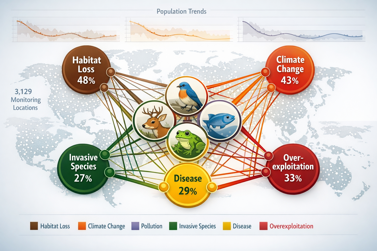
- 🌍 Evidence-based at scale: Analysis of 3,129 vertebrate populations worldwide between 1950 and 2020 provides the first global, population-level proof of how interacting threats accelerate biodiversity loss
- ✅ Practical application for BNG: These modeling techniques enable developers to simulate intervention scenarios, prioritize actions, and demonstrate measurable biodiversity gains with greater confidence
Understanding the Multi-Threat Crisis in Wildlife Populations
The traditional conservation model focused on single, high-profile threats—primarily habitat destruction and overexploitation. However, research published in Science Advances in 2026 has fundamentally challenged this approach. By analyzing 3,129 vertebrate populations worldwide between 1950 and 2020, scientists discovered that populations exposed to combinations of threats decline significantly faster than those affected by single pressures [1].
The Interacting Threats Framework
Wildlife populations don't exist in controlled laboratory conditions. In the real world, they face multiple simultaneous pressures:
- Habitat loss and degradation 🏗️
- Climate change impacts 🌡️
- Pollution (chemical, plastic, noise, light) ☠️
- Invasive species 🦎
- Disease and pathogens 🦠
- Overexploitation (hunting, fishing, harvesting) 🎣
The Bristol University study revealed that these threats don't simply add together—they multiply their negative effects. A population facing habitat fragmentation might cope reasonably well. The same population dealing with climate-driven temperature shifts might also survive. But when both pressures occur simultaneously, along with pollution or disease, the combined impact creates a downward spiral that single-intervention strategies cannot reverse [1].
"Halting predicted vertebrate declines requires tackling multiple drivers of biodiversity loss. Our analysis shows that coordinated mitigation is not just preferable—it's necessary for population recovery."
— P. Capdevila et al., Science Advances (2026)
Why Single-Threat Interventions Fail
Conservation projects historically focused resources on the most obvious threat. Protecting habitat for an endangered species seemed logical. Creating pollution controls made sense for contaminated waterways. Yet populations continued declining.
The 2026 research explains why: removing one threat while others persist rarely achieves stable or recovering populations [1]. A bird species might gain protected nesting habitat, but if invasive predators, pesticide exposure, and climate-driven food source shifts continue unchecked, the population still trends downward.
For developers working to achieve 10% Biodiversity Net Gain, this finding is crucial. Habitat creation alone—while important—won't deliver lasting biodiversity gains unless accompanied by coordinated threat mitigation across multiple categories.
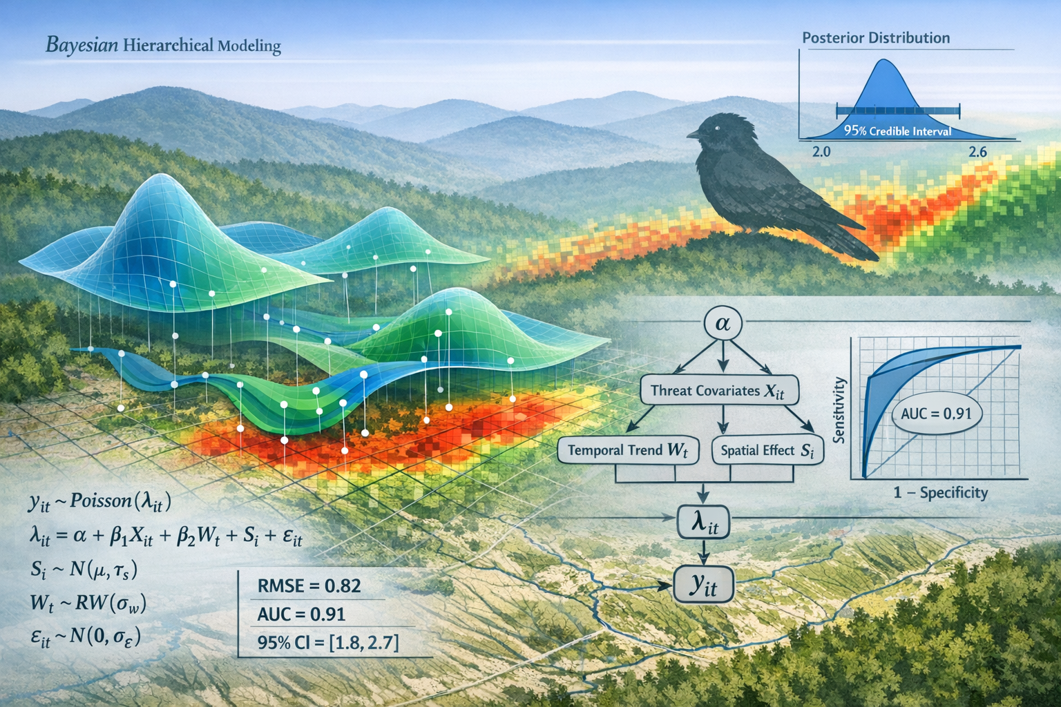
Bayesian Modeling: The Statistical Foundation for Coordinated Threat Mitigation
Coordinated Threat Mitigation in Wildlife Surveys: Bayesian Modeling for 2026 Biodiversity Net Gain relies on sophisticated statistical techniques that allow conservationists to understand complex ecological relationships and predict intervention outcomes. Bayesian modeling has emerged as the gold standard for this work.
What Makes Bayesian Models Different?
Unlike traditional statistical approaches, Bayesian methods:
- Incorporate prior knowledge: Previous studies, expert opinion, and ecological theory inform the model, making predictions more realistic
- Quantify uncertainty explicitly: Results include probability distributions, not just point estimates, showing confidence levels for predictions
- Update continuously: As new survey data arrives, models refine their predictions without starting from scratch
- Handle missing data effectively: Gaps in monitoring don't invalidate the entire analysis
Researchers used Bayesian statistical models to simulate 'what-if' scenarios, estimating how vertebrate populations might respond if threats were reduced or removed individually or collectively [1]. This scenario-testing capability is transformative for conservation planning.
Spatial Bayesian Hierarchical Models: Superior Predictive Power
Recent validation studies using data from major North American monitoring programs—including the Breeding Bird Survey (BBS), Christmas Bird Count, and Migrating Shorebird Surveys—demonstrated that spatially explicit Bayesian hierarchical models achieve higher out-of-sample predictive accuracy compared to non-spatial approaches [2].
The advantages are particularly striking in:
- Data-sparse regions where conventional methods struggle
- Locations with divergent local trends that differ from range-wide patterns
- Fine-grained spatial analysis revealing population dynamics invisible to traditional methods
For example, spatial Bayesian models identified recent population increases for Eastern Whip-poor-will (Antrostomus vociferus) along the Appalachian Mountains—a trend completely missed by non-spatial analyses [2].
Practical Application: Building Multi-Threat Survey Protocols
How does this translate to real-world wildlife surveys for Biodiversity Net Gain assessments? The process involves several key steps:
| Survey Phase | Bayesian Modeling Application | Threat Mitigation Integration |
|---|---|---|
| Baseline Assessment | Establish prior probability distributions for species presence, abundance, and trends | Document all observed threats (habitat quality, pollution sources, invasive species, climate vulnerabilities) |
| Data Collection | Use hierarchical models to account for detection probability and observer variation | Record threat intensity scores for each identified pressure |
| Spatial Analysis | Apply spatial autocorrelation to share information across neighboring sites | Map threat overlap zones where multiple pressures coincide |
| Scenario Modeling | Simulate intervention outcomes under different threat-reduction combinations | Prioritize coordinated actions based on predicted population responses |
| Monitoring & Updating | Incorporate new data to refine predictions and reduce uncertainty | Adjust mitigation strategies as model confidence improves |
This structured approach ensures that biodiversity impact assessments capture the full complexity of ecological systems rather than oversimplifying to single-threat scenarios.
Implementing Coordinated Threat Mitigation in 2026 Biodiversity Net Gain Projects
The theoretical framework is clear: multiple threats require coordinated responses, and Bayesian models provide the analytical tools. But how do developers, planners, and ecologists implement Coordinated Threat Mitigation in Wildlife Surveys: Bayesian Modeling for 2026 Biodiversity Net Gain in actual projects?
Priority Mitigation Hierarchy: Where to Focus First
The 2026 Bristol study identified a critical finding for resource-limited projects: if only one threat category can be prioritized, reducing overexploitation, habitat loss, or climate change impacts would likely deliver the greatest global conservation benefits [1].
However, the research emphasizes that this hierarchy is a last resort. Optimal outcomes require addressing multiple threats simultaneously. For UK development projects, this translates to:
Tier 1 Priorities (Highest Impact)
- Habitat restoration and enhancement: Native species planting, structural diversity, connectivity corridors
- Climate adaptation measures: Microclimate management, water retention, heat island mitigation
- Pollution controls: Runoff management, lighting design, noise barriers, chemical restrictions
Tier 2 Priorities (Essential Supporting Actions)
- Invasive species management: Prevention protocols, early detection systems, removal programs
- Disease risk reduction: Habitat hygiene, population density management, vector control
- Sustainable resource use: Responsible material sourcing, minimal disturbance protocols
Developing Site-Specific Threat Profiles
Every development site has a unique threat signature. A Biodiversity Net Gain report should include:
Threat Assessment Matrix:
- Identify all present and potential threats across categories
- Score threat intensity (low, moderate, high, critical)
- Map spatial distribution of each threat
- Analyze threat interactions using Bayesian network models
- Predict population responses to various mitigation scenarios
This systematic approach replaces guesswork with evidence-based decision-making. Rather than assuming habitat creation will suffice, planners can model whether additional interventions—pollution controls, invasive species barriers, climate-resilient planting—will meaningfully improve outcomes.
Bayesian Scenario Simulation: Testing Before Implementing
One of the most powerful applications of Bayesian modeling is predictive scenario testing. Before committing resources to specific interventions, ecologists can simulate outcomes:
Example Scenario Analysis:
- Baseline: Current trajectory with no intervention (e.g., -2.3% annual population decline)
- Scenario A: Habitat restoration only (+0.5% annual change)
- Scenario B: Habitat restoration + pollution controls (+1.8% annual change)
- Scenario C: Habitat restoration + pollution controls + invasive species management (+3.2% annual change)
- Scenario D: Full coordinated mitigation across all threat categories (+4.7% annual change)
The model provides probability distributions for each scenario, showing not just the expected outcome but the range of uncertainty. This allows planners to make informed decisions about which interventions justify their costs.
Integration with Biodiversity Metric Calculations
The UK Biodiversity Metric 4.0 calculates biodiversity units based on habitat distinctiveness, condition, and strategic significance. Coordinated threat mitigation directly improves habitat condition scores, which are central to achieving net gain.
Condition Assessment Criteria Enhanced by Threat Mitigation:
- Physical structure: Improved by habitat restoration and climate adaptation
- Function: Enhanced by pollution controls and invasive species management
- Cover of trees/shrubs: Supported by climate-resilient species selection
- Disturbance: Reduced through noise/light pollution controls
- Evidence of negative indicators: Minimized by comprehensive threat mitigation
When developers implement coordinated threat mitigation protocols informed by Bayesian modeling, they achieve higher condition scores, more biodiversity units, and greater confidence in long-term outcomes. This approach also reduces the risk of failing to achieve promised gains, which could trigger regulatory penalties or reputational damage.
Monitoring and Adaptive Management
Bayesian models excel at adaptive management because they update predictions as new monitoring data becomes available. A robust BNG delivery plan should include:
✅ Baseline surveys using standardized protocols
✅ Year 1-5 monitoring to track early intervention effectiveness
✅ Year 10, 20, 30 monitoring for long-term trend verification
✅ Bayesian model updates incorporating new data to refine predictions
✅ Adaptive interventions adjusted based on observed outcomes versus predictions
This creates a learning system that improves over time, rather than a static plan that may or may not deliver intended results.
Case Study Applications and Real-World Examples
North American Bird Monitoring: Proof of Concept
The validation of spatial Bayesian models using Breeding Bird Survey data across North America provides compelling evidence of their practical utility [2]. These models:
- Identified localized population increases missed by traditional methods
- Performed significantly better in data-sparse regions
- Revealed fine-grained spatial patterns essential for conservation targeting
- Enabled finer-scale stratification for decision-making
For UK applications, this suggests that Bayesian approaches could dramatically improve the accuracy of protected species surveys, particularly for:
- Bats: Where detection probability varies with weather, season, and survey effort
- Great crested newts: Where presence/absence data is complicated by life stage and habitat use
- Breeding birds: Where populations show localized trends within broader ranges
- Invertebrates: Where data is often sparse and patchy
Applying Global Insights to UK Development Projects
The findings from the 3,129-population global analysis directly inform UK conservation strategy. British wildlife faces the same suite of interacting threats:
- Habitat loss: Ongoing through development, agricultural intensification, and infrastructure
- Climate change: Shifting temperature and precipitation patterns affecting phenology and distributions
- Pollution: Agricultural runoff, urban contaminants, light and noise pollution
- Invasive species: Non-native predators, competitors, and diseases
- Disease: Emerging pathogens affecting amphibians, birds, and mammals
A development project in southern England might support declining farmland bird populations. A single-threat approach might create wildflower margins (habitat intervention). But Bayesian modeling could reveal that coordinated mitigation addressing pesticide use (pollution), hedgerow connectivity (habitat), and predator management (invasive species) would deliver 3-4 times greater population benefits.
This is the practical power of Coordinated Threat Mitigation in Wildlife Surveys: Bayesian Modeling for 2026 Biodiversity Net Gain: transforming theoretical ecology into actionable conservation that measurably improves outcomes.
Challenges and Considerations for Implementation
Data Requirements and Expertise
Bayesian modeling requires:
- Sufficient baseline data: While models handle sparse data better than alternatives, some minimum information is necessary
- Statistical expertise: Implementing hierarchical Bayesian models requires specialized knowledge
- Computational resources: Complex spatial models can be computationally intensive
- Ongoing monitoring: Models improve with data updates, requiring long-term commitment
For smaller projects, full Bayesian analysis may not be feasible. However, the principles of coordinated threat mitigation remain applicable regardless of analytical sophistication. Even simple threat checklists and prioritization frameworks deliver better outcomes than single-threat approaches.
Cost-Benefit Considerations
Coordinated mitigation costs more upfront than single interventions. Developers must weigh:
- Higher initial investment in comprehensive threat assessment and multi-intervention strategies
- Greater certainty of achieving BNG targets and avoiding compliance failures
- Reduced long-term risk of ecological failure requiring remediation
- Enhanced reputation for delivering genuine environmental benefits
For many projects, particularly larger developments, the cost of biodiversity units through statutory credits or off-site provision may exceed the incremental cost of comprehensive on-site threat mitigation.
Regulatory Alignment and Future Directions
As BNG regulations mature, expect increasing emphasis on:
- Evidence-based intervention design rather than generic prescriptions
- Quantified threat assessments integrated into metric calculations
- Predictive modeling to demonstrate likely outcomes before approval
- Long-term monitoring to verify that predicted gains materialize
Early adopters of Bayesian modeling and coordinated threat mitigation approaches will be well-positioned as regulatory expectations evolve. The 2026 research provides the scientific foundation for these emerging standards.
Conclusion
Coordinated Threat Mitigation in Wildlife Surveys: Bayesian Modeling for 2026 Biodiversity Net Gain represents a fundamental shift in conservation science and practice. The evidence is unambiguous: single-threat interventions cannot reverse global biodiversity decline. Only coordinated approaches addressing multiple interacting pressures achieve stable or recovering wildlife populations.
For developers, planners, and conservation professionals working within the UK's Biodiversity Net Gain framework, this research provides both a challenge and an opportunity. The challenge is to move beyond simplistic habitat creation toward comprehensive threat assessment and multi-intervention strategies. The opportunity is to deliver measurably better ecological outcomes with greater confidence and reduced long-term risk.
Actionable Next Steps
For Developers:
- Commission comprehensive threat assessments as part of biodiversity impact assessments
- Request Bayesian scenario modeling to compare intervention strategies
- Budget for coordinated mitigation across multiple threat categories
- Implement robust monitoring programs that enable adaptive management
For Planners:
5. Require evidence-based threat analysis in BNG submissions
6. Prioritize applications demonstrating coordinated mitigation approaches
7. Support monitoring and adaptive management conditions in approvals
For Ecologists:
8. Develop expertise in Bayesian statistical modeling techniques
9. Integrate multi-threat frameworks into survey protocols and reporting
10. Collaborate across disciplines to address pollution, climate, and invasive species alongside habitat
The path to genuine biodiversity recovery is clear. By combining advanced Bayesian modeling with coordinated threat mitigation strategies, the conservation community can move from managing decline to achieving measurable, lasting ecological gains. The science is settled—now comes implementation.
For expert guidance on implementing these approaches in your development projects, explore our comprehensive BNG services and developer guidance resources.
References
[1] Wildlife Decline – https://www.bristol.ac.uk/cabot/news/2026/wildlife-decline.html
[2] academic.oup – https://academic.oup.com/condor/article/126/1/duad056/7454691
