
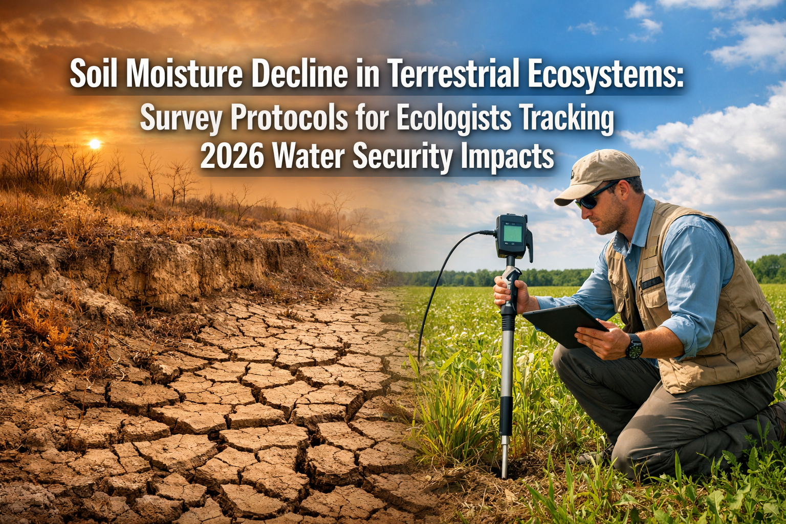
The ground beneath our feet is drying out—and fast. Recent research confirms that global soil moisture has entered a sharp and potentially permanent decline, with devastating implications for terrestrial ecosystems, biodiversity, and water security. As 2026 unfolds, ecologists face an urgent challenge: integrating soil moisture monitoring into biodiversity surveys to accurately assess ecosystem health and ensure meaningful conservation outcomes. Understanding Soil Moisture Decline in Terrestrial Ecosystems: Survey Protocols for Ecologists Tracking 2026 Water Security Impacts has become essential for professionals working in environmental assessment and conservation planning.
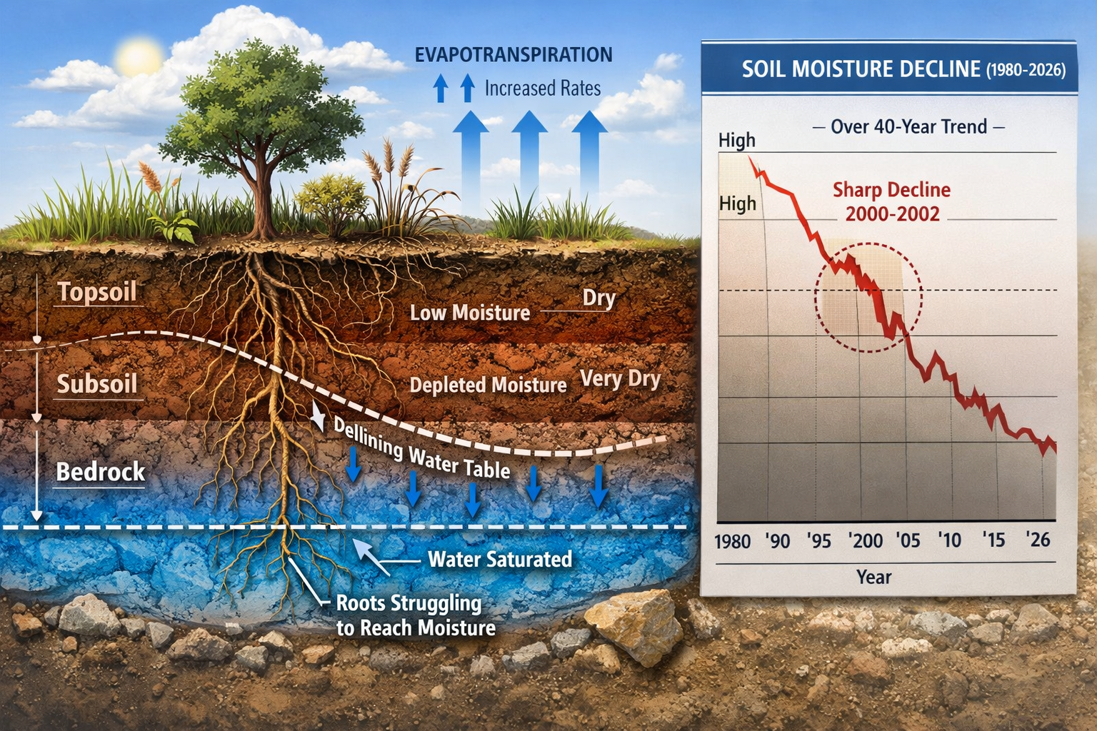
Over the past 40 years, terrestrial water storage has plummeted, with research published in Science revealing an unprecedented loss of 1,614 gigatonnes of water during the critical 2000-2002 period alone [1]. This water didn't simply disappear—it flowed into oceans, contributing to sea level rise while leaving soils increasingly parched. The implications for biodiversity assessments, particularly those conducted for biodiversity impact assessments, are profound and demand immediate protocol updates.
Key Takeaways
- 🌍 Global soil moisture has declined sharply over 40 years, with 1,614 gigatonnes lost between 2000-2002, marking a potentially permanent shift in Earth's water cycle [1][2]
- 📊 Nearly 50% of greening areas experience simultaneous soil drying, creating a "greening-drying paradox" that challenges traditional ecosystem health indicators [3]
- 🔬 Groundwater depletion accounts for 68% of terrestrial water storage loss, making comprehensive water monitoring essential for accurate biodiversity surveys [4]
- 📋 Standardized survey protocols must now integrate soil moisture measurements alongside traditional biodiversity metrics to capture true ecosystem condition
- ⚠️ Current hydrological models are inadequate, requiring substantial improvements to factor agricultural intensification and vegetation dynamics in semi-arid regions [2]
Understanding the Scale of Soil Moisture Decline in Terrestrial Ecosystems
The Science Behind Global Water Loss
The evidence is stark and scientifically robust. Research from The Hong Kong Polytechnic University, published in the prestigious journal Science, documented a continuous decline in global soil moisture that shows no signs of recovery through 2021 [1]. This isn't a temporary drought cycle—it represents a fundamental restructuring of Earth's hydrological systems.
Between 2000 and 2016, an additional 1,009 gigatonnes of water disappeared from terrestrial storage [2]. To put this in perspective, this volume of water is sufficient to raise global sea levels measurably, and the physical redistribution of this mass actually caused Earth's pole to shift 58 centimeters toward 93° East Longitude between 2003 and 2011 [1].
The Greening-Drying Paradox
One of the most counterintuitive findings complicates ecosystem assessment: 65.82% of global vegetated areas are greening while simultaneously experiencing soil moisture decline [3]. This "greening-drying paradox" means that traditional visual assessments of vegetation health can be profoundly misleading.
Research published in Communications Earth & Environment found that nearly 50% of greening areas witnessed significant soil drying, particularly in water-scarce regions including:
- Central Africa – Savanna and woodland ecosystems
- Central Asia – Steppe and grassland habitats
- Eastern Australia – Semi-arid shrublands
- Mid-to-high latitude Europe – Temperate grasslands and agricultural zones [3]
This paradox occurs because vegetation can initially respond positively to increased atmospheric CO₂ (the "fertilization effect") and extended growing seasons, even as underlying soil moisture steadily declines. Eventually, however, the water deficit catches up, leading to ecosystem collapse.
Key Drivers of Terrestrial Water Storage Loss
Understanding what's causing soil moisture decline is essential for developing effective survey protocols. The primary contributors to terrestrial water storage (TWS) loss on drying continental areas are [4]:
| Water Source | Percentage of TWS Loss | Primary Causes |
|---|---|---|
| Groundwater | 68% | Over-extraction, irrigation, reduced recharge |
| Surface Water | 18% | Increased evaporation, altered precipitation |
| Soil Moisture | 9% | Evaporative demand, vegetation uptake |
| Snow Water Equivalent | 5% | Reduced snowpack, earlier melt |
The atmosphere's increasing "thirst" for water—technically called evaporative demand—has been rising globally over the past two decades due to warming temperatures [2]. This means that even when precipitation occurs, soils cannot retain moisture as effectively as they historically did. The water evaporates more quickly, preventing recovery from dry periods.
Agricultural Intensification Compounds the Problem
Human activities significantly accelerate natural drying trends. Agricultural irrigation in regions such as northeast China and the western United States, combined with global agricultural expansion into semi-arid areas, further diminishes soil moisture reserves [1]. This creates a feedback loop: as natural water sources decline, irrigation increases, which depletes groundwater, which reduces soil moisture recharge capacity.
For ecologists conducting surveys for development projects, this means that biodiversity net gain assessments must now account for both direct habitat impacts and indirect water security implications.
Survey Protocols for Ecologists Tracking 2026 Water Security Impacts
Integrating Soil Moisture Monitoring into Biodiversity Surveys
Traditional biodiversity surveys focus on species counts, habitat quality indicators, and vegetation structure. However, the 2026 reality demands a more comprehensive approach that incorporates soil moisture as a fundamental baseline metric. Ecologists need field-ready protocols that integrate seamlessly with existing survey methodologies while providing actionable water security data.
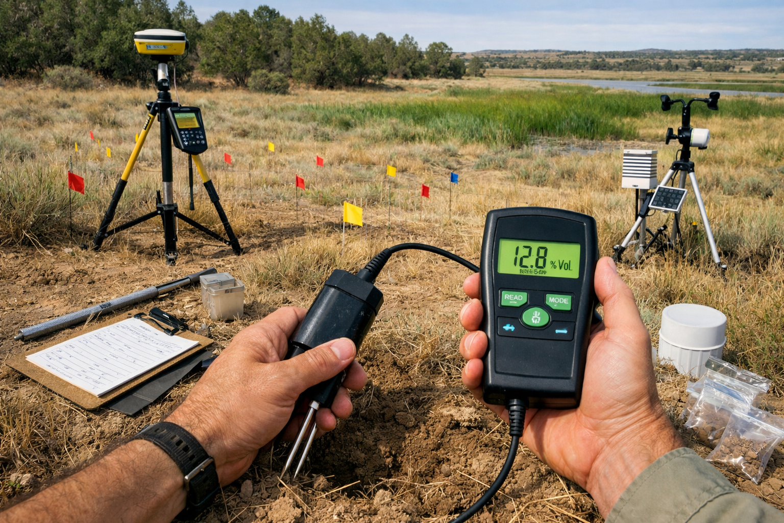
Essential Equipment for Soil Moisture Assessment
Modern soil moisture monitoring requires specific tools that balance accuracy with field practicality:
Direct Measurement Devices:
- 📱 Time Domain Reflectometry (TDR) probes – Provide instant volumetric water content readings with ±2% accuracy
- 🔧 Frequency Domain Reflectometry (FDR) sensors – Cost-effective alternative for large-scale surveys
- 💧 Tensiometers – Measure soil water tension, indicating plant-available moisture
- 🌡️ Gravimetric sampling kits – Laboratory-verified moisture content through soil sample drying
Supporting Equipment:
- 📍 GPS units with sub-meter accuracy for precise survey point documentation
- 📊 Digital data loggers for continuous monitoring stations
- 🗺️ Soil augers for profile sampling at multiple depths
- 📝 Field tablets with survey protocol software integration
Standardized Sampling Protocols
Consistency across surveys is critical for meaningful comparison and long-term monitoring. The following protocol provides a foundation that ecologists can adapt to specific ecosystem types:
Pre-Survey Planning Phase
- Desktop Assessment – Review historical climate data, soil maps, and existing moisture records for the survey area
- Stratification – Divide the survey area into homogeneous units based on soil type, vegetation, topography, and land use
- Sample Point Determination – Establish systematic sampling grids with minimum density of one point per hectare for detailed assessments
- Baseline Data Collection – Gather recent precipitation records, temperature data, and evapotranspiration estimates
Field Survey Protocol
Step 1: Site Documentation 📸
- Record GPS coordinates (±1m accuracy)
- Photograph vegetation structure and soil surface
- Note recent disturbance, erosion, or water ponding
- Document weather conditions at time of survey
Step 2: Soil Moisture Measurement 💧
- Take readings at standardized depths: 0-10cm, 10-30cm, 30-60cm
- Conduct three replicate measurements per point, averaging results
- Record soil temperature alongside moisture readings
- Note soil texture and any impediments to probe insertion
Step 3: Contextual Ecological Data 🌱
- Assess vegetation vigor using standardized indices
- Identify indicator species sensitive to moisture stress
- Evaluate root exposure or soil cracking
- Document proximity to water sources
Step 4: Quality Control ✅
- Calibrate equipment daily against known standards
- Cross-reference TDR readings with gravimetric samples (10% of points)
- Flag anomalous readings for verification
- Record equipment serial numbers and calibration dates
Temporal Considerations for Accurate Assessment
Soil moisture varies dramatically across seasons and weather events. A single snapshot survey provides limited value. Ecologists must implement temporal sampling strategies that capture meaningful variability:
Seasonal Survey Schedule:
- 🌸 Spring (March-May) – Post-winter recharge assessment
- ☀️ Summer (June-August) – Peak evaporative stress period
- 🍂 Autumn (September-November) – Pre-winter baseline
- ❄️ Winter (December-February) – Dormant season storage (where applicable)
Minimum Survey Frequency:
- Baseline assessments – Quarterly measurements for one full year
- Monitoring programs – Bi-annual surveys at consistent seasonal timing
- Post-intervention tracking – Monthly measurements for first year, then quarterly
Data Interpretation and Reporting Standards
Raw soil moisture data becomes meaningful only through proper interpretation within ecological context. Ecologists should report findings using standardized frameworks:
Moisture Classification System:
| Moisture Level | Volumetric Water Content | Ecological Implications |
|---|---|---|
| Saturated | >40% | Potential anaerobic conditions, limited root growth |
| Field Capacity | 25-40% | Optimal plant-available water |
| Moderate Stress | 15-25% | Reduced plant productivity, sensitive species affected |
| Severe Stress | 5-15% | Significant vegetation stress, biodiversity impacts |
| Permanent Wilting | <5% | Plant death, ecosystem degradation |
Essential Reporting Elements:
- Spatial Distribution Maps – Color-coded moisture zones across survey area
- Temporal Trend Analysis – Graphs showing seasonal and inter-annual patterns
- Comparative Benchmarks – Reference to regional averages and historical baselines
- Biodiversity Correlations – Statistical relationships between moisture and species richness
- Water Security Risk Assessment – Classification of ecosystem vulnerability
- Recommendations – Management interventions and monitoring priorities
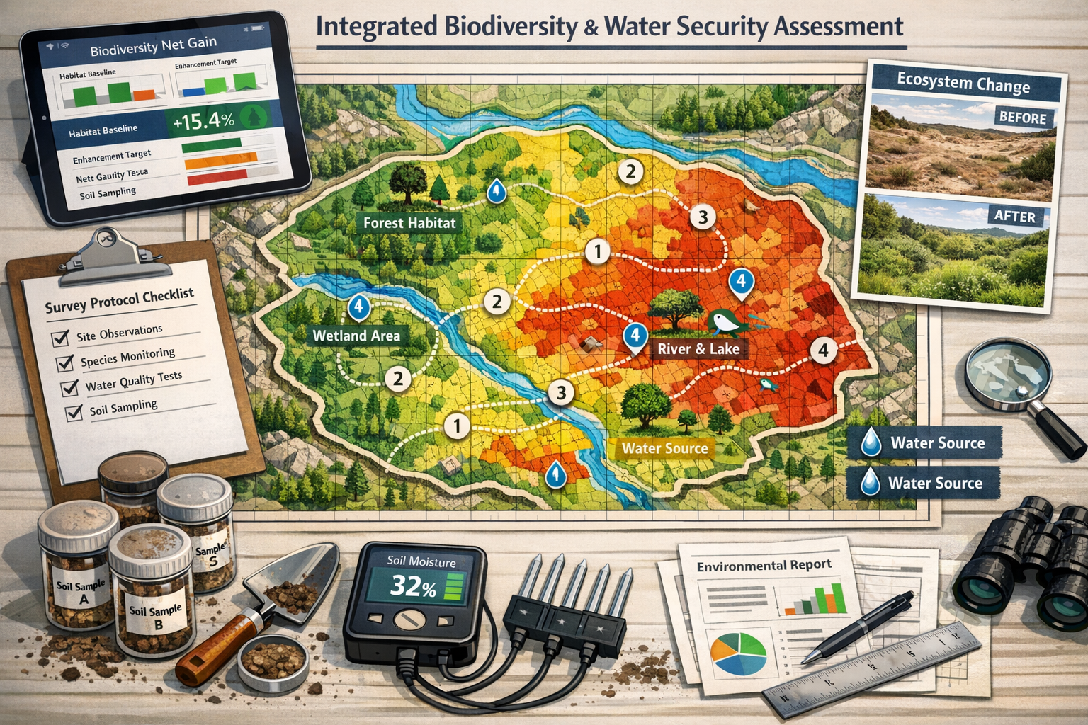
Linking Soil Moisture Data to Biodiversity Net Gain
For ecologists working on development projects, soil moisture data directly informs biodiversity net gain calculations. Habitat condition scores—a fundamental component of BNG assessments—must now reflect underlying water security.
Integration Points:
- Habitat Distinctiveness – Moisture-stressed ecosystems may warrant higher conservation priority
- Condition Assessment – Soil moisture below threshold values indicates degraded condition
- Enhancement Potential – Water security improvements can increase habitat quality scores
- Long-term Viability – Projects in declining moisture zones require additional mitigation
- Off-site Compensation – Off-site delivery options should prioritize water-secure locations
Developers and ecologists should recognize that traditional habitat assessments may significantly overestimate ecosystem health in areas experiencing the greening-drying paradox. Incorporating soil moisture protocols provides a more accurate, defensible baseline for biodiversity impact assessments.
Addressing Survey Challenges and Limitations in 2026
Technological and Methodological Constraints
Despite advances in soil moisture monitoring technology, ecologists face several practical challenges when implementing comprehensive survey protocols:
Equipment Limitations:
- 💰 Cost barriers – Professional TDR systems range from £2,000-£10,000, limiting accessibility for smaller consultancies
- 🔋 Power requirements – Continuous monitoring stations need reliable power sources in remote locations
- 🏔️ Terrain accessibility – Steep slopes, rocky soils, and dense vegetation complicate systematic sampling
- 🌧️ Weather dependencies – Extreme conditions can prevent safe field access during critical measurement periods
Methodological Challenges:
- 📏 Spatial heterogeneity – Soil moisture varies dramatically over short distances, requiring intensive sampling
- ⏱️ Temporal variability – Rapid changes after precipitation events can make timing critical
- 🔬 Calibration complexity – Different soil types require specific calibration curves for accurate readings
- 📊 Data interpretation – Distinguishing natural variability from concerning trends requires statistical expertise
Model Inadequacy and the Need for Ground-Truthing
Current hydrological and land surface models require "substantial improvement" to accurately simulate soil moisture changes [2]. These models often fail to adequately factor:
- Agricultural intensification impacts on regional water cycles
- Vegetation greening effects in semi-arid regions
- Groundwater-surface water interactions in complex hydrogeological settings
- Climate change acceleration of evaporative demand
This model inadequacy means that field-collected data is irreplaceable. Remote sensing and modeling can supplement but never substitute for direct soil moisture measurements in biodiversity surveys. Ecologists must resist pressure to rely solely on desktop assessments or modeled data when conducting rigorous environmental evaluations.
Regional Variation and Context-Specific Protocols
Soil moisture decline manifests differently across biomes and climate zones. Survey protocols must adapt to regional contexts:
Semi-Arid Grasslands:
- Focus on shallow soil layers (0-30cm) where most root activity occurs
- Increase sampling density due to high spatial variability
- Prioritize surveys during growing season moisture stress periods
Temperate Woodlands:
- Sample to greater depths (60-100cm) to capture tree root zone moisture
- Monitor seasonal recharge patterns more intensively
- Assess moisture gradients from canopy to gap positions
Wetland Transition Zones:
- Establish permanent monitoring stations for continuous data
- Document water table depth alongside soil moisture
- Track seasonal inundation patterns and duration
Agricultural Landscapes:
- Account for irrigation effects and distinguish from natural moisture
- Survey before and after cropping cycles
- Assess field margins and buffer zones separately from production areas
Quality Assurance and Peer Review
As soil moisture monitoring becomes integral to biodiversity assessments, quality assurance protocols must evolve:
Internal QA Measures:
- ✅ Equipment calibration logs maintained for all devices
- ✅ Replicate sampling at 10% of survey points by different surveyors
- ✅ Photographic documentation of all sampling locations
- ✅ Real-time data validation protocols to flag outliers
External Verification:
- 🔍 Peer review of survey methodologies before field deployment
- 🔍 Independent verification sampling at subset of locations
- 🔍 Cross-validation with remote sensing data where available
- 🔍 Statistical review of data analysis and interpretation
Organizations like Biodiversity Surveyors increasingly incorporate these quality standards into professional practice, ensuring that soil moisture data meets the same rigor as traditional biodiversity metrics.
Policy Implications and Professional Standards for 2026
Regulatory Framework Evolution
As awareness of soil moisture decline grows, regulatory frameworks are beginning to incorporate water security into environmental assessment requirements. Ecologists should anticipate:
Emerging Requirements:
- 📜 Mandatory soil moisture baselines for major development projects
- 📜 Water security impact statements alongside biodiversity assessments
- 📜 Long-term monitoring conditions attached to planning permissions
- 📜 Enhanced scrutiny of projects in identified moisture-declining regions
Planning Policy Integration:
- Local planning authorities increasingly requesting water security data
- Biodiversity net gain requirements expanding to encompass water resource impacts
- Strategic environmental assessments incorporating soil moisture projections
- Climate adaptation plans prioritizing water-secure habitats
Professional Competency and Training Needs
The integration of soil moisture monitoring into biodiversity surveys demands new professional competencies. Ecologists must develop skills in:
Technical Capabilities:
- 🎓 Soil science fundamentals and moisture dynamics
- 🎓 Equipment operation, calibration, and maintenance
- 🎓 Statistical analysis of temporal and spatial moisture data
- 🎓 Hydrological modeling and water balance calculations
Interpretive Skills:
- 🎓 Linking moisture conditions to species ecology and habitat quality
- 🎓 Distinguishing short-term variability from long-term trends
- 🎓 Assessing ecosystem resilience and vulnerability thresholds
- 🎓 Communicating water security risks to non-technical audiences
Professional bodies and training providers should prioritize developing standardized certification programs for soil moisture survey competency, similar to existing protected species survey licenses.
Collaborative Approaches and Data Sharing
The scale of soil moisture decline demands collaborative responses that transcend individual projects. Ecologists should engage in:
Data Sharing Initiatives:
- Contributing field data to regional and national monitoring networks
- Participating in collaborative research programs
- Publishing baseline data in accessible formats
- Supporting open-access data repositories
Cross-Sector Collaboration:
- Working with hydrologists, soil scientists, and climate researchers
- Engaging agricultural advisors on sustainable land management
- Partnering with water utilities on catchment-scale assessments
- Coordinating with conservation organizations on strategic priorities
These collaborative approaches enhance the value of individual surveys while building collective understanding of regional trends and effective interventions.
Practical Recommendations for Ecologists and Developers
Immediate Action Steps for 2026 Surveys
Ecologists conducting biodiversity surveys in 2026 should implement these practical measures immediately:
1. Baseline Enhancement 📊
- Add soil moisture measurements to all habitat condition assessments
- Collect minimum three-season data for meaningful baseline establishment
- Document methodology clearly for future comparison surveys
- Archive raw data with appropriate metadata
2. Equipment Investment 🔧
- Acquire at least basic TDR or FDR probe for field measurements
- Budget £3,000-£5,000 for professional-grade equipment
- Establish equipment calibration and maintenance schedules
- Train multiple team members in proper operation
3. Protocol Development 📋
- Adapt standardized protocols to regional ecosystem types
- Integrate soil moisture data collection into existing survey workflows
- Develop clear reporting templates that link moisture to biodiversity
- Establish quality assurance procedures
4. Client Communication 💬
- Educate clients on importance of water security assessment
- Explain implications for biodiversity net gain calculations
- Recommend enhanced survey scope where moisture decline evident
- Provide clear cost-benefit analysis for expanded monitoring
For Developers and Land Managers
Development projects and land management operations should proactively address soil moisture considerations:
Project Planning Phase:
- Commission soil moisture baseline surveys early in project development
- Assess water security risks alongside traditional environmental constraints
- Consider moisture trends when evaluating on-site versus off-site BNG delivery
- Budget adequately for comprehensive water-biodiversity assessments
Design Integration:
- Incorporate water-sensitive design principles into site layouts
- Prioritize retention of water-secure habitats in development footprints
- Design sustainable drainage systems that support soil moisture recharge
- Consider irrigation needs for proposed habitat creation or enhancement
Long-term Stewardship:
- Establish monitoring programs that track both biodiversity and soil moisture
- Implement adaptive management triggered by moisture decline thresholds
- Maintain flexibility to adjust habitat management in response to water stress
- Document lessons learned for future project improvement
Organizations seeking expert guidance should consider consulting with specialists like Biodiversity Surveyors who understand the integrated nature of modern ecological assessment.
Research Priorities and Knowledge Gaps
Despite growing awareness, significant knowledge gaps remain regarding soil moisture decline impacts on terrestrial ecosystems. Priority research areas include:
Ecological Thresholds:
- At what moisture levels do different habitat types experience irreversible degradation?
- Which species groups are most sensitive to moisture decline?
- How do moisture-biodiversity relationships vary across ecosystem types?
Intervention Effectiveness:
- Which habitat management techniques most effectively conserve soil moisture?
- Can targeted interventions reverse declining trends at local scales?
- What are the cost-effectiveness ratios of different water security measures?
Climate Projection Integration:
- How should ecologists incorporate future moisture projections into assessments?
- What planning horizons are appropriate for different project types?
- How can uncertainty be appropriately communicated and managed?
Ecologists conducting surveys should identify opportunities to contribute to these knowledge gaps through systematic data collection and publication of findings.
Conclusion: Adapting Ecological Practice for Water-Constrained Future
The evidence is unequivocal: soil moisture decline represents a fundamental shift in terrestrial ecosystem function that ecologists can no longer ignore. The loss of 1,614 gigatonnes of water during 2000-2002, followed by continued decline through 2021, marks a potentially permanent transformation of Earth's water cycle [1][2]. For ecologists conducting biodiversity surveys in 2026, integrating soil moisture monitoring has transitioned from optional enhancement to essential practice.
The Soil Moisture Decline in Terrestrial Ecosystems: Survey Protocols for Ecologists Tracking 2026 Water Security Impacts outlined in this article provide a foundation for this necessary evolution in professional practice. By incorporating standardized soil moisture measurements alongside traditional biodiversity metrics, ecologists can:
✅ Provide more accurate habitat condition assessments that reflect underlying water security
✅ Identify ecosystems at risk before visible vegetation stress becomes apparent
✅ Inform more resilient conservation strategies that account for changing water availability
✅ Support evidence-based planning decisions that prioritize water-secure locations
✅ Contribute to regional monitoring networks that track landscape-scale trends
The greening-drying paradox—where nearly 50% of greening areas simultaneously experience soil drying [3]—demonstrates that visual assessments alone are dangerously inadequate. Professional ecologists must embrace soil moisture monitoring as a core competency, investing in equipment, training, and protocol development.
For developers and land managers, this evolution in ecological practice offers opportunities to demonstrate environmental leadership. Projects that proactively address water security alongside biodiversity deliver more resilient outcomes and demonstrate forward-thinking stewardship. Working with qualified professionals who understand integrated water-biodiversity assessment ensures that biodiversity net gain commitments deliver genuine, long-term conservation value.
Next Steps for Ecological Professionals
Immediate Actions (Next 30 Days):
- Review current survey protocols and identify opportunities to integrate soil moisture measurements
- Research equipment options and budget for necessary investments
- Identify training opportunities in soil science and moisture monitoring techniques
- Contact professional ecological consultancies for guidance on protocol development
Medium-term Development (Next 6 Months):
- Implement pilot soil moisture monitoring on upcoming survey projects
- Develop standardized data collection and reporting templates
- Build collaborative relationships with soil scientists and hydrologists
- Contribute baseline data to regional monitoring initiatives
Long-term Integration (Next 1-2 Years):
- Establish soil moisture monitoring as standard practice across all projects
- Publish case studies and lessons learned to advance professional knowledge
- Participate in development of industry standards and best practice guidance
- Advocate for regulatory frameworks that recognize water security in environmental assessment
The terrestrial water crisis unfolding in 2026 demands that ecological professionals adapt quickly and comprehensively. Those who integrate soil moisture monitoring into biodiversity surveys position themselves at the forefront of environmental assessment practice, delivering the rigorous, forward-looking analysis that this water-constrained future requires. The protocols outlined here provide a practical starting point for this essential professional evolution.
References
[1] Rapid global soil moisture depletion confirmed – https://www.sciencedaily.com/releases/2025/05/250514155300.htm
[2] Global Soil Moisture In Permanent Decline Due To Climate Change – https://www.carbonbrief.org/global-soil-moisture-in-permanent-decline-due-to-climate-change/
[3] 2025 08 Global Greening Significant Soil Moisture – https://phys.org/news/2025-08-global-greening-significant-soil-moisture.html
[4] Terrestrial water storage decline – https://www.science.org/doi/10.1126/sciadv.adx0298
