
The ocean's hidden meadows are facing unprecedented threats. As climate change accelerates and coastal development intensifies, seagrass ecosystems—critical carbon sinks storing up to 52 tonnes of blue carbon per hectare—require sophisticated monitoring approaches that combine genetic insights with technological innovation. Building on the World Conference on Marine Biodiversity 2026 convenings [2], surveyors are now combining drones, satellites, and genetic sampling to measure seagrass status, addressing restoration challenges under ocean darkening and warming conditions.
Seagrass Genetic Diversity Integration: Remote Sensing and Field Surveys for 2026 Climate-Resilient Monitoring represents a paradigm shift in marine ecosystem assessment. This integrated approach leverages cutting-edge remote sensing technologies alongside traditional field surveys, enhanced by genetic diversity analysis, to create comprehensive monitoring frameworks that support both conservation efforts and climate resilience planning. With 72 recognized seagrass species globally [1], understanding genetic variation within and between populations has become essential for predicting ecosystem responses to environmental stressors.
Key Takeaways
- 🌊 New global standards: February 2026 established "Seagrass cover and composition" as an Essential Ocean Variable (EOV) under the Global Ocean Observing System, providing the first globally accepted observation method [1]
- 🛰️ Technology integration: Modern monitoring combines satellite imagery, drone surveys, underwater sensors, and AI-powered analysis with genetic sampling to create holistic ecosystem assessments
- 🧬 Genetic diversity matters: Understanding genetic variation across seagrass populations is crucial for predicting climate resilience and informing restoration strategies
- 📊 Tiered monitoring approach: New frameworks accommodate different resource levels, from simple presence/absence data to sophisticated genetic and spectral analysis
- 🌍 Global collaboration: The 16th International Seagrass Biology Workshop in Abu Dhabi 2026 brings together researchers to advance integrated monitoring methodologies [3]
Understanding the Essential Ocean Variable Framework for Seagrass Monitoring
The establishment of seagrass as an Essential Ocean Variable marks a transformative moment for marine conservation. In February 2026, a comprehensive specification framework published through the OBIS-GOOS collaboration officially recognized "Seagrass cover and composition" as a Biology and Ecosystems EOV [1]. This designation provides marine scientists, conservation practitioners, and policy makers with standardized protocols for measuring and reporting seagrass ecosystem health.
Three Core Measurement Subvariables
The framework proposes three fundamental metrics that form the foundation of Seagrass Genetic Diversity Integration: Remote Sensing and Field Surveys for 2026 Climate-Resilient Monitoring [1]:
- Percentage Cover: Measures the proportion of seafloor covered by seagrass within a defined area
- Species Composition: Documents the presence and relative abundance of different seagrass species
- Areal Extent: Quantifies the total area of meadows at landscape and regional scales
These subvariables work synergistically with genetic diversity data to provide a complete picture of ecosystem health. While traditional metrics assess visible structure and distribution, genetic analysis reveals hidden population dynamics, adaptive potential, and connectivity between meadows—critical information for predicting climate resilience.
Tiered Data Quality Approach
Recognizing the diverse capabilities of monitoring organizations worldwide, the EOV framework implements a pragmatic tiered approach [1]:
| Quality Tier | Requirements | Applications | Genetic Integration |
|---|---|---|---|
| High Quality | Standardized field protocols, calibrated remote sensing, species-level identification | Research, detailed restoration planning | Full genetic diversity assessment, population genomics |
| Medium Quality | Consistent methodology, validated observations, genus-level identification | Regional monitoring, trend analysis | Targeted genetic markers, key population sampling |
| Minimum Acceptable | Basic presence/absence data, location coordinates, observation date | Baseline establishment, broad-scale mapping | Opportunistic genetic sampling when possible |
This flexibility ensures that developing nations with limited scientific capacity can participate in global monitoring efforts while working toward more sophisticated assessments. The approach recognizes that even simple data—"is there seagrass in that location or not?"—contributes valuable information when collected consistently over time [1].
Compatibility with Darwin Core Standards
The monitoring guidelines were designed with data interoperability as a core principle. By aligning with Darwin Core standards, seagrass observations can be integrated into global biodiversity databases, enabling large-scale analyses and supporting initiatives like Biodiversity Net Gain that require standardized biodiversity metrics [1].
This compatibility extends to genetic data, where standardized metadata formats allow genetic diversity information to be linked with spatial observations, creating multidimensional datasets that reveal patterns invisible to single-method approaches.
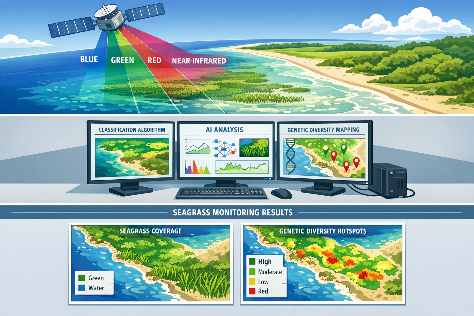
Remote Sensing Technologies Revolutionizing Seagrass Assessment
Remote sensing has transformed seagrass monitoring from labor-intensive boat-based surveys to efficient, repeatable assessments covering vast coastal areas. The integration of multiple sensor types and platforms creates comprehensive datasets that, when combined with field surveys and genetic analysis, enable unprecedented understanding of seagrass ecosystem dynamics.
Satellite-Based Multispectral and Hyperspectral Imaging
Modern satellite platforms provide regular, consistent coverage of coastal zones at resolutions suitable for seagrass mapping. Multispectral sensors capture data across discrete wavelength bands, including visible light and near-infrared, allowing algorithms to distinguish seagrass from other benthic features based on spectral signatures.
Key advantages of satellite remote sensing include:
- Large spatial coverage: Single images can capture hundreds of square kilometers
- Temporal consistency: Regular revisit schedules enable change detection and phenology studies
- Historical archives: Decades of satellite data allow retrospective analysis of seagrass trends
- Cost efficiency: Per-hectare monitoring costs are dramatically lower than field surveys alone
Advanced hyperspectral sensors capture data across hundreds of narrow wavelength bands, providing detailed spectral information that can differentiate seagrass species and detect physiological stress before visible symptoms appear. This capability is particularly valuable when integrated with genetic diversity data, as areas with low genetic diversity may show distinct spectral signatures indicating reduced stress tolerance.
Drone-Based High-Resolution Surveys
Unmanned aerial vehicles (UAVs or drones) bridge the gap between satellite observations and field surveys, providing ultra-high-resolution imagery (centimeter-scale) that captures fine-scale patterns in seagrass distribution and health. Abu Dhabi's advanced monitoring program demonstrates the power of this technology, testing up-to-date sensors and integrating artificial intelligence validated by long-standing field observations [4].
Drone surveys excel at:
- Mapping complex meadow boundaries and fragmentation patterns
- Documenting seasonal changes in seagrass density and extent
- Identifying optimal sampling locations for genetic diversity assessment
- Providing visual context for interpreting satellite data
When flight paths are designed to systematically cover genetic sampling sites, drone imagery creates a bridge between molecular data and landscape-scale patterns, revealing how genetic structure relates to environmental gradients and disturbance history.
Underwater Acoustic and Optical Sensors
Beneath the water surface, acoustic technologies like side-scan sonar and multibeam echosounders map seagrass in turbid waters where optical methods fail. These sensors detect differences in seafloor texture and height, distinguishing dense seagrass meadows from bare sediment or macroalgae.
Underwater cameras and hyperspectral sensors deployed from boats or autonomous underwater vehicles (AUVs) capture detailed imagery and spectral data in clear waters. These tools are essential for:
- Validating remote sensing classifications
- Assessing seagrass canopy structure and shoot density
- Documenting species composition in mixed meadows
- Guiding precise genetic sampling locations
The integration of acoustic mapping with genetic surveys is particularly powerful for understanding how topographic complexity and sediment characteristics influence genetic connectivity between meadows.
Artificial Intelligence and Machine Learning Integration
The volume of data generated by modern remote sensing platforms requires automated analysis pipelines. Machine learning algorithms, particularly deep learning approaches using convolutional neural networks, can classify seagrass with accuracy approaching expert human interpreters while processing data thousands of times faster [2].
AI systems trained on datasets that include genetic diversity information can potentially predict genetic patterns from spectral signatures, enabling genetic diversity estimation across entire landscapes based on limited field sampling. This emerging capability could revolutionize conservation planning by identifying genetically diverse hotspots requiring protection and genetically depauperate areas needing restoration intervention.
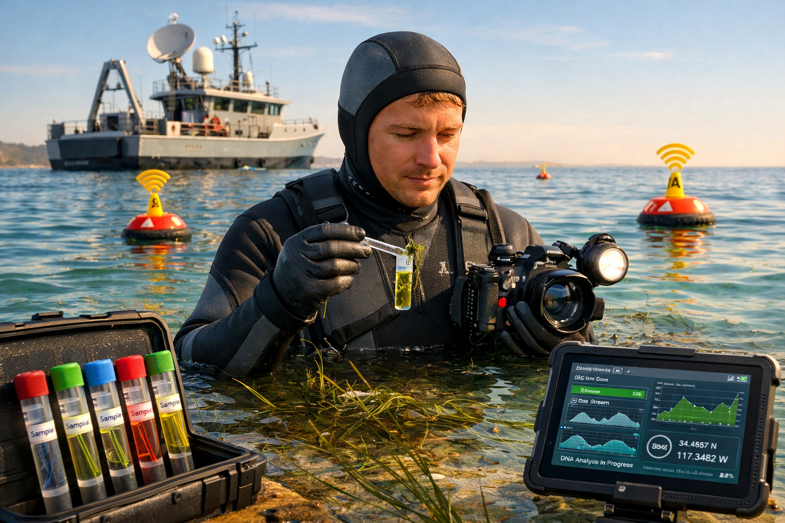
Field Survey Methods and Genetic Sampling Integration
While remote sensing provides the spatial scope, field surveys deliver the ground-truth data and biological samples essential for comprehensive ecosystem assessment. Seagrass Genetic Diversity Integration: Remote Sensing and Field Surveys for 2026 Climate-Resilient Monitoring depends on carefully designed field protocols that efficiently collect both ecological and genetic information.
Stratified Sampling Design
Effective integration begins with strategic sampling design that maximizes information gain while minimizing resource expenditure. Stratified random sampling, guided by remote sensing data, ensures that field effort captures the full range of environmental conditions and seagrass characteristics present across a study area.
Key considerations include:
- Environmental gradients: Sample across depth, sediment type, wave exposure, and salinity ranges
- Meadow characteristics: Include varying densities, species compositions, and disturbance histories
- Spatial distribution: Balance clustered sampling for genetic connectivity analysis with dispersed sampling for landscape representation
- Temporal variation: Coordinate sampling timing with phenological stages and seasonal conditions
By overlaying genetic sampling locations with remote sensing imagery, researchers can test hypotheses about how environmental factors visible in spectral data relate to genetic structure, creating predictive models applicable to unsampled areas.
Standardized Ecological Measurements
The EOV framework specifies core measurements that should accompany genetic sampling [1]:
Quadrat-based assessments provide quantitative data on:
- Percentage cover (visual estimation or point-intercept method)
- Shoot density (counts per square meter)
- Species identification and relative abundance
- Canopy height and biomass
Transect surveys capture spatial patterns:
- Meadow boundary delineation
- Patchiness and fragmentation metrics
- Species zonation patterns
- Association with other benthic organisms
These ecological data contextualize genetic findings, revealing whether genetic differentiation corresponds to ecological differences or reflects historical isolation despite current environmental similarity.
Genetic Sampling Protocols
Modern genetic analysis requires surprisingly small tissue samples—a few leaf blades or root fragments per individual plant. Non-destructive sampling techniques preserve meadow integrity while collecting sufficient material for multiple genetic analyses.
Standard genetic sampling protocols include:
- Individual selection: Collect from 20-30 individuals per site, spaced at least 5 meters apart to avoid sampling clones
- Tissue preservation: Immediately place samples in silica gel or preservation buffer to maintain DNA quality
- Metadata recording: Document precise GPS coordinates, depth, substrate type, and associated species
- Photographic documentation: Capture images of sampling locations for integration with remote sensing data
Genetic markers commonly used in seagrass studies include:
- Microsatellites (SSRs): Highly variable markers excellent for population structure and clonality assessment
- Single nucleotide polymorphisms (SNPs): Genome-wide markers providing detailed information on adaptive variation
- Chloroplast sequences: Maternally inherited markers revealing historical dispersal patterns
- Transcriptomics: Gene expression analysis identifying stress responses and adaptive capacity
The choice of markers depends on research questions and available resources, with SNP-based approaches becoming increasingly cost-effective and informative for climate resilience assessment.
Laboratory Analysis and Data Integration
Genetic samples undergo DNA extraction, marker amplification or sequencing, and statistical analysis to quantify diversity metrics:
- Allelic richness: Number of genetic variants present
- Heterozygosity: Proportion of individuals carrying different alleles
- Genetic differentiation: Variation among populations
- Effective population size: Number of breeding individuals
- Clonal diversity: Extent of asexual versus sexual reproduction
These metrics are then spatially referenced and analyzed alongside remote sensing classifications and ecological measurements. Geographic Information Systems (GIS) platforms integrate these diverse data types, enabling visualization of genetic diversity patterns in relation to environmental variables and disturbance history.
Advanced analyses can identify:
- Genetically distinct populations requiring separate management
- Connectivity corridors facilitating gene flow
- Source populations with high genetic diversity for restoration material
- Vulnerable populations with low diversity requiring intervention
This integrated understanding supports initiatives like achieving biodiversity net gain, where quantifying and enhancing genetic diversity contributes to overall ecosystem health metrics.
Climate Resilience Assessment Through Integrated Monitoring
The ultimate goal of Seagrass Genetic Diversity Integration: Remote Sensing and Field Surveys for 2026 Climate-Resilient Monitoring is predicting and enhancing ecosystem resilience to climate change. Seagrass meadows face multiple climate-related stressors, including ocean warming, acidification, sea-level rise, and increased storm intensity. Genetic diversity provides the raw material for adaptation, making its assessment critical for long-term conservation planning.
Identifying Climate-Resilient Genotypes
Integrated monitoring can identify genotypes and populations demonstrating resilience to specific stressors. By comparing genetic profiles of seagrass in areas experiencing different environmental conditions—revealed through remote sensing time series—researchers can pinpoint genetic variants associated with stress tolerance.
For example, meadows persisting in areas where remote sensing detects frequent thermal stress events may harbor heat-tolerant genotypes. Similarly, populations maintaining high productivity (detectable through spectral indices) despite acidification may possess genetic adaptations valuable for future conditions.
Abu Dhabi's extensive seagrass coverage, spanning over 3,000 square kilometers and representing more than 98 percent of the United Arab Emirates' total seagrass area [3], provides an ideal natural laboratory for such studies. The region's three main habitat-forming species distributed across various sediment types, tidal zones, and depth gradients [4] offer opportunities to study genetic adaptation across environmental gradients.
Predicting Ecosystem Responses to Future Conditions
Predictive modeling integrates genetic, ecological, and environmental data to forecast seagrass responses to climate scenarios. Machine learning algorithms trained on historical data—linking genetic diversity metrics with ecosystem changes detected through remote sensing—can project future trajectories under different warming and sea-level rise scenarios.
Key modeling approaches include:
- Species distribution models incorporating genetic diversity as a predictor variable
- Population viability analysis using genetic data to estimate extinction risk
- Connectivity modeling predicting gene flow under changing ocean currents and sea levels
- Adaptive capacity assessment quantifying evolutionary potential based on genetic variation
These models inform biodiversity impact assessments for coastal development projects, ensuring that projects avoid or mitigate impacts to genetically critical populations.
Informing Restoration and Conservation Strategies
Integrated monitoring directly supports evidence-based conservation decisions:
Restoration source selection: Genetic data identifies diverse source populations providing seeds or transplants with broad adaptive potential. Remote sensing efficiently maps the extent and health of potential source meadows, while field surveys confirm species composition and ecological suitability.
Genetic rescue interventions: Populations identified as genetically depauperate through molecular analysis and showing decline in remote sensing time series may benefit from introducing genetic material from diverse populations to enhance adaptive capacity.
Protected area design: Spatial analysis of genetic diversity patterns guides marine protected area placement to capture genetic hotspots and maintain connectivity corridors. This approach aligns with broader biodiversity net gain strategies that prioritize both species and genetic diversity.
Monitoring program optimization: Integrated data reveals which sites provide maximum information for detecting ecosystem changes, allowing monitoring resources to be allocated efficiently.
Blue Carbon and Climate Mitigation
Seagrass meadows are recognized as critical blue carbon ecosystems, storing carbon in both biomass and sediments. Abu Dhabi's seagrass beds demonstrate this capacity, storing up to 52 tonnes of blue carbon per hectare [3], making them valuable nature-based solutions for climate change mitigation.
Integrated monitoring enhances blue carbon assessment by:
- Accurately mapping seagrass extent and density through remote sensing
- Quantifying carbon storage rates through field measurements
- Identifying genetically diverse populations likely to maintain carbon storage under future conditions
- Detecting early warning signs of meadow decline that could release stored carbon
This information supports carbon credit programs and climate-related policy frameworks that recognize seagrass conservation as a climate mitigation strategy.
Global Collaboration and the 2026 International Seagrass Biology Workshop
The 16th International Seagrass Biology Workshop, hosted by Abu Dhabi in 2026, represents a milestone in global seagrass research collaboration [3]. For the first time held in the Middle East, this gathering brings together scientists, managers, and policy makers to share advances in integrated monitoring methodologies and coordinate global observation networks.
Regional Leadership and Knowledge Exchange
Abu Dhabi's selection as host reflects the region's growing leadership in coastal and marine research. The Environment Agency Abu Dhabi's commitment to the Seagrass Breakthrough 2030—a global initiative to protect and restore seagrass ecosystems—demonstrates how regional action contributes to global conservation goals [3].
The workshop facilitates:
- Methodology standardization: Researchers align field protocols and remote sensing approaches to ensure data compatibility across regions
- Technology transfer: Developed nations share advanced monitoring technologies with emerging programs
- Comparative studies: Researchers from the 72 recognized seagrass species' ranges [1] share insights on species-specific monitoring challenges
- Capacity building: Training programs enhance technical skills in integrated monitoring approaches
Addressing Ocean Darkening Challenges
A critical theme emerging from 2026 convenings is ocean darkening—the reduction in light penetration caused by increased phytoplankton blooms, suspended sediments, and dissolved organic matter. This phenomenon, exacerbated by nutrient pollution and climate change, threatens seagrass meadows dependent on light for photosynthesis [2].
Integrated monitoring is essential for detecting and responding to ocean darkening:
- Remote sensing can track water clarity changes through spectral analysis
- Field surveys document seagrass depth limits and productivity changes
- Genetic analysis identifies populations with adaptations to low-light conditions
By combining these approaches, researchers can predict which meadows are most vulnerable to darkening and prioritize interventions like nutrient pollution reduction or restoration with low-light-tolerant genotypes.
Building Baseline Data and Trend Analysis
The World Conference on Marine Biodiversity 2026 emphasizes that effective conservation depends on establishing robust baselines and detecting trends [2]. Seagrass Genetic Diversity Integration: Remote Sensing and Field Surveys for 2026 Climate-Resilient Monitoring provides the framework for this essential work.
Coordinated global monitoring enables:
- Baseline establishment: Documenting current seagrass extent, composition, and genetic diversity before further degradation
- Trend detection: Regular repeated surveys reveal whether conservation interventions are succeeding
- Early warning systems: Integrated data identifies declining meadows before complete loss occurs
- Success metrics: Quantifiable indicators track progress toward global conservation targets
This systematic approach supports biodiversity planning at multiple scales, from local restoration projects to international policy commitments.
Practical Implementation for Conservation Practitioners
For organizations implementing seagrass monitoring programs, the integrated approach offers clear advantages but requires careful planning and resource allocation.
Starting Points for Different Capacity Levels
Limited resources: Begin with the minimum acceptable data tier [1]—establishing presence/absence records with accurate coordinates and dates. Use freely available satellite imagery (Landsat, Sentinel) and simple classification methods. Collect opportunistic genetic samples when field access occurs for other purposes.
Moderate resources: Implement medium-quality monitoring with consistent field protocols, validated remote sensing classifications, and targeted genetic sampling at key sites. Partner with academic institutions for genetic analysis. Utilize drone surveys for priority areas.
Substantial resources: Deploy comprehensive high-quality monitoring integrating calibrated sensors, standardized field protocols, and systematic genetic sampling. Invest in AI-powered analysis pipelines and predictive modeling. Contribute data to global databases and participate in international research networks.
Essential Equipment and Partnerships
Remote sensing: Access to satellite imagery (often freely available), drone platform with RGB and multispectral cameras, image processing software (open-source options available).
Field surveys: Underwater cameras, GPS units, quadrats and transect tapes, waterproof data recording systems, small boats or kayaks for site access.
Genetic sampling: Silica gel or preservation buffer, sample bags with labels, coolers for transport, established relationships with genetics laboratories.
Partnerships: Collaboration with universities provides access to genetic analysis facilities and expertise. Engagement with global monitoring networks ensures data compatibility and access to best practices. Coordination with biodiversity surveyors integrates seagrass monitoring into broader ecosystem assessments.
Data Management and Sharing
Effective integrated monitoring requires robust data management systems that:
- Store diverse data types (spatial, genetic, ecological, environmental) in compatible formats
- Maintain metadata documenting collection methods and quality control
- Enable spatial analysis and visualization through GIS platforms
- Facilitate data sharing with global repositories while respecting data ownership
Contributing data to international databases like OBIS (Ocean Biodiversity Information System) maximizes the value of monitoring investments by enabling large-scale analyses and supporting global conservation initiatives.
Regulatory and Policy Applications
Integrated monitoring data directly supports regulatory compliance and policy development:
- Environmental impact assessments: Baseline data on seagrass extent and genetic diversity informs development project reviews
- Marine spatial planning: Spatial distribution of genetically important populations guides zoning decisions
- Restoration requirements: Genetic diversity metrics establish targets for restoration projects
- Climate adaptation planning: Resilience assessments identify priority areas for protection under climate change scenarios
Understanding these applications helps secure funding and institutional support for monitoring programs, as decision-makers recognize the practical value of integrated data for achieving biodiversity objectives.
Conclusion
Seagrass Genetic Diversity Integration: Remote Sensing and Field Surveys for 2026 Climate-Resilient Monitoring represents the cutting edge of marine ecosystem assessment. By combining the spatial scope of satellite and drone observations with the biological insights from field surveys and genetic analysis, this integrated approach provides unprecedented understanding of seagrass ecosystem health, resilience, and conservation needs.
The establishment of seagrass as an Essential Ocean Variable in 2026 [1], coupled with global collaboration through forums like the International Seagrass Biology Workshop [3] and World Conference on Marine Biodiversity [2], creates momentum for standardized, coordinated monitoring that can track progress toward conservation goals and inform evidence-based management decisions.
As climate change intensifies pressures on coastal ecosystems, the ability to identify resilient populations, predict future changes, and design effective interventions becomes increasingly critical. Genetic diversity—the foundation of adaptive capacity—must be integrated into monitoring frameworks alongside traditional ecological metrics to ensure seagrass meadows persist as vital blue carbon sinks, biodiversity hotspots, and coastal protection systems.
Actionable Next Steps
For conservation organizations:
- Assess current monitoring capacity and identify opportunities to integrate genetic sampling into existing field programs
- Establish partnerships with genetics laboratories and remote sensing specialists
- Contribute data to global databases to maximize conservation impact
- Engage with biodiversity net gain frameworks that recognize genetic diversity
For researchers:
- Develop standardized protocols linking genetic markers with spectral signatures
- Advance AI-powered analysis tools that integrate diverse data types
- Conduct comparative studies across seagrass species and regions
- Publish findings in open-access formats to accelerate knowledge transfer
For policy makers:
- Incorporate genetic diversity metrics into marine conservation regulations
- Fund integrated monitoring programs that provide actionable data for decision-making
- Support international collaboration and data sharing initiatives
- Recognize seagrass conservation in climate mitigation strategies
For coastal managers:
- Use integrated monitoring data to prioritize restoration sites and source populations
- Implement early warning systems based on remote sensing change detection
- Design marine protected areas that maintain genetic connectivity
- Monitor intervention effectiveness through repeated integrated assessments
The tools, frameworks, and collaborative networks are now in place to transform seagrass conservation. Success requires commitment to integrated approaches that recognize the inseparable connections between genetic diversity, ecosystem function, and climate resilience. The actions taken in 2026 will determine whether these critical ecosystems persist to provide their invaluable services for generations to come.
References
[1] Guidelines For Seagrass Measuring And Reporting – https://obis.org/2026/02/27/guidelines-for-seagrass-measuring-and-reporting/
[2] 2 Marine Biodiversity Its All About Baselines And Trends – https://www.wcmb2026.org/2-marine-biodiversity-its-all-about-baselines-and-trends
[3] International Seagrass Biology – https://www.ead.gov.ae/en/Media-Centre/News/International-Seagrass-Biology
[4] Environment Agency Abu Dhabi Wins Bid To Host 16th International Seagrass Biology Workshop In 2026 – https://www.mediaoffice.abudhabi/en/environment/environment-agency-abu-dhabi-wins-bid-to-host-16th-international-seagrass-biology-workshop-in-2026/
