
The world's oceans just entered a new era of protection. With the High Seas Treaty entering into force on January 17, 2026, marine conservationists and biodiversity surveyors face an unprecedented challenge: how do we scale up our survey methods from small research sites to vast ocean landscapes covering millions of square kilometers? The answer lies in developing robust protocols for scaling biodiversity surveys from sites to landscapes: protocols for net gain in high seas contexts that meet the treaty's ambitious conservation requirements[1][7].
This transformation isn't just about collecting more data—it's about fundamentally rethinking how we assess, monitor, and protect marine biodiversity in areas beyond national jurisdiction. As the treaty now covers approximately 60% of the ocean and nearly half of the planet's surface[6][7], surveyors must integrate cutting-edge remote sensing technologies with traditional field methods to create comprehensive landscape-level assessments that support effective ocean management.
Key Takeaways
- 🌊 The High Seas Treaty requires landscape-scale biodiversity assessments across 60% of global ocean areas, demanding new survey protocols that integrate site-based and remote sensing data
- 📊 Multi-scale integration is essential—combining local field surveys with satellite imagery, acoustic monitoring, and environmental DNA sampling creates comprehensive ocean biodiversity maps
- 🎯 Net gain frameworks must now extend to high seas contexts, requiring baseline assessments, impact predictions, and monitoring protocols adapted for vast marine landscapes
- 🔬 Standardized protocols ensure data comparability across international waters, supporting the treaty's requirements for environmental impact assessments and Marine Protected Area establishment
- ⚙️ Adaptive management approaches allow surveyors to refine methods based on ongoing monitoring, ensuring biodiversity net gain outcomes remain achievable in dynamic ocean environments
Understanding the High Seas Treaty and Its Biodiversity Requirements
The Biodiversity Beyond National Jurisdiction (BBNJ) Agreement represents the first legally binding global framework to protect ocean biodiversity beyond national waters[3][4]. After achieving 81 ratifications by January 16, 2026, including the European Union and 16 Member States[5], this groundbreaking treaty establishes clear requirements for how we assess and protect marine life in international waters.
What the Treaty Demands from Biodiversity Surveyors
The treaty introduces several critical requirements that directly impact how biodiversity surveys must be conducted:
Environmental Impact Assessments (EIAs) are now mandatory for major ocean activities such as deep sea mining[8]. These assessments require comprehensive baseline data that extends far beyond traditional project sites to encompass regional ecosystem functions and connectivity.
Marine Protected Areas (MPAs) can now be established in high seas regions for the first time under a comprehensive global framework[4][9]. Designating these protected zones requires landscape-scale biodiversity data that identifies critical habitats, migration corridors, and ecosystem hotspots across vast ocean areas.
Monitoring and compliance mechanisms demand ongoing surveillance of biodiversity outcomes, making it essential to develop scalable survey protocols that can track changes over time and across enormous spatial scales.
Understanding biodiversity net gain principles becomes crucial in this context, as the high seas framework adapts terrestrial conservation concepts to marine environments.
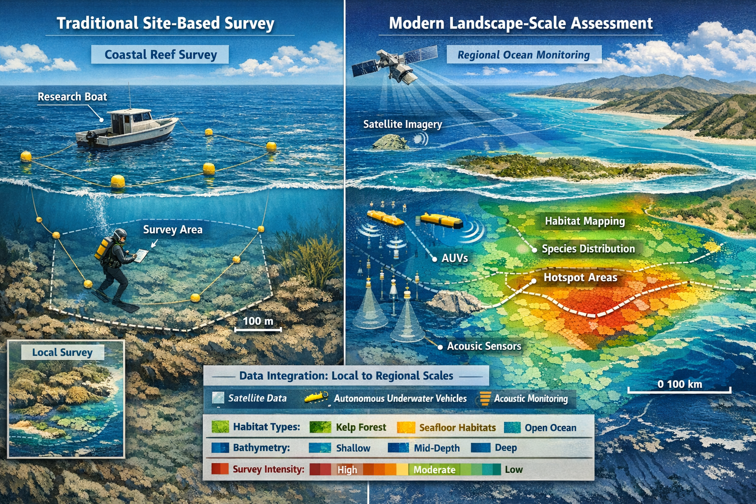
The Scale Challenge: From Sites to Seascapes
Traditional marine biodiversity surveys typically focus on specific sites—perhaps a few square kilometers around a proposed development or research station. However, the high seas context demands a fundamentally different approach:
| Traditional Site Surveys | Landscape-Scale High Seas Surveys |
|---|---|
| 1-10 km² coverage | 10,000-100,000+ km² coverage |
| Single habitat type | Multiple interconnected ecosystems |
| Days to weeks duration | Months to years monitoring |
| Direct observation primary | Remote sensing + field validation |
| Local species inventories | Regional biodiversity patterns |
This scaling challenge requires surveyors to develop protocols for net gain in high seas contexts that maintain scientific rigor while covering unprecedented spatial extents.
Core Protocols for Scaling Biodiversity Surveys from Sites to Landscapes
Developing effective protocols for scaling biodiversity surveys from sites to landscapes requires a systematic approach that integrates multiple data sources and survey methods. The following framework provides a structured pathway for surveyors working in high seas contexts.
Step 1: Establish Multi-Scale Survey Design
The foundation of landscape-scale surveys begins with a hierarchical sampling design that captures biodiversity patterns at multiple spatial scales:
Macro-scale (Regional Level): Define the overall study area based on biogeographic regions, ocean currents, and management boundaries. This typically encompasses 50,000-500,000 km² in high seas contexts.
Meso-scale (Seascape Level): Identify distinct habitat zones within the region using bathymetric data, oceanographic features, and preliminary remote sensing. These zones typically range from 1,000-10,000 km².
Micro-scale (Site Level): Select representative sites within each habitat zone for intensive field surveys. These sites serve as ground-truthing locations and typically cover 1-100 km².
This nested design ensures that site-level data can be statistically extrapolated to landscape scales while maintaining scientific validity—a critical requirement for biodiversity net gain assessments.
Step 2: Integrate Remote Sensing Technologies
Remote sensing forms the backbone of landscape-scale ocean surveys, providing continuous coverage that field methods alone cannot achieve:
🛰️ Satellite Remote Sensing captures surface ocean characteristics including:
- Chlorophyll concentrations (primary productivity proxy)
- Sea surface temperature patterns
- Ocean color variations indicating phytoplankton communities
- Surface current dynamics
- Floating marine debris and pollution
🔊 Acoustic Monitoring uses passive and active sonar systems to:
- Map seafloor bathymetry and habitat structure
- Detect marine mammal vocalizations across vast areas
- Identify fish aggregations and biomass estimates
- Monitor shipping traffic and anthropogenic noise
🤖 Autonomous Underwater Vehicles (AUVs) and gliders provide:
- Water column profiling over extended transects
- High-resolution seafloor imaging
- Environmental DNA (eDNA) sample collection
- Continuous multi-month deployments
The key to successful scaling lies in calibrating remote sensing data with field observations from representative sites, creating predictive models that translate satellite signals into biodiversity metrics.
Step 3: Conduct Strategic Field Surveys
While remote sensing provides broad coverage, targeted field surveys remain essential for validating landscape-scale predictions and capturing biodiversity details:
Stratified Random Sampling: Select field survey sites using stratified random sampling within each habitat zone identified through remote sensing. This ensures representative coverage while remaining logistically feasible.
Multi-Method Approaches: Deploy complementary survey techniques at each site:
- Visual surveys using ROVs (remotely operated vehicles) or manned submersibles
- eDNA sampling to detect species presence without direct observation
- Benthic sampling using grabs, cores, or trawls for invertebrate communities
- Pelagic sampling with nets, traps, or baited cameras for fish and mobile fauna
- Acoustic recording for marine mammal and fish vocalization documentation
Temporal Replication: Conduct surveys across multiple seasons and years to capture temporal variability—essential for distinguishing natural fluctuations from anthropogenic impacts.
Understanding how to conduct biodiversity impact assessments provides valuable context for structuring these field components.
Step 4: Apply Statistical Scaling Models
The critical step in scaling biodiversity surveys from sites to landscapes involves developing robust statistical models that extrapolate site-level observations to regional scales:
Species Distribution Models (SDMs): Use environmental predictors (temperature, depth, productivity) to model species occurrence probability across the entire landscape based on presence records from survey sites.
Habitat Suitability Models: Map habitat types across the landscape using remote sensing data calibrated with field observations, then assign biodiversity values to each habitat class.
Spatial Interpolation: Apply geostatistical methods (kriging, spatial autocorrelation models) to estimate biodiversity metrics between survey sites based on spatial patterns.
Ensemble Modeling: Combine multiple modeling approaches to generate consensus predictions with associated uncertainty estimates—critical for management decisions.
These models transform scattered site observations into continuous landscape-level biodiversity maps that support net gain calculations and MPA designation under the High Seas Treaty framework.
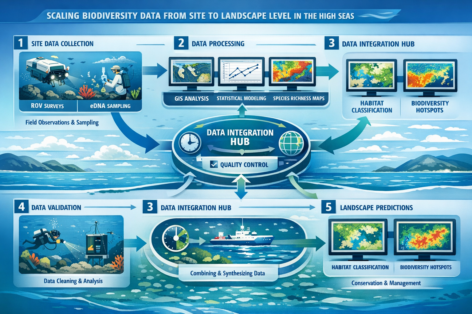
Step 5: Implement Quality Control and Validation
Maintaining data quality across landscape scales requires rigorous quality control protocols:
✅ Standardized Methods: Use internationally recognized survey protocols (e.g., IUCN standards, OBIS data formats) to ensure comparability across regions and time periods.
✅ Inter-calibration: Conduct joint surveys with multiple teams to assess observer variability and instrument consistency.
✅ Independent Validation: Reserve 20-30% of field sites for model validation rather than model building, providing unbiased accuracy assessments.
✅ Uncertainty Quantification: Explicitly document and map uncertainty in landscape-scale predictions, identifying areas requiring additional survey effort.
✅ Peer Review: Submit protocols and results to scientific peer review before using them for management decisions.
Implementing Net Gain Frameworks in High Seas Contexts
Translating terrestrial biodiversity net gain concepts to high seas contexts presents unique challenges, but the fundamental principles remain applicable when adapted to marine landscapes.
Establishing Baseline Conditions
Net gain requires robust baseline assessments that document pre-impact biodiversity conditions across the landscape. In high seas contexts, this involves:
Temporal Baselines: Conduct multi-year surveys to establish natural variability ranges. Ocean ecosystems exhibit high temporal variability, so single-year snapshots prove insufficient for detecting impacts.
Spatial Baselines: Map biodiversity across the entire potential impact zone plus appropriate reference areas. For activities like deep sea mining, this may encompass 100,000+ km² to capture indirect effects through sediment plumes and noise propagation.
Functional Baselines: Document ecosystem functions (productivity, nutrient cycling, carbon sequestration) alongside species inventories, as net gain should encompass functional as well as compositional biodiversity.
The biodiversity net gain report requirements provide useful frameworks that can be adapted to marine contexts.
Calculating Biodiversity Metrics
High seas net gain assessments require metrics that capture biodiversity value across landscape scales:
Species Richness: Total number of species across habitat types, weighted by rarity and conservation status.
Habitat Extent and Quality: Area of each habitat type multiplied by condition scores based on structural complexity, pollution levels, and disturbance history.
Connectivity: Measures of landscape connectivity including corridor functionality and genetic exchange between populations.
Ecosystem Services: Quantification of services like carbon storage, nursery habitat provision, and food web support.
These metrics should be combined into composite biodiversity units analogous to terrestrial systems, allowing net gain calculations that balance losses in one area against gains elsewhere.
Designing Compensation and Enhancement Measures
When impacts cannot be fully avoided or mitigated, compensation measures must deliver net gain at landscape scales:
Spatial Planning: Identify compensation sites with high restoration potential or conservation value, ensuring ecological equivalence to impact areas.
Temporal Considerations: Account for time lags between impact and compensation benefits, applying discounting factors for delayed gains.
Additionality: Ensure compensation delivers biodiversity benefits beyond what would occur without intervention, avoiding "paper gains" from protecting areas already secure.
Long-term Security: Establish governance mechanisms ensuring compensation areas remain protected for periods matching impact duration—potentially decades for mining operations.
Exploring off-site versus on-site delivery options helps inform compensation strategy development.
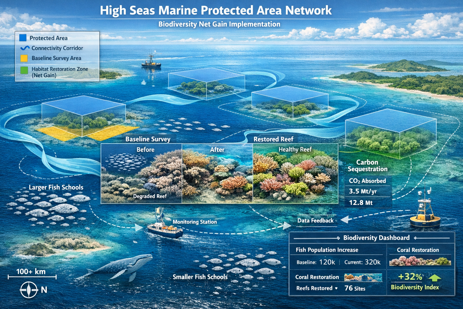
Monitoring and Adaptive Management
Protocols for net gain in high seas contexts must include ongoing monitoring that verifies predicted outcomes and enables adaptive management:
Monitoring Frequency: Conduct landscape-scale surveys at intervals appropriate to ecosystem dynamics—typically annually for pelagic systems, every 2-3 years for benthic communities.
Trigger Thresholds: Establish biodiversity thresholds that trigger management responses when monitoring detects unexpected declines.
Adaptive Protocols: Develop decision frameworks that specify how management actions will be modified based on monitoring results.
Reporting Requirements: Provide regular public reports on net gain outcomes, supporting treaty compliance verification and stakeholder engagement.
The upcoming third preparatory meeting scheduled for March 23 to April 2, 2026[10], will likely establish specific operational guidelines for these monitoring requirements.
Practical Implementation: Tools and Technologies
Successfully implementing scaling biodiversity surveys from sites to landscapes: protocols for net gain in high seas contexts requires access to appropriate tools and technologies.
Essential Technology Suite
Data Collection Platforms:
- Satellite remote sensing services (ESA Copernicus, NASA Ocean Color)
- Autonomous underwater vehicles (AUVs) and gliders
- Moored acoustic monitoring arrays
- eDNA sampling and analysis systems
- ROV and submersible platforms for visual surveys
Data Management Systems:
- Geographic Information Systems (GIS) for spatial analysis
- Biodiversity databases (OBIS, GBIF) for data sharing
- Cloud computing platforms for processing large datasets
- Version control systems for protocol documentation
Analytical Software:
- Species distribution modeling packages (MaxEnt, biomod2)
- Spatial statistics tools (R spatial packages, ArcGIS)
- Machine learning platforms for image analysis
- Visualization software for stakeholder communication
Capacity Building and Training
Implementing these protocols requires trained personnel with interdisciplinary skills:
🎓 Technical Training: Survey teams need expertise in marine biology, oceanography, remote sensing, spatial statistics, and data management.
🤝 International Collaboration: High seas surveys often require multi-national partnerships, demanding cultural competency and collaborative skills.
📋 Standardization Workshops: Regular training ensures consistent application of protocols across regions and institutions.
💼 Professional Development: Ongoing education keeps practitioners current with evolving technologies and methodologies.
Organizations like Biodiversity Surveyors provide specialized expertise in developing and implementing these advanced survey protocols.
Challenges and Solutions in High Seas Biodiversity Scaling
Despite robust protocols, scaling biodiversity surveys to high seas landscapes presents persistent challenges that require innovative solutions.
Logistical and Financial Constraints
Challenge: High seas surveys require expensive vessels, equipment, and personnel over extended periods, with costs potentially exceeding millions of dollars per expedition.
Solutions:
- Shared Infrastructure: Develop international consortia that share vessel time and equipment costs
- Autonomous Systems: Increase reliance on low-cost autonomous platforms that reduce vessel requirements
- Phased Approaches: Implement surveys in stages, prioritizing high-value or high-risk areas
- Leveraged Funding: Combine research, monitoring, and compliance surveys to maximize efficiency
Data Gaps and Uncertainty
Challenge: Even with landscape-scale protocols, vast ocean areas remain poorly surveyed, creating uncertainty in biodiversity predictions.
Solutions:
- Explicit Uncertainty Mapping: Quantify and communicate uncertainty spatially, identifying priority areas for additional survey effort
- Precautionary Approaches: Apply conservative assumptions in data-poor areas, erring toward protection
- Adaptive Monitoring: Focus initial monitoring on validating predictions in uncertain areas, refining models iteratively
- Citizen Science: Engage fishing vessels, shipping companies, and recreational users in opportunistic data collection
Taxonomic Expertise Limitations
Challenge: Identifying deep-sea and pelagic species requires specialized taxonomic expertise that remains scarce globally.
Solutions:
- eDNA Metabarcoding: Use genetic approaches that reduce reliance on morphological identification
- Image Recognition AI: Develop machine learning systems that automate species identification from visual surveys
- Taxonomic Networks: Establish international expert networks providing remote identification support
- Morphospecies Approaches: Use operational taxonomic units when species-level identification proves infeasible
Temporal Variability
Challenge: Ocean ecosystems exhibit high natural variability, making it difficult to distinguish impacts from natural fluctuations.
Challenge: Ocean ecosystems exhibit high natural variability, making it difficult to distinguish impacts from natural fluctuations.
Solutions:
- Long-term Baseline Studies: Invest in multi-year pre-impact monitoring to characterize natural variability ranges
- Reference Area Comparisons: Use control sites to distinguish local impacts from regional environmental changes
- Statistical Power Analysis: Design monitoring programs with sufficient replication to detect meaningful changes
- Oceanographic Context: Incorporate environmental covariates (temperature, currents, productivity) into analyses to account for natural drivers
Understanding how to achieve biodiversity net gain targets provides frameworks applicable to managing these challenges.
Regulatory Compliance and Stakeholder Engagement
Implementing protocols for net gain in high seas contexts requires navigating complex regulatory landscapes and engaging diverse stakeholders.
Meeting Treaty Requirements
The High Seas Treaty establishes specific expectations for biodiversity assessments:
Environmental Impact Assessment Standards: Activities requiring EIAs must demonstrate that assessments cover appropriate spatial scales, incorporate cumulative effects, and consider transboundary impacts[8].
Scientific Committee Review: Assessment protocols and results undergo review by the treaty's scientific and technical body, requiring transparent documentation and peer-reviewed methodologies.
Public Access: Biodiversity data and assessment results must be made publicly available through appropriate databases and repositories.
Precautionary Principle: When scientific uncertainty exists, decisions must favor conservation, placing burden of proof on activity proponents.
Surveyors should familiarize themselves with biodiversity net gain planning requirements as useful analogues for high seas compliance.
Stakeholder Coordination
Successful landscape-scale surveys require coordination among multiple stakeholder groups:
National Governments: Coastal states with interests in adjacent high seas areas, flag states of vessels conducting activities, and treaty parties with conservation mandates.
Industry Sectors: Fishing operations, shipping companies, deep sea mining proponents, offshore energy developers, and biotechnology firms all require engagement.
Conservation Organizations: NGOs, research institutions, and Indigenous groups contribute expertise, funding, and advocacy supporting robust assessment protocols.
International Bodies: Regional fisheries management organizations, the International Seabed Authority, and other existing governance bodies require coordination to avoid conflicting requirements.
Local Communities: While high seas lie beyond national jurisdiction, activities there affect coastal communities dependent on migratory species and ocean health.
Effective engagement requires transparent communication of survey methods, findings, and uncertainty, along with meaningful opportunities for stakeholder input into protocol development and adaptive management decisions.
Future Directions and Emerging Technologies
As scaling biodiversity surveys from sites to landscapes matures in high seas contexts, several emerging technologies and approaches promise to enhance survey capabilities.
Artificial Intelligence and Machine Learning
AI systems increasingly automate biodiversity data collection and analysis:
- Automated Image Analysis: Deep learning algorithms identify and count species from ROV footage and camera trap images with accuracy approaching human experts
- Acoustic Classification: AI classifies marine mammal calls and fish sounds from continuous acoustic recordings, processing years of data in hours
- Predictive Modeling: Machine learning improves species distribution models by detecting complex nonlinear relationships between species and environmental variables
- Anomaly Detection: AI identifies unusual patterns in monitoring data that may indicate ecosystem changes requiring investigation
Environmental DNA Innovations
eDNA technology continues advancing, offering powerful tools for landscape-scale surveys:
- Water Column Profiling: Continuous eDNA sampling along vessel transects creates biodiversity maps spanning thousands of kilometers
- Quantitative eDNA: Improved methods translate eDNA concentrations into biomass estimates, not just presence/absence
- Ancient DNA: Sediment core eDNA reveals historical biodiversity baselines predating human impacts
- Real-time Analysis: Portable sequencing devices enable shipboard eDNA analysis, allowing adaptive survey design during expeditions
Satellite Technology Advances
Next-generation satellite systems enhance remote sensing capabilities:
- Hyperspectral Imaging: Sensors detecting hundreds of wavelength bands improve habitat classification and phytoplankton community identification
- Synthetic Aperture Radar: All-weather imaging penetrates clouds and darkness, providing consistent coverage
- Increased Resolution: Commercial satellites now achieve sub-meter resolution, enabling detection of individual large organisms
- Satellite Constellations: Networks of small satellites provide daily revisit times, capturing temporal dynamics
Integrated Ocean Observing Systems
Coordinated observing networks create persistent monitoring infrastructure:
- Global Mooring Arrays: Permanent monitoring stations provide continuous time-series data across ocean basins
- Tagged Animal Networks: Thousands of tagged fish, mammals, and turtles serve as mobile sensor platforms collecting environmental and biological data
- Citizen Science Platforms: Smartphone apps and online portals engage global communities in biodiversity observation and reporting
- Data Integration Platforms: Centralized systems aggregate data from diverse sources, enabling synthetic landscape-scale analyses
These technologies will progressively reduce the cost and increase the accuracy of protocols for net gain in high seas contexts, making comprehensive biodiversity assessment increasingly feasible.
Conclusion
The entry into force of the High Seas Treaty in 2026 marks a transformative moment for ocean conservation, creating both obligations and opportunities for biodiversity surveyors. Scaling biodiversity surveys from sites to landscapes: protocols for net gain in high seas contexts represents not just a technical challenge but a fundamental shift in how humanity approaches stewardship of the global ocean commons.
The protocols outlined in this article—integrating multi-scale survey design, remote sensing technologies, strategic field validation, statistical modeling, and rigorous quality control—provide a roadmap for meeting treaty requirements while advancing marine conservation science. By establishing baseline conditions, calculating biodiversity metrics, designing effective compensation measures, and implementing adaptive monitoring, surveyors can ensure that activities in international waters achieve genuine biodiversity net gain rather than merely minimizing harm.
Actionable Next Steps
For organizations and professionals working to implement these protocols:
-
Invest in Capacity Building: Develop interdisciplinary teams with expertise spanning marine biology, remote sensing, spatial statistics, and data management. Consider partnerships with specialized firms like Biodiversity Surveyors that offer expertise in scaling assessment methodologies.
-
Establish Baseline Programs: Begin multi-year baseline surveys now in areas where future activities are anticipated, recognizing that robust baselines require years of data collection to characterize natural variability.
-
Adopt Standardized Protocols: Implement internationally recognized survey methods and data standards to ensure results contribute to global biodiversity knowledge and meet treaty compliance requirements.
-
Embrace Technological Innovation: Incorporate emerging technologies like eDNA, autonomous vehicles, and AI-powered analysis into survey programs, recognizing that these tools dramatically improve the feasibility of landscape-scale assessments.
-
Foster International Collaboration: Develop partnerships across national boundaries, sectors, and disciplines, recognizing that high seas biodiversity assessment requires coordinated global effort.
-
Engage Stakeholders Early: Involve governments, industry, conservation organizations, and affected communities in protocol development and implementation, building trust and shared ownership of outcomes.
-
Plan for Adaptive Management: Design monitoring programs that generate actionable information supporting iterative improvement of conservation measures based on observed outcomes.
The ocean's vastness once made comprehensive biodiversity assessment seem impossible. Today, through innovative protocols that scale from sites to landscapes, surveyors can provide the knowledge foundation needed to protect marine life across 60% of our planet's surface. As the High Seas Treaty moves from legal framework to operational reality, the biodiversity surveying community stands at the forefront of one of conservation's greatest challenges—and greatest opportunities.
The protocols exist. The technologies are available. The legal framework is in place. Now comes the essential work of implementation, ensuring that biodiversity net gain becomes not just a policy aspiration but a measurable reality across the high seas that belong to all humanity.
References
[1] Treaty Negotiations – https://highseasalliance.org/treaty-negotiations/
[2] Charting New Waters High Seas Treaty After Two Months – https://www.eli.org/vibrant-environment-blog/charting-new-waters-high-seas-treaty-after-two-months
[3] Inside The New High Seas Treaty – https://www.earthday.org/inside-the-new-high-seas-treaty/
[4] High Seas Agreement Enters Into Force A Turning Point For Species Conservation Beyond National Borders – https://www.iucnsos.org/high-seas-agreement-enters-into-force-a-turning-point-for-species-conservation-beyond-national-borders/
[5] Navigating The New Un High Seas Treaty Key Compliance Risks For Life Sciences Companies – https://www.insideeulifesciences.com/2026/03/03/navigating-the-new-un-high-seas-treaty-key-compliance-risks-for-life-sciences-companies/
[6] Operationalizing High Seas Agreement Ongoing Developments And – https://www.iddri.org/en/publications-and-events/blog-post/operationalizing-high-seas-agreement-ongoing-developments-and
[7] High Seas Treaty Enters Force Milestone Ocean Conservation 2026 01 16 En – https://oceans-and-fisheries.ec.europa.eu/news/high-seas-treaty-enters-force-milestone-ocean-conservation-2026-01-16_en
[8] A New Treaty Comes Into Force To Govern Life On The High Seas – https://news.mongabay.com/2026/01/a-new-treaty-comes-into-force-to-govern-life-on-the-high-seas/
[9] High Seas Treaty What It Means Divers – https://www.scubadiving.com/conservation/high-seas-treaty-what-it-means-divers
[10] High Seas Treaty Bbnj 2026 – https://globalclimaterisks.org/insights/blog/high-seas-treaty-bbnj-2026/
