
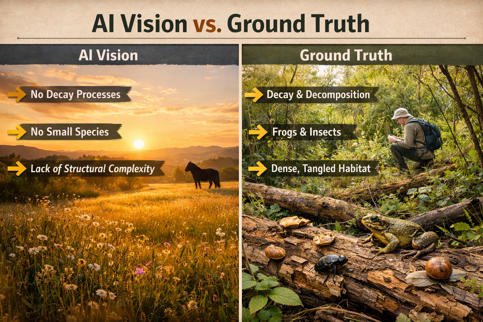
When University of Aberdeen researchers analyzed AI-generated rewilding landscapes in early 2026, they discovered a troubling pattern: every major chatbot produced nearly identical sanitized visions featuring distant hills, golden meadows, streams, and photogenic ponies—while systematically omitting decay, invertebrates, amphibians, and the messy ecological processes that define genuine ecosystem recovery[1][2]. This revelation exposes a critical gap between artificial intelligence predictions and the complex reality that biodiversity professionals encounter in the field, raising urgent questions about how we validate restoration claims and achieve credible Biodiversity Net Gain outcomes.
Rewilding Reality Check: Ground-Truthing AI Models with Field Biodiversity Surveys for Authentic Ecosystem Recovery has become essential as developers, planners, and conservation organizations increasingly rely on AI tools to predict ecological outcomes. Without rigorous field validation protocols, these digital predictions risk creating compliance frameworks built on incomplete ecological understanding.
Key Takeaways
- 🤖 AI models consistently generate sanitized rewilding visions that exclude crucial ecological elements like decay, disturbance, invertebrates, and amphibians
- 🔍 Field biodiversity surveys remain irreplaceable for validating AI predictions and capturing the full complexity of ecosystem recovery
- ✅ Hybrid protocols combining AI efficiency with human expertise provide the most credible pathway for authentic net gain verification
- 📊 Ground-truthing methodologies coupling remote sensing with in-situ surveys are essential for reversing AI biases
- 🌱 Credible restoration claims require documentation of complete ecological processes, not just photogenic flagship species
The AI Bias Problem: Why Machine Learning Models Miss Ecological Complexity
The research published by University of Aberdeen geographers in April 2026 represents one of the first systematic analyses of generative AI visual materials through social science methods[2]. When researchers prompted Gemini, ChatGPT, and other widely-used chatbots to generate rewilding imagery, the results revealed striking homogeneity.
What AI Gets Wrong About Ecosystem Recovery
AI-generated landscapes consistently featured:
- Distant hills and open meadows with golden lighting
- Iconic mammals like ponies, deer, and horses
- Pristine water features without algae or disturbance
- Aerial perspectives from inaccessible vantage points
- Absence of human presence or built structures
What these sanitized visions systematically excluded:
- ❌ Decay and decomposition processes
- ❌ Disturbance and succession stages
- ❌ Death and predation
- ❌ Reptiles and amphibians
- ❌ Invertebrates (insects, spiders, soil fauna)
- ❌ Human infrastructure and management
- ❌ Seasonal variation and harsh weather
This gap matters profoundly for achieving Biodiversity Net Gain without the risk of overstating ecological recovery. When AI models learn from biased training data—predominantly social media posts and advocacy websites featuring drone footage with "lovable" animals[1]—they perpetuate incomplete representations that obscure the full spectrum of biodiversity.
The Training Data Problem
The sanitized imagery stems directly from AI models drawing inspiration from organizational visual content that prioritizes:
- Public engagement over scientific accuracy
- Charismatic megafauna over functional diversity
- Aesthetic appeal over ecological realism
- Simplified narratives over complex processes
Researchers emphasize this trend remains reversible through deliberate incorporation of diverse species, human presence, and complete ecological processes into visual training datasets[2].
Ground-Truthing Protocols: Validating AI Predictions with Field Biodiversity Surveys
Rewilding Reality Check: Ground-Truthing AI Models with Field Biodiversity Surveys for Authentic Ecosystem Recovery requires systematic validation methodologies that couple remote sensing capabilities with boots-on-the-ground verification.
Essential Components of Hybrid Validation Frameworks
1. Multi-Taxa Field Inventories
Comprehensive biodiversity assessments must document:
| Taxonomic Group | Survey Methods | AI Limitations |
|---|---|---|
| Vascular Plants | Quadrat sampling, transects | Cannot detect early succession species |
| Invertebrates | Pitfall traps, sweep nets, soil cores | Rarely included in training data |
| Amphibians & Reptiles | Visual encounter surveys, refugia checks | Systematically excluded from AI imagery |
| Birds | Point counts, territory mapping | AI focuses on iconic species only |
| Mammals | Camera traps, sign surveys | Biased toward charismatic species |
| Fungi & Lichens | Substrate examination | Completely absent from AI models |
Professional biodiversity surveyors bring taxonomic expertise that remains essential for species identification and ecological interpretation.
2. Vegetation Delineation with In-Situ Verification
Ground-truthing approaches coupling vegetation delineation of aerial images with field surveys are being used successfully to validate landscape classifications[7]. This methodology:
- Maps habitat types using drone or satellite imagery
- Validates classifications through on-site vegetation surveys
- Corrects misidentifications where spectral signatures overlap
- Documents structural complexity invisible to remote sensors
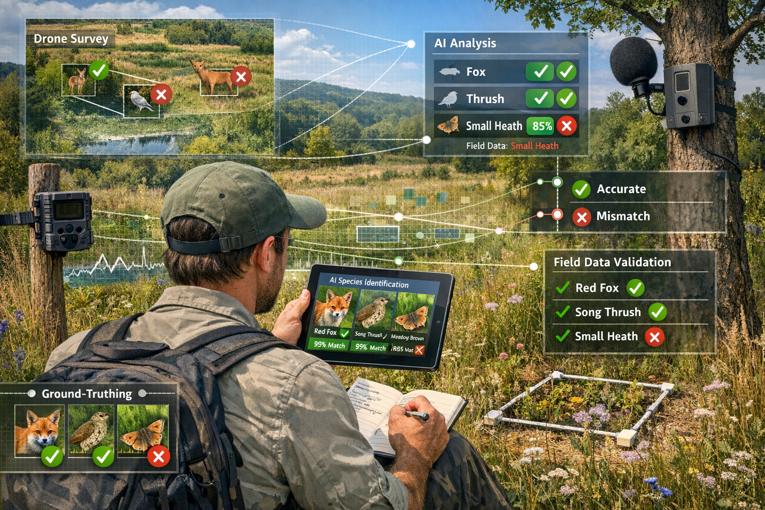
3. Keeping Humans in the Loop
Ecologist Carly Batist emphasizes that while AI automates species identification from camera trap images and vocalizations, "you really want to keep a human in the loop" with trained specialists needed to identify species and calls to properly train models[3]. This principle extends across all validation protocols.
Human expertise remains irreplaceable for:
- Distinguishing similar species with subtle differences
- Identifying rare or unexpected species
- Interpreting ecological context and habitat quality
- Recognizing signs of disturbance or stress
- Validating AI confidence scores
- Detecting model failures and edge cases
Practical Implementation for Developers and Planners
Organizations seeking credible Biodiversity Net Gain outcomes should implement staged validation protocols:
Phase 1: Baseline Assessment
- Conduct comprehensive field surveys before AI modeling
- Document complete species inventories across all taxa
- Establish reference conditions for restoration targets
- Capture seasonal variation through repeat surveys
Phase 2: AI Model Training
- Use verified field data to train site-specific models
- Include diverse species and ecological processes
- Incorporate images of decay, disturbance, and succession
- Validate model outputs against held-back field data
Phase 3: Ongoing Monitoring
- Deploy AI tools for efficient broad-scale monitoring
- Schedule regular field verification surveys
- Flag discrepancies between predictions and observations
- Iteratively improve model accuracy with new field data
This hybrid approach leverages AI efficiency while maintaining scientific rigor through professional biodiversity assessment.
Building Credible Net Gain Claims Through Authentic Ecosystem Recovery Documentation
Rewilding Reality Check: Ground-Truthing AI Models with Field Biodiversity Surveys for Authentic Ecosystem Recovery ultimately serves a critical regulatory and ethical purpose: ensuring that biodiversity compensation claims reflect genuine ecological improvement rather than algorithmic optimism.

The Credibility Gap in Current Practice
As of 2026, the biodiversity data landscape has shifted toward supply chain and financial risk assessment priorities[4]. While datasets like the Cecil-PlanetSapling Major Mines dataset and agricultural risk mapping serve important functions, they often prioritize business intelligence over ecological authenticity.
This creates risks for developers and landowners who may:
- Overestimate recovery timelines based on AI projections
- Undercount functional diversity by focusing on visible species
- Miss critical habitat quality indicators invisible to remote sensing
- Face compliance challenges when actual outcomes diverge from predictions
Documentation Standards for Authentic Recovery
Credible ecosystem recovery documentation requires evidence of:
Structural Complexity ✅
- Multiple vegetation layers (canopy, understory, ground cover)
- Deadwood in various decay stages
- Varied topography and microhabitats
- Natural disturbance patterns
Functional Diversity ✅
- Complete trophic networks (producers, consumers, decomposers)
- Pollinator populations and plant-pollinator interactions
- Nutrient cycling indicators (soil fauna, fungi)
- Predator-prey relationships
Process Indicators ✅
- Natural regeneration and recruitment
- Succession dynamics across site gradients
- Seasonal phenological patterns
- Evidence of resilience to disturbance
Taxonomic Breadth ✅
- Representation across all major groups
- Presence of specialist and indicator species
- Age structure within populations
- Genetic diversity where assessable
These standards align with how to achieve 10% Biodiversity Net Gain requirements while ensuring ecological authenticity.
Reversing AI Biases Through Better Training Data
The University of Aberdeen researchers emphasize that incomplete AI representations can still be reversed by incorporating diverse species, human presence, and the full spectrum of ecological processes into organizational visual content[2]. This requires:
Content Strategy Shifts:
- Publish ground-level photography alongside aerial shots
- Feature invertebrates, amphibians, and "uncharismatic" species
- Document decay, disturbance, and seasonal variation
- Show human stewardship and management activities
- Highlight ecological complexity over aesthetic simplicity
Model Training Improvements:
- Curate training datasets with verified field observations
- Balance charismatic species with functional diversity
- Include images across seasons and weather conditions
- Incorporate expert annotations on ecological processes
- Validate outputs against comprehensive field surveys
Emerging Tools and Accessibility
Partnerships like iNaturalist's Google AI Accelerator and Global Nature Watch are lowering barriers to using spatial data for biodiversity monitoring, making tools more accessible to diverse users[4]. These developments support hybrid validation approaches by:
- 🌍 Democratizing species identification through citizen science
- 📱 Enabling rapid field data collection via mobile applications
- 🔗 Integrating observations with professional survey databases
- 📊 Providing real-time validation of AI predictions
However, professional expertise remains essential for conducting biodiversity impact assessments that meet regulatory standards and ecological rigor.
Regulatory Implications for 2026 and Beyond
As AI tools become more prevalent in environmental assessment, regulatory frameworks must evolve to ensure:
- Mandatory field verification of AI-generated predictions
- Standardized ground-truthing protocols for net gain claims
- Transparency requirements for model training data and accuracy
- Professional certification for biodiversity AI applications
- Periodic model audits against long-term monitoring data
Organizations planning off-site or on-site delivery of biodiversity net gain must anticipate these evolving standards.
Case Study: Knepp Estate and Cairngorm Connect
The University of Aberdeen research specifically compared AI outputs with visual materials from UK rewilding advocates including Cairngorm Connect and Knepp Estate Rewilding[1][2]. These organizations demonstrate best practices by:
- Publishing diverse imagery showing ecological complexity
- Documenting long-term monitoring data with field surveys
- Featuring less charismatic species alongside iconic mammals
- Showing human involvement in landscape management
- Communicating realistic timelines for ecosystem recovery
Their visual content provides valuable training data for improving AI model accuracy when incorporated into machine learning datasets.
Conclusion: Integrating AI Efficiency with Field Validation for Credible Ecosystem Recovery
The revelation that AI models systematically sanitize rewilding landscapes—excluding decay, invertebrates, and ecological complexity—serves as a wake-up call for the biodiversity sector in 2026. Rewilding Reality Check: Ground-Truthing AI Models with Field Biodiversity Surveys for Authentic Ecosystem Recovery is not merely an academic exercise; it represents an essential quality control mechanism for ensuring that restoration claims reflect genuine ecological improvement.
The path forward requires hybrid protocols that leverage AI's efficiency for broad-scale monitoring while maintaining rigorous field validation through professional biodiversity surveys. Developers, planners, and conservation organizations must resist the temptation to rely solely on algorithmic predictions, instead investing in comprehensive ground-truthing that documents complete taxonomic diversity, structural complexity, and functional ecological processes.
Actionable Next Steps
For Developers and Planners:
- Commission baseline field surveys before deploying AI monitoring tools
- Require validation protocols in biodiversity net gain assessments
- Budget for ongoing field verification throughout project timelines
- Engage certified biodiversity professionals for quality assurance
For Conservation Organizations:
- Diversify visual content to include ecological complexity
- Document and publish complete species inventories
- Show decay, disturbance, and "uncharismatic" biodiversity
- Contribute verified field data to improve AI training datasets
For AI Developers:
- Incorporate expert-validated field observations in training data
- Build transparency features showing model confidence and limitations
- Design human-in-the-loop workflows for critical identifications
- Establish accuracy benchmarks against long-term monitoring data
For Regulatory Bodies:
- Develop standardized ground-truthing protocols for net gain claims
- Require disclosure of AI model accuracy and validation methods
- Mandate professional field verification for compliance assessments
- Create certification programs for biodiversity AI applications
The future of authentic ecosystem recovery depends on recognizing both the power and limitations of artificial intelligence. By grounding AI predictions in rigorous field biodiversity surveys, the sector can build credible restoration frameworks that serve both ecological integrity and regulatory compliance. The messy reality of genuine rewilding—complete with decay, invertebrates, and ecological complexity—deserves accurate representation in both our digital models and our landscape outcomes.
For organizations ready to implement credible validation frameworks, professional biodiversity surveyors provide the expertise necessary to bridge the gap between AI predictions and field reality, ensuring that ecosystem recovery claims reflect authentic ecological improvement.
References
[1] 2026 03 Ai Rewilding Messy Reality – https://phys.org/news/2026-03-ai-rewilding-messy-reality.html
[2] abdn.ac.uk – https://www.abdn.ac.uk/news/25360/
[3] Watch – https://www.youtube.com/watch?v=RMywCLgKKc8
[4] On Our Radar New Biodiversity And Nature Data Products In Early 2026 – https://www.naturetechcollective.org/stories/on-our-radar-new-biodiversity-and-nature-data-products-in-early-2026
[7] egu26.eu – https://www.egu26.eu/session/56740
