
The transformation of agricultural landscapes into thriving ecosystems is no longer a distant vision—it's happening now across farms worldwide. As soil health declines and pollinator populations dwindle, farmers and ecologists are joining forces to implement Regenerative Agriculture Corridors: Biodiversity Survey Protocols for Diverse Crop Rotations in 2026 that restore natural systems while maintaining productive farmland. These corridors, woven through diverse crop rotations and agroforestry systems, are becoming essential pathways for wildlife, pollinators, and soil organisms that underpin agricultural resilience.
The year 2026 marks a pivotal moment for regenerative agriculture. With the USDA's Regenerative Pilot Program allocating $700 million in conservation funding[1] and Bolivia launching its first agricultural mitigation program[5], governments worldwide are recognizing that biodiversity surveys are no longer optional—they're essential for qualifying for nature finance and demonstrating measurable environmental impact. Ecologists now use standardized protocols to verify pollinator networks, document soil biodiversity recovery, and quantify the ecological benefits that make regenerative farms eligible for conservation payments and biodiversity credits.
Key Takeaways
- Survey protocols for regenerative corridors combine traditional ecological monitoring with modern technology to document biodiversity gains across diverse crop rotations and wildlife pathways
- Diverse crop rotations integrated with wildlife corridors create measurable improvements in pollinator abundance, soil organism diversity, and ecosystem connectivity that qualify farms for conservation funding
- The 2026 USDA Regenerative Pilot Program has reallocated $700 million toward practices that require biodiversity verification, making standardized survey protocols essential for accessing financial incentives[1]
- Nature finance opportunities increasingly depend on documented biodiversity outcomes, with survey data serving as the foundation for biodiversity credits and conservation payments
- Agroforestry and corridor systems in Latin America have already transformed over 42,000 hectares while achieving 45% of five-year impact targets, demonstrating scalable success[2]
Understanding Regenerative Agriculture Corridors in 2026
What Are Regenerative Agriculture Corridors?
Regenerative agriculture corridors represent intentionally designed habitat pathways that connect fragmented ecosystems across working agricultural landscapes. Unlike conventional field margins, these corridors integrate native vegetation, diverse plantings, and strategic wildlife pathways directly into farm management systems. They serve multiple functions simultaneously: providing migration routes for wildlife, supporting pollinator populations, enhancing soil biodiversity, and creating buffer zones that protect water quality.
Wildlife corridors are highly compatible with regenerative agriculture practices such as agroforestry and can be expanded through economic incentives, collaborative action, and legal protection[3]. These corridors range dramatically in scale—from hedgerows connecting field sections to landscape-level networks spanning hundreds of miles. The Florida panther, for example, requires corridors extending up to 200 miles, while the globe skimmer dragonfly migrates across the Indian Ocean using natural pathways[3].
In 2026, more stakeholders across farming, food, and policy are engaging with regeneration as a framework for rebuilding agricultural systems rather than merely as a practice[6]. This shift recognizes that isolated regenerative fields cannot achieve their full ecological potential without connectivity to broader landscapes.
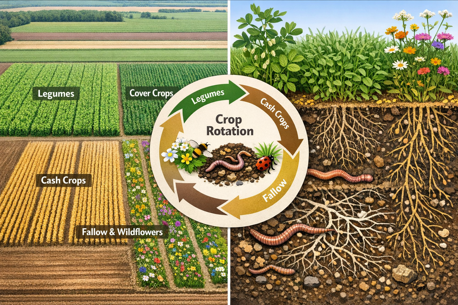
The Role of Diverse Crop Rotations
Diverse crop rotations form the agricultural foundation that makes corridors effective. By rotating legumes, cover crops, cash crops, and fallow periods, farmers create temporal and spatial diversity that supports different species throughout the year. This diversity attracts beneficial insects during flowering periods, provides habitat for ground-dwelling organisms during cover crop phases, and maintains year-round food sources for wildlife using the corridors.
The Nature Conservancy's Regenerative Ranching and Agriculture (R2A) strategy has achieved remarkable results through this integrated approach. In Colombia, the GCS regenerative project has transformed more than 42,000 hectares of land into diverse forest-pasture systems, applying regenerative ranching and agroecology principles[2]. These systems demonstrate that productivity and biodiversity can increase simultaneously when rotations are properly designed.
Key benefits of diverse rotations within corridor systems include:
- Enhanced soil biodiversity through varied root structures and organic matter inputs
- Pollinator support across multiple flowering periods and plant species
- Pest regulation by maintaining beneficial insect populations
- Carbon sequestration through continuous living root systems
- Nutrient cycling that reduces synthetic fertilizer dependency
Policy and Funding Landscape
The policy environment in 2026 has created unprecedented opportunities for farmers implementing biodiversity-focused regenerative practices. The USDA launched the Regenerative Pilot Program in December 2025 with a January 15, 2026 national batching deadline and $700 million in reallocated EQIP and CSP funds, representing the administration's core conservation initiative[1]. While this initial deadline has passed, the program signals a fundamental shift in how conservation funding prioritizes biodiversity outcomes.
The NRCS programs accepting applications under regenerative frameworks include the Environmental Quality Incentives Program (EQIP), Conservation Stewardship Program (CSP), Agricultural Conservation Easement Program (ACEP), and the new Regenerative Pilot Program[1]. Each program now emphasizes measurable biodiversity improvements, making survey protocols essential for application success.
Internationally, Bolivia launched its first regenerative programme for agricultural and livestock mitigation in March 2026, beginning work on previously absent mitigation strategies for this sector[5]. This global momentum creates opportunities for farmers who can document their biodiversity contributions through rigorous survey methods, potentially accessing biodiversity credits and conservation payments.
Biodiversity Survey Protocols for Regenerative Agriculture Corridors: Biodiversity Survey Protocols for Diverse Crop Rotations in 2026
Establishing Baseline Assessments
Before implementing regenerative corridors, establishing comprehensive baseline assessments is critical for measuring future progress and qualifying for conservation programs. These assessments document the starting conditions of soil biodiversity, pollinator populations, vegetation communities, and wildlife presence across the agricultural landscape.
Professional baseline assessments typically include:
- Soil biodiversity sampling – Collecting soil cores to analyze microbial communities, earthworm populations, and mycorrhizal fungi networks
- Vegetation surveys – Documenting existing plant species, coverage percentages, and native vs. non-native ratios
- Pollinator inventories – Conducting timed observations to record bee, butterfly, and other pollinator species and abundance
- Wildlife monitoring – Installing camera traps and conducting transect surveys to document mammal, bird, and reptile presence
- Water quality testing – Establishing nutrient runoff and sediment baselines in adjacent waterways
The biodiversity impact assessment process used in development contexts provides a useful framework for agricultural applications. These assessments create the documentation necessary for demonstrating improvement over time and accessing funding that requires measurable outcomes.
Standardized Survey Methods for Crop Rotation Systems
Implementing standardized survey methods ensures that biodiversity data collected across different farms and seasons can be compared and aggregated. In 2026, several protocols have emerged as industry standards for regenerative agriculture corridors.
Pollinator Surveys: The most widely adopted approach involves timed transect walks during peak flowering periods. Surveyors walk predetermined routes through corridors and adjacent crop areas, recording all pollinator observations within a two-meter band for 30-minute periods. This method, repeated monthly during the growing season, provides comparable data on pollinator abundance and diversity. Species identification can be enhanced using photo documentation and DNA barcoding for difficult-to-identify specimens.
Soil Organism Monitoring: Soil biodiversity assessment combines field sampling with laboratory analysis. Standard protocols involve collecting soil cores at fixed depths (0-15cm and 15-30cm) from multiple locations within each crop rotation zone and corridor. These samples undergo analysis for:
- Microbial biomass and community composition
- Earthworm counts and species identification
- Nematode populations and functional groups
- Mycorrhizal colonization rates
- Soil enzyme activity
Vegetation Community Analysis: Quadrat sampling along corridors documents plant species richness and coverage. Surveyors place one-meter square frames at regular intervals, identifying and estimating coverage percentages for all plant species present. This method tracks the establishment of native species, monitors invasive plant pressure, and documents flowering resource availability.
Wildlife Connectivity Assessment: Camera traps positioned at strategic corridor locations provide non-invasive wildlife monitoring. Modern motion-activated cameras with infrared capabilities document species using corridors day and night. Supplementary methods include track plates, hair snares, and acoustic monitoring for birds and bats.
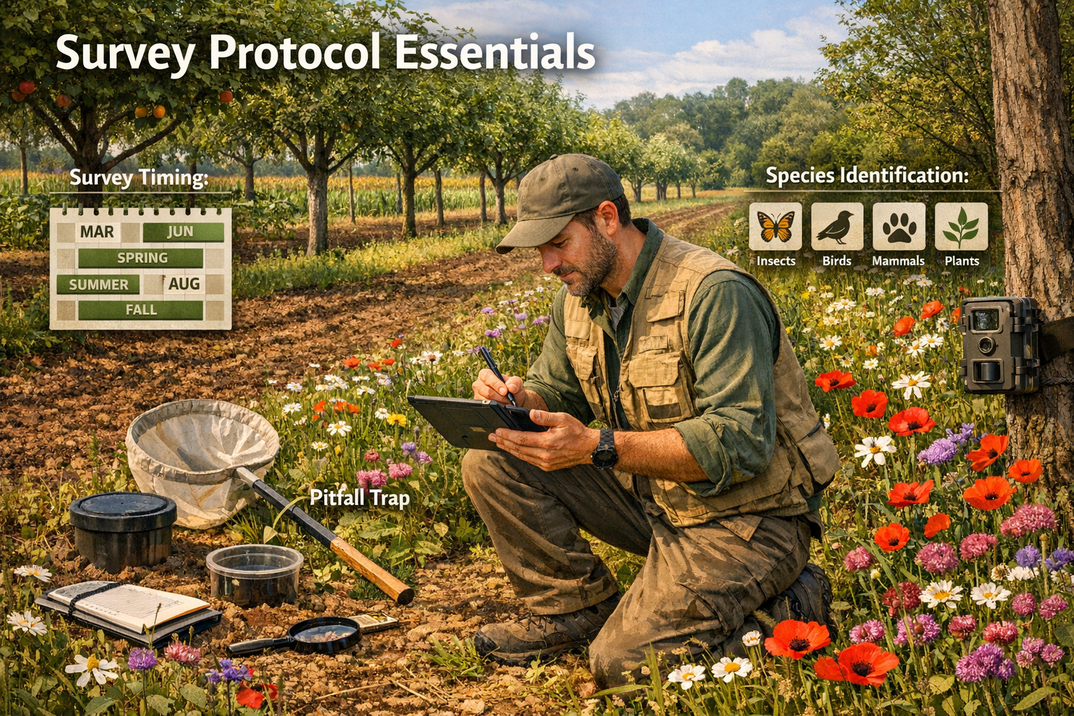
Seasonal Monitoring Schedules
Seasonal variation profoundly affects biodiversity in agricultural systems, making properly timed surveys essential for comprehensive assessment. The following schedule represents best practices for regenerative agriculture corridors in temperate regions:
| Season | Survey Focus | Frequency | Key Indicators |
|---|---|---|---|
| Spring | Early pollinators, ground-nesting birds, soil emergence | Bi-weekly | Native bee emergence, wildflower establishment, soil temperature |
| Summer | Peak pollinator diversity, crop-corridor interactions | Monthly | Pollinator abundance, beneficial insect populations, corridor utilization |
| Fall | Late-season pollinators, wildlife preparation, soil health | Monthly | Monarch butterfly migration, seed production, organic matter incorporation |
| Winter | Overwintering habitat, soil structure, wildlife corridors | Quarterly | Snow tracking, cavity use, soil aggregate stability |
This schedule ensures that biodiversity contributions are captured across all crop rotation phases. Cover crops planted in fall, for example, provide critical overwintering habitat that wouldn't be documented in summer-only surveys. Similarly, early spring surveys capture ground-nesting bees that emerge before many crop flowering periods.
Technology Integration and Data Management
Modern biodiversity surveys increasingly incorporate technology solutions that improve accuracy, reduce costs, and enable real-time data sharing with conservation programs. In 2026, several technological approaches have become standard practice:
🔬 DNA Metabarcoding: Soil samples can now be analyzed using environmental DNA techniques that identify hundreds of species from a single sample, dramatically reducing identification costs and time.
📱 Mobile Survey Apps: Field surveyors use specialized applications like iNaturalist, eBird, and custom farm biodiversity platforms that provide GPS-tagged observations, automated species identification assistance, and cloud-based data storage.
🛰️ Remote Sensing: Satellite and drone imagery enables landscape-scale assessment of corridor connectivity, vegetation health, and habitat quality without constant field visits.
📊 Automated Monitoring: Acoustic recorders document bird and bat populations continuously, while time-lapse cameras track pollinator activity at flowering plants throughout daylight hours.
These technologies generate the robust datasets required for biodiversity net gain calculations and conservation program verification. The Nature Conservancy's R2A strategy, which has achieved 45% of its 5-year impact targets across 7 action landscapes in Latin America, relies heavily on such monitoring systems to document progress[2].
Implementing Diverse Crop Rotations to Maximize Corridor Effectiveness
Designing Rotation Sequences for Biodiversity
Strategic crop rotation design amplifies the biodiversity benefits of agricultural corridors by ensuring continuous habitat availability and resource provision throughout the year. The most effective rotations integrate multiple functional groups that support different ecological communities.
A biodiversity-optimized rotation sequence might include:
- Nitrogen-fixing legumes (clover, vetch, field peas) – Support soil bacteria, provide early-season pollinator resources
- Deep-rooted cash crops (sunflowers, corn) – Create soil structure, support different mycorrhizal networks
- Diverse cover crop cocktails (8-12 species mixes) – Maximize soil organism diversity, provide winter habitat
- Small grains with understory (oats with clover) – Create structural diversity, support ground-dwelling insects
- Perennial strips (alfalfa, native grasses) – Provide permanent habitat within rotation system
This approach contrasts sharply with conventional corn-soybean rotations that provide minimal biodiversity support. The R2A strategy's work transforming agricultural areas demonstrates that such rotations can improve both productivity and ecological function—they've achieved 5,100 hectares of agricultural areas with improved productivity alongside 2.1 million hectares with improved management[2].
Integrating Agroforestry Elements
Agroforestry integration represents the next evolution in corridor effectiveness, creating vertical habitat structure that dramatically increases biodiversity capacity. Trees and shrubs incorporated into crop rotations provide nesting sites, permanent food sources, and microclimate modification that benefits both crops and wildlife.
Common agroforestry configurations include:
- Alley cropping: Rows of trees with annual crops planted between them
- Silvopasture: Scattered trees integrated into grazing systems
- Windbreaks and shelterbelts: Dense tree/shrub rows along field edges
- Riparian buffers: Multi-layered vegetation along waterways
- Forest farming: Shade-tolerant crops grown under tree canopy
These systems are highly compatible with wildlife corridors and can be expanded through economic incentives and collaborative action[3]. In Argentina's Gran Chaco region, The Nature Conservancy protects nearly 500,000 hectares of land through a collaboration platform that integrates agroforestry with ranching, minimizing habitat loss and deforestation[2].
The carbon sequestration benefits of agroforestry systems are substantial. The R2A strategy projects 0.55 gigatons CO₂ equivalent per 10 years in GHG mitigation through reduced emissions or increased carbon sequestration across regenerative practices[2]. This climate benefit creates additional revenue opportunities through carbon markets, complementing biodiversity-focused payments.
Corridor Placement and Connectivity
Strategic corridor placement maximizes ecological connectivity while minimizing conflicts with farm operations. Effective corridor networks consider both on-farm movement patterns and landscape-level connectivity to nearby natural areas, other farms, and regional wildlife corridors.
Key placement principles include:
✅ Connect existing habitat patches: Link woodlots, wetlands, and natural areas across the farm and to neighboring properties
✅ Follow natural features: Utilize waterways, ridgelines, and topographic features that naturally channel wildlife movement
✅ Create redundancy: Establish multiple corridor routes to maintain connectivity if one pathway becomes compromised
✅ Consider scale: Design corridors appropriate for target species—pollinators need narrower corridors than large mammals
✅ Integrate with farm infrastructure: Position corridors along fence lines, field edges, and access roads to minimize operational conflicts
For farmers pursuing biodiversity net gain opportunities, corridor placement documentation becomes part of the management plan that demonstrates long-term habitat commitment. Professional surveyors can assist with creating comprehensive biodiversity plans adapted to agricultural contexts.
Managing Corridors Across Rotation Cycles
Adaptive management ensures that corridors remain functional as crop rotations progress through different phases. This requires coordinating corridor maintenance activities with planting and harvest schedules to minimize disturbance during critical wildlife periods.
Best management practices include:
🌱 Timing mowing and maintenance: Delay corridor mowing until after nesting season (typically late July) and leave some unmowed sections for overwintering habitat
🌱 Protecting during field operations: Mark corridor boundaries clearly to prevent accidental tillage or herbicide application during field work
🌱 Managing invasive species: Monitor corridors for invasive plants and control them using targeted methods that don't harm native species
🌱 Supplemental plantings: Add native species to corridors over time, increasing plant diversity and filling gaps in seasonal flowering
🌱 Controlled grazing: Where appropriate, use livestock to manage corridor vegetation while avoiding overgrazing that eliminates habitat structure
The integration of survey protocols with management activities creates an adaptive feedback loop. Survey data reveals which management approaches most effectively support biodiversity, allowing farmers to refine their practices over time. This evidence-based approach strengthens applications for conservation funding and demonstrates the measurable outcomes required for nature finance mechanisms.
Qualifying for Nature Finance Through Biodiversity Documentation
Understanding Biodiversity Credits and Conservation Payments
Nature finance mechanisms increasingly reward farmers who can document measurable biodiversity improvements through rigorous survey protocols. These financial instruments transform ecosystem services from externalities into revenue streams, making regenerative practices economically competitive with conventional agriculture.
Primary nature finance opportunities in 2026 include:
💰 Biodiversity credits: Tradeable units representing quantified biodiversity improvements that can be sold to developers or companies seeking to offset impacts. Understanding biodiversity credits helps farmers navigate this emerging market.
💰 Conservation program payments: Government programs like EQIP, CSP, and the Regenerative Pilot Program provide direct payments for implementing and maintaining practices that enhance biodiversity[1].
💰 Private sector agreements: Food companies and retailers increasingly contract directly with farmers to secure regeneratively produced commodities, often paying premiums for verified biodiversity outcomes.
💰 Carbon credits with co-benefits: Carbon offset programs that include biodiversity co-benefits command higher prices than carbon-only projects.
The key to accessing these opportunities lies in documentation quality. Survey protocols must meet standards established by credit registries, government programs, or private sector partners. Professional biodiversity surveyors familiar with these requirements can ensure that monitoring efforts generate data in acceptable formats.
Survey Data Requirements for Program Eligibility
Different funding sources require specific data formats and monitoring frequencies to verify biodiversity claims. Understanding these requirements before beginning survey work prevents costly data gaps that could disqualify otherwise successful projects.
Government conservation programs typically require:
- Baseline assessments conducted by qualified professionals
- Annual monitoring reports documenting practice implementation
- Photographic evidence of established practices
- Soil test results showing improvement trends
- Species lists from qualified surveys
Biodiversity credit registries generally demand:
- Pre-project baseline using standardized methodologies
- Third-party verification of monitoring protocols
- Annual or biennial monitoring throughout credit period
- Georeferenced data with GPS coordinates
- Long-term management commitments (typically 30 years)
Private sector certification programs often specify:
- Specific indicator species or functional groups
- Minimum biodiversity thresholds for certification
- Chain of custody documentation
- Independent audit provisions
Regenerative agriculture was a key topic at the Sustainable Foods Summit held January 28-29, 2026 in San Francisco[7], where industry leaders discussed standardization of biodiversity verification methods. This standardization trend makes it increasingly important for farmers to adopt widely recognized survey protocols rather than developing custom approaches.
Working with Professional Biodiversity Surveyors
Engaging professional biodiversity surveyors provides several advantages for farmers implementing regenerative corridors and diverse crop rotations. These specialists bring taxonomic expertise, standardized methodologies, and familiarity with regulatory requirements that ensure survey data meets program eligibility standards.
Professional surveyors typically offer:
🔍 Baseline assessment services: Comprehensive initial surveys that document pre-project conditions using accepted methodologies
🔍 Monitoring program design: Custom survey protocols tailored to specific farm conditions, target species, and funding requirements
🔍 Species identification: Expert taxonomic knowledge for accurate identification of plants, insects, birds, and other organisms
🔍 Data analysis and reporting: Professional reports formatted for submission to conservation programs, credit registries, or certification bodies
🔍 Regulatory compliance: Ensuring surveys meet legal requirements and program specifications
The investment in professional surveying services often pays for itself through improved funding success rates and access to premium markets. Working with biodiversity surveyors who understand both ecological assessment and agricultural systems ensures that monitoring efforts support rather than disrupt farm operations.
For farmers considering selling biodiversity units, professional survey data provides the foundation for credible claims that command market value. Similarly, those looking to achieve specific biodiversity targets benefit from expert guidance on which practices and monitoring approaches most efficiently demonstrate progress.
Challenges and Solutions in Implementing Survey Protocols
Common Implementation Obstacles
Farmers implementing Regenerative Agriculture Corridors: Biodiversity Survey Protocols for Diverse Crop Rotations in 2026 encounter several practical challenges that can impede successful monitoring programs.
Time constraints: Survey work competes with essential farm operations during peak seasons. Solution: Schedule surveys during slower periods, use technology like camera traps for passive monitoring, and consider hiring seasonal survey assistants or engaging local naturalist groups.
Identification expertise: Accurately identifying hundreds of plant and insect species requires specialized knowledge. Solution: Focus on indicator species or functional groups rather than complete inventories, use photo documentation with expert verification, and leverage DNA barcoding services for difficult taxa.
Data management: Organizing survey data across multiple years and locations becomes overwhelming without proper systems. Solution: Adopt standardized data collection apps, use cloud-based storage with automatic backups, and establish consistent naming conventions and file structures from the project start.
Weather variability: Optimal survey conditions don't always align with planned schedules. Solution: Build flexibility into monitoring timelines, establish backup survey dates, and document weather conditions that may affect results.
Cost concerns: Professional surveys and laboratory analyses represent significant investments. Solution: Prioritize surveys required for funding eligibility, phase monitoring intensity over time as funding becomes available, and explore cost-sharing through collaborative landscape-level projects.
Collaborative Approaches and Landscape-Scale Initiatives
Collaborative monitoring programs reduce individual farm costs while generating more valuable landscape-level data. When multiple farms in a region adopt coordinated survey protocols, the resulting dataset reveals biodiversity patterns and corridor effectiveness at scales that single-farm monitoring cannot capture.
Successful collaborative models include:
- Watershed partnerships: Farms within a watershed coordinate monitoring to demonstrate collective water quality and biodiversity improvements
- Cooperative conservation projects: Producer cooperatives pool resources to hire professional surveyors who rotate among member farms
- University research partnerships: Land-grant universities often seek farm cooperators for research projects that provide free professional monitoring in exchange for data sharing
- NGO-facilitated programs: Conservation organizations like The Nature Conservancy facilitate multi-farm initiatives that aggregate biodiversity data for larger impact claims
The Nature Conservancy's work in Latin America demonstrates the power of this approach. Their R2A strategy operates across 7 action landscapes, coordinating monitoring across thousands of hectares to demonstrate regional-scale biodiversity recovery[2]. This landscape perspective makes the program more attractive to major funders and creates opportunities for ecosystem-scale biodiversity credits.
Adapting Protocols to Regional Conditions
Regional adaptation ensures that survey protocols capture the biodiversity most relevant to local ecosystems and conservation priorities. A protocol designed for Midwestern prairie systems requires modification for Pacific Northwest forest-agriculture mosaics or Southeastern agroforestry systems.
Key regional considerations include:
🌍 Target species selection: Focus surveys on species of regional conservation concern, locally important pollinators, or indicator species for specific habitat types
🌍 Seasonal timing: Adjust survey schedules to match regional growing seasons, migration patterns, and weather patterns
🌍 Habitat types: Emphasize habitat features most valuable in the regional context—riparian buffers in erosion-prone areas, hedgerows in fragmented landscapes, or wetland edges in prairie regions
🌍 Cultural practices: Align survey timing with regional crop calendars and typical rotation sequences
🌍 Regulatory context: Ensure protocols meet state or regional conservation program requirements that may differ from national standards
Professional surveyors with local expertise provide invaluable guidance for regional protocol adaptation. Their familiarity with local species, ecosystems, and regulatory requirements ensures that monitoring efforts generate regionally relevant data that satisfies both ecological and administrative needs.
Future Directions for Regenerative Agriculture Corridors and Biodiversity Monitoring
Emerging Technologies and Methodologies
Innovation in biodiversity monitoring continues to accelerate, with new technologies promising to reduce costs and improve data quality for regenerative agriculture corridors. Several emerging approaches show particular promise for 2026 and beyond:
🚁 Autonomous drone surveys: AI-powered drones can now conduct automated transect surveys, identifying and counting pollinator visits to flowers, mapping vegetation communities, and detecting wildlife presence without human surveyors in the field.
🧬 Environmental DNA (eDNA) analysis: Water and soil samples analyzed for environmental DNA fragments can detect hundreds of species from a single sample, dramatically reducing survey time and cost while increasing detection rates for rare species.
🤖 Machine learning identification: Computer vision systems trained on massive image databases now rival expert taxonomists for identifying many plant and insect species from photographs, making citizen science contributions more valuable.
📡 IoT sensor networks: Networks of inexpensive sensors deployed across farms continuously monitor temperature, humidity, soil moisture, and acoustic signatures, creating rich datasets on habitat conditions and wildlife activity.
🛰️ Hyperspectral satellite imaging: Advanced satellite sensors detect plant stress, species composition, and habitat quality from space, enabling landscape-scale monitoring without field visits.
These technologies don't replace traditional survey methods but complement them, creating hybrid monitoring approaches that balance cost, accuracy, and data richness. As these tools become more accessible, even small-scale farms can implement sophisticated monitoring programs that generate data meeting the highest verification standards.
Policy Evolution and Market Development
The policy landscape for regenerative agriculture and biodiversity conservation continues to evolve rapidly. Several trends will likely shape opportunities for farmers implementing corridor systems and survey protocols:
📋 Standardization of biodiversity metrics: Industry groups and government agencies are working toward standardized biodiversity accounting methods that will make cross-farm comparisons and credit trading more feasible.
📋 Integration with climate policy: Biodiversity conservation increasingly appears in climate legislation as a co-benefit, creating opportunities for stacked payments that reward both carbon sequestration and habitat provision.
📋 Private sector commitments: Major food companies' net-zero and nature-positive commitments are driving demand for verified regenerative commodities, creating premium markets for farmers with robust monitoring data.
📋 International frameworks: Global biodiversity agreements are creating international markets for biodiversity credits, potentially allowing farmers to sell credits across borders.
📋 Expanded government programs: Following the Regenerative Pilot Program's launch[1], additional government initiatives will likely emerge, each with specific monitoring requirements that reward early adopters with established survey programs.
Farmers who establish comprehensive monitoring programs now position themselves to capitalize on these emerging opportunities. The survey data collected today becomes the baseline documentation that qualifies farms for future programs and demonstrates the track record that premium markets demand.
Scaling Regenerative Corridors Across Agricultural Landscapes
Widespread adoption of regenerative agriculture corridors with diverse crop rotations represents the ultimate goal for biodiversity conservation in working landscapes. Achieving this scale requires addressing barriers that currently limit implementation.
Key strategies for scaling include:
✨ Demonstration farm networks: Establishing visible, successful examples that neighboring farmers can visit and learn from
✨ Technical assistance programs: Providing accessible expertise for corridor design, crop rotation planning, and survey protocol implementation
✨ Financial incentives: Ensuring that conservation payments and market premiums adequately compensate for transition costs and perceived risks
✨ Simplified monitoring: Developing streamlined survey protocols that capture essential data without overwhelming farmers with complexity
✨ Peer learning networks: Facilitating farmer-to-farmer knowledge exchange through field days, online forums, and collaborative projects
✨ Supply chain integration: Creating direct connections between regenerative producers and buyers seeking verified sustainable commodities
The success stories from Latin America provide a roadmap for this scaling process. The Nature Conservancy's R2A strategy has achieved impact across 2.1 million hectares[2] by combining financial incentives, technical support, and collaborative platforms that make regenerative practices accessible to diverse producers.
As more farmers implement Regenerative Agriculture Corridors: Biodiversity Survey Protocols for Diverse Crop Rotations in 2026, the collective impact on landscape-level biodiversity becomes transformative. Individual farm corridors connect into regional networks, creating the habitat connectivity that wildlife populations need to thrive in agricultural landscapes while maintaining the productive capacity that feeds communities.
Conclusion
The integration of Regenerative Agriculture Corridors: Biodiversity Survey Protocols for Diverse Crop Rotations in 2026 represents a fundamental shift in how agriculture relates to natural ecosystems. No longer viewed as competing land uses, productive farming and biodiversity conservation are increasingly recognized as mutually reinforcing goals that require intentional design and rigorous monitoring to achieve their full potential.
The survey protocols outlined in this guide provide farmers with the tools to document their biodiversity contributions, access conservation funding, and participate in emerging nature finance markets. From baseline assessments to seasonal monitoring schedules, from pollinator surveys to soil biodiversity analysis, these standardized approaches generate the credible data that government programs, credit registries, and private sector buyers demand.
The policy environment in 2026—with $700 million in USDA regenerative funding[1], international programs launching in countries like Bolivia[5], and private sector commitments driving market development—creates unprecedented opportunities for early adopters. Farmers who establish comprehensive monitoring programs now position themselves to benefit from current incentives while building the track record that qualifies them for future opportunities.
Success stories from The Nature Conservancy's work transforming over 42,000 hectares in Colombia[2] and protecting nearly 500,000 hectares in Argentina[2] demonstrate that regenerative corridors and diverse rotations can operate at landscape scales while delivering measurable biodiversity outcomes. These examples prove that the vision of agricultural landscapes that simultaneously produce food and support thriving ecosystems is not aspirational—it's achievable with proper design, implementation, and monitoring.
Actionable Next Steps
For farmers and land managers ready to implement regenerative corridors with biodiversity monitoring:
- Conduct a baseline assessment of your current biodiversity using professional surveyors or established protocols to document starting conditions
- Design corridor placements that connect existing habitat features and integrate with your crop rotation system
- Select monitoring protocols appropriate for your target species, regional ecosystem, and funding program requirements
- Establish data management systems before beginning surveys to ensure consistent, organized record-keeping
- Explore funding opportunities through NRCS programs, biodiversity credit markets, and private sector partnerships
- Connect with collaborative initiatives in your region to share costs and contribute to landscape-scale conservation efforts
- Engage professional support from biodiversity surveyors who can ensure your monitoring meets program eligibility standards
The transformation of agricultural landscapes into biodiversity corridors begins with individual farm decisions to implement regenerative practices and document their outcomes. Every hedgerow planted, every diverse rotation established, and every survey conducted contributes to the larger movement toward agricultural systems that nourish both people and planet. The protocols and opportunities available in 2026 make this the ideal moment to begin.
References
[1] Regenerative Pilot Program 2026 – https://www.wildfarmalliance.org/regenerative_pilot_program_2026
[2] nature – https://www.nature.org/en-us/about-us/where-we-work/latin-america/r2a/
[3] Wildlife Corridors – https://regeneration.org/nexus/wildlife-corridors
[5] carbon-pulse – https://carbon-pulse.com/489581/
[6] Regenerative Agriculture 2026 – https://www.agricarbon.co.uk/regenerative-agriculture-2026/
[7] Regenerative Agriculture Standards 2026 – https://www.ecoviaint.com/regenerative-agriculture-standards-2026/
