
The restoration of degraded peatlands represents one of the most significant opportunities for achieving Biodiversity Net Gain (BNG) targets in the UK. As 2026 sustainability mandates take full effect, biodiversity surveyors face the critical challenge of accurately quantifying ecological improvements from rewetting projects. With peatlands storing approximately 30% of global soil carbon while covering just 3% of land area, their restoration delivers dual benefits: substantial biodiversity gains and climate mitigation. Understanding Peatland Rewetting for BNG: Advanced Survey Techniques for Measuring Restoration Success in 2026 has become essential for developers, landowners, and conservation professionals navigating the evolving regulatory landscape.
Key Takeaways
- Advanced monitoring technologies including LiDAR, thermal imaging, and eDNA analysis enable precise measurement of peatland restoration outcomes for BNG calculations
- Hydrological assessment protocols form the foundation of successful rewetting projects, with water table monitoring directly correlating to biodiversity unit gains
- Circular finance mechanisms in 2026 allow peatland restoration projects to generate revenue through biodiversity units while delivering carbon sequestration co-benefits
- Standardized survey methodologies ensure compliance with statutory BNG requirements and provide defensible evidence of 10% net gain achievement
- Long-term monitoring frameworks spanning 30+ years are critical for validating restoration success and maintaining biodiversity unit values
Understanding Peatland Restoration Within the BNG Framework 🌿
Peatlands—including bogs, fens, and mires—represent some of the UK's most ecologically valuable yet degraded habitats. Historical drainage for agriculture and forestry has left approximately 80% of UK peatlands in damaged condition, creating substantial opportunities for restoration-based biodiversity net gain delivery.
Why Peatland Rewetting Matters for BNG
The biodiversity value of restored peatlands significantly exceeds that of degraded or drained alternatives. Under the UK Habitat Classification system, a restored lowland raised bog in good condition can achieve:
- Distinctiveness rating: Very High (8 units per hectare)
- Condition assessment: Good to Moderate (multiplier of 2.0-3.0)
- Strategic significance: Additional multipliers for priority habitat creation
In contrast, degraded or drained peatland typically scores Poor condition (multiplier 1.0) or worse, creating substantial biodiversity unit uplift potential through rewetting interventions.
Regulatory Context in 2026
The mandatory BNG requirements introduced in 2024 have matured by 2026, with enforcement mechanisms now fully operational. Developers must demonstrate a minimum 10% biodiversity net gain, calculated using the statutory metric. Peatland restoration projects offer particularly attractive opportunities for off-site biodiversity unit generation, especially where on-site delivery proves challenging.
The 2026 sustainability mandates have introduced additional reporting requirements around carbon accounting and nature-based solutions, making peatland projects doubly valuable for their climate and biodiversity co-benefits.
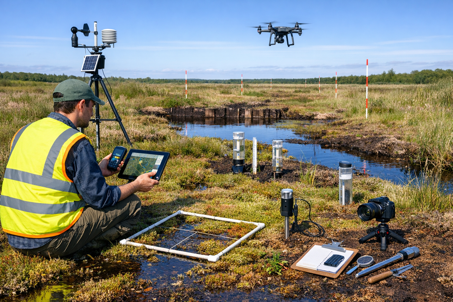
Advanced Survey Techniques for Peatland Rewetting Assessment
Measuring restoration success requires robust, repeatable survey methodologies that capture both immediate habitat changes and long-term ecological trajectories. The techniques employed in 2026 combine traditional ecological survey methods with cutting-edge technology.
Baseline Condition Assessment Protocols
Before any rewetting intervention, surveyors must establish comprehensive baseline data:
Hydrological Surveys
- Water table depth measurements using dipwell networks (minimum 5 wells per hectare)
- Seasonal monitoring to capture variation across wet and dry periods
- Hydraulic conductivity testing to understand peat permeability
- Surface water flow patterns and drainage network mapping
Vegetation Community Analysis
- National Vegetation Classification (NVC) surveys following standard methodology
- Quadrat-based sampling (typically 2m x 2m) at representative locations
- Species abundance recording using DAFOR or percentage cover scales
- Particular attention to Sphagnum moss species as key indicators of bog restoration success
Habitat Condition Assessment
- Application of statutory metric condition assessment sheets
- Documentation of negative indicators (drainage, burning, nutrient enrichment)
- Positive indicator recording (structural diversity, native species richness)
- Photographic documentation from fixed monitoring points
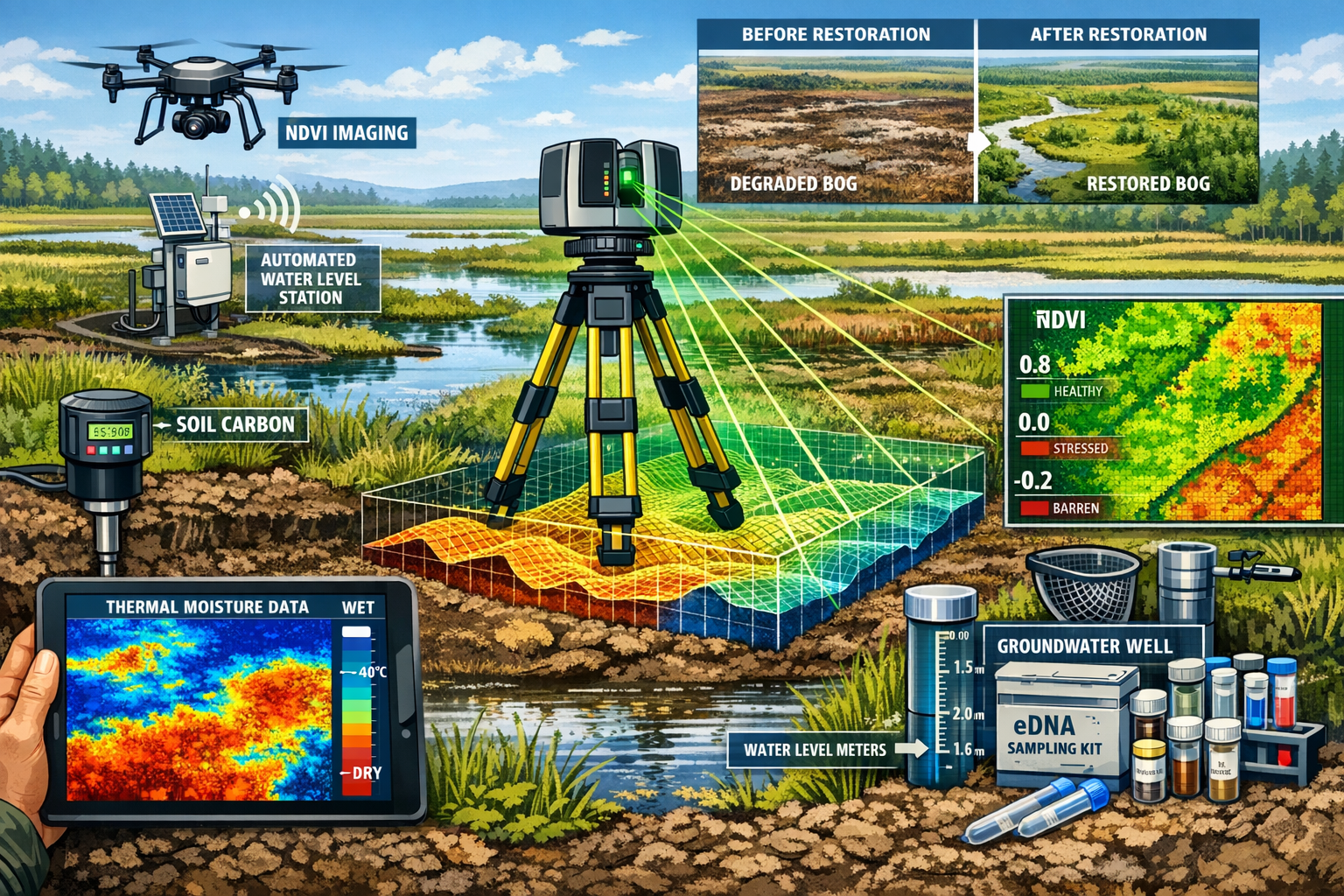
Innovative Technologies for Restoration Monitoring
Modern peatland surveying in 2026 leverages technological advances that were experimental just years ago:
Remote Sensing Applications 📡
- LiDAR (Light Detection and Ranging): Creates detailed elevation models showing microtopography changes, drainage patterns, and restoration intervention effectiveness
- Multispectral drone imagery: Captures vegetation health indices (NDVI) and moisture gradients across large areas
- Thermal infrared imaging: Identifies groundwater discharge zones and areas of active evapotranspiration
- Satellite-based monitoring: Enables landscape-scale assessment of vegetation change over time
Environmental DNA (eDNA) Analysis
Water and soil samples analyzed for genetic material provide comprehensive species inventories without extensive field surveys. This technique proves particularly valuable for:
- Detecting rare or cryptic species
- Monitoring invertebrate community recovery
- Assessing microbial community composition changes
- Tracking colonization by target peatland specialists
Automated Monitoring Systems
Permanent installations provide continuous data streams:
- Telemetry-enabled water level loggers transmitting real-time hydrological data
- Automated weather stations recording microclimate parameters
- Camera traps documenting wildlife usage and behavior
- Soil respiration chambers measuring carbon flux
Quantifying Biodiversity Unit Gains
The critical task for surveyors is translating ecological improvements into defensible biodiversity unit calculations. This requires:
- Accurate habitat typing using UK Habitat Classification
- Robust condition assessment following metric guidance
- Area measurement using GIS and verified ground-truthing
- Temporal accounting recognizing time-to-target condition
- Risk assessment applying appropriate difficulty multipliers
For peatland rewetting projects, typical biodiversity unit trajectories show:
| Timeframe | Condition | Unit Multiplier | Notes |
|---|---|---|---|
| Pre-restoration | Poor | 1.0 | Degraded, drained peatland |
| Years 1-3 | Poor-Moderate | 1.5 | Hydrological recovery phase |
| Years 4-10 | Moderate | 2.0 | Vegetation community transition |
| Years 11-20 | Moderate-Good | 2.5 | Sphagnum establishment |
| Years 20+ | Good | 3.0 | Mature restored bog |
Understanding how to achieve 10% biodiversity net gain through peatland projects requires careful projection of these trajectories.
Measuring Restoration Success: Key Performance Indicators for Peatland Rewetting
Peatland Rewetting for BNG: Advanced Survey Techniques for Measuring Restoration Success in 2026 depends on identifying and monitoring the right indicators. Success metrics must align with both ecological recovery goals and BNG regulatory requirements.
Primary Success Indicators
Hydrological Recovery 💧
Water table restoration represents the fundamental requirement for peatland recovery. Target metrics include:
- Mean annual water table: Within 10cm of surface for raised bogs
- Seasonal variation: Reduced amplitude compared to degraded baseline
- Spatial coverage: >90% of restoration area meeting water table targets
- Drainage network: Blocked ditches maintaining water retention
Research on trenching techniques has shown promising results for preventing water loss through underground cracks in afforested peatlands, particularly where conventional ditch blocking proves insufficient[1].
Vegetation Community Composition
The return of characteristic peatland plant communities provides visible evidence of restoration success:
- Sphagnum moss cover: Target >30% coverage for lowland raised bogs
- Bog specialist species: Presence and abundance of indicators like sundew, bog rosemary, cranberry
- Undesirable species decline: Reduction in Molinia, birch, and other indicators of degradation
- Structural diversity: Development of hummock-hollow microtopography
Carbon Function Restoration
While not directly part of BNG calculations, carbon metrics increasingly feature in 2026 project assessments:
- Net carbon balance: Transition from carbon source to carbon sink
- Methane emissions: Monitored but contextualized within overall greenhouse gas accounting
- Peat accumulation: Long-term indicator of bog function recovery
Secondary and Supporting Indicators
Faunal Community Recovery
Biodiversity gains extend beyond vegetation:
- Invertebrate assemblages: Specialist bog species including spiders, beetles, and dragonflies
- Breeding bird populations: Curlew, snipe, and other wading birds
- Mammal usage: Water vole, otter, and other wetland-dependent species
Ecosystem Function Metrics
- Water quality: Reduced dissolved organic carbon export, improved clarity
- Nutrient cycling: Oligotrophic conditions maintained or restored
- Hydrological regulation: Flood attenuation and water storage capacity
Survey Frequency and Duration
The 30-year habitat management and monitoring period required for BNG projects necessitates carefully planned survey schedules:
Intensive monitoring phase (Years 1-5)
- Quarterly water table measurements
- Annual vegetation surveys
- Biennial condition assessments
- Continuous automated data collection
Consolidation phase (Years 6-15)
- Biannual water table surveys
- Triennial vegetation monitoring
- Five-yearly comprehensive condition assessment
Maintenance phase (Years 16-30)
- Annual water table spot-checks
- Five-yearly full vegetation and condition surveys
- Ongoing automated monitoring system maintenance
This phased approach balances the need for evidence-based verification with practical resource constraints, ensuring biodiversity surveyors can deliver cost-effective monitoring programs.
Integrating Circular Finance and 2026 Sustainability Mandates
The evolution of environmental markets in 2026 has created new opportunities for funding peatland restoration through biodiversity unit sales while simultaneously delivering carbon and water quality benefits. This circular finance model aligns ecological restoration with economic sustainability.
Biodiversity Unit Generation and Trading
Peatland restoration projects can generate substantial biodiversity units for sale to developers requiring off-site biodiversity net gain solutions. The process involves:
Registration and Allocation
- Habitat baseline assessment using statutory metric
- Habitat creation or enhancement plan approval
- Registration on the biodiversity gain site register
- Legal agreement securing 30+ year management commitment
Unit Calculation
A typical 10-hectare lowland raised bog restoration might generate:
- Baseline: Degraded bog, Poor condition = 10 ha × 8 (distinctiveness) × 1.0 (condition) = 80 units
- Post-restoration: Good condition = 10 ha × 8 × 3.0 = 240 units
- Net gain: 160 biodiversity units available for allocation
Understanding the cost of biodiversity units helps landowners evaluate restoration project viability.
Stacking Environmental Benefits
The 2026 regulatory environment increasingly recognizes multiple benefit streams from nature-based solutions:
Carbon Credits
- Peatland Code certification for verified carbon units
- Emission reductions from prevented degradation
- Sequestration credits from restored carbon accumulation
- Corporate net-zero strategy integration
Water Quality Trading
- Nutrient reduction credits in catchment-based schemes
- Natural flood management benefits
- Water Framework Directive compliance contributions
Biodiversity Units
- Statutory BNG requirement fulfillment
- Voluntary corporate biodiversity commitments
- Nature recovery network contributions
"The integration of biodiversity, carbon, and water markets in 2026 has transformed peatland restoration from a conservation expense into a financially viable land use that delivers measurable environmental returns."
Ensuring Additionality and Avoiding Double-Counting
Critical to maintaining market integrity, surveyors must ensure:
- Additionality: Restoration wouldn't occur without market finance
- Permanence: Legal mechanisms securing long-term protection
- Transparency: Clear documentation of all benefit claims
- No double-counting: Each environmental benefit claimed only once across different schemes
The regulatory frameworks governing biodiversity net gain include specific provisions preventing the same habitat improvement from generating both biodiversity units and statutory biodiversity credits.
Practical Implementation: From Survey to Verified Gain
Translating survey data into verified biodiversity gains requires systematic processes that satisfy regulatory scrutiny while delivering genuine ecological outcomes.
Step-by-Step Implementation Protocol
Phase 1: Pre-Restoration Assessment (Months 1-3)
- Desktop study and historical analysis
- Comprehensive baseline surveys (hydrology, vegetation, fauna)
- Stakeholder consultation and permissions
- Metric calculation and unit projection
- Management plan development
Phase 2: Restoration Implementation (Months 4-12)
- Ditch blocking and bunding installation
- Tree removal where appropriate (afforested bogs)
- Application of innovative techniques like trenching for crack sealing[1]
- Installation of monitoring infrastructure
- Initial post-intervention surveys
Phase 3: Early Monitoring (Years 1-5)
- Intensive survey schedule implementation
- Adaptive management based on monitoring results
- Annual reporting to regulatory authorities
- Biodiversity unit allocation to developers
- Financial reconciliation and benefit stacking
Phase 4: Long-Term Stewardship (Years 6-30+)
- Reduced-intensity monitoring continuation
- Five-yearly comprehensive condition assessments
- Management intervention as needed
- Ongoing compliance verification
- Biodiversity unit maintenance and reporting
Common Challenges and Solutions
Challenge: Slow Vegetation Response
- Solution: Realistic trajectory modeling, patience, and appropriate risk multipliers in metric calculations
- Monitoring focus: Prioritize hydrological recovery as leading indicator
Challenge: Invasive Species Colonization
- Solution: Active management interventions, particularly for birch and Molinia control
- Survey protocol: Regular mapping of undesirable species extent
Challenge: Climate Variability Impact
- Solution: Drought contingency planning, resilient restoration design
- Monitoring adaptation: Extended baseline periods to capture natural variation
Challenge: Verification and Audit Requirements
- Solution: Robust data management systems, photographic evidence, independent verification
- Survey standards: Adherence to published methodologies and competency requirements
Quality Assurance and Competency
Ensuring survey quality requires:
- Surveyor qualifications: Appropriate ecological expertise and BNG metric competency
- Methodology standardization: Following published protocols and guidance
- Data management: Secure, auditable record-keeping systems
- Independent verification: Third-party review of calculations and claims
- Continuous professional development: Keeping current with evolving best practices
Organizations seeking to benefit from biodiversity surveying services should verify surveyor credentials and experience with peatland restoration projects.
Case Study Applications and Lessons Learned
While specific 2026 case studies are still emerging, the principles of Peatland Rewetting for BNG: Advanced Survey Techniques for Measuring Restoration Success in 2026 build on established restoration science and evolving BNG implementation.
Typical Project Profiles
Afforested Lowland Raised Bog Restoration
- Baseline condition: Conifer plantation on drained bog, Poor condition
- Intervention: Clear-felling, ditch blocking, trenching to prevent subsurface drainage[1]
- Monitoring focus: Water table recovery, Sphagnum recolonization, tree regeneration control
- Biodiversity unit trajectory: 5-7 years to Moderate condition, 15-20 years to Good condition
- Key success factor: Effective hydrological restoration preventing continued drainage
Blanket Bog Grip Blocking
- Baseline condition: Heavily gripped blanket bog, Poor to Moderate condition
- Intervention: Systematic grip blocking with peat dams
- Monitoring focus: Water table stabilization, erosion reduction, vegetation recovery
- Biodiversity unit trajectory: 3-5 years to Moderate condition, 10-15 years to Good condition
- Key success factor: Comprehensive blocking preventing bypass flow
Lowland Fen Rewetting
- Baseline condition: Agriculturally improved grassland on drained fen peat
- Intervention: Pump cessation, water level raising, scrub management
- Monitoring focus: Water chemistry, fen vegetation establishment, nutrient status
- Biodiversity unit trajectory: Variable depending on seed bank and propagule availability
- Key success factor: Appropriate water quality and level management
Critical Success Factors
Analysis of restoration projects reveals consistent themes:
✅ Hydrological understanding: Detailed assessment of water sources, flows, and losses
✅ Realistic expectations: Acknowledging that full restoration takes decades
✅ Adaptive management: Willingness to modify approaches based on monitoring results
✅ Stakeholder engagement: Securing buy-in from adjacent landowners and communities
✅ Adequate resourcing: Sufficient funding for both implementation and long-term monitoring
Future Developments and Emerging Technologies
The field of peatland restoration monitoring continues to evolve rapidly. Anticipated developments for late 2026 and beyond include:
Technological Advances
Artificial Intelligence and Machine Learning
- Automated vegetation classification from drone imagery
- Predictive modeling of restoration trajectories
- Anomaly detection in monitoring data streams
- Optimization of survey effort allocation
Enhanced Remote Sensing
- Hyperspectral imaging for detailed vegetation community mapping
- Synthetic aperture radar for all-weather monitoring
- Satellite-based water table estimation
- Continental-scale peatland condition assessment
Molecular Techniques
- Expanded eDNA applications for comprehensive biodiversity assessment
- Microbial community analysis as early restoration indicators
- Genetic diversity monitoring for key species populations
Policy and Market Evolution
The regulatory landscape continues to mature:
- Standardized protocols: Development of sector-specific guidance for peatland BNG projects
- Market transparency: Improved price discovery and unit trading mechanisms
- International linkages: Potential for UK biodiversity units to contribute to global biodiversity frameworks
- Enhanced enforcement: Stronger mechanisms ensuring delivery of promised gains
Organizations interested in selling biodiversity units from peatland restoration should stay informed about these evolving opportunities.
Conclusion
Peatland Rewetting for BNG: Advanced Survey Techniques for Measuring Restoration Success in 2026 represents a convergence of ecological science, regulatory compliance, and innovative finance mechanisms. As the UK's mandatory biodiversity net gain requirements mature, peatlands offer exceptional opportunities for delivering measurable environmental improvements while supporting sustainable development.
The key to success lies in rigorous survey methodologies that combine traditional ecological expertise with cutting-edge technologies. From baseline hydrological assessments through decades-long vegetation monitoring, biodiversity surveyors play a critical role in ensuring restoration projects deliver genuine, verifiable gains.
The integration of circular finance models—where peatland restoration generates revenue through biodiversity unit sales while delivering carbon and water quality co-benefits—has transformed the economic viability of large-scale restoration. This alignment of environmental and financial sustainability creates powerful incentives for landscape-scale peatland recovery.
Actionable Next Steps
For developers seeking biodiversity units:
- Explore off-site biodiversity unit purchasing from verified peatland restoration projects
- Engage early with peatland specialists to understand unit availability and timelines
- Consider the co-benefits of supporting peatland restoration for corporate sustainability reporting
For landowners with degraded peatlands:
- Commission baseline assessments to understand biodiversity unit generation potential
- Review guidance for landowners on participating in BNG markets
- Investigate funding mechanisms combining biodiversity, carbon, and water benefits
For biodiversity surveyors:
- Develop specialized competencies in peatland ecology and restoration monitoring
- Invest in technology platforms supporting long-term data management
- Stay current with evolving methodologies and regulatory requirements
For all stakeholders:
- Recognize that peatland restoration delivers multiple benefits beyond biodiversity
- Commit to the long-term monitoring and management essential for genuine restoration success
- Engage with the broader community working toward nature recovery at landscape scales
The restoration of the UK's degraded peatlands represents one of the most significant environmental opportunities of our generation. With robust survey techniques, clear regulatory frameworks, and innovative financing mechanisms now in place in 2026, the conditions exist for transformative change. The challenge now is implementation at the scale necessary to reverse decades of degradation and deliver lasting benefits for biodiversity, climate, and communities.
For expert guidance on peatland restoration projects and biodiversity net gain delivery, contact specialized biodiversity surveyors with proven experience in wetland habitat assessment and restoration monitoring.
References
[1] New Techniques For Peatland Restoration – https://www.forestresearch.gov.uk/news/new-techniques-for-peatland-restoration/
[2] Download – https://researchrepository.ucd.ie/bitstreams/11c69077-fb5a-4186-bc4e-c1aaab01999f/download
[3] Full – https://www.frontiersin.org/journals/environmental-science/articles/10.3389/fenvs.2022.942788/full
