
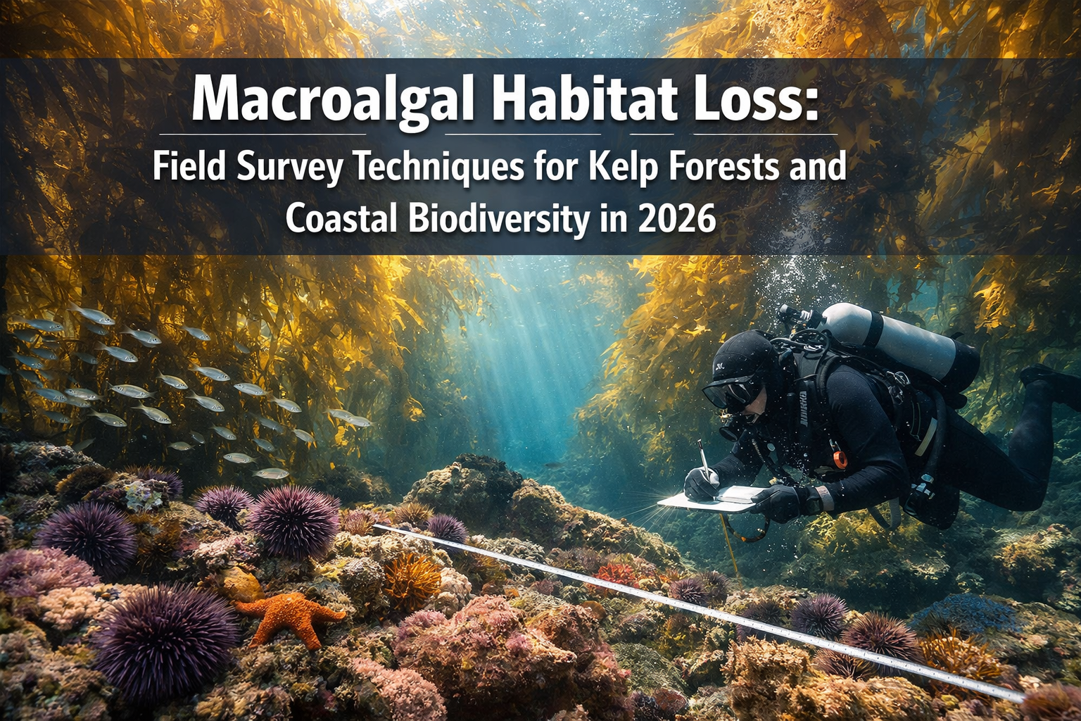
Ocean warming continues to drive unprecedented kelp forest decline across coastal ecosystems worldwide. As identified in the 2026 Horizon Scan for marine conservation priorities, macroalgal habitat loss represents one of the most critical threats to coastal biodiversity. Some California coastlines have experienced up to 95% kelp loss in recent years, driven by rising water temperatures and explosive sea urchin populations.[2] For biodiversity surveyors, marine ecologists, and conservation professionals working in 2026, understanding Macroalgal Habitat Loss: Field Survey Techniques for Kelp Forests and Coastal Biodiversity in 2026 has become essential for documenting ecosystem changes and informing strategic restoration efforts.
This comprehensive guide explores the cutting-edge field survey methodologies that professionals are deploying to monitor kelp forest dynamics, assess biodiversity impacts, and support evidence-based restoration planning in coastal marine environments.
Key Takeaways
- 🌊 Three primary survey methods dominate kelp forest monitoring in 2026: drone-based aerial imaging, satellite remote sensing, and SCUBA diver subtidal surveys—each providing complementary data at different scales
- 📊 Integrated monitoring approaches combining environmental sensor buoys with aerial and underwater surveys enable comprehensive assessment of both kelp canopy dynamics and the environmental variables driving habitat change
- 🔬 Standardized training programs like Reef Check certification courses are expanding surveyor capacity, teaching research diving techniques, sampling design theory, and species identification protocols
- 💰 Major funding initiatives including $5.8 million in new kelp research and restoration projects launched in 2024 are accelerating development of kelp forecasting tools and Indigenous-led monitoring programs
- 🎯 Strategic restoration planning requires baseline surveys, post-restoration monitoring, and grazer removal studies to evaluate recovery success and optimize intervention strategies
Understanding Macroalgal Habitat Loss and Its Impact on Coastal Ecosystems
Macroalgae—large marine algae including kelp species—form the structural foundation of some of Earth's most productive coastal ecosystems. Kelp forests provide critical habitat for hundreds of marine species, sequester significant amounts of carbon, protect shorelines from erosion, and support valuable commercial fisheries. When these underwater forests disappear, the cascading ecological and economic consequences ripple throughout coastal communities.
The Scale of Kelp Forest Decline
The magnitude of recent kelp forest losses has alarmed marine scientists and conservation professionals worldwide. Along the California coast, monitoring data reveals dramatic declines:
- 95% reduction in kelp coverage along some northern California stretches[2]
- Persistent urchin barrens replacing formerly thriving kelp forests
- Temperature anomalies creating conditions that favor grazers over kelp recovery
- Multi-year persistence of degraded states despite some environmental improvements
These losses are not isolated to California. Similar patterns of macroalgal habitat loss have been documented in Tasmania, Norway, Japan, and other temperate coastal regions globally, making effective survey techniques crucial for understanding and addressing this worldwide conservation challenge.
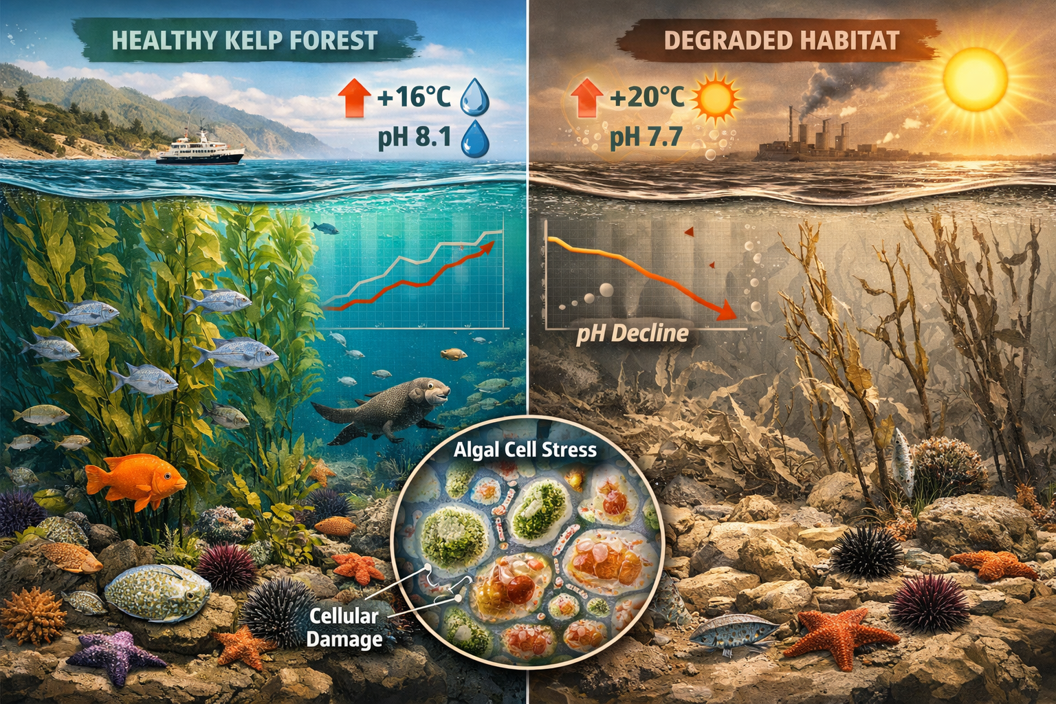
Key Drivers of Kelp Forest Decline
Understanding the mechanisms behind macroalgal habitat loss helps surveyors identify what to measure during field assessments:
Climate-Related Factors:
- Rising ocean temperatures reducing kelp growth and survival
- Marine heatwaves causing mass mortality events
- Changes in nutrient upwelling patterns
- Ocean acidification affecting kelp physiology
Biological Factors:
- Sea urchin population explosions creating grazing pressure
- Loss of predators (sea otters, sunflower sea stars) that control urchin populations
- Competition from invasive species
- Disease outbreaks affecting kelp or associated species
Human Activities:
- Coastal pollution and nutrient runoff
- Sedimentation from coastal development
- Overfishing of key species
- Direct physical damage from anchoring or dredging
Effective field surveys in 2026 must capture data on both kelp status and these driving variables to support comprehensive biodiversity impact assessments and restoration planning.
Primary Field Survey Techniques for Kelp Forest Monitoring in 2026
Modern kelp forest monitoring employs a multi-method approach, with each technique providing unique advantages for assessing different aspects of Macroalgal Habitat Loss: Field Survey Techniques for Kelp Forests and Coastal Biodiversity in 2026.
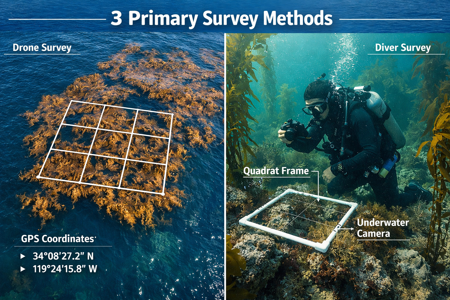
Unoccupied Aerial Systems (UAS/Drone) Surveys
Drone technology has emerged as a primary high-resolution imaging method for estimating kelp canopy area in 2026, offering significant advantages over traditional aircraft-based surveys.[1]
Key Capabilities:
- ✅ Map kelp forests near complex, rocky shorelines where aircraft cannot safely fly
- ✅ Distinguish between different kelp species based on canopy characteristics
- ✅ Detect sparse or patchy kelp canopy at local scales
- ✅ Provide cost-effective repeated surveys for temporal monitoring
- ✅ Generate high-resolution imagery for detailed analysis
Successful Implementation Examples:
Partner agencies including The Nature Conservancy and Greater Farallones National Marine Sanctuary have successfully demonstrated UAS capabilities for monitoring kelp canopy dynamics and strategic restoration planning off Sonoma and Mendocino counties' coastlines.[1] These programs integrate drone mapping with environmental sensor buoys to understand the conditions influencing kelp settlement and survival.[3]
Best Practices for Drone Surveys:
- Flight Planning: Conduct surveys during calm conditions with good water clarity
- Timing: Survey at low tide when kelp canopy is maximally exposed
- Resolution: Maintain altitude and camera settings to achieve 5-10 cm ground resolution
- Coverage: Use systematic grid patterns with 60-80% image overlap
- Calibration: Include ground control points or GPS-tagged reference locations
- Frequency: Repeat surveys quarterly or seasonally to capture temporal dynamics
Satellite Remote Sensing
Satellite imagery provides the broadest spatial coverage for kelp forest monitoring, enabling coastwide assessments that would be impractical with other methods.
Current Operational Systems:
The Santa Barbara Coastal Long-Term Ecological Research program (LTER) processes Landsat imagery to provide ongoing monitoring of combined giant kelp and bull kelp canopy area across the entire California coast.[1] This long-term dataset enables detection of multi-year trends and large-scale patterns in kelp distribution.
Advantages:
- 🌍 Large spatial coverage (entire coastlines)
- 📅 Historical data availability (decades of archived imagery)
- 💵 Cost-effective for broad-scale monitoring
- 🔄 Regular revisit intervals (every 16 days for Landsat)
Limitations:
- Lower spatial resolution compared to drones (30m pixels for Landsat)
- Cloud cover can obscure imagery
- Cannot detect subsurface kelp or sparse canopy
- Limited species differentiation
Integration with Other Methods:
Satellite data works best when integrated with higher-resolution drone surveys and ground-truthing through diver surveys. This multi-scale approach enables both broad regional assessments and detailed local monitoring.
SCUBA Diver Subtidal Surveys
Underwater diving surveys remain the gold standard for assessing kelp forest biodiversity and structural characteristics that aerial methods cannot capture.[1]
Critical Data Collected:
- 🌿 Kelp density (number of plants per unit area)
- 📏 Size structure (stipe length, frond counts, holdfast diameter)
- 🐟 Associated species diversity and abundance
- 🪨 Substrate characteristics
- 🦔 Grazer populations (urchins, snails)
- 🌡️ In-situ environmental conditions
Long-Term Monitoring Programs:
The California Department of Fish and Wildlife's north coast nearshore ecosystem dive surveys began in 1971 and continue to collect invaluable long-term data on kelp forest communities.[1] These multi-decade datasets enable detection of subtle changes and establishment of baseline conditions for restoration efforts.
Standardized Survey Protocols:
Reef Check Kelp Forest Monitoring Training programs are actively recruiting participants in 2026, offering certification courses that teach:[5]
- Survey methods and sampling design theory
- Safe diving practices and research diving techniques
- Marine ecology principles
- Species identification for key indicator organisms
- Data recording and quality control procedures
- Statistical analysis basics
These standardized protocols ensure data comparability across sites and monitoring programs, supporting biodiversity net gain objectives in marine environments.
Survey Design Considerations:
Effective diver surveys typically employ:
- Transect-based sampling: Permanent transects for temporal comparisons
- Quadrat methods: Standardized area sampling for density estimates
- Roving diver surveys: Broader species inventories
- Photo/video documentation: Permanent visual records for verification
- Replicate sampling: Multiple transects or quadrats per site for statistical power
Environmental Sensor Deployments
Sensor buoys and data loggers provide continuous monitoring of the environmental variables influencing kelp forest dynamics, complementing the snapshot data from surveys.
Key Parameters Monitored:
- Water temperature (critical for kelp growth)
- Light availability (photosynthetically active radiation)
- Nutrient concentrations (nitrogen, phosphorus)
- Wave action and current velocity
- Salinity and pH
- Dissolved oxygen
Environmental sensor buoys are deployed at restoration sites alongside drone mapping to understand the conditions influencing kelp settlement and survival.[3] This integrated approach enables development of kelp forecasting tools that identify monthly and seasonal environmental factors that help or hinder kelp recovery—similar to agricultural planting and harvesting forecast tools.[2]
Implementing Comprehensive Biodiversity Surveys in Kelp Forest Ecosystems
Assessing coastal biodiversity impacts from Macroalgal Habitat Loss: Field Survey Techniques for Kelp Forests and Coastal Biodiversity in 2026 requires surveying not just kelp itself, but the entire associated community of organisms that depend on kelp forest habitat.
Multi-Taxa Inventory Approaches
Comprehensive biodiversity surveys document:
Primary Producers:
- Multiple kelp species (giant kelp, bull kelp, other brown algae)
- Understory algae (red and green algae)
- Surfgrass and eelgrass in adjacent habitats
Invertebrates:
- Sea urchins (purple, red) and other grazers
- Abalone and other mollusks
- Crustaceans (crabs, shrimp, lobsters)
- Sea stars and other echinoderms
- Sessile invertebrates (sponges, tunicates, bryozoans)
Vertebrates:
- Rockfish and other reef-associated fish
- Kelp forest specialists (kelp bass, señorita, kelp perch)
- Transient species using kelp as nursery habitat
- Marine mammals (sea otters, seals, sea lions)
- Seabirds foraging in kelp forests
Sampling Design Principles
Effective biodiversity surveys follow established ecological sampling principles:
Stratification: Divide survey areas into meaningful strata (depth zones, substrate types, exposure levels) and sample proportionally from each.
Randomization: Use random or systematic-random site selection within strata to avoid bias.
Replication: Include sufficient replicate samples to estimate variability and detect statistically meaningful changes.
Controls: Compare impacted sites to reference sites with intact kelp forests when possible.
Temporal Coverage: Conduct surveys across seasons to capture seasonal variation in species composition and abundance.
These principles align with biodiversity assessment methodologies used in terrestrial environments, adapted for marine contexts.
Data Management and Quality Control
Professional survey programs implement rigorous data management:
- Standardized datasheets: Consistent recording formats across surveys
- Species verification: Expert taxonomic confirmation of identifications
- Digital data entry: Immediate transcription to reduce errors
- Quality assurance protocols: Systematic checks for outliers and inconsistencies
- Metadata documentation: Complete recording of survey conditions and methods
- Data archiving: Long-term storage in accessible databases
Integration with Restoration Monitoring
Biodiversity surveys serve dual purposes in kelp forest conservation:
- Baseline Assessment: Document pre-restoration conditions
- Impact Monitoring: Track changes during habitat loss
- Restoration Evaluation: Measure recovery success post-intervention
- Adaptive Management: Inform adjustments to restoration strategies
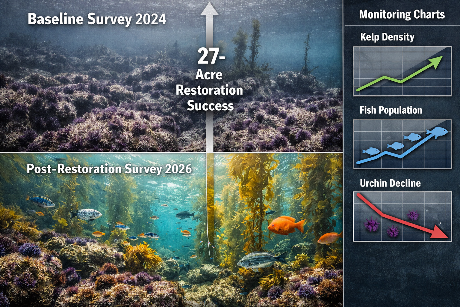
The 27-acre kelp restoration project at three locations within Greater Farallones National Marine Sanctuary exemplifies this integrated approach, with comprehensive monitoring planned before, during, and after restoration interventions.[3]
Kelp Restoration Monitoring and Grazer Removal Studies
Understanding Macroalgal Habitat Loss: Field Survey Techniques for Kelp Forests and Coastal Biodiversity in 2026 extends beyond documentation to include monitoring restoration effectiveness and experimental manipulations.
Commercial Urchin Harvesting as Restoration Tool
Commercial urchin diver hand-harvesting has been selected as the primary method to remove thousands of pounds of purple sea urchins at restoration sites.[3] This approach provides multiple benefits:
- ✅ Supports local jobs for commercial urchin divers
- ✅ Benefits small businesses in coastal communities
- ✅ Provides selective removal targeting problem areas
- ✅ Avoids chemical or mechanical disturbance methods
- ✅ Generates economic value from harvested urchins
Monitoring Requirements:
Restoration projects require systematic surveys to evaluate:
- Pre-removal urchin density and biomass
- Urchin population recovery rates post-removal
- Kelp recruitment and growth following urchin reduction
- Non-target species responses
- Cost-effectiveness of different removal intensities and frequencies
Experimental Grazer Removal Studies
Kelp grazer removal studies are underway examining how clearing different combinations of herbivores affects recovery.[2] These experiments test:
Treatment Comparisons:
- Red urchin removal only
- Purple urchin removal only
- Combined urchin species removal
- Urchin + wavy turban snail removal
- Removal at kelp forest edges vs. centers
- Different clearing frequencies (monthly, quarterly, annually)
Evaluation Metrics:
- Kelp recruitment rates
- Kelp growth and survival
- Time to canopy closure
- Associated species colonization
- Financial costs per treatment
- Labor requirements
These studies directly inform achieving biodiversity net gain in marine restoration contexts by identifying the most effective and efficient intervention strategies.
Post-Restoration Success Monitoring
Summer restoration initiation is planned following urchin removal efforts at Greater Farallones sites.[3] Post-restoration monitoring tracks:
Short-term Indicators (0-2 years):
- Kelp sporophyte recruitment
- Juvenile kelp survival
- Growth rates of establishing plants
- Grazer recolonization patterns
Medium-term Indicators (2-5 years):
- Canopy development and closure
- Reproductive maturity of kelp populations
- Fish and invertebrate community recovery
- Ecosystem function restoration (productivity, carbon sequestration)
Long-term Indicators (5+ years):
- Self-sustaining kelp populations
- Resilience to environmental variability
- Full biodiversity recovery
- Ecosystem service provision
Emerging Technologies and Indigenous-Led Monitoring Programs
The field of kelp forest monitoring continues to evolve with new technologies and inclusive approaches that expand surveyor capacity and integrate traditional ecological knowledge.
Advanced Forecasting Tools
Kelp forecasting tools under development in 2026 enable timely decision-making for restoration by identifying monthly and seasonal environmental factors that help or hinder kelp recovery.[2] These tools integrate:
- Historical kelp abundance data
- Environmental variables (temperature, nutrients, light)
- Grazer population dynamics
- Oceanographic models
- Machine learning algorithms
Similar to agricultural planting and harvesting forecasts, these tools help restoration practitioners identify optimal timing for interventions and predict likely success under current conditions.
Indigenous-Led Monitoring and Restoration
Indigenous-led monitoring and restoration training programs are establishing new models for inclusive conservation.[2] The Tolowa Dee-ni' Nation program exemplifies this approach:
Program Components:
- Training up to ten Natural Resources Staff and Tribal Citizens
- Kelp monitoring techniques instruction
- Restoration methodology training
- Nursery and grow-out site establishment
- Integration of traditional ecological knowledge
- Template development for other tribes
This model recognizes that Indigenous communities have stewarded coastal ecosystems for millennia and brings traditional knowledge into dialogue with Western scientific approaches.
Citizen Science and Community Engagement
Expanding monitoring capacity requires engaging broader communities in data collection. Programs like Reef Check train recreational divers to contribute to scientific monitoring efforts.[5] Benefits include:
- Increased spatial and temporal survey coverage
- Enhanced public awareness and stewardship
- Cost-effective data collection
- Community connection to local marine ecosystems
- Pipeline for future marine science professionals
Integration with Biodiversity Net Gain Frameworks
While most biodiversity net gain frameworks have focused on terrestrial environments, the principles increasingly apply to marine contexts. Kelp forest restoration and monitoring can contribute to biodiversity net gain objectives by:
- Documenting baseline marine biodiversity
- Quantifying habitat losses from development or climate impacts
- Designing compensatory restoration projects
- Monitoring restoration success against targets
- Ensuring no net loss of marine biodiversity
As coastal development continues, integrating kelp forest conservation into biodiversity planning frameworks becomes increasingly important.
Funding Opportunities and Research Initiatives
The urgency of kelp forest decline has catalyzed significant investment in research and restoration, creating opportunities for surveyors and conservation professionals.
Major Funding Programs
$5.8 million in new research and restoration projects launched in 2024 specifically focus on kelp recovery, investigating:[2]
- Optimal growth conditions for different kelp species
- Kelp resilience to warming waters
- Genetic diversity and adaptation potential
- Scaling up restoration techniques
- Economic valuation of kelp forest ecosystem services
- Empowering California Native American tribes in restoration efforts
These investments support development of improved survey methodologies, expanded monitoring networks, and evidence-based restoration strategies.
Research Priorities for 2026
Current research initiatives address critical knowledge gaps:
Ecological Questions:
- What environmental thresholds determine kelp recovery vs. persistence of urchin barrens?
- How does genetic diversity affect kelp resilience to warming?
- What role do kelp forests play in coastal carbon sequestration?
- How do different restoration approaches compare in effectiveness and cost?
Methodological Innovations:
- Machine learning for automated kelp identification in imagery
- Environmental DNA (eDNA) for biodiversity assessment
- Acoustic monitoring for fish community assessment
- Integration of multiple data streams for comprehensive ecosystem monitoring
Social Dimensions:
- Community engagement strategies for restoration projects
- Economic valuation of kelp forest ecosystem services
- Policy frameworks supporting kelp conservation
- Traditional ecological knowledge integration
Career Opportunities in Kelp Forest Monitoring
The expansion of kelp monitoring and restoration creates diverse career opportunities:
- Field Technicians: Conducting surveys and data collection
- Drone Operators: Specialized UAS pilots for marine applications
- Scientific Divers: Research diving for underwater surveys
- Data Analysts: Processing and interpreting monitoring data
- Restoration Ecologists: Designing and implementing restoration projects
- Community Coordinators: Engaging stakeholders in monitoring programs
Professional development through programs like Reef Check certification provides pathways into these careers.[5]
Conclusion: The Path Forward for Kelp Forest Conservation
Macroalgal Habitat Loss: Field Survey Techniques for Kelp Forests and Coastal Biodiversity in 2026 represents a critical intersection of conservation urgency and methodological innovation. As ocean warming continues to challenge kelp forest ecosystems worldwide, the survey techniques and monitoring frameworks described in this guide provide essential tools for documenting change, informing restoration, and supporting evidence-based conservation decisions.
Key Actions for Surveyors and Conservation Professionals
Immediate Steps:
- Acquire training in standardized kelp forest survey methods through programs like Reef Check
- Adopt integrated monitoring approaches combining aerial, satellite, and diver surveys
- Implement rigorous data management protocols to ensure long-term data utility
- Engage with restoration projects to contribute baseline and post-restoration monitoring
- Collaborate across disciplines to integrate ecological, social, and economic perspectives
Strategic Priorities:
- Support development of kelp forecasting tools to optimize restoration timing
- Participate in Indigenous-led monitoring programs that integrate traditional knowledge
- Contribute to expanding geographic coverage of monitoring networks
- Advocate for sustained funding for long-term monitoring programs
- Apply biodiversity assessment principles to marine conservation contexts
The Broader Conservation Context
Kelp forest conservation connects to larger biodiversity challenges facing coastal ecosystems. The monitoring techniques and restoration approaches developed for kelp forests provide models applicable to other marine habitats experiencing climate-driven changes. By documenting losses, understanding drivers, and evaluating restoration effectiveness, surveyors contribute essential knowledge for adaptive management in an era of rapid environmental change.
The 27-acre restoration project at Greater Farallones National Marine Sanctuary and similar initiatives worldwide demonstrate that recovery is possible with strategic intervention and sustained monitoring.[3] Success requires continued investment in survey capacity, methodological innovation, and collaborative approaches that engage diverse stakeholders in stewardship of these vital coastal ecosystems.
For biodiversity surveyors working in 2026, kelp forests offer both challenges and opportunities—ecosystems in crisis that demand our best science, most innovative techniques, and deepest commitment to conservation. The field survey techniques outlined in this guide provide the foundation for meeting that challenge and contributing to the recovery of these underwater forests and the remarkable biodiversity they support.
References
[1] Monitoring – https://wildlife.ca.gov/Conservation/Marine/Kelp/Monitoring
[2] Kelp Research – https://caseagrant.ucsd.edu/kelp-research
[3] Pioneering Project Restore Bull Kelp Forests Greater Farallones National Marine – https://www.fisheries.noaa.gov/feature-story/pioneering-project-restore-bull-kelp-forests-greater-farallones-national-marine
[5] 2026 Kelp Forest Monitoring Trainings Now Open Register Today – https://www.reefcheck.org/2026-kelp-forest-monitoring-trainings-now-open-register-today/
