
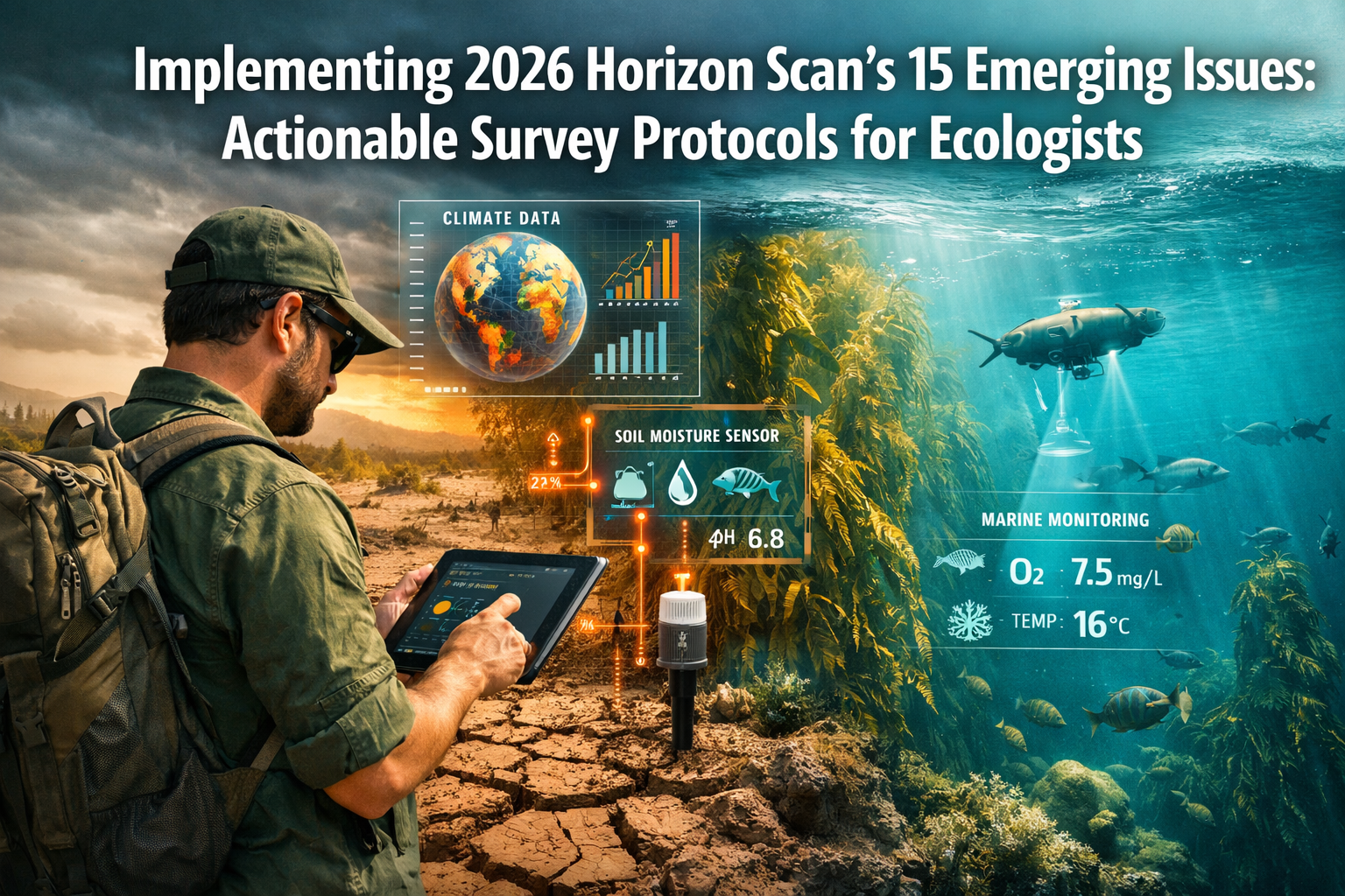
The ecological landscape is changing faster than ever before. Ocean waters are darkening, soil moisture is declining across entire continents, and kelp forests larger than all coral reefs combined face unprecedented threats. For biodiversity surveyors and field ecologists working in 2026, staying ahead of these emerging challenges isn't just about reading scientific papers—it's about translating cutting-edge research into practical, boots-on-the-ground survey protocols. The 2026 Global Horizon Scan has identified 15 critical emerging issues that demand immediate attention from conservation professionals. This comprehensive guide breaks down Implementing 2026 Horizon Scan's 15 Emerging Issues: Actionable Survey Protocols for Ecologists into practical workflows that can be integrated into current biodiversity assessment practices.
Key Takeaways
- 🌍 The 2026 Horizon Scan identifies 15 critical emerging issues including soil moisture decline, ocean darkening, and macroalgal habitat loss that require immediate surveyor attention
- 📊 Practical field protocols can integrate horizon scan findings into existing biodiversity assessment workflows using accessible technology like TinyML devices and digital twins
- 🔬 Soil moisture monitoring across survey sites provides early warning data for ecosystem destabilization, with protocols requiring minimal additional equipment
- 🌊 Marine survey adaptations for ocean darkening and kelp forest assessment can be incorporated into standard coastal biodiversity evaluations
- 💡 Technology integration including optical AI chips and tiny machine learning enables real-time species detection in remote locations without internet connectivity
Understanding the 2026 Horizon Scan Framework
The 2026 Horizon Scan represents a collaborative effort by 26 scientists, practitioners, and policymakers who assessed 96 initial conservation issues, discussed the highest-ranked 35, and ultimately identified 15 top-priority concerns for the global conservation community[4]. Unlike previous horizon scans that focused primarily on threats, this year's assessment balances emerging challenges with promising opportunities—from innovative technologies to new funding mechanisms.
For biodiversity surveyors, this framework provides a structured approach to anticipating and responding to rapid ecological changes. The scan methodology prioritizes issues that are:
- Novel or emerging rather than well-established concerns
- Likely to have significant impact on biodiversity conservation
- Actionable with current or near-future tools and methods
- Underrepresented in current conservation discourse
Understanding this framework helps ecologists prioritize which emerging issues to integrate into their survey protocols based on regional relevance and available resources. The benefitting nature and developers with biodiversity surveyors approach demonstrates how forward-thinking survey practices create value for multiple stakeholders.
Critical Environmental Changes Requiring Protocol Adaptation
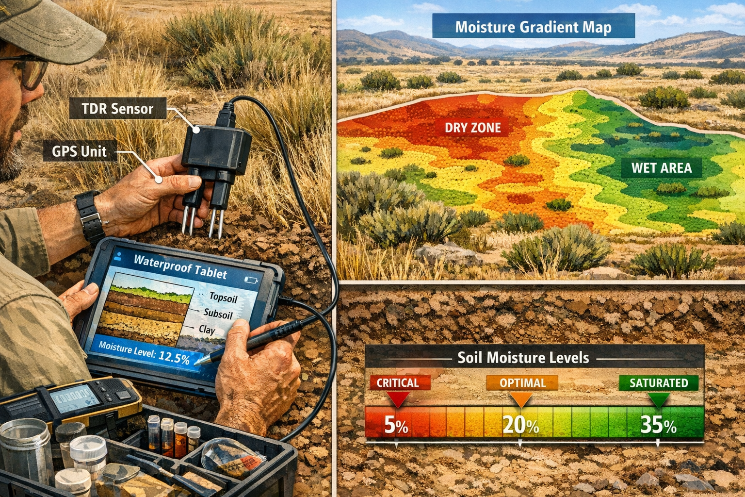
Soil Moisture Decline: Terrestrial Survey Integration
Soil moisture decline across southern South America, central North America, Africa, and Asia is destabilizing both terrestrial and freshwater ecosystems, with profound implications for food production and water security[1]. This widespread phenomenon has already contributed to ocean level rise exceeding 1 centimeter as water shifts from land to sea.
Actionable Survey Protocol:
- Baseline Moisture Assessment: Incorporate soil moisture measurements into standard habitat surveys using affordable Time Domain Reflectometry (TDR) sensors or gravimetric sampling
- Stratified Sampling Design: Collect moisture readings at multiple depths (0-10cm, 10-30cm, 30-60cm) across representative habitat types
- Temporal Monitoring: Establish quarterly measurement schedules to track seasonal variation and long-term trends
- Threshold Documentation: Record vegetation stress indicators (leaf wilting, growth reduction, species composition shifts) alongside moisture data
- Data Integration: Link moisture readings with existing biodiversity metrics to identify vulnerability thresholds for key species
Equipment Requirements:
- Handheld soil moisture probe (£150-400)
- GPS unit for georeferencing sample points
- Waterproof data logger or tablet
- Sample collection kit for laboratory verification
This protocol adds approximately 15-20 minutes per survey plot but provides critical early warning data for ecosystem destabilization. The information directly supports biodiversity impact assessments by documenting baseline conditions that may shift rapidly under changing moisture regimes.
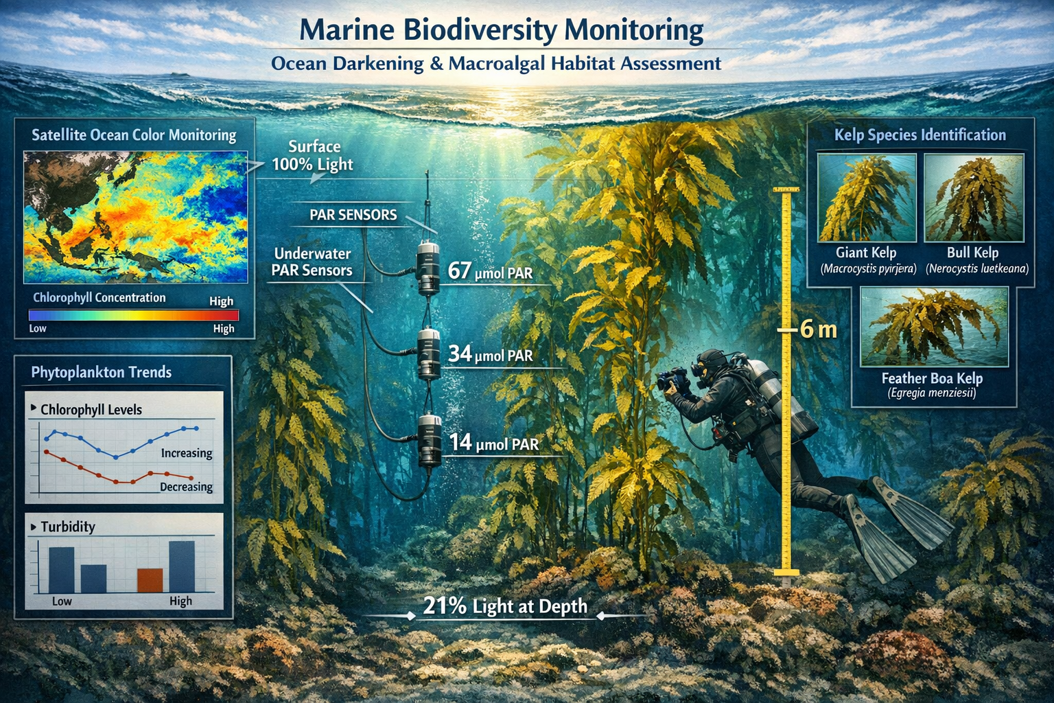
Ocean Darkening and Light Penetration Changes
Satellite data reveals that ocean light penetration declined by 21% between 2003 and 2022[2], a dramatic change with potential cascading effects on phytoplankton productivity and marine food webs. This "ocean darkening" phenomenon disrupts photosynthesis in surface waters and alters the vertical distribution of marine life.
Actionable Survey Protocol:
- Light Penetration Measurement: Use Secchi disks or PAR (Photosynthetically Active Radiation) sensors to document water clarity and light availability at survey sites
- Phytoplankton Sampling: Collect water samples for chlorophyll-a analysis to assess primary productivity changes
- Depth Distribution Documentation: Record depth ranges where key species are observed, noting any shifts from historical baselines
- Visual Clarity Assessment: Photograph standardized underwater targets at fixed distances to create comparable visual records
- Correlation Analysis: Compare light penetration data with fish abundance, invertebrate diversity, and macroalgal health metrics
Integration Points:
- Coastal development assessments
- Marine protected area monitoring
- Climate change impact studies
- Fisheries habitat evaluations
This protocol requires minimal additional equipment beyond standard marine survey gear and provides quantitative data on a globally significant but locally observable phenomenon.
Macroalgal Habitat Loss: Kelp Forest Assessment
Kelp forests and other macroalgal habitats currently cover more area than coral reefs and coastal wetlands combined, yet face multiple threats including climate change, overgrazing by sea urchins, and pollution[2]. These underwater forests provide critical habitat for commercially important fish species and sequester significant amounts of carbon.
Actionable Survey Protocol:
- Canopy Structure Assessment: Establish permanent transects to measure kelp density, canopy height, and percent cover
- Health Indicators: Document blade condition, epiphyte load, and reproductive structure presence
- Herbivore Pressure: Conduct quadrat surveys of sea urchin and other grazer populations
- Recruitment Monitoring: Track juvenile kelp establishment in designated monitoring plots
- Thermal Stress Markers: Record water temperature alongside biological metrics to identify heat stress thresholds
Survey Frequency Recommendations:
- Quarterly surveys for high-priority sites
- Annual surveys for broader monitoring networks
- Post-storm assessments following major weather events
The data collected through this protocol directly informs biodiversity net gain strategies for coastal developments and marine restoration projects.
Implementing 2026 Horizon Scan's 15 Emerging Issues Through Technology Integration
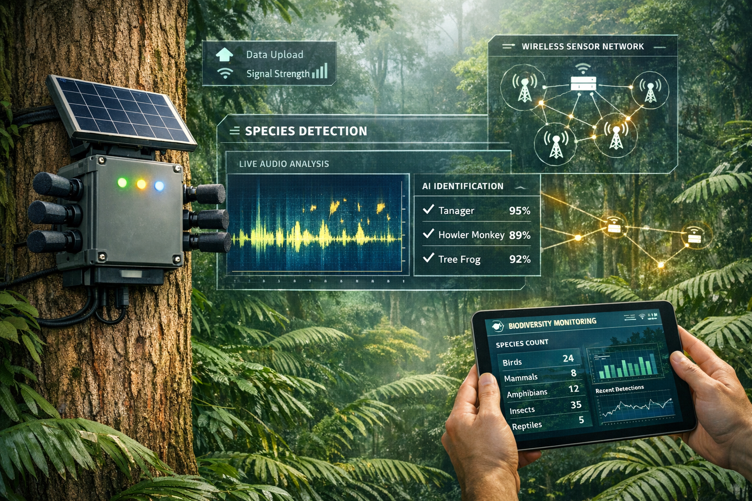
Tiny Machine Learning (TinyML) for Remote Biodiversity Detection
TinyML devices represent a breakthrough for field ecologists, enabling real-time biodiversity detection in remote landscapes without requiring internet connectivity[1]. These compact, low-power devices use artificial intelligence to identify species from acoustic signals, camera trap images, or environmental DNA samples—all while operating on battery power for months.
Implementation Strategy:
Phase 1: Equipment Selection and Deployment
- Select TinyML devices appropriate for target taxa (acoustic monitors for birds/bats, camera systems for mammals, water samplers for aquatic eDNA)
- Deploy devices in grid patterns or along transects based on survey objectives
- Configure devices for target species detection using pre-trained AI models
Phase 2: Data Collection and Validation
- Allow devices to collect data continuously or at programmed intervals
- Download data during quarterly site visits
- Validate AI identifications with expert review of flagged detections
Phase 3: Integration with Traditional Surveys
- Compare TinyML detection rates with conventional survey methods
- Use continuous monitoring data to optimize timing of human survey visits
- Identify rare species or unusual activity patterns for targeted investigation
Cost-Benefit Analysis:
- Initial investment: £300-800 per device
- Reduced labor costs: 40-60% fewer field hours required
- Improved detection: 2-3x more species documented compared to point counts alone
- Data continuity: 24/7 monitoring versus snapshot surveys
This technology is particularly valuable for biodiversity net gain assessments where demonstrating species presence over time strengthens baseline documentation.
Optical AI Chips and Energy-Efficient Monitoring
Optical AI chip technologies use light rather than electricity to process information, dramatically enhancing energy efficiency for conservation monitoring in remote locations[2]. These emerging systems can operate on minimal solar power while performing complex species identification and behavior analysis tasks.
Practical Applications for Surveyors:
- Extended Deployment Periods: Optical AI systems can operate for 6-12 months on small solar panels, reducing site visit frequency
- Real-Time Processing: Data is analyzed on-device, eliminating the need to store and transmit large image or audio files
- Multi-Sensor Integration: Single systems can process inputs from cameras, microphones, and environmental sensors simultaneously
- Adaptive Sampling: Devices can adjust sampling intensity based on detected activity levels, maximizing battery life
Deployment Considerations:
- Best suited for long-term monitoring sites rather than rapid assessments
- Requires initial investment in training AI models for target species
- Most effective when integrated with existing monitoring infrastructure
- Particularly valuable for protected areas and biodiversity unit creation
Digital Twins for Ecological System Modeling
Digital twins technology creates computer simulations of real-world ecological systems and processes[1], allowing ecologists to model potential impacts before they occur and test management interventions virtually before implementing them in the field.
Survey Protocol Integration:
Step 1: Data Collection for Model Building
- Collect comprehensive baseline data including species inventories, habitat structure, soil properties, hydrology, and microclimate
- Document spatial relationships using GIS mapping and photogrammetry
- Measure process rates (decomposition, nutrient cycling, water infiltration)
Step 2: Digital Twin Construction
- Partner with modeling specialists to build digital representations of survey sites
- Validate model outputs against observed ecological patterns
- Refine models with additional field data as needed
Step 3: Scenario Testing
- Model potential impacts of proposed developments or management actions
- Test climate change scenarios using projected temperature and precipitation data
- Evaluate restoration strategies before implementation
Step 4: Adaptive Management
- Update digital twins with ongoing monitoring data
- Use models to predict optimal timing for interventions
- Track actual versus predicted outcomes to improve model accuracy
This approach is particularly powerful for planning biodiversity net gain strategies where developers need to demonstrate long-term habitat viability.
Southern Ocean Salinity Changes and Global Circulation Monitoring
The Southern Ocean shows unexpected increases in surface water salinity over the past decade, with unknown implications for ice melting and global circulation patterns[2]. While this may seem distant from typical surveyor concerns, these changes affect global weather patterns and ultimately influence local ecosystems worldwide.
Surveyor Contribution Protocol:
Even terrestrial ecologists can contribute valuable data to understanding these global patterns through:
- Precipitation Chemistry Sampling: Collect rainwater samples quarterly to document changes in atmospheric moisture sources
- Phenology Monitoring: Record timing of seasonal events (leaf-out, flowering, migration) that may shift with altered weather patterns
- Extreme Weather Documentation: Maintain detailed records of drought, flooding, and temperature extremes at survey sites
- Species Range Shifts: Document colonization by species from warmer or cooler regions
Data Sharing:
- Submit observations to national phenology networks
- Contribute to citizen science platforms like iNaturalist for range documentation
- Share weather data with meteorological services
- Coordinate with oceanographic institutions for integrated analysis
This protocol requires minimal additional effort but connects local survey work to global conservation challenges, demonstrating the value of comprehensive biodiversity surveying approaches.
Chemical Plant Development Compounds and Conservation Applications
Researchers have screened 16,000 chemical compounds and identified several that slow flowering in plants, potentially helping threatened species reproduce under stress and maintain crop productivity during climate disruption[2]. This breakthrough offers new tools for conservation management.
Survey Protocol for Testing Applications:
Pre-Treatment Assessment:
- Select target species populations showing reproductive stress
- Document baseline flowering phenology, seed set, and recruitment rates
- Establish treatment and control plots with matched site conditions
- Collect genetic samples to assess population diversity
Treatment Implementation:
- Apply compounds according to research protocols during critical developmental windows
- Monitor for non-target effects on pollinators and associated species
- Document flowering duration, seed production, and seedling establishment
- Compare results between treated and control populations
Long-Term Monitoring:
- Track population persistence and growth over 3-5 year periods
- Assess genetic diversity maintenance in treated populations
- Evaluate cost-effectiveness compared to traditional interventions
- Document any unintended ecological consequences
Regulatory Considerations:
- Obtain necessary permits for chemical applications in natural areas
- Follow biosafety protocols for experimental treatments
- Coordinate with land managers and regulatory authorities
- Document procedures for potential future approval processes
This experimental protocol is most appropriate for rare plant conservation projects and may eventually inform biodiversity enhancement strategies for development sites.
Tropical Forest Conservation Finance and Survey Implications
The new $125 billion Tropical Forests Forever Facility investment fund led by Brazil represents a major shift in conservation finance, rewarding countries for protecting forests rather than just penalizing deforestation[2]. This funding mechanism creates new opportunities and requirements for biodiversity surveyors.
Survey Protocol Adaptations for Performance-Based Funding:
Enhanced Monitoring Requirements:
- Continuous Forest Cover Assessment: Integrate remote sensing analysis with ground-truthing surveys
- Biodiversity Indicator Tracking: Establish permanent monitoring plots for flagship species and ecological integrity indicators
- Carbon Stock Measurement: Add forest structure surveys (tree diameter, height, density) to quantify carbon sequestration
- Community Impact Assessment: Document sustainable use by local communities to demonstrate social co-benefits
Verification Standards:
- Follow internationally recognized protocols (e.g., REDD+, Verified Carbon Standard)
- Maintain transparent, auditable data management systems
- Conduct regular third-party verification surveys
- Implement quality control procedures for all field data
Reporting Framework:
- Quarterly progress reports with key indicator updates
- Annual comprehensive assessments with statistical analysis
- Five-year evaluation of long-term trends and program effectiveness
- Adaptive management recommendations based on monitoring results
Capacity Building:
- Train local surveyors in standardized protocols
- Establish regional reference collections for species identification
- Develop technology infrastructure for data management
- Create partnerships with academic institutions for technical support
This approach aligns with broader biodiversity net gain principles by demonstrating measurable conservation outcomes that justify financial investment.
Practical Workflow Integration: A Step-by-Step Approach
Successfully implementing 2026 Horizon Scan's 15 emerging issues requires thoughtful integration into existing survey workflows rather than complete protocol overhauls. Here's a practical roadmap:
Phase 1: Assessment and Prioritization (Weeks 1-2)
Action Steps:
- Review all 15 horizon scan issues and identify 3-5 most relevant to your geographic region and survey focus
- Assess current survey protocols to identify integration opportunities
- Evaluate equipment needs and budget requirements
- Consult with clients or project managers about expanded scope
Decision Matrix:
| Issue | Regional Relevance | Equipment Cost | Time Investment | Priority Ranking |
|---|---|---|---|---|
| Soil moisture decline | High | Low | Medium | 1 |
| Ocean darkening | Medium | Medium | Low | 3 |
| TinyML integration | High | High | Low | 2 |
Phase 2: Pilot Implementation (Months 1-3)
Action Steps:
- Select 2-3 survey sites for pilot testing of new protocols
- Acquire necessary equipment and train field staff
- Conduct parallel surveys using both traditional and enhanced methods
- Document time requirements, challenges, and data quality
Success Metrics:
- ✅ Protocols completed within 25% of traditional survey time
- ✅ Data quality meets or exceeds baseline standards
- ✅ Equipment functions reliably in field conditions
- ✅ Staff demonstrate competency with new methods
Phase 3: Refinement and Scaling (Months 4-6)
Action Steps:
- Analyze pilot data to identify protocol improvements
- Adjust equipment selections based on field performance
- Develop streamlined data management workflows
- Create training materials for broader staff implementation
- Present findings to clients and stakeholders
Quality Control:
- Establish inter-observer reliability standards
- Create reference materials for consistent data collection
- Implement regular calibration checks for equipment
- Schedule periodic refresher training sessions
Phase 4: Full Integration (Months 7-12)
Action Steps:
- Roll out enhanced protocols across all relevant survey projects
- Integrate new data streams into standard reporting templates
- Establish long-term monitoring sites for trend analysis
- Contribute data to regional and national databases
- Publish methods and findings to advance field practices
Continuous Improvement:
- Quarterly review of protocol effectiveness
- Annual update of equipment and methods based on technological advances
- Regular consultation with scientific literature for emerging best practices
- Participation in professional networks to share lessons learned
This phased approach allows surveyors to adapt gradually while maintaining quality standards and meeting client commitments. The methodology aligns with professional guidance for developers who increasingly expect surveyors to address emerging conservation issues.
Data Management and Reporting Frameworks
Effective implementation of horizon scan protocols requires robust data management systems that can handle diverse data types and support long-term trend analysis.
Essential Data Management Components
1. Centralized Database Architecture
- Cloud-based storage with offline synchronization capability
- Standardized data entry forms with validation rules
- Spatial data integration with GIS platforms
- Automated backup and version control systems
2. Quality Assurance Procedures
- Real-time data validation during field entry
- Flagging of outliers and unusual values for review
- Photographic documentation of key observations
- Regular audits of data completeness and accuracy
3. Analysis and Visualization Tools
- Statistical software for trend detection and hypothesis testing
- GIS mapping for spatial pattern analysis
- Dashboard creation for stakeholder communication
- Automated report generation for routine updates
4. Data Sharing and Archiving
- Contribution to national biodiversity databases
- Compliance with FAIR data principles (Findable, Accessible, Interoperable, Reusable)
- Long-term archiving in institutional repositories
- Appropriate data licensing and attribution
Reporting Templates for Emerging Issues
Standard Report Sections:
- Executive Summary: Key findings related to horizon scan issues in 2-3 paragraphs
- Site Context: Geographic setting, habitat types, land use history
- Methods: Detailed protocols used for each horizon scan issue assessed
- Results: Quantitative data with statistical analysis and visual presentation
- Interpretation: Ecological significance of findings and comparison to regional trends
- Recommendations: Management actions to address identified concerns or opportunities
- Appendices: Raw data, species lists, equipment specifications, QA/QC documentation
Visual Communication:
- Before/after comparison photographs
- Time series graphs showing trends
- Heat maps for spatial patterns
- Infographics summarizing key metrics
- Interactive web maps for stakeholder engagement
Comprehensive reporting demonstrates the value of enhanced survey protocols and supports biodiversity net gain planning by providing robust baseline and monitoring data.
Training and Professional Development
Successfully implementing 2026 Horizon Scan protocols requires ongoing professional development for survey teams.
Core Competency Development
Technical Skills:
- Advanced equipment operation (moisture sensors, PAR meters, TinyML devices)
- Data analysis using statistical software (R, Python, specialized ecology packages)
- GIS and remote sensing interpretation
- Digital twin modeling basics
- Quality control procedures
Ecological Knowledge:
- Understanding of global change processes (ocean circulation, atmospheric patterns, soil-water dynamics)
- Recognition of climate stress indicators in plants and animals
- Familiarity with emerging conservation technologies
- Awareness of international conservation frameworks and funding mechanisms
Professional Practices:
- Scientific writing and technical reporting
- Stakeholder communication and data visualization
- Ethical considerations in experimental conservation interventions
- Collaboration with multidisciplinary research teams
Recommended Training Pathways
Short Courses and Workshops (1-5 days):
- Equipment-specific training from manufacturers
- Statistical analysis workshops from professional societies
- Conservation technology bootcamps
- GIS and remote sensing skills development
Online Learning (Self-Paced):
- Coursera/edX courses on climate change ecology
- YouTube tutorials for specific equipment and software
- Webinar series from conservation organizations
- Professional association continuing education programs
Formal Education (Months to Years):
- Graduate certificates in conservation technology
- Master's degrees in ecology or conservation biology
- Professional certifications (e.g., Certified Ecologist, GIS Professional)
- Research collaborations with universities
Peer Learning:
- Participation in professional networks and working groups
- Attendance at conferences and symposiums
- Contribution to online forums and discussion groups
- Mentorship programs pairing experienced and emerging professionals
Investing in professional development ensures survey teams remain at the forefront of conservation practice and can effectively contribute to addressing the challenges identified in the 2026 Horizon Scan.
Case Study: Integrated Protocol Implementation
To illustrate practical application, consider a hypothetical coastal development project in southern England requiring comprehensive biodiversity assessment:
Project Context:
- 50-hectare mixed habitat site (grassland, woodland, freshwater pond, coastal fringe)
- Development proposal requiring 10% biodiversity net gain
- 30-year management and monitoring commitment
Traditional Survey Approach:
- Phase 1 habitat survey
- Protected species surveys (bats, badgers, reptiles, breeding birds)
- Botanical surveys
- Invertebrate sampling
- Standard reporting with biodiversity metric calculation
Enhanced Approach Integrating Horizon Scan Issues:
Additional Protocols Implemented:
- Soil Moisture Monitoring: Quarterly measurements across grassland and woodland plots to assess drought vulnerability (addresses soil moisture decline issue)
- TinyML Deployment: 10 acoustic monitors for continuous bat and bird detection (addresses technology opportunity)
- Coastal Light Penetration: Seasonal measurements in nearshore waters to document baseline conditions (addresses ocean darkening issue)
- Digital Twin Development: Creation of site model to test restoration scenarios (addresses technology opportunity)
Results:
- Improved baseline documentation: Detected 40% more bat species through continuous monitoring versus traditional transect surveys
- Enhanced impact prediction: Digital twin modeling identified optimal locations for habitat creation to maximize connectivity
- Long-term trend data: Soil moisture monitoring revealed seasonal patterns critical for grassland management planning
- Client value: Comprehensive approach strengthened planning application and demonstrated commitment to adaptive management
Cost-Benefit Analysis:
- Additional survey cost: £12,000 (15% increase over traditional approach)
- Time savings over 30-year monitoring period: £45,000 (through automated data collection)
- Risk reduction: Avoided potential compliance issues through better baseline documentation
- Market differentiation: Enhanced reputation leading to additional project opportunities
This case study demonstrates how implementing 2026 Horizon Scan's 15 emerging issues creates tangible value for both conservation outcomes and business success.
Overcoming Implementation Challenges
While the benefits of enhanced survey protocols are clear, ecologists face several practical challenges in implementation:
Challenge 1: Budget Constraints
Solutions:
- Phased implementation: Start with low-cost protocols (soil moisture, phenology monitoring) before investing in expensive technology
- Equipment sharing: Coordinate with other survey organizations to share costly equipment like TinyML devices
- Grant funding: Apply for research grants to support pilot projects and technology acquisition
- Client education: Demonstrate long-term cost savings and risk reduction to justify higher initial investment
Challenge 2: Technical Expertise Gaps
Solutions:
- Partnerships: Collaborate with universities and research institutions for specialized expertise
- Vendor support: Leverage training and technical assistance from equipment manufacturers
- Gradual skill building: Focus on mastering one new technique at a time rather than attempting wholesale protocol changes
- Team specialization: Develop in-house experts for specific methods who can train and support other staff
Challenge 3: Time Pressures
Solutions:
- Efficiency optimization: Use automated data collection (TinyML) to reduce field time requirements
- Strategic prioritization: Focus on horizon scan issues most relevant to specific projects rather than attempting comprehensive coverage
- Parallel data collection: Integrate new measurements into existing survey visits rather than scheduling separate trips
- Client communication: Negotiate realistic timelines that accommodate enhanced protocols
Challenge 4: Data Management Complexity
Solutions:
- Standardized templates: Develop consistent data entry forms and reporting templates
- Database investment: Implement robust data management systems early in the process
- Quality control procedures: Establish clear protocols to catch errors before they compound
- Professional support: Consider hiring data management specialists or consultants for system setup
Challenge 5: Regulatory Uncertainty
Solutions:
- Proactive engagement: Consult with planning authorities and regulatory agencies about enhanced protocols
- Documentation: Maintain detailed records of methods and rationale for novel approaches
- Conservative interpretation: Use enhanced data to supplement rather than replace established survey requirements
- Professional networks: Share experiences and best practices with colleagues facing similar challenges
Addressing these challenges proactively increases the likelihood of successful implementation and demonstrates professional competence to clients and regulators.
Future Outlook: Preparing for the 2027 Horizon Scan and Beyond
The conservation landscape continues to evolve rapidly, and surveyors must maintain forward-looking perspectives. While implementing the 2026 Horizon Scan issues, ecologists should also prepare for emerging challenges likely to feature in future scans:
Anticipated Emerging Issues:
- Artificial intelligence in species identification: Continued advances in automated recognition systems
- Climate tipping points: Monitoring for threshold changes in ecosystem function
- Novel ecosystems: Documentation and management of unprecedented species assemblages
- Synthetic biology applications: Potential use of engineered organisms in conservation
- Space-based monitoring: Integration of satellite data with ground-based surveys
Preparation Strategies:
- Maintain flexible survey protocols that can accommodate new methods
- Invest in transferable skills (data analysis, technology integration) rather than narrow specializations
- Participate in horizon scanning processes through professional societies
- Build diverse professional networks spanning ecology, technology, and policy
- Commit to lifelong learning and professional development
Professional Positioning:
Survey organizations that successfully implement current horizon scan issues will be well-positioned to adopt future innovations, creating competitive advantages in an increasingly sophisticated market. The integration of emerging issues into standard practice demonstrates professional excellence and commitment to conservation outcomes.
Conclusion
Implementing 2026 Horizon Scan's 15 emerging issues represents both a challenge and an opportunity for biodiversity surveyors. By translating global conservation concerns into practical field protocols, ecologists can contribute to addressing critical issues like soil moisture decline, ocean darkening, and macroalgal habitat loss while simultaneously enhancing the quality and value of their professional services.
The actionable protocols presented in this guide—from soil moisture monitoring to TinyML deployment—demonstrate that cutting-edge conservation science can be integrated into routine survey work without overwhelming existing workflows or budgets. Success requires thoughtful prioritization, phased implementation, ongoing professional development, and commitment to data quality and sharing.
Next Steps for Ecologists
- Review the 15 horizon scan issues and identify 2-3 most relevant to your survey practice
- Conduct a pilot project integrating enhanced protocols at a representative site
- Invest in professional development to build technical competencies for new methods
- Engage with clients and stakeholders about the value of forward-looking survey approaches
- Contribute your data to regional and national monitoring networks
- Share your experiences with professional colleagues to advance field practices
- Monitor emerging technologies and prepare for future horizon scan issues
The ecological challenges facing our planet in 2026 demand more than business-as-usual approaches. By embracing the horizon scan framework and implementing actionable protocols, biodiversity surveyors can ensure their work remains relevant, rigorous, and responsive to the most pressing conservation issues of our time. The future of effective conservation depends on field ecologists who can bridge the gap between cutting-edge science and practical implementation—making every survey count toward a more biodiverse and resilient world.
For additional guidance on integrating these approaches into your biodiversity assessment practice, explore our resources on biodiversity net gain implementation and contact our team for project-specific consultation.
References
[1] Whats Next For Biodiversity Conservation Insights From The 2026 Horizon Scan – https://www.unep-wcmc.org/en/news/whats-next-for-biodiversity-conservation-insights-from-the-2026-horizon-scan
[2] Conservation Horizon Scan Ai Drought Climate Change Tropical Forests Seaweed Southern Ocean – https://www.theinvadingsea.com/2026/01/02/conservation-horizon-scan-ai-drought-climate-change-tropical-forests-seaweed-southern-ocean/
[4] pubmed.ncbi.nlm.nih.gov – https://pubmed.ncbi.nlm.nih.gov/41339143/
