
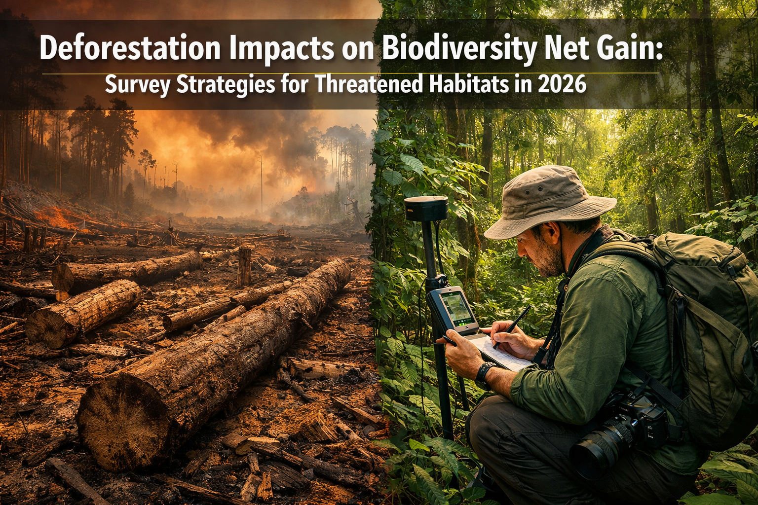
Tropical forest loss accelerated by 14% heading into 2026, with permanent habitat conversions now claiming 34% of primary forest cover worldwide [1]. This alarming trajectory creates unprecedented challenges for professionals tasked with measuring, mitigating, and achieving Biodiversity Net Gain (BNG) targets. As deforestation hotspots expand across the Amazon, Southeast Asia, and Central Africa, survey methodologies must evolve to capture both the scale of ecological debt and the restoration potential required for meaningful conservation outcomes. Understanding Deforestation Impacts on Biodiversity Net Gain: Survey Strategies for Threatened Habitats in 2026 has become essential for developers, ecologists, and policymakers navigating the intersection of habitat loss and regulatory compliance.
The relationship between accelerating forest clearance and BNG compliance represents more than an administrative hurdle—it reflects a fundamental tension between development pressures and ecological integrity. With global biodiversity hotspots having lost more than 85% of original vegetation [3], the baseline conditions against which net gain is measured continue to deteriorate, creating what researchers term a "land use debt" of 29.1 million hectares [3]. This article examines how survey professionals can adapt their assessment frameworks to address these rapidly changing conditions while supporting credible biodiversity net gain outcomes.
Key Takeaways
- Tropical deforestation accelerated 14% into 2026, with agriculture and fires driving permanent habitat loss across critical biodiversity hotspots in South America, Africa, and Asia [1]
- Survey strategies must incorporate dynamic baseline assessments that account for ongoing habitat degradation, using remote sensing and ground-truthing protocols to establish accurate pre-development conditions
- Threatened habitat surveys require specialized protocols including rapid assessment techniques, seasonal timing considerations, and integration with carbon dioxide removal (CDR) project mapping to avoid conflicts
- BNG calculation methodologies need adjustment for degraded landscapes, incorporating habitat condition scoring that reflects deforestation impacts and restoration trajectory modeling
- Case studies from Amazon and Southeast Asian hotspots demonstrate practical approaches to surveying heavily impacted areas while maintaining scientific rigor and regulatory compliance
Understanding Current Deforestation Trends and Their BNG Implications
The 2026 Deforestation Landscape
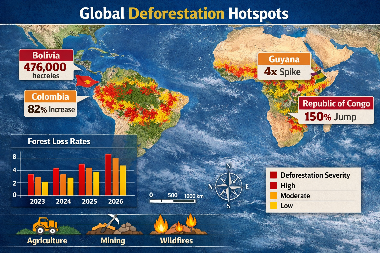
The scale and pace of forest loss in 2026 present sobering realities for conservation professionals. Bolivia's Amazon region logged over 476,000 hectares of primary forest in recent years, driven primarily by gold mining operations and agricultural crop shifts [1]. These activities leave landscapes prone to erosion and waterway contamination, fundamentally altering the ecological baseline against which biodiversity impact assessments must be conducted.
Colombia's "arc of deforestation" experienced an 82% rise in forest loss since 2023, with encroachment threatening Chiribiquete National Park—a UNESCO site containing ancient rock art and endemic plant species [1]. This pattern illustrates how deforestation pressures increasingly target areas of highest conservation value, precisely where BNG interventions could deliver maximum ecological benefit.
Meanwhile, Guyana reports a four-fold spike in primary forest loss, with 60% attributed to wildfires amid drier conditions and 40% to illegal gold mining operations using heavy machinery to bulldoze riverine forests [1]. The Republic of the Congo experienced a 150% jump in forest loss, with fires accounting for 45% of deforestation under hotter, prolonged dry spells [1].
Primary Drivers Reshaping Survey Contexts
Agriculture remains the leading driver of deforestation, accounting for approximately one-third of global tree cover loss [1]. Cattle ranching in Brazil, soy plantations across Latin America, and palm oil expansion in Asia create vast monocultures that eliminate habitat complexity and species diversity. For surveyors, this means baseline assessments increasingly encounter landscapes where original habitat types have been completely replaced, requiring careful consideration of what constitutes a meaningful biodiversity net gain assessment.
Fires now rank close to or surpass agriculture as a deforestation driver in 2024-2026 trends [1], fueled by drought and El Niño effects. Escaped burns from farms ignite vast tracts in the Amazon and Congo basins, creating unpredictable habitat loss patterns that complicate long-term monitoring protocols. Survey strategies must now incorporate fire risk modeling and post-burn recovery assessments into baseline documentation.
The intersection of these drivers creates compounding impacts on biodiversity. Logging roads deepen access for poachers and agricultural conversion [1], while mining operations contaminate water sources that support downstream ecosystems. Understanding these cascading effects becomes crucial when determining appropriate mitigation hierarchies and compensation ratios.
The Land Use Debt Concept
Global biodiversity hotspots now carry a documented "land use debt" of 29.1 million hectares [3], representing habitat that has been degraded but not yet fully accounted for in conservation planning. This concept has profound implications for BNG calculations, as it suggests that even areas appearing intact on satellite imagery may harbor ecological deficits from historical disturbance.
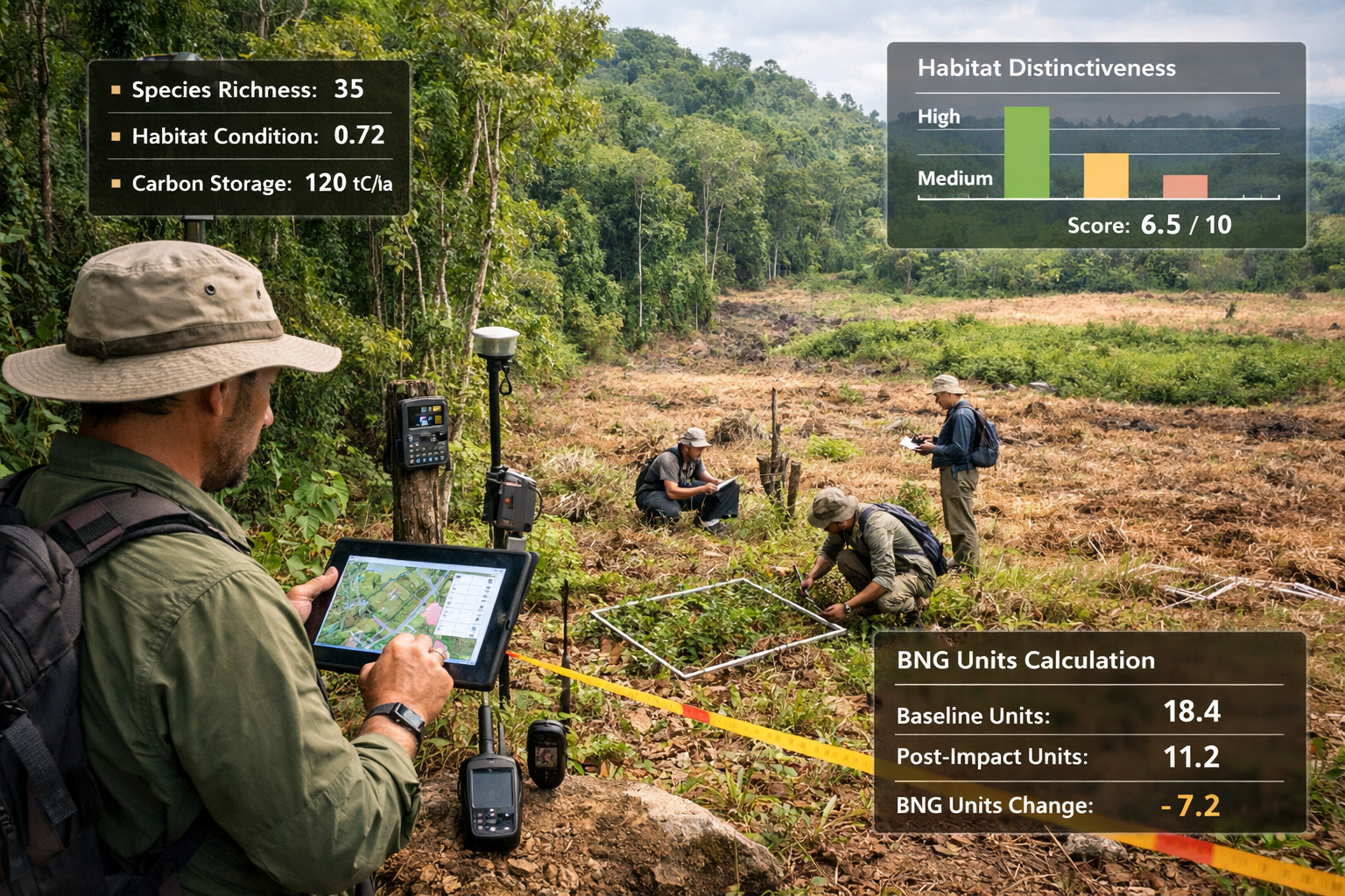
For survey professionals, recognizing land use debt means looking beyond canopy cover to assess habitat functionality—the capacity of an area to support characteristic species assemblages and ecological processes. This requires integrated assessment approaches combining remote sensing with ground-based validation of habitat condition indicators.
Survey Strategies for Threatened Habitats in Deforestation Hotspots
Adapting Baseline Assessment Methodologies
Traditional biodiversity surveys assume relatively stable baseline conditions, but accelerating deforestation demands more dynamic approaches. Rapid baseline deterioration means that assessments conducted even 12-18 months before development may no longer reflect current ecological conditions. Survey protocols must now incorporate:
Multi-temporal remote sensing analysis using satellite imagery to track habitat changes between initial scoping and detailed survey phases. This approach identifies areas experiencing active degradation, allowing surveyors to adjust field sampling strategies accordingly.
Stratified sampling designs that allocate survey effort proportionally across habitat condition gradients. Rather than focusing solely on remaining intact areas, protocols should systematically document degraded zones to establish comprehensive baseline understanding.
Reference site selection criteria that account for regional deforestation patterns. When local reference ecosystems have been eliminated, surveyors must identify appropriate analogs from less-impacted areas or rely on historical ecological data to establish target conditions for restoration.
Specialized Protocols for High-Risk Areas
Surveying in active deforestation zones presents unique challenges requiring adapted methodologies. Safety considerations often limit survey duration and accessibility, necessitating efficient rapid assessment techniques that maximize data quality within constrained timeframes.
Indicator species approaches become particularly valuable in threatened habitats, focusing survey effort on taxa that reliably reflect broader ecosystem health. For tropical forests, this might include:
- 🦜 Bird communities as indicators of canopy integrity and vertical structure
- 🐸 Amphibians reflecting water quality and microhabitat availability
- 🌳 Keystone plant species indicating soil conditions and successional stage
- 🦋 Invertebrate assemblages demonstrating habitat connectivity and resource availability
Seasonal timing considerations gain heightened importance in fire-prone landscapes. Surveys conducted during dry seasons may encounter very different conditions than wet season assessments, affecting species detectability and habitat condition scoring. Protocols should specify optimal survey windows and document seasonal constraints on data interpretation.
Integration with Carbon Dioxide Removal Project Mapping
Approximately 13% of globally important biodiversity-rich land overlaps with carbon dioxide removal (CDR) projects [2], creating potential conflicts between climate mitigation and biodiversity conservation strategies. Survey professionals must now consider how proposed BNG interventions intersect with afforestation and reforestation initiatives.
Spatial planning tools help identify areas where BNG delivery can complement rather than compete with CDR objectives. Research suggests that CDR projects could preserve up to 25% more habitat for biodiversity compared to scenarios without carbon removal [2], but only if ecosystem recovery capacity is carefully assessed.
Conversely, avoiding biodiversity hotspots entirely for CDR projects would reduce land allocation by more than 50% by 2050 [2]. This tension requires survey strategies that:
- Map habitat distinctiveness at landscape scales to identify areas where BNG investments deliver maximum ecological return
- Assess restoration trajectories to determine whether degraded sites can realistically achieve target conditions within 30-year BNG timeframes
- Coordinate with climate initiatives to ensure complementary rather than conflicting land use outcomes
Understanding how architects can solve Biodiversity Net Gain challenges becomes crucial when designing projects that address both carbon and biodiversity objectives.
Calculating BNG in Degraded Landscapes: Methodological Considerations
Habitat Condition Scoring Adjustments
Standard BNG metric calculations assume habitat condition scores reflect relatively stable ecological states. However, in landscapes experiencing active deforestation, condition assessments must account for:
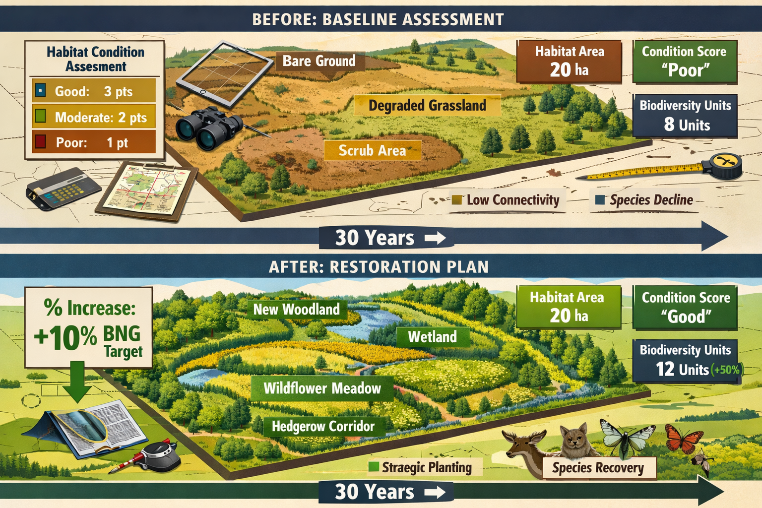
Trajectory analysis that considers whether habitats are improving, stable, or declining. A woodland scoring "moderate" condition but experiencing encroachment from adjacent agricultural clearing represents a different baseline than a similar woodland in a protected landscape.
Edge effects quantification becomes critical in fragmented habitats. Research demonstrates that forest edges experience altered microclimates, invasive species pressure, and reduced specialist species occurrence up to 100 meters from boundaries. Survey protocols should document edge-to-interior ratios and adjust condition scores accordingly.
Functional connectivity assessment recognizes that habitat patches isolated by deforestation may score well on structural attributes but fail to support viable populations or ecological processes. Incorporating connectivity metrics into condition scoring provides more realistic baseline valuations.
Establishing Appropriate Reference Conditions
When original habitat types have been largely eliminated from a region, determining appropriate reference conditions for BNG calculations becomes challenging. Several approaches help address this issue:
Historical ecology reconstruction using archival records, early survey data, and paleoecological evidence to characterize pre-disturbance communities. While resource-intensive, this approach establishes scientifically defensible targets for restoration interventions.
Space-for-time substitution identifies less-impacted areas that approximate historical conditions, using these as reference sites for habitat condition benchmarking. This requires careful consideration of biogeographic and environmental factors that may limit comparability.
Expert elicitation protocols systematically gather knowledge from ecologists familiar with regional ecosystems to establish consensus reference conditions when empirical data are limited. This approach proves particularly valuable for poorly documented habitat types.
Understanding what planners need to know about BNG helps ensure that reference condition selection aligns with regulatory expectations and ecological realities.
Addressing Uncertainty in Restoration Potential
Deforestation impacts often leave landscapes with compromised restoration potential due to soil degradation, altered hydrology, or invasive species establishment. BNG calculations must honestly assess whether proposed compensation sites can realistically achieve target conditions.
Restoration trajectory modeling projects likely ecological outcomes based on:
- Soil condition assessments including nutrient status, compaction, and contamination
- Propagule availability from remnant seed banks or nearby source populations
- Hydrological function including water table depth and seasonal flooding patterns
- Land use history affecting soil biota and ecosystem process recovery rates
Risk-adjusted multipliers should be applied to BNG calculations when restoration success probabilities fall below standard assumptions. If a degraded site has only 70% likelihood of achieving target condition within 30 years, this uncertainty should be reflected in required compensation ratios.
Adaptive management provisions become essential in uncertain restoration contexts. BNG delivery plans should specify monitoring triggers that prompt intervention adjustments if trajectories deviate from projections. This approach aligns with achieving biodiversity net gain without excessive risk.
Case Studies: Survey Approaches in Critical Deforestation Hotspots
Amazon Basin: Rapid Assessment in Dynamic Landscapes
The Amazon's "arc of deforestation" presents extreme challenges for BNG survey work. A 2025 project in Colombia's Caquetá department illustrates adapted methodologies:
Challenge: Development site bordered Chiribiquete National Park buffer zone experiencing 82% increased deforestation rates [1]. Traditional survey protocols requiring multiple seasonal visits proved impractical due to security concerns and rapid baseline changes.
Approach: Survey team implemented compressed assessment protocol combining:
- High-resolution drone imagery (5cm resolution) capturing habitat structure across entire site
- Intensive 14-day ground survey focusing on indicator species groups
- Environmental DNA sampling from water sources to detect cryptic species
- Local ecological knowledge interviews with indigenous communities
Outcomes: Baseline assessment completed in 6 weeks rather than typical 12-18 months. Habitat condition scoring incorporated trajectory analysis showing 15% canopy loss over preceding 24 months, resulting in adjusted baseline valuations. BNG delivery plan prioritized off-site compensation in adjacent protected areas where long-term security could be assured.
Southeast Asian Peatlands: Accounting for Fire Risk
Palm oil expansion across Indonesian and Malaysian peatlands creates recurring fire risk that fundamentally alters BNG calculations. A 2026 Sumatra project demonstrates risk-integrated approaches:
Challenge: Proposed development site in previously logged peatland experienced three major fire events since 2015. Standard habitat condition assessments failed to capture vulnerability to future disturbance.
Approach: Survey incorporated fire risk modeling using:
- Peat depth mapping via ground-penetrating radar
- Hydrological assessments measuring water table depth seasonally
- Analysis of 20-year fire history using MODIS satellite data
- Climate projection downscaling for drought frequency estimates
Outcomes: BNG calculations included fire risk discounting reducing projected biodiversity unit gains by 30% for on-site habitat creation. Compensation strategy shifted toward off-site delivery in fire-resistant habitat types, with financial provisions for active fire management. The approach provided more realistic biodiversity outcome projections than standard protocols.
Central African Forests: Integrating Bushmeat Pressure
Republic of Congo's accelerating deforestation [1] occurs alongside intensive bushmeat hunting that depletes fauna even from structurally intact forests. A 2025 Sangha region project addressed this challenge:
Challenge: Botanical surveys indicated "good" habitat condition, but mammal and bird surveys revealed severely depleted populations of large-bodied species. Standard condition scoring metrics failed to capture faunal defaunation.
Approach: Survey team developed defaunation-adjusted condition scoring incorporating:
- Camera trap arrays documenting presence/absence of 15 indicator mammal species
- Acoustic monitoring quantifying bird community completeness
- Hunter interview surveys estimating offtake rates
- Comparison with protected area reference sites
Outcomes: Condition scores reduced by 20-35% when faunal depletion was incorporated, substantially increasing required compensation ratios. BNG delivery plan included community-based wildlife management agreements alongside habitat restoration, recognizing that achieving net gain requires addressing both habitat and exploitation pressures.
Practical Implementation: Tools and Resources for Survey Professionals
Remote Sensing Platforms and Data Sources
Modern survey strategies increasingly rely on satellite imagery analysis to establish baselines and monitor change. Key platforms include:
Global Forest Watch provides near-real-time deforestation alerts at 10-30m resolution, allowing surveyors to track habitat changes between site visits. Integration with BNG assessment workflows helps identify areas experiencing active degradation.
Sentinel-2 multispectral imagery (10m resolution, 5-day revisit) enables detailed habitat mapping and condition assessment. Normalized Difference Vegetation Index (NDVI) time series reveal vegetation health trends that inform trajectory analysis.
LiDAR datasets where available provide detailed canopy structure information crucial for assessing habitat complexity. Airborne LiDAR captures vertical stratification that ground surveys may miss, particularly in dense tropical forests.
Field Equipment for Rapid Assessment
Compressed survey timelines in threatened habitats require efficient data collection tools:
- Tablet-based survey applications with offline functionality enable real-time data recording and GPS-tagged observations
- Acoustic recording units capture 24-hour soundscapes, maximizing detection of cryptic or nocturnal species
- Camera trap networks document mammal communities with minimal field time investment
- Handheld spectroradiometers assess vegetation health and stress indicators
- Environmental DNA sampling kits detect species presence from water or soil samples
Metric Calculation Tools
Several software platforms support BNG metric calculations adapted for degraded landscapes:
Defra Biodiversity Metric 4.0 (UK-focused) provides standardized calculation framework but requires careful application of condition scoring in deforestation contexts. Surveyors should document adjustments made to account for trajectory and risk factors.
Species-habitat association models help predict biodiversity outcomes under different restoration scenarios. Tools like MaxEnt or Random Forest models can project species occurrence probabilities based on habitat characteristics, informing realistic target-setting.
Connectivity analysis software (e.g., Circuitscape, Linkage Mapper) quantifies landscape permeability and identifies strategic locations for habitat creation that maximize ecological network function.
Regulatory Considerations and Compliance Challenges
Adapting BNG Requirements to Deforestation Contexts
While BNG frameworks originated in relatively stable temperate landscapes, application in deforestation hotspots requires regulatory flexibility. Key considerations include:
Baseline date establishment: Standard protocols specify baseline as date of survey or planning application. In rapidly changing landscapes, regulators may need to accept more recent baseline dates or require updated assessments if significant time elapses before development proceeds.
Compensation ratios: Standard multipliers (e.g., 1.1x for like-for-like habitat replacement) may prove insufficient in landscapes where restoration success is uncertain or where habitat losses contribute to landscape-scale fragmentation. Risk-adjusted ratios of 1.5-2.0x may be more appropriate.
Temporal discounting: BNG metrics typically apply temporal multipliers to account for time lags between habitat loss and compensation delivery. In deforestation hotspots where baseline habitats continue degrading, these multipliers may require adjustment to reflect ongoing ecological debt accumulation.
Understanding why BNG is important helps contextualize these adaptations within broader conservation policy frameworks.
Documentation and Evidence Standards
Regulatory acceptance of BNG assessments in challenged landscapes requires robust documentation:
Photographic evidence with GPS coordinates and timestamps establishes baseline conditions and documents survey methodology. Drone imagery provides valuable context for ground-based observations.
Transparent assumption documentation explicitly states decisions regarding reference conditions, trajectory assessments, and risk adjustments. This transparency allows regulators to evaluate whether professional judgments are scientifically defensible.
Peer review provisions for assessments in particularly complex or high-value habitats provide additional quality assurance. Independent expert review can validate methodological choices and support regulatory confidence.
Long-term Monitoring in Unstable Contexts
BNG delivery requires 30-year monitoring commitments, but deforestation hotspots often experience governance instability and land tenure conflicts. Practical approaches include:
Escrow arrangements that secure monitoring funding independent of project developer continuity. Financial instruments ensure resources remain available even if original parties exit.
Partnership with conservation organizations transfers monitoring responsibilities to entities with long-term presence in region. This approach leverages existing ecological expertise and community relationships.
Remote sensing integration reduces reliance on intensive field visits while maintaining oversight of habitat condition trajectories. Automated change detection algorithms can flag areas requiring ground-truthing.
Future Directions: Evolving Survey Methodologies for 2026 and Beyond
Artificial Intelligence and Machine Learning Applications
Emerging technologies promise to enhance survey efficiency and accuracy in threatened habitats:
Automated species identification from camera trap images and acoustic recordings dramatically increases data processing capacity. Deep learning models now achieve >90% accuracy for many taxonomic groups, allowing surveyors to deploy more extensive monitoring networks.
Predictive habitat modeling using machine learning algorithms can project restoration outcomes with greater precision than traditional approaches. These models incorporate complex interactions between climate, soil, hydrology, and land use history that linear models miss.
Satellite imagery classification powered by convolutional neural networks enables detailed habitat mapping at landscape scales. These tools can distinguish subtle condition gradients that inform baseline assessments and monitoring protocols.
Integrated Climate-Biodiversity Assessment Frameworks
The intersection of climate mitigation and biodiversity conservation demands more holistic assessment approaches. Future survey methodologies should:
Quantify co-benefits of BNG interventions for carbon sequestration, water regulation, and other ecosystem services. Integrated valuation supports strategic site selection that maximizes multiple objectives.
Model climate change impacts on restoration trajectories, recognizing that target conditions may shift as climate envelopes change. Dynamic reference conditions that anticipate future climates provide more realistic restoration targets.
Coordinate with adaptation planning to ensure BNG delivery enhances landscape resilience to climate impacts. Strategic habitat placement can facilitate species range shifts and maintain connectivity under changing conditions.
Strengthening Community Engagement
Effective BNG delivery in deforestation hotspots requires meaningful collaboration with local communities:
Traditional ecological knowledge integration enriches baseline understanding and informs restoration approaches. Indigenous and local communities often possess detailed knowledge of historical ecosystem states and species occurrences.
Benefit-sharing mechanisms ensure that BNG interventions deliver tangible improvements to local livelihoods, building support for long-term conservation outcomes. This might include sustainable resource access rights, employment in restoration activities, or ecotourism revenue sharing.
Participatory monitoring engages communities in data collection, leveraging local presence for cost-effective long-term oversight while building conservation capacity.
Conclusion
Deforestation Impacts on Biodiversity Net Gain: Survey Strategies for Threatened Habitats in 2026 represents one of the most pressing challenges in contemporary conservation practice. With tropical forest loss accelerating by 14% and biodiversity hotspots carrying a 29.1 million hectare "land use debt," survey professionals must fundamentally adapt their methodologies to address rapidly changing baseline conditions, compromised restoration potential, and heightened uncertainty.
The strategies outlined in this article—from dynamic baseline assessment and trajectory analysis to risk-adjusted compensation ratios and integrated climate-biodiversity planning—provide practical frameworks for conducting rigorous surveys in challenging contexts. Case studies from the Amazon, Southeast Asian peatlands, and Central African forests demonstrate that adapted approaches can maintain scientific credibility while acknowledging the realities of working in active deforestation zones.
Actionable Next Steps
For survey professionals and project developers working in threatened habitats:
- Conduct preliminary remote sensing analysis before field surveys to identify areas of active change and optimize sampling strategies
- Incorporate trajectory and risk assessments into habitat condition scoring rather than relying on static measurements
- Establish partnerships with local conservation organizations to support long-term monitoring commitments in unstable contexts
- Document methodological adaptations transparently to support regulatory review and build confidence in assessment conclusions
- Engage with emerging technologies including AI-powered species identification and predictive modeling to enhance survey efficiency
The path to achieving meaningful biodiversity net gain in deforestation hotspots requires acknowledging complexity rather than oversimplifying it. By adopting survey strategies that reflect ecological realities while maintaining scientific rigor, professionals can ensure that BNG frameworks deliver genuine conservation outcomes even in the world's most threatened landscapes. The urgency of 2026's deforestation crisis demands nothing less than this commitment to methodological innovation and ecological integrity.
References
[1] 2026s Alarming Deforestation Surge Hotspots Losing Forests Record Speed – https://www.natureworldnews.com/articles/72721/20260225/2026s-alarming-deforestation-surge-hotspots-losing-forests-record-speed.htm
[2] Climate Or Biodiversity Global Study Maps Out Forestations Dilemma – https://news.mongabay.com/2026/03/climate-or-biodiversity-global-study-maps-out-forestations-dilemma/
[3] 2026 01 Global Terrestrial Biodiversity Hotspots Debt – https://phys.org/news/2026-01-global-terrestrial-biodiversity-hotspots-debt.html
