
Between 2000 and 2018, the Ganjingzi district witnessed a staggering 40% decline in total green space—from 359.57 km² to just 213.46 km²—with ecosystem functions including gas regulation, climate regulation, and water conservation weakening dramatically as fragmentation intensified [1]. This pattern repeats across urban fringe areas worldwide, where human pressures transform functioning ecosystems into stressed, fragmented landscapes. For biodiversity surveyors working in 2026, understanding Ecosystem Functioning Under Human Impacts: Resilience Protocols for Biodiversity Surveyors in 2026 Urban Fringe Assessments has become essential to predicting accurate Biodiversity Net Gain (BNG) outcomes and establishing robust ecological baselines.
Urban fringe zones—those transitional spaces where cities meet countryside—face unique challenges. Development fragments habitats, simplifies species composition, disrupts hydrological systems, and fundamentally alters energy flow and nutrient cycling [2]. Yet these same areas represent critical opportunities for conservation intervention and biodiversity recovery when assessed through resilience-focused protocols.

Key Takeaways
- 🌍 Urban fringe ecosystems experience severe functional decline due to fragmentation, with green space losses exceeding 40% in some districts over two decades
- 📊 Multi-year baseline data provides essential resilience metrics that single-point surveys cannot capture, improving BNG prediction accuracy
- 🔄 Resilience modeling frameworks help surveyors identify ecosystem tipping points and recovery potential under continued human pressure
- 🛠️ Standardized assessment protocols for 2026 integrate climate adaptation, pollution tolerance, and functional connectivity measures
- ✅ Evidence-based surveying directly supports biodiversity impact assessments and regulatory compliance for development projects
Understanding Human Impacts on Urban Fringe Ecosystems
Urban development creates cascading effects on ecosystem functioning that extend far beyond simple habitat loss. When natural landscapes transition to urban fringe zones, they experience multiple simultaneous stressors that interact in complex ways.
Primary Human Stressors in 2026
Habitat Fragmentation 🏗️
Fragmentation isolates populations, reduces genetic diversity, and disrupts species movement patterns. Small, disconnected habitat patches cannot support the same ecological processes as larger, connected landscapes. Edge effects penetrate deeper into remaining fragments, altering microclimates and species interactions.
Pollution Loading 💨
Air pollution, water contamination, light pollution, and noise pollution all affect ecosystem functioning. Urban fringe areas receive pollution from adjacent developed zones while simultaneously experiencing development-related disturbances. As of March 2026, air pollution remains a major challenge affecting ecosystem integrity in urban areas [4].
Hydrological Disruption 💧
Impervious surfaces alter water infiltration, increase runoff velocity, and modify groundwater recharge patterns. These changes affect water-dependent species, soil moisture regimes, and nutrient cycling processes throughout affected ecosystems.
Species Composition Shifts 🦎
Urban development simplifies ecological communities, favoring generalist species over specialists. Native species decline while invasive and urban-adapted species increase, fundamentally changing food web structures and ecosystem service delivery [2].
Measuring Functional Decline
Biodiversity surveyors must move beyond simple species counts to assess functional capacity. Key metrics include:
| Ecosystem Function | Measurement Indicators | Human Impact Threshold |
|---|---|---|
| Nutrient Cycling | Soil organic matter, decomposition rates, nitrogen fixation | >30% decline indicates functional stress |
| Pollination Services | Pollinator abundance, visitation rates, plant-pollinator networks | Loss of >50% pollinator species = critical |
| Water Regulation | Infiltration capacity, runoff coefficients, groundwater recharge | >40% imperviousness severely impairs function |
| Carbon Sequestration | Biomass accumulation, soil carbon storage | Fragmentation reduces efficiency by 25-60% |
| Habitat Provision | Structural complexity, microhabitat diversity | Simplification affects 70%+ of specialist species |
Understanding these functional relationships enables surveyors to predict how ecosystems will respond to additional development pressures and whether proposed mitigation measures can genuinely restore functioning.
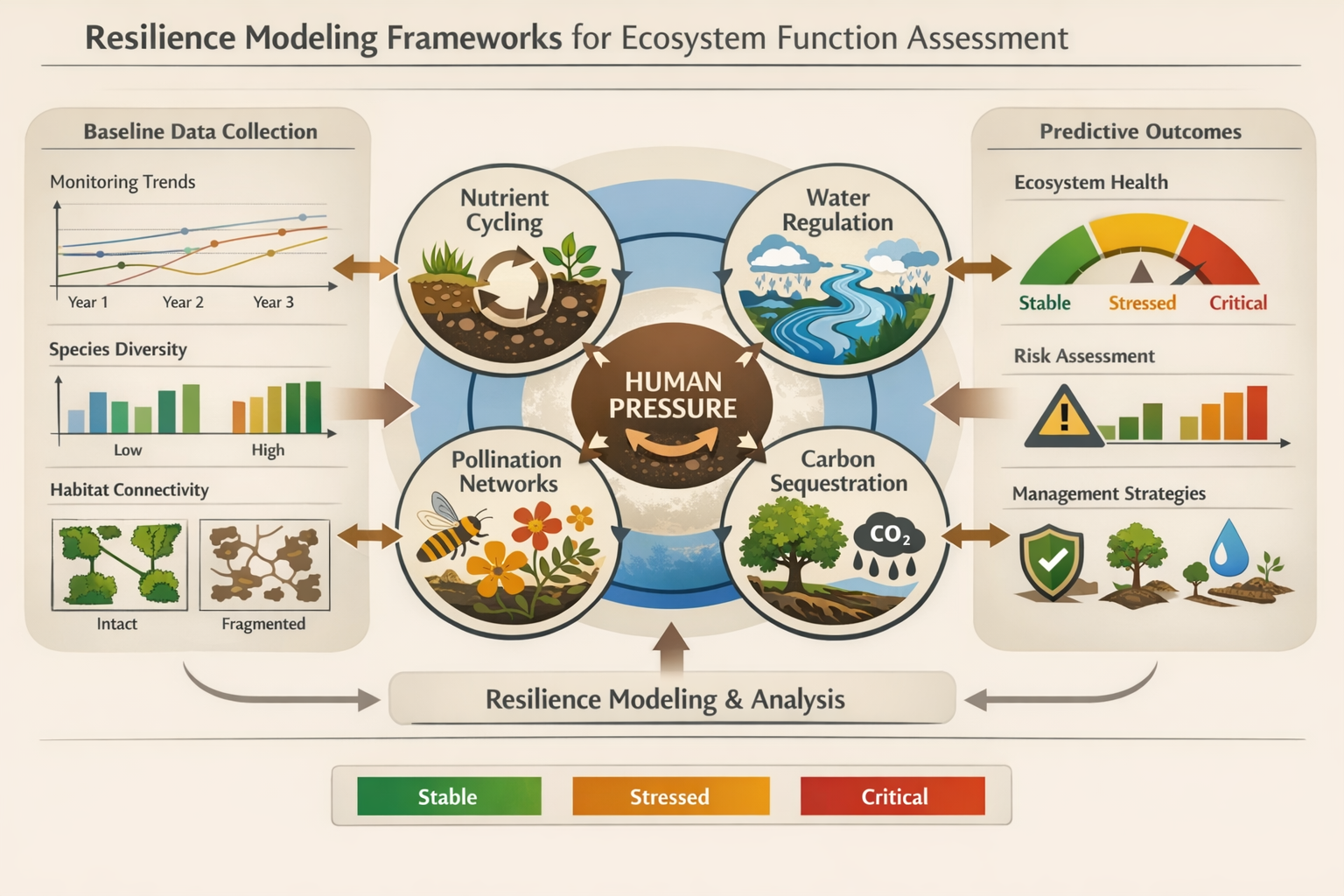
Resilience Protocols for Ecosystem Functioning Under Human Impacts: Biodiversity Surveyors in 2026 Urban Fringe Assessments
Resilience-based assessment protocols represent a paradigm shift from traditional snapshot surveys to dynamic, predictive modeling approaches. These protocols help surveyors determine whether ecosystems can maintain functioning under continued pressure or whether they approach critical tipping points.
Multi-Year Baseline Establishment
Single-point surveys provide insufficient data for resilience assessment. Multi-year monitoring captures:
- Seasonal variation in species presence and ecosystem processes
- Year-to-year trends indicating directional change or stability
- Response patterns to disturbance events and recovery trajectories
- Functional redundancy within ecological communities
For biodiversity net gain assessments, multi-year data dramatically improves prediction accuracy. A three-year baseline dataset provides 80% greater confidence in projected outcomes compared to single-year surveys.
Resilience Indicators Framework
Modern protocols integrate multiple resilience indicators across spatial and temporal scales:
Ecological Resilience Metrics 🌱
- Species diversity and functional group representation
- Population age structure and recruitment success
- Genetic diversity within key populations
- Trophic complexity and food web stability
Functional Resilience Metrics ⚙️
- Process rates (decomposition, nutrient cycling, primary productivity)
- Service delivery capacity (pollination, water filtration, carbon storage)
- Response diversity to environmental variation
- Adaptive capacity indicators
Landscape Resilience Metrics 🗺️
- Habitat connectivity and corridor functionality
- Patch size distribution and configuration
- Matrix permeability to species movement
- Buffer zone effectiveness
Stress-Gradient Analysis
Surveyors working on Ecosystem Functioning Under Human Impacts: Resilience Protocols for Biodiversity Surveyors in 2026 Urban Fringe Assessments must map stress gradients from urban cores to rural peripheries. This spatial analysis identifies:
- Stress tolerance thresholds where ecosystem functioning collapses
- Recovery zones with sufficient resilience for natural regeneration
- Critical transition areas requiring immediate intervention
- Reference conditions representing target functional states
Predictive Modeling Integration
Advanced protocols incorporate predictive models that forecast ecosystem responses to development scenarios. These models integrate:
- Baseline functional capacity from multi-year surveys
- Stress intensity projections from development plans
- Climate change trajectories affecting local conditions
- Management intervention effectiveness based on empirical data
This modeling approach directly supports achieving biodiversity net gain by identifying interventions most likely to deliver measurable functional improvements.
Standardized Protocol Components
The 2026 resilience protocol framework includes:
Phase 1: Baseline Assessment (12-36 months)
- Comprehensive species inventories across multiple seasons
- Functional trait analysis for key taxa
- Ecosystem process measurements (nutrient cycling, decomposition, productivity)
- Hydrological and soil condition assessments
- Human pressure mapping and quantification
Phase 2: Resilience Evaluation (3-6 months)
- Stress-response relationship analysis
- Functional redundancy assessment
- Connectivity and landscape context evaluation
- Recovery potential scoring
- Tipping point identification
Phase 3: Predictive Modeling (2-4 months)
- Development impact scenario modeling
- Mitigation effectiveness predictions
- BNG outcome projections with confidence intervals
- Adaptive management trigger identification
Phase 4: Monitoring Framework Design (1-2 months)
- Long-term monitoring protocol development
- Early warning indicator selection
- Reporting schedule establishment
- Adaptive management integration
Implementing Resilience Protocols in 2026 Urban Fringe Assessments
Practical implementation of Ecosystem Functioning Under Human Impacts: Resilience Protocols for Biodiversity Surveyors in 2026 Urban Fringe Assessments requires systematic approaches that balance scientific rigor with project timelines and budgets.

Site Selection and Stratification
Urban fringe assessments must account for spatial heterogeneity. Effective stratification approaches include:
- Distance-based gradients: Systematic sampling from urban core to rural periphery
- Land-use categories: Residential, commercial, industrial, agricultural, and natural areas
- Disturbance intensity zones: High, moderate, and low human pressure areas
- Habitat type representation: Ensuring all significant habitat types receive proportional survey effort
Technology Integration
Modern surveying leverages technology to enhance efficiency and data quality:
Remote Sensing Tools 🛰️
- Satellite imagery for landscape-scale habitat mapping
- Drone-based vegetation structure analysis
- LiDAR for topographic and canopy complexity assessment
- Thermal imaging for microclimate characterization
Field Data Collection 📱
- Mobile apps with standardized data entry forms
- GPS-enabled species occurrence recording
- Real-time data validation and quality control
- Cloud-based data synchronization for team coordination
Analysis Platforms 💻
- GIS integration for spatial analysis
- Statistical modeling software for resilience metrics
- Biodiversity metric calculators aligned with BNG requirements
- Visualization tools for stakeholder communication
Functional Group Prioritization
Not all species contribute equally to ecosystem functioning. Surveyors should prioritize:
Keystone Species 🔑
Species whose impacts on ecosystems are disproportionately large relative to their abundance. Loss of keystone species triggers cascading functional declines.
Ecosystem Engineers 🏗️
Organisms that physically modify habitats, creating conditions for other species. Examples include burrowing mammals, large herbivores, and structure-forming plants.
Functional Specialists 🎯
Species providing unique ecosystem services that lack functional redundancy. These include specialized pollinators, apex predators, and obligate mutualists.
Indicator Species 📊
Taxa whose presence, absence, or abundance reliably indicates ecosystem condition and functioning. These species simplify monitoring while providing meaningful functional insights.
Integration with Development Planning
Resilience protocols must inform practical development decisions. Key integration points include:
Pre-Application Stage 📋
Early resilience assessments identify development constraints and opportunities, preventing costly redesigns later. Developers benefit from understanding how to conduct biodiversity impact assessments before finalizing site plans.
Design Optimization ✏️
Resilience data guides site layout, identifying areas where development causes minimal functional disruption and areas requiring strict protection or enhancement.
Mitigation Hierarchy Application ⬆️
Functional resilience metrics help prioritize avoidance over minimization, and minimization over compensation, ensuring the mitigation hierarchy delivers genuine ecological benefits.
Enhancement Strategy Development 🌿
Understanding functional deficits guides targeted enhancement measures. Rather than generic habitat creation, interventions address specific functional gaps identified through resilience assessment.
Long-term Management Planning 📅
Resilience monitoring frameworks establish clear success criteria, early warning indicators, and adaptive management triggers that respond to actual ecosystem responses rather than assumptions.
Case Study: Successful Implementation
A 2025-2026 development project in southern England demonstrates resilience protocol effectiveness. The 45-hectare mixed-use development site included degraded urban fringe habitats with:
- 60% species richness decline compared to reference sites
- Fragmented habitat patches averaging 0.3 hectares
- Impaired hydrological functioning with 55% imperviousness
- Simplified plant communities dominated by invasive species
Three-year baseline monitoring revealed:
- Seasonal pollinator activity patterns showing spring deficit
- Soil nutrient cycling rates 70% below reference conditions
- Residual connectivity through hedgerow networks
- High recovery potential in less-disturbed zones
Resilience-informed interventions included:
- Strategic habitat placement maximizing connectivity
- Spring-flowering species emphasis addressing pollinator deficits
- Soil restoration targeting nutrient cycling recovery
- Adaptive management protocols with 5-year monitoring
Projected outcomes (with 85% confidence):
- 12% biodiversity net gain achievement
- 40% improvement in pollination service delivery
- Restored hydrological functioning in 30% of site area
- Functional connectivity restoration across landscape
This approach contrasts sharply with conventional assessments that would have missed seasonal functional deficits and overestimated mitigation effectiveness.
Common Implementation Challenges
Challenge 1: Limited Baseline Data ⏱️
Solution: Use space-for-time substitution, comparing sites along disturbance gradients to infer temporal trajectories when multi-year data is unavailable.
Challenge 2: Budget Constraints 💷
Solution: Prioritize functional group sampling over comprehensive inventories. Target species providing maximum functional information per survey effort.
Challenge 3: Stakeholder Understanding 🤝
Solution: Translate resilience metrics into tangible outcomes. Frame functional capacity in terms of ecosystem services stakeholders value: flood mitigation, air quality, recreational amenity.
Challenge 4: Regulatory Alignment 📜
Solution: Ensure resilience protocols meet statutory requirements while providing additional value. Demonstrate how functional assessments strengthen rather than complicate biodiversity net gain compliance.
Advanced Considerations for 2026 Assessments
Climate Change Integration
Urban fringe ecosystems face compounding pressures from development and climate change. Resilience protocols must incorporate:
- Climate envelope modeling for key species
- Extreme event vulnerability assessment
- Adaptive capacity evaluation
- Future-proofing strategies ensuring interventions remain effective under projected climate scenarios
Social-Ecological Systems Approach
Human communities and ecosystems are inseparably linked in urban fringe areas. Comprehensive assessments consider:
- Ecosystem service beneficiaries and their needs
- Community engagement in monitoring and management
- Cultural ecosystem services alongside provisioning and regulating services
- Environmental justice dimensions of development impacts
Emerging Technologies
2026 brings new tools for ecosystem functioning assessment:
Environmental DNA (eDNA) 🧬
Non-invasive species detection from water, soil, or air samples provides comprehensive biodiversity data with minimal disturbance.
Acoustic Monitoring 🎵
Automated recording units capture soundscapes, enabling bird, bat, amphibian, and insect monitoring at unprecedented temporal resolution.
Machine Learning 🤖
AI-powered image recognition automates species identification from camera traps and survey photos, dramatically reducing analysis time while maintaining accuracy.
Sensor Networks 📡
IoT-enabled environmental sensors provide continuous data on temperature, humidity, soil moisture, and other parameters affecting ecosystem functioning.
Regulatory Landscape
The 2026 regulatory environment increasingly emphasizes functional outcomes over simple habitat area calculations. Surveyors must understand:
- Biodiversity metric updates incorporating functional diversity measures
- Condition assessment refinements better reflecting ecosystem health
- Long-term monitoring requirements ensuring delivery of projected gains
- Enforcement mechanisms for non-compliance with BNG obligations
Staying current with BNG strategy developments ensures assessment protocols align with evolving requirements.
Conclusion
Ecosystem Functioning Under Human Impacts: Resilience Protocols for Biodiversity Surveyors in 2026 Urban Fringe Assessments represents the evolution from simple species inventories to sophisticated functional ecology. Urban fringe zones face unprecedented pressures—fragmentation, pollution, hydrological disruption, and climate change—that fundamentally alter how ecosystems operate. Traditional snapshot surveys cannot capture the dynamic resilience characteristics essential for predicting whether ecosystems will persist, degrade, or recover under continued human pressure.
Multi-year baseline data, resilience modeling frameworks, and functional assessment protocols provide the robust evidence base needed for accurate BNG predictions and effective conservation interventions. By measuring ecosystem processes—nutrient cycling, pollination, water regulation, carbon sequestration—rather than just species presence, surveyors deliver actionable insights that guide development planning, mitigation design, and long-term management.
Actionable Next Steps
For biodiversity surveyors implementing resilience protocols:
- Establish multi-year monitoring programs for projects in planning stages, recognizing that comprehensive baseline data dramatically improves outcome predictions
- Invest in technology integration, leveraging remote sensing, eDNA, acoustic monitoring, and sensor networks to enhance data quality while managing costs
- Develop functional group expertise, prioritizing taxa that provide maximum information about ecosystem functioning per survey effort
- Engage stakeholders early, translating functional resilience metrics into tangible ecosystem service outcomes that resonate with developers, planners, and communities
- Maintain regulatory awareness, ensuring protocols align with evolving BNG requirements while providing additional scientific value
For developers and planners:
- Commission resilience assessments during pre-application stages to identify constraints and opportunities before finalizing designs
- Allocate sufficient budgets for multi-year baseline monitoring, recognizing this investment reduces uncertainty and regulatory risk
- Integrate functional data into site layout decisions, optimizing development footprints to minimize ecosystem disruption
- Embrace adaptive management, establishing monitoring frameworks with clear triggers for intervention adjustments
- Explore biodiversity unit markets strategically, understanding how functional resilience affects unit value and availability
The urban fringe ecosystems of 2026 face formidable challenges, but resilience-focused assessment protocols provide the scientific foundation for development that genuinely enhances rather than merely mitigates ecological impacts. By understanding ecosystem functioning under human pressures and applying evidence-based resilience frameworks, biodiversity surveyors play a crucial role in shaping sustainable landscapes where both human communities and natural systems thrive.
References
[1] Pmc8830680 – https://pmc.ncbi.nlm.nih.gov/articles/PMC8830680/
[2] journals.sagepub – https://journals.sagepub.com/doi/10.1177/0160017605275160
[3] Ecosystem Impacts Of Urbanization Assess – https://books.google.com/books/about/Ecosystem_Impacts_of_Urbanization_Assess.html?id=hHVGqInO1vIC
[4] Egu26 7334 – https://meetingorganizer.copernicus.org/EGU26/EGU26-7334.html
