
A recent analysis revealed that over 40% of corporate rewilding projects report ecosystem recovery metrics that cannot be verified through independent field surveys. As artificial intelligence models promise to predict biodiversity outcomes with unprecedented accuracy, the gap between algorithmic optimism and muddy boots reality has never been wider. This disconnect matters profoundly in 2026, as Biodiversity Net Gain (BNG) requirements force developers and landowners to prove genuine ecological recovery rather than simply model it.
The Rewilding Reality Check: Surveyor Tools to Measure True Ecosystem Recovery Beyond AI Predictions in 2026 represents a critical shift in how restoration success is validated. While machine learning algorithms can process satellite imagery and predict habitat suitability, they cannot capture the nuanced indicators that professional surveyors document in the field—from soil invertebrate communities to mycorrhizal networks that signal true ecosystem function.
Key Takeaways
- Ground-truthed field surveys remain essential for validating AI predictions of rewilding success, with manual species counts and habitat assessments providing irreplaceable data quality
- Modern surveyor toolkits combine traditional methods with technology, including eDNA sampling, acoustic monitoring, and drone surveys to measure ecosystem recovery comprehensively
- Corporate BNG reporting requires verified metrics beyond modeled predictions, with independent biodiversity impact assessments providing accountability
- Ecosystem recovery timelines often diverge from AI forecasts, with real-world factors like soil legacy effects and dispersal limitations creating unpredictable outcomes
- Standardized monitoring protocols developed in 2026 help bridge the gap between predictive models and measurable field results for regulatory compliance
The AI Prediction Problem: Why Algorithms Overestimate Rewilding Success
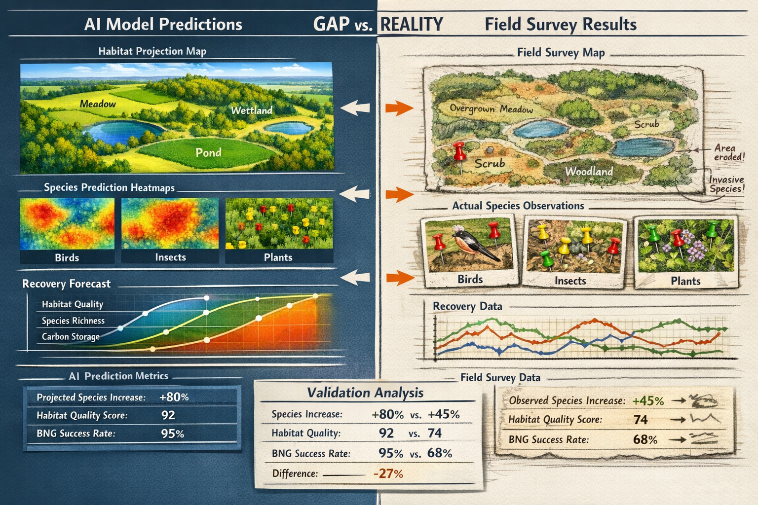
Artificial intelligence has revolutionized ecological modeling, offering developers and conservation organizations the ability to forecast biodiversity outcomes before breaking ground. These sophisticated systems analyze historical data, satellite imagery, climate variables, and species distribution models to predict how ecosystems will respond to rewilding interventions.
The problem? AI models consistently overestimate recovery rates because they operate in a sanitized digital environment that lacks the messy complications of real-world ecology.
What AI Models Miss in Ecosystem Recovery
Machine learning algorithms excel at pattern recognition but struggle with the chaotic variables that define actual habitat restoration:
🌱 Soil legacy effects – Decades of agricultural chemicals, compaction, and depleted organic matter create invisible barriers to recovery that satellite imagery cannot detect
🦋 Dispersal limitations – AI assumes species will colonize suitable habitat, but fragmented landscapes prevent many organisms from reaching restoration sites
🔬 Microbial communities – The foundation of ecosystem function exists below ground, where algorithms have virtually no data to analyze
🌦️ Extreme weather events – Climate volatility introduces unpredictable setbacks that historical models cannot anticipate
Research highlighted for World Rewilding Day 2026 demonstrates that ecosystems can indeed rebound faster than expected when pressures are removed, with secondary forests recovering substantial biodiversity within decades and marine reserves showing rapid fish population recovery.[2] However, these observational findings represent best-case scenarios under optimal conditions—not the contaminated brownfield sites or degraded agricultural land that most BNG projects actually work with.
The Corporate Reporting Dilemma
Organizations investing in rewilding face intense pressure to demonstrate environmental credentials. AI predictions offer an attractive solution: impressive biodiversity forecasts generated quickly and cost-effectively. But regulatory frameworks in 2026 increasingly demand verification through independent field surveys.
The Scottish rewilding community guide emphasizes that effective projects need "a way to track your progress so you can monitor change over the years,"[1] acknowledging that long-term monitoring—not one-time predictions—determines genuine success.
For developers navigating Biodiversity Net Gain requirements, the stakes are particularly high. Planning authorities now scrutinize the methodology behind biodiversity unit calculations, rejecting applications that rely solely on modeled outcomes without field validation protocols.
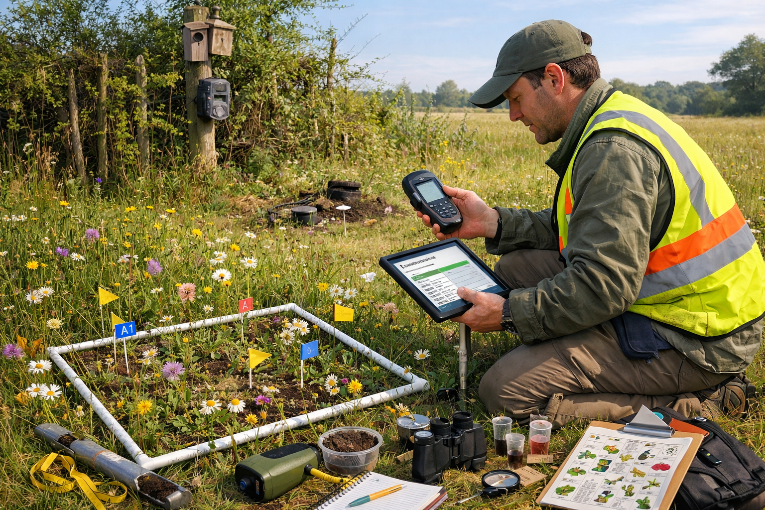
Surveyor Tools for the Rewilding Reality Check in 2026
Professional ecological surveyors employ a sophisticated toolkit that combines traditional field methods with cutting-edge technology. This integrated approach provides the ground-truthed data necessary to validate—or contradict—AI predictions about ecosystem recovery.
Traditional Assessment Methods That Still Matter
Despite technological advances, certain foundational surveying techniques remain irreplaceable for measuring true ecosystem recovery:
Vegetation Quadrat Sampling 📏
Systematic sampling using fixed-area frames allows surveyors to document species composition, abundance, and structural diversity. This labor-intensive method captures botanical detail that remote sensing simply cannot match, particularly for understory species and ground flora critical to biodiversity assessments.
Point Count Bird Surveys 🐦
Trained ornithologists conduct timed observation periods at standardized locations, recording all bird species detected visually and acoustically. These surveys reveal breeding populations and habitat use patterns that indicate ecosystem maturity.
Invertebrate Sampling 🦗
Pitfall traps, sweep netting, and targeted searches for indicator species provide essential data about ecosystem function. Invertebrate communities respond rapidly to habitat changes and serve as sensitive indicators of recovery quality.
Soil Analysis 🌍
Physical and chemical soil testing, combined with biological assessments of earthworm populations and microbial activity, reveals the foundational health that supports all other biodiversity.
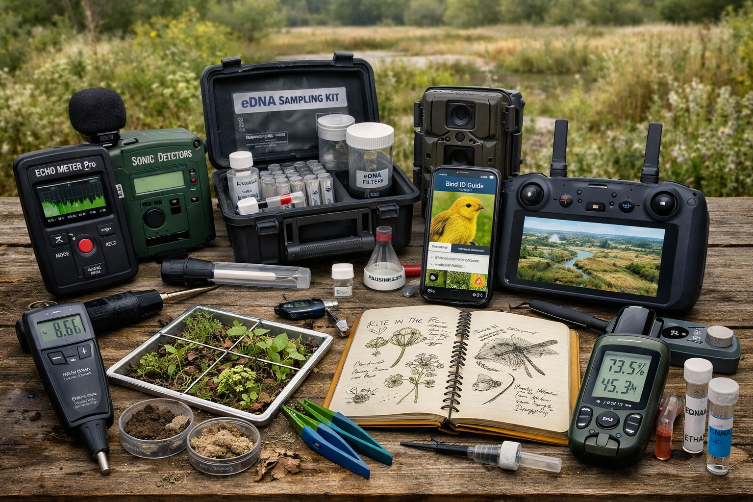
Modern Technology Integration
Contemporary surveyors augment traditional methods with technology that extends their capabilities:
| Technology | Application | Advantage Over AI Alone |
|---|---|---|
| Environmental DNA (eDNA) | Water and soil samples analyzed for genetic material | Detects cryptic species and validates predicted species presence |
| Acoustic Monitoring | Autonomous recorders capture bat, bird, and amphibian calls | Provides temporal data across seasons that single surveys miss |
| Drone Surveys | High-resolution aerial imagery and LiDAR mapping | Ground-truths habitat extent and structure at site scale |
| Camera Traps | Motion-activated wildlife photography | Documents mammal populations and behavior patterns |
| Smartphone Apps | Digital data collection with GPS tagging | Ensures data quality and real-time validation |
These tools don't replace human expertise—they amplify it. A surveyor using eDNA sampling still requires taxonomic knowledge to interpret results and understand ecological context. Drone imagery needs ground-truthing through physical site visits to verify habitat classifications.
Protocols for Validating Rewilding Success
Standardized monitoring protocols developed in 2026 help bridge the gap between AI predictions and measurable outcomes. These frameworks establish:
✅ Baseline surveys conducted before rewilding interventions begin, documenting starting conditions comprehensively
✅ Temporal monitoring schedules with surveys repeated at 1, 3, 5, and 10-year intervals to track recovery trajectories
✅ Control site comparisons where nearby reference ecosystems provide benchmarks for expected biodiversity
✅ Multi-taxa approaches that assess plants, birds, invertebrates, and mammals rather than single indicator groups
✅ Functional diversity metrics measuring ecosystem services like pollination, seed dispersal, and nutrient cycling
Professional biodiversity surveyors implement these protocols systematically, generating defensible data that withstands regulatory scrutiny and provides genuine accountability for corporate environmental commitments.
Implementing Rewilding Reality Checks for BNG Compliance
For developers, landowners, and conservation organizations working within the UK's Biodiversity Net Gain framework, implementing robust reality checks requires strategic planning and appropriate resource allocation.
Designing Monitoring Programs That Satisfy Regulators
Regulatory authorities in 2026 have become increasingly sophisticated in evaluating BNG monitoring proposals. Successful programs incorporate:
Clear Success Criteria 🎯
Define measurable targets for species richness, habitat condition scores, and structural diversity that align with habitat creation or enhancement goals. Vague aspirations like "increased biodiversity" no longer satisfy planning conditions.
Independent Verification ✓
Engage professional ecological consultants who are independent from the development team to conduct monitoring and report results objectively. This separation ensures credibility and prevents conflicts of interest.
Adaptive Management Triggers 🔄
Establish threshold conditions that trigger management interventions if recovery trajectories fall short of predictions. This demonstrates commitment to genuine outcomes rather than passive hope.
Long-term Funding Security 💰
BNG obligations extend for 30 years, requiring financial mechanisms that ensure monitoring continues regardless of site ownership changes or organizational restructuring.
Cost-Benefit Analysis: AI Predictions vs. Field Surveys
Organizations often question whether comprehensive field surveys justify their cost compared to algorithm-based assessments. The 2026 reality reveals a more nuanced calculation:
Upfront Costs:
- AI modeling: £2,000-5,000 per site
- Comprehensive baseline survey: £8,000-15,000
- Annual monitoring surveys: £3,000-6,000
Hidden Costs of AI-Only Approaches:
- Planning application rejections requiring expensive resubmissions
- Failure to achieve predicted outcomes triggering penalty clauses
- Reputational damage from unverified environmental claims
- Potential legal liability for misrepresented biodiversity gains
The Scottish community guide emphasizes that tracking progress over years[1] represents an investment in genuine conservation outcomes rather than an optional expense. For developers seeking to achieve 10% biodiversity net gain, field-validated monitoring provides the evidence needed to demonstrate compliance and avoid enforcement action.
Integrating AI and Field Surveys Effectively
The optimal approach in 2026 doesn't abandon AI predictions—it uses them strategically within a framework of ground-truthed validation:
1. Pre-intervention Modeling 🖥️
Use AI to explore design scenarios and predict outcomes, informing habitat placement and species-specific interventions during the planning phase.
2. Baseline Field Surveys 📋
Conduct comprehensive professional surveys to document actual starting conditions, calibrating AI models with real data.
3. Predictive Refinement 🔧
Adjust algorithmic predictions based on site-specific constraints identified during baseline surveys, creating more realistic forecasts.
4. Monitoring Implementation 👥
Execute field surveys at scheduled intervals using standardized protocols, collecting data that tests AI predictions.
5. Model Validation and Learning 📊
Compare predicted versus actual outcomes, identifying systematic biases in algorithms and improving future modeling accuracy.
This integrated workflow leverages the efficiency of AI while maintaining the accountability that only field verification provides. Organizations adopting this approach report higher success rates in achieving biodiversity net gain targets and smoother regulatory approval processes.
Case Study Insights: Where Predictions Met Reality
Early 2026 data from BNG sites across England reveals instructive patterns:
Grassland Creation Projects showed the largest divergence between AI predictions and field results. Algorithms consistently overestimated species-rich grassland establishment by 18-24 months, underestimating the time required for soil conditioning and appropriate species colonization.
Woodland Planting Schemes performed closer to predictions when surveyors verified appropriate species selection and planting techniques. However, mammal browsing pressure—difficult for AI to predict—significantly impacted establishment success at 30% of sites.
Wetland Restoration exceeded AI predictions at sites where hydrological surveys preceded intervention design. Ground-truthed understanding of water flow patterns proved more valuable than algorithmic modeling of topography alone.
These patterns underscore the importance of professional biodiversity impact assessments that combine predictive modeling with expert field judgment and ongoing monitoring.
The Future of Ecosystem Recovery Measurement
As rewilding initiatives scale globally and regulatory frameworks mature, the relationship between AI predictions and field validation continues evolving. The lesson of 2026 is clear: technology enhances but cannot replace the irreplaceable value of trained ecological surveyors documenting actual ecosystem recovery.
Research published in 2026 emphasizes that restoring nature requires restoring trust—and trust demands transparency about what is actually happening on the ground, not just what models predict should happen.[5] For organizations committed to genuine environmental stewardship rather than greenwashing, this reality check represents an opportunity rather than a burden.
The most successful rewilding projects embrace measurement rigor as a competitive advantage. They recognize that verified ecological recovery:
- Strengthens corporate sustainability credentials with stakeholder audiences
- Reduces regulatory risk and accelerates planning approvals
- Generates valuable data that improves future conservation effectiveness
- Contributes to broader scientific understanding of ecosystem restoration
For professionals navigating BNG requirements for small development projects or large-scale habitat creation schemes, investing in comprehensive monitoring represents prudent risk management and ethical responsibility.
Conclusion
The Rewilding Reality Check: Surveyor Tools to Measure True Ecosystem Recovery Beyond AI Predictions in 2026 challenges the seductive simplicity of algorithmic forecasting with the complex, messy, and ultimately more rewarding reality of genuine ecological restoration. While artificial intelligence offers valuable planning insights, only systematic field surveys conducted by professional ecologists can verify whether rewilding initiatives deliver promised biodiversity outcomes.
For developers, landowners, and conservation organizations, the path forward combines technological efficiency with methodological rigor. AI models inform initial design and establish testable hypotheses. Professional surveyors provide the ground-truthed data that validates predictions, identifies problems early, and demonstrates regulatory compliance.
Actionable Next Steps
For Developers and Landowners:
- Commission comprehensive baseline biodiversity surveys before finalizing habitat creation designs
- Establish long-term monitoring contracts with independent ecological consultants
- Build adaptive management provisions into BNG plans that respond to monitoring findings
- Budget realistically for 30-year monitoring obligations rather than treating them as afterthoughts
For Conservation Professionals:
- Develop standardized protocols that integrate traditional survey methods with emerging technologies
- Advocate for regulatory frameworks that require field validation of AI predictions
- Build capacity in emerging techniques like eDNA analysis and acoustic monitoring
- Document and publish comparisons between predicted and actual outcomes to improve modeling accuracy
For Planning Authorities:
- Scrutinize monitoring proposals to ensure they provide genuine accountability
- Require independent verification of biodiversity outcomes at key milestones
- Establish clear enforcement mechanisms when sites fail to achieve predicted gains
- Support data sharing initiatives that improve collective understanding of restoration success factors
The rewilding movement stands at a critical juncture. The tools exist to measure genuine ecosystem recovery with unprecedented precision. The regulatory framework demands verified outcomes rather than optimistic projections. The question is whether organizations will embrace this reality check as an opportunity to demonstrate authentic environmental leadership—or continue chasing algorithmic predictions that may never materialize in the field.
For those ready to commit to measurable, verifiable biodiversity gains, professional surveyor partnerships provide the expertise and accountability that transforms rewilding ambitions into documented ecological recovery.
References
[1] Community Rewilding Guide – https://www.rewild.scot/publication/community-rewilding-guide/
[2] World Rewilding Day 2026 Choosing A Future That Puts Nature First – https://www.earth.com/news/world-rewilding-day-2026-choosing-a-future-that-puts-nature-first/
[3] World Rewilding Day 2026 Choose Our Future – https://www.decadeonrestoration.org/world-rewilding-day-2026-choose-our-future
[4] Pan3 – https://besjournals.onlinelibrary.wiley.com/doi/full/10.1002/pan3.70100
[5] Restoring Nature Restoring Trust Why People Matter In Nature Recovery – https://globalrewilding.earth/restoring-nature-restoring-trust-why-people-matter-in-nature-recovery/
[6] Watch – https://www.youtube.com/watch?v=WwKJqPfVLNw
