
Habitat fragmentation now affects 70% of the world's remaining forests, with the average distance between forest patches decreasing species survival rates by up to 50% in some regions. As development pressures intensify across the UK and globally, biodiversity surveyors face a critical challenge: traditional site-based assessments no longer capture the landscape-level connectivity that determines whether species can survive, reproduce, and adapt to environmental change. Ecosystem Connectivity in Biodiversity Surveys: Mapping Species Movement Across Fragmented Habitats for 2026 Net Gain Projects represents a fundamental shift from isolated habitat evaluation toward integrated corridor mapping that reflects how wildlife actually moves through fragmented landscapes.
This evolution in survey methodology arrives at a pivotal moment. With the UK's mandatory Biodiversity Net Gain (BNG) requirements now fully operational and international frameworks like the Kunming-Montreal Global Biodiversity Framework emphasizing connectivity, developers and ecologists must adopt survey approaches that measure not just habitat quality within project boundaries, but the functional connections that sustain viable populations across entire landscapes.
Key Takeaways
- Connectivity metrics now include multiple harmonized indicators such as Forest Area Density, Natural Area Connectivity, and LARCH-SCAN models that assess both structural and functional landscape connections [2]
- Survey frameworks must shift from site-specific assessments to landscape-level mapping that captures species movement corridors, dispersal routes, and migration pathways across fragmented habitats
- Emerging technologies including Tiny Machine Learning (TinyML) and optical AI chips enable real-time biodiversity detection in remote areas without internet connectivity, strengthening evidence for connectivity mapping [3]
- International research initiatives like BiodivConnect prioritize ecosystem connectivity restoration with submission deadlines in April 2026, supporting innovative approaches to measuring and enhancing habitat connections [1]
- 2026 Net Gain projects require integrated connectivity planning that links on-site habitat creation with off-site corridor enhancement to achieve measurable improvements in landscape-scale biodiversity outcomes
Understanding Ecosystem Connectivity in Modern Biodiversity Surveys
Ecosystem connectivity refers to the degree to which landscapes facilitate or impede movement of organisms, genes, and ecological processes between habitat patches. Unlike traditional biodiversity surveys that assess species presence and habitat quality within defined boundaries, connectivity-focused surveys examine the functional relationships between habitat fragments across entire landscapes.
The Shift from Site-Based to Landscape-Level Assessment
Conventional biodiversity surveys typically document species inventories, habitat condition, and ecological value within project sites. While this approach satisfies basic regulatory requirements, it fails to address a fundamental ecological reality: most species require access to multiple habitat patches throughout their life cycles. A woodland survey might identify excellent habitat quality, but if that woodland is isolated by 5 kilometers of intensive agriculture with no connecting hedgerows, its long-term conservation value diminishes significantly.
The 2026 global horizon scan identifies 15 emerging issues for biodiversity conservation, including soil moisture decline and habitat loss that directly impact connectivity corridors [3]. These threats operate at landscape scales, making site-specific mitigation insufficient without broader connectivity planning.
Why Connectivity Matters for Net Gain Projects
Biodiversity Net Gain requirements mandate that development projects deliver measurable improvements in biodiversity value. However, creating isolated habitat patches—no matter how high quality—cannot substitute for functional ecological networks. Species need:
🔹 Dispersal corridors for juvenile animals seeking new territories
🔹 Migration routes for seasonal movements between breeding and feeding grounds
🔹 Gene flow pathways to maintain genetic diversity and population viability
🔹 Climate adaptation corridors enabling species to shift ranges as conditions change
When planning biodiversity net gain projects, connectivity assessment ensures that habitat creation contributes to landscape-scale ecological function rather than producing isolated "islands" that cannot sustain viable populations over time.
Connectivity Assessment Methods for Ecosystem Connectivity in Biodiversity Surveys: Mapping Species Movement Across Fragmented Habitats for 2026 Net Gain Projects
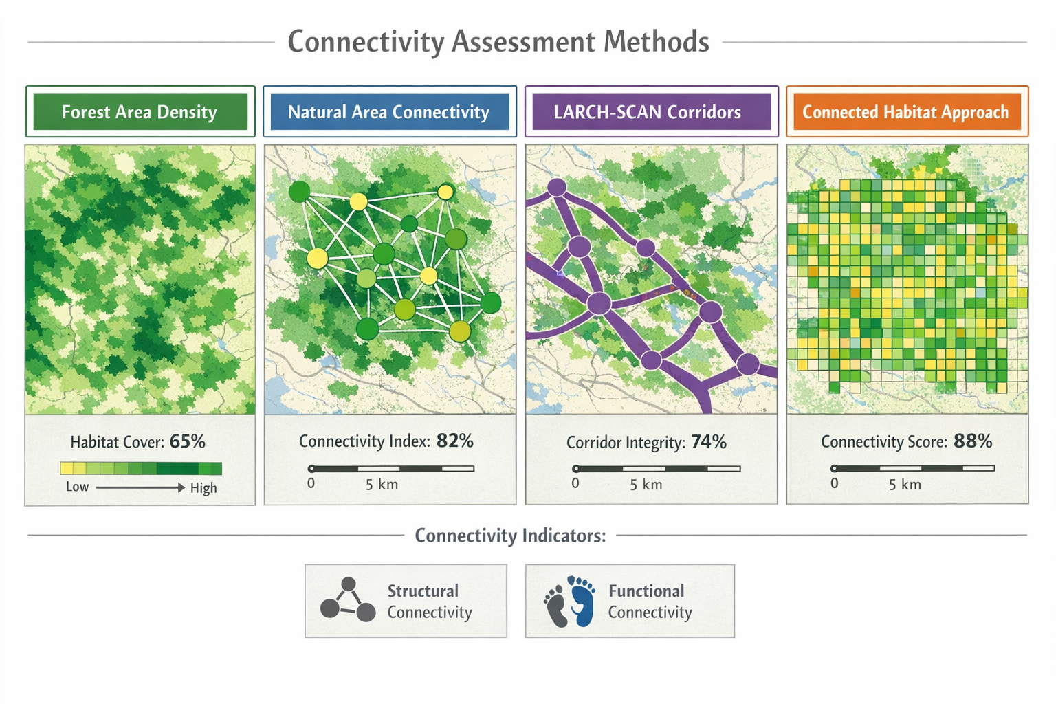
The February 2026 Biodiversa+ workshop harmonized multiple habitat connectivity indicators, each employing different approaches to assess how landscapes support species movement [2]. Understanding these methodologies enables surveyors to select appropriate tools for specific project contexts.
Structural Connectivity Indicators
Structural connectivity measures the physical arrangement of habitat patches without reference to species-specific movement behavior. These metrics provide foundational landscape analysis:
| Indicator | Description | Application |
|---|---|---|
| Forest Area Density (FAD) | Proportion of forest cover within defined radius around focal patches | Assessing woodland connectivity at regional scales |
| Natural Area Connectivity | Network analysis of habitat patches and potential linkages | Identifying critical connection points in fragmented landscapes |
| Patch Size Distribution | Statistical analysis of habitat fragment dimensions | Evaluating whether patches can support viable populations |
These structural metrics offer rapid, cost-effective initial assessment but cannot predict whether specific species will actually use potential corridors.
Functional Connectivity Models
Functional connectivity incorporates species-specific movement behavior, habitat preferences, and dispersal capabilities. These approaches provide more accurate predictions of actual species movement:
Connected Habitat Approach (CHA) evaluates landscape permeability for target species based on habitat quality, patch size, and distance thresholds. This method integrates species ecology into connectivity assessment, recognizing that a hedgerow might function as a corridor for small mammals but a barrier for ground beetles.
LARCH-SCAN modeling simulates species movement across landscapes by calculating least-cost paths between habitat patches. The model incorporates resistance values for different land cover types, generating probability surfaces that show likely movement routes [2].
Implementing Multi-Scale Connectivity Assessment
Effective connectivity surveys for Biodiversity Net Gain assessments require multi-scale analysis:
- Local scale (0-500m): Immediate project site connections to adjacent habitats
- Landscape scale (500m-5km): Regional corridor networks and stepping-stone habitats
- Bioregional scale (5-50km): Population-level connectivity supporting genetic exchange
The BiodivConnect research initiative emphasizes transposability of restoration actions across local, regional, and cross-border levels, recognizing that connectivity solutions must function at multiple spatial scales [1].
Field Survey Protocols for Mapping Species Movement
Translating connectivity theory into practical survey methodology requires structured field protocols that capture evidence of actual species movement across fragmented landscapes.
Pre-Survey Desktop Assessment
Before conducting field surveys, desktop analysis establishes the connectivity baseline:
- Habitat mapping using aerial imagery, LiDAR, and satellite data to identify potential corridors
- Historical connectivity analysis comparing current landscape structure with historical maps
- Species distribution modeling predicting likely movement routes based on known habitat associations
- Barrier identification mapping roads, waterways, urban areas, and other impediments to movement
This desktop phase informs strategic placement of field survey effort and identifies priority connectivity features requiring ground-truthing.
Technology-Enhanced Field Survey Methods
Emerging technologies identified in the 2026 horizon scan enable more comprehensive connectivity documentation [3]:
Tiny Machine Learning (TinyML) devices deploy AI-powered species detection in remote locations without internet connectivity. These solar-powered sensors continuously monitor wildlife corridors, documenting species use patterns across seasons and years. For developers conducting biodiversity impact assessments, TinyML provides robust baseline data on corridor functionality.
Camera trap networks positioned along potential corridors capture photographic evidence of species movement. Strategic placement at corridor pinch points, under hedgerows, and along woodland edges documents which species actively use connectivity features.
GPS tracking studies on target species provide direct evidence of movement patterns, home range sizes, and corridor utilization. While resource-intensive, tracking studies validate connectivity models and inform corridor design specifications.
Evidence-Based Corridor Assessment
Field surveys should document specific connectivity attributes:
✅ Corridor dimensions: Width, length, and continuity of linear habitat features
✅ Habitat quality: Vegetation structure, cover density, and food resource availability within corridors
✅ Barrier effects: Roads, fencing, drainage channels that impede movement
✅ Usage evidence: Tracks, scat, feeding signs, and direct observations indicating species presence
✅ Seasonal variation: How corridor functionality changes with vegetation phenology and weather
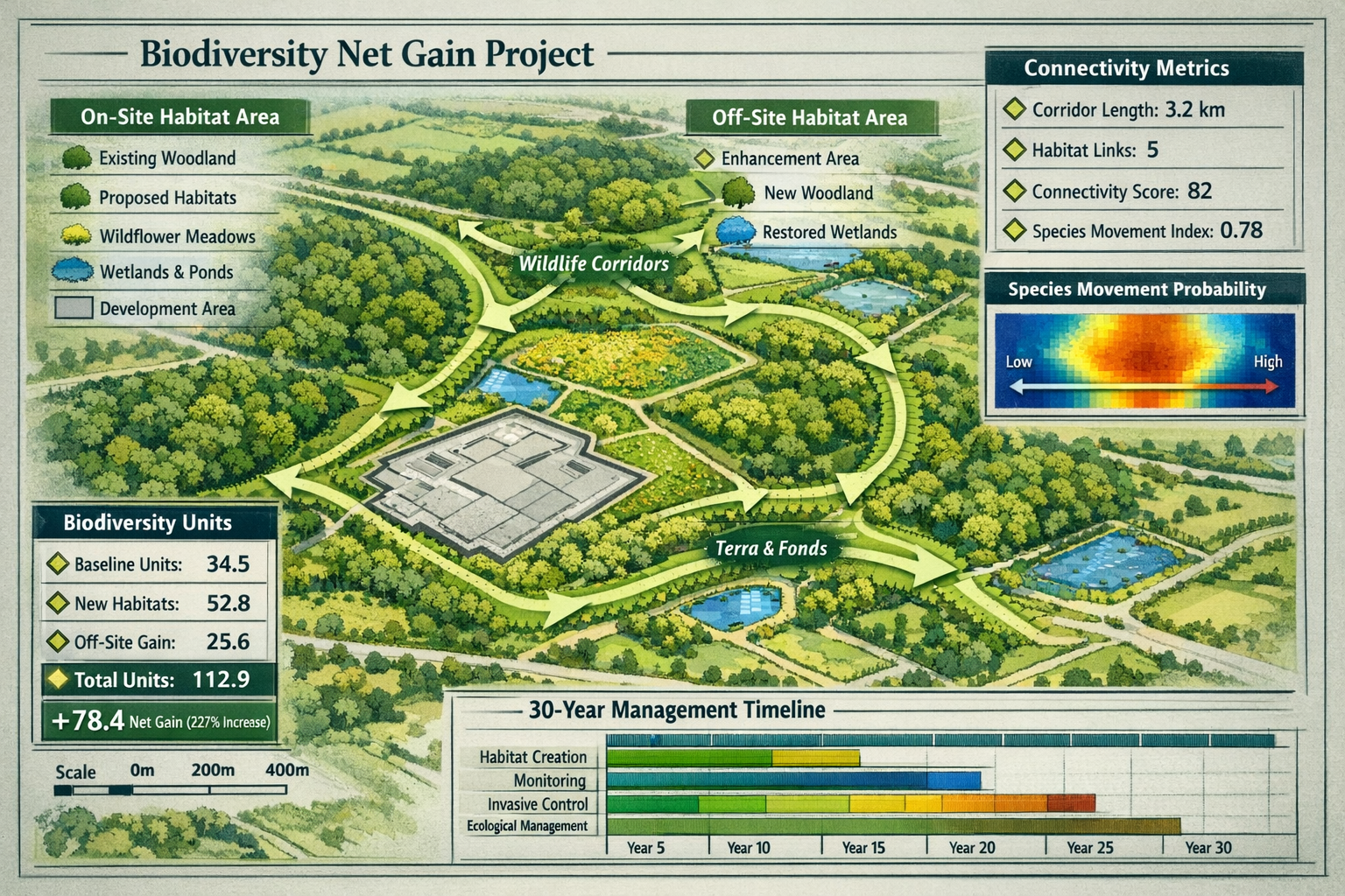
This evidence base supports achieving Biodiversity Net Gain without risk by demonstrating that proposed connectivity enhancements will deliver measurable ecological outcomes.
Integrating Connectivity Mapping into Ecosystem Connectivity in Biodiversity Surveys: Mapping Species Movement Across Fragmented Habitats for 2026 Net Gain Projects
The ultimate value of connectivity surveys lies in their integration into net gain project design, ensuring that habitat creation and enhancement contribute to functional ecological networks.
Strategic Corridor Placement in Net Gain Design
When deciding between off-site or on-site delivery of biodiversity units, connectivity considerations should guide spatial planning:
On-site connectivity enhancement focuses on creating or restoring corridors that connect project sites to surrounding habitats. A residential development might incorporate hedgerow networks linking retained woodland to off-site nature reserves, or create wetland stepping-stones connecting isolated ponds.
Off-site corridor creation addresses landscape-level connectivity gaps identified through regional assessment. Strategic land banking for BNG should prioritize sites that restore critical connectivity bottlenecks rather than simply maximizing biodiversity unit generation.
Connectivity Metrics in Biodiversity Net Gain Calculations
Current biodiversity metric calculations primarily assess habitat area and condition within project boundaries. Integrating connectivity metrics requires:
- Connectivity multipliers that increase biodiversity unit value for habitats that enhance landscape-level connectivity
- Corridor condition assessments evaluating width, continuity, and habitat quality of linear features
- Network analysis quantifying how project interventions improve regional connectivity indices
The international research community is actively developing these enhanced metrics through initiatives like BiodivConnect, which addresses defining restoration objectives and measuring success across ecosystem types [1].
Long-Term Connectivity Monitoring
Demonstrating connectivity improvements requires monitoring protocols that extend beyond typical construction phase surveys. The BiodivConnect research framework emphasizes long-term sustainability of restoration efforts [1], recognizing that connectivity benefits may take years or decades to fully materialize.
Monitoring protocols should include:
- Baseline documentation of pre-development connectivity conditions
- Construction phase monitoring ensuring corridor features are implemented as designed
- Establishment monitoring (Years 1-5) tracking habitat development and early species colonization
- Functional monitoring (Years 5-30) documenting sustained species use and population connectivity
For small development projects, proportionate monitoring might focus on simple indicators like hedgerow bird surveys or small mammal trapping, while major infrastructure projects warrant comprehensive tracking studies and population genetic analysis.
Policy Context and International Frameworks for 2026
The emphasis on ecosystem connectivity in biodiversity surveys reflects converging international policy commitments that shape UK net gain implementation.
Kunming-Montreal Global Biodiversity Framework
The global biodiversity framework prioritizes ecological connectivity as essential for ecosystem resilience and species adaptation to climate change. The March 2026 high-level conference on protecting migratory species emphasized connectivity protection for vital migratory corridors and networks [5], directly influencing how national governments implement biodiversity policies.
European Research Initiatives
The Biodiversa+ BiodivConnect program supports innovative research on ecosystem functioning, integrity, and connectivity across all ecosystem types and global regions [1]. With submission deadlines in April 2026, this research initiative will generate new methodologies and evidence bases that inform practical connectivity survey protocols.
The Deutsche Forschungsgemeinschaft (DFG) partnership in Biodiversa+ joint calls supports holistic and integrated approaches covering all global regions and habitat types [4], ensuring that connectivity research addresses diverse ecological contexts relevant to UK practitioners.
UK Implementation Considerations
For architects solving Biodiversity Net Gain challenges and planners navigating BNG requirements, connectivity considerations increasingly influence planning decisions. Local planning authorities are beginning to request connectivity assessments for major developments, recognizing that isolated habitat creation cannot deliver landscape-scale conservation outcomes.
Emerging Challenges and Future Directions
The 2026 global horizon scan identifies several emerging issues that will shape connectivity survey methodologies in coming years [3]:
Climate-Driven Connectivity Needs
Soil moisture decline across terrestrial and freshwater ecosystems affects habitat connectivity and species dispersal routes [3]. Connectivity surveys must anticipate how changing moisture regimes will alter corridor functionality, potentially requiring wider buffers around watercourses or enhanced irrigation for planted corridors.
Ocean darkening with declining light penetration affects marine productivity and coastal ecosystem connectivity [3]. For coastal developments, connectivity assessments should consider how changing marine conditions influence terrestrial-marine interface habitats.
Technological Advances in Survey Methods
Optical AI chips and advanced remote sensing enable more comprehensive connectivity mapping at reduced cost [3]. These technologies will make landscape-scale connectivity assessment feasible for small development projects that previously could not justify extensive survey effort.
Cross-Border Connectivity Planning
The International Conference on Ecosystem Connectivity and Restoration scheduled for June 2026 in Stuttgart [7] will advance frameworks for cross-border connectivity planning. For UK projects near international boundaries or affecting migratory species with international ranges, these frameworks will inform survey scope and methodology.
Practical Implementation for Developers and Surveyors
Translating connectivity science into deliverable survey products requires practical approaches that balance ecological rigor with project constraints.
Scoping Connectivity Surveys
When creating biodiversity plans for development projects, connectivity assessment scope should reflect:
- Project scale: Larger developments warrant more comprehensive landscape-level analysis
- Ecological context: Sites within or adjacent to important wildlife corridors require detailed connectivity assessment
- Target species: Presence of priority species with specific connectivity needs influences survey design
- Regulatory requirements: Local planning authority expectations for connectivity evidence
Cost-Effective Connectivity Assessment
Connectivity surveys need not require extensive budgets. Proportionate approaches include:
- Desktop modeling using freely available GIS data and open-source connectivity tools
- Targeted field validation focusing on key corridor features rather than comprehensive landscape coverage
- Opportunistic data collection integrating connectivity observations into standard habitat surveys
- Collaborative data sharing leveraging regional biodiversity records and existing tracking studies
Reporting Connectivity Findings
Connectivity survey reports should clearly communicate:
- Existing connectivity baseline documenting current landscape structure and species movement patterns
- Project impacts on connectivity identifying how development will affect existing corridors
- Mitigation hierarchy application showing avoidance, minimization, and compensation for connectivity impacts
- Enhancement opportunities proposing corridor creation or restoration that improves landscape-level connectivity
- Monitoring recommendations specifying how connectivity outcomes will be verified over time
Conclusion
Ecosystem connectivity represents the next frontier in biodiversity survey practice, moving beyond site-based habitat assessment toward landscape-level ecological network mapping. As Ecosystem Connectivity in Biodiversity Surveys: Mapping Species Movement Across Fragmented Habitats for 2026 Net Gain Projects becomes standard practice, developers and ecologists must adopt survey methodologies that capture the functional relationships between habitat patches that determine long-term species viability.
The convergence of international policy frameworks, emerging technologies, and advancing ecological science creates unprecedented opportunities to integrate connectivity planning into development projects. The BiodivConnect research initiative, 2026 horizon scan findings, and international conferences scheduled throughout 2026 will continue refining connectivity assessment methods and generating evidence bases that inform practical implementation.
Actionable Next Steps
For developers and project managers:
- Engage connectivity specialists early in project scoping to identify survey requirements and opportunities
- Request landscape-level analysis that extends beyond project boundaries to assess regional connectivity context
- Consider connectivity value when evaluating off-site biodiversity unit options or selling biodiversity units
For ecologists and surveyors:
- Develop expertise in connectivity modeling tools and functional connectivity assessment methods
- Integrate connectivity metrics into standard biodiversity survey protocols and reporting
- Collaborate with researchers participating in BiodivConnect and similar initiatives to apply cutting-edge methodologies
For planners and regulators:
- Establish connectivity policies that require landscape-level assessment for major developments
- Support strategic corridor planning at local authority level to guide individual project contributions
- Recognize connectivity value in biodiversity net gain calculations and planning decisions
The transition from isolated habitat assessment to integrated connectivity mapping represents a fundamental evolution in how biodiversity surveys support conservation outcomes. By embracing landscape-scale thinking and evidence-based corridor planning, the development sector can deliver net gain projects that contribute to functional ecological networks capable of sustaining biodiversity through decades of environmental change.
References
[1] 2026 Biodivconnect Restoring The Functionality Integrity And Connectivity Of Biodiversa Ecosystems – https://www.mio.osupytheas.fr/en/call_offer/2026-biodivconnect-restoring-the-functionality-integrity-and-connectivity-of-biodiversa-ecosystems/
[2] Connectivity Workshop Report – https://www.biodiversa.eu/2026/03/02/connectivity-workshop-report/
[3] Whats Next For Biodiversity Conservation Insights From The 2026 Horizon Scan – https://www.unep-wcmc.org/en/news/whats-next-for-biodiversity-conservation-insights-from-the-2026-horizon-scan
[4] Ifr 25 67 – https://www.dfg.de/en/news/news-topics/announcements-proposals/2025/ifr-25-67
[5] Global High Level Conference To Protect Migratory Species Begins – https://www.eureporter.co/nature/2026/03/25/global-high-level-conference-to-protect-migratory-species-begins/
[7] conferencealerts.co.in – https://conferencealerts.co.in/event/100666425
