
A new environmental threat is emerging from an unexpected source: the fiber-optic cables trailing behind modern drones. As biodiversity professionals increasingly deploy unmanned aerial vehicles for remote habitat surveys and wildlife monitoring in 2026, recent evidence from conflict zones has revealed a troubling pattern. Fibre Optic Drone Cables: Biodiversity Surveyor Checklists for Assessing Wildlife Entanglement Risks in 2026 represents a critical framework for ecological professionals to prevent similar environmental damage in conservation contexts.
The scale of this emerging threat became apparent through documented cases where drones deployed between 5-20 kilometers of fiber-optic cable per mission—with some spools extending up to 41 kilometers.[1] These lightweight yet incredibly strong cables create extensive debris networks that persist in the environment for more than 600 years, posing entanglement risks comparable to ghost fishing gear.[1] For biodiversity surveyors utilizing drone technology for habitat assessments, understanding and mitigating these risks has become an urgent priority.
Key Takeaways
- Fiber-optic drone cables pose significant entanglement risks to birds, bats, and ground-dwelling mammals, with documented cases of suffocation, trapped limbs, and behavioral disruption
- Cables persist in environments for 600+ years, creating long-term barriers to wildlife movement and habitat connectivity
- Biodiversity surveyors need comprehensive checklists to assess deployment sites, cable management protocols, and post-mission retrieval verification
- Risk assessment must consider species vulnerability, habitat type, migration corridors, and seasonal wildlife activity patterns
- Proactive protocols can prevent ecological damage while maintaining the benefits of drone-based biodiversity monitoring
Understanding the Wildlife Entanglement Threat from Drone Cables
The Scale and Persistence of Cable Debris
Fiber-optic cables used in drone operations present unique environmental challenges that distinguish them from traditional wireless systems. Unlike radio-controlled drones, fiber-optic variants trail physical cables that can extend for kilometers behind the aircraft. This technology offers advantages in electronic warfare resistance and signal reliability, but creates substantial environmental liabilities when cables are not properly retrieved.[1]
The environmental persistence of these materials represents perhaps the most concerning aspect. Composed of glass fibers surrounded by plastic cladding and protective sheaths, fiber-optic cables can remain intact in natural environments for more than six centuries.[1] This longevity means that even a single improperly managed drone survey could create entanglement hazards affecting multiple generations of wildlife.
Research from affected areas has documented cables creating "fences in the sky, on the ground and in waterways," effectively fragmenting habitats and restricting wildlife movement.[1] For biodiversity surveyors working to achieve biodiversity net gain, understanding these impacts is essential for responsible technology deployment.
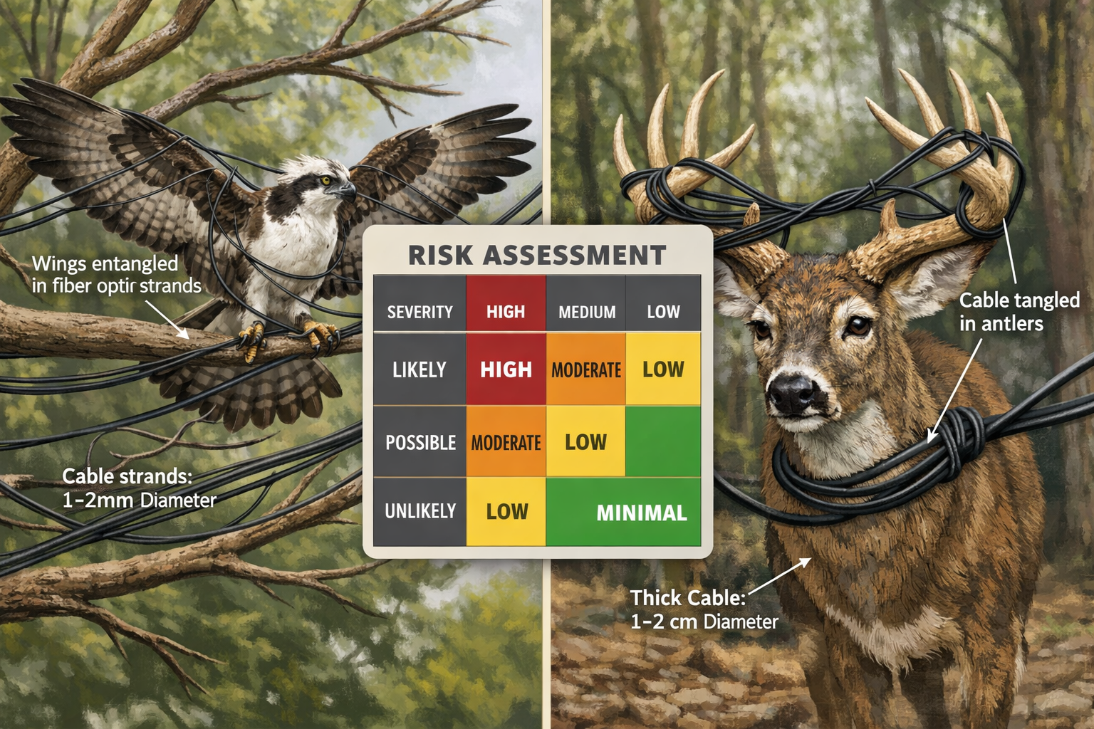
Documented Wildlife Impacts
As of March 2026, wildlife experts have documented several categories of entanglement incidents:
Avian Species 🦅
- Birds becoming trapped in cable webs spanning tree canopies
- Suffocation from cable entanglement around wings and bodies
- Nesting material incorporation leading to chick entanglement
- Collision injuries with near-invisible cable strands
Mammals 🦌
- Deer with cables woven into antlers during growth periods
- Ground-dwelling species caught while moving through undergrowth
- Disrupted movement corridors affecting foraging and breeding behavior
Bats 🦇
- Echolocation interference from cable networks
- Wing membrane entanglement during flight
- Roost access obstruction in affected woodland areas
Charlie Russell, a researcher at the University of East Anglia studying war impacts on migratory birds, warned that fiber optic cables "cover large areas of wooded and edge habitats, forming dangerous webs across trees and clearings that will pose a significant risk of entanglement and death to many species, including threatened birds and bats, for years to come."[1]
These documented cases underscore the importance of developing Fibre Optic Drone Cables: Biodiversity Surveyor Checklists for Assessing Wildlife Entanglement Risks in 2026 that address both immediate deployment safety and long-term environmental stewardship.
Chemical and Microplastic Concerns
Beyond physical entanglement, fiber-optic cables present additional environmental hazards through degradation processes. Cables exposed to UV radiation, temperature fluctuations, physical abrasion, and environmental weathering break down over time, releasing microplastics into soil and water systems.[3]
Chemical contamination risks include:
- PFAS compounds (per- and polyfluoroalkyl substances) used in cable cladding that persist indefinitely in environments[7]
- Microplastic particles that disrupt soil microbial ecosystems and reduce agricultural productivity
- Polymer degradation products released through thermal and photochemical breakdown
Agricultural research has linked microplastics in soil to reduced crop yields and disrupted microbial ecosystems essential for nutrient cycling.[3] For biodiversity surveyors conducting biodiversity impact assessments, these secondary impacts must factor into risk evaluation protocols.
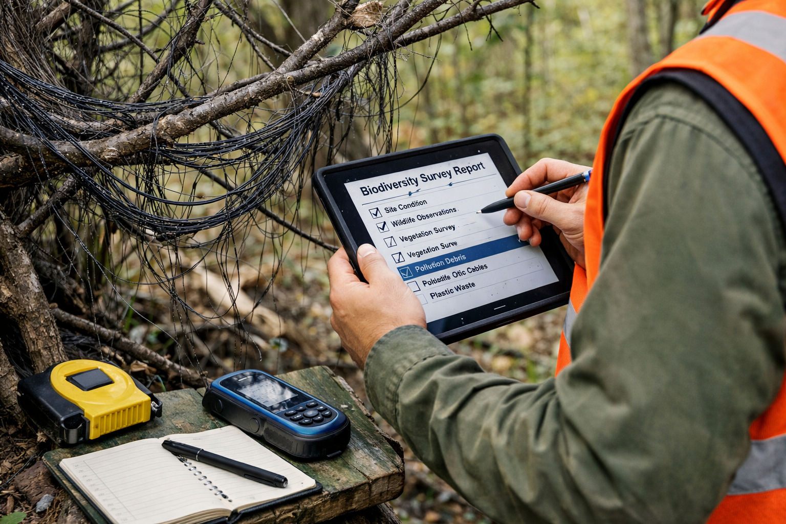
Developing Comprehensive Pre-Deployment Assessment Checklists
Site Evaluation Criteria
Before deploying fiber-optic drones for biodiversity surveys, professionals must conduct thorough site assessments using standardized checklists. The following framework provides essential evaluation criteria:
Habitat Type Assessment 🌳
| Habitat Category | Entanglement Risk Level | Key Considerations |
|---|---|---|
| Dense Woodland | High | Complex canopy structure, multiple vertical layers, high bird/bat activity |
| Woodland Edge | Very High | Maximum species diversity, migration corridors, nesting habitat |
| Open Grassland | Moderate | Ground-dwelling species risk, raptor hunting areas |
| Wetlands | High | Waterfowl congregation, amphibian breeding sites, vegetation entanglement |
| Scrubland | High | Tangled vegetation amplifies cable retention, small mammal habitat |
Species Vulnerability Factors
Surveyors must identify protected and vulnerable species present in survey areas:
- Red-listed species with legal protections requiring enhanced safeguards
- Migratory birds during peak passage periods (spring/autumn)
- Breeding season activity when territorial behavior increases flight frequency
- Bat populations in roosting, foraging, and commuting areas
- Large mammals with antlers, horns, or complex appendages
For projects requiring biodiversity net gain planning, these assessments align with broader ecological impact evaluation frameworks already familiar to surveyors.
Temporal Risk Assessment
Wildlife activity patterns vary dramatically across temporal scales, requiring surveyors to time drone deployments strategically:
Seasonal Considerations 📅
- Spring (March-May): Peak bird nesting, amphibian breeding, increased territorial flights
- Summer (June-August): Fledgling birds learning flight, bat maternity colonies active
- Autumn (September-November): Migration corridors heavily utilized, pre-hibernation foraging
- Winter (December-February): Reduced activity but concentrated resource use, roosting aggregations
Daily Activity Patterns ⏰
- Dawn/Dusk: Maximum bat activity, crepuscular species foraging
- Midday: Raptor thermal soaring, reduced small bird activity
- Night: Nocturnal species vulnerable to invisible cable hazards
Integrating temporal risk assessment into Fibre Optic Drone Cables: Biodiversity Surveyor Checklists for Assessing Wildlife Entanglement Risks in 2026 ensures deployments occur during minimum-risk windows while maintaining survey effectiveness.
Cable Management Protocol Requirements
Effective cable management represents the primary mitigation strategy for preventing wildlife entanglement. Surveyors should implement the following protocols:
Pre-Flight Planning ✅
- Calculate exact cable length requirements with 10% safety margin
- Map flight paths avoiding sensitive habitats and known wildlife corridors
- Establish maximum deployment distances based on retrieval capability
- Designate cable recovery personnel and equipment before launch
During Operations
- Maintain continuous visual contact with trailing cable
- Monitor cable tension and drag indicators
- Document cable path using GPS tracking for retrieval reference
- Abort missions if cable snags or unexpected resistance occurs
Post-Mission Retrieval
- Conduct systematic cable recovery immediately following landing
- Verify 100% cable retrieval through spool measurement comparison
- Inspect flight path for residual cable fragments or breakage
- Document any cable loss incidents with location coordinates
These protocols align with broader biodiversity net gain strategies that prioritize avoiding ecological harm as the first tier of the mitigation hierarchy.
Implementing Field Assessment Checklists for Wildlife Risk
The Comprehensive Surveyor Checklist Framework
Biodiversity professionals require practical, field-ready checklists that translate risk assessment principles into actionable protocols. The following framework provides a comprehensive approach to Fibre Optic Drone Cables: Biodiversity Surveyor Checklists for Assessing Wildlife Entanglement Risks in 2026:
Phase 1: Pre-Survey Desktop Assessment
Ecological Baseline Review 📊
- Review existing ecological surveys and protected species records
- Consult local biodiversity databases and conservation organizations
- Identify statutory designated sites within 2km radius
- Map known wildlife corridors and migration routes
- Review seasonal restrictions and protected species licensing requirements
Technology Specification Review
- Confirm cable length, diameter, and material composition
- Verify cable tensile strength and breakage risk factors
- Review manufacturer retrieval success rates and failure modes
- Assess cable visibility characteristics (color, reflectivity)
- Evaluate alternative wireless drone options for high-risk sites
Phase 2: Site Reconnaissance
Physical Habitat Assessment 🔍
- Document vegetation structure and density
- Identify cable snagging hazards (dead wood, thorny vegetation, water features)
- Assess ground conditions affecting cable drag and retrieval
- Map obstacles that could cause cable breakage or entanglement
- Photograph reference points for cable path documentation
Wildlife Activity Indicators
- Conduct preliminary wildlife surveys during proposed flight times
- Document nesting sites, roosts, burrows, and dens within 500m
- Identify feeding areas, water sources, and congregation points
- Record evidence of wildlife movement (tracks, trails, flight paths)
- Note any observed wildlife behavior changes during test flights
Phase 3: Risk Scoring Matrix
Surveyors should apply quantitative risk scoring to determine deployment appropriateness:
Risk Factor Calculation
| Factor | Low Risk (1 point) | Moderate Risk (2 points) | High Risk (3 points) |
|---|---|---|---|
| Habitat Complexity | Open, simple structure | Mixed vegetation | Dense, multi-layered |
| Protected Species | None present | Common species | Red-listed species |
| Seasonal Timing | Low activity period | Moderate activity | Breeding/migration peak |
| Cable Length | <2km | 2-5km | >5km |
| Retrieval Conditions | Excellent visibility/access | Moderate challenges | Difficult terrain/vegetation |
Risk Score Interpretation:
- 5-8 points: Proceed with standard protocols
- 9-12 points: Enhanced mitigation required, consider alternatives
- 13-15 points: High risk—recommend wireless alternatives or survey postponement
This scoring system provides objective decision-making frameworks that complement professional judgment while ensuring consistent risk evaluation across survey teams.
Alternative Technology Decision Trees
When risk assessments indicate unacceptable entanglement hazards, surveyors should evaluate alternative approaches:
Technology Alternatives 🚁
- Wireless Drone Systems: Standard radio-controlled UAVs for lower-risk applications
- Satellite-Linked Drones: Long-range capability without physical tethers
- Ground-Based Survey Methods: Traditional transect surveys or camera traps
- Manned Aircraft: Helicopter or fixed-wing surveys for large-area assessments
- Hybrid Approaches: Combining multiple methods to achieve survey objectives
The decision to use fiber-optic drones should balance operational advantages against ecological risks, with biodiversity protection taking precedence in marginal cases. This approach aligns with the precautionary principle embedded in biodiversity net gain frameworks.
Post-Deployment Monitoring and Incident Response
Even with comprehensive pre-deployment assessment, surveyors must maintain vigilance during and after operations:
Immediate Post-Flight Verification ✓
- Measure retrieved cable length against deployment records
- Inspect cable condition for damage, fraying, or weak points
- Document any retrieval difficulties or partial cable loss
- Photograph cable storage and disposal methods
- Complete incident reports for any environmental contacts
Follow-Up Monitoring Protocols
- Return to survey sites within 24-48 hours to verify no residual cable
- Conduct targeted wildlife casualty searches along flight paths
- Monitor local wildlife behavior for displacement or avoidance patterns
- Document any entanglement incidents with photographic evidence
- Report incidents to relevant conservation authorities
Incident Response Procedures 🚨
If cable loss or wildlife entanglement occurs:
- Immediate Action: Cease further fiber-optic drone operations in affected area
- Documentation: Photograph incident, record GPS coordinates, note weather/environmental conditions
- Retrieval Attempt: Deploy ground teams with appropriate safety equipment to recover lost cable
- Wildlife Rescue: Contact licensed wildlife rehabilitators if animals are entangled
- Regulatory Notification: Inform relevant environmental authorities as required by jurisdiction
- Protocol Review: Conduct root cause analysis and update procedures
These response protocols ensure that Fibre Optic Drone Cables: Biodiversity Surveyor Checklists for Assessing Wildlife Entanglement Risks in 2026 include not only prevention but also remediation strategies.
Best Practices for Responsible Fiber-Optic Drone Deployment
Industry Standards and Regulatory Compliance
As awareness of fiber-optic cable environmental risks grows in 2026, biodiversity surveyors should anticipate evolving regulatory frameworks. Proactive adoption of best practices positions organizations ahead of compliance requirements:
Emerging Regulatory Considerations 📋
- Environmental Impact Declarations: Documenting cable management protocols in survey planning documents
- Protected Species Licensing: Obtaining additional permissions for fiber-optic drone use near sensitive species
- Habitat Management Plans: Integrating cable retrieval verification into broader site management
- Monitoring Requirements: Demonstrating post-deployment habitat condition assessments
Organizations conducting biodiversity net gain assessments should integrate fiber-optic drone risk evaluation into existing environmental management systems.
Training and Competency Requirements
Effective implementation of wildlife entanglement risk protocols requires specialized training for survey teams:
Essential Competencies 🎓
- Ecological Knowledge: Understanding habitat types, species behavior, and seasonal patterns
- Risk Assessment Skills: Applying checklist frameworks and scoring matrices
- Cable Management Techniques: Proper deployment, monitoring, and retrieval procedures
- Incident Response: Wildlife rescue protocols and regulatory reporting requirements
- Alternative Methods: Competency in wireless drone and traditional survey techniques
Professional development programs should incorporate these competencies into biodiversity surveyor certification pathways, ensuring consistent application of Fibre Optic Drone Cables: Biodiversity Surveyor Checklists for Assessing Wildlife Entanglement Risks in 2026 across the industry.
Technology Innovation and Safer Alternatives
The biodiversity survey sector should actively support development of safer fiber-optic drone technologies:
Innovation Priorities 💡
- Biodegradable Cable Materials: Developing cables that degrade safely within 1-2 years if lost
- High-Visibility Cable Designs: Incorporating colors and patterns detectable by wildlife
- Automated Retrieval Systems: Mechanical spooling mechanisms ensuring 100% cable recovery
- Break-Away Connections: Weak points that separate cables before wildlife entanglement occurs
- Real-Time Monitoring: Sensors detecting cable snags or abnormal resistance during flight
Surveyors should engage with drone manufacturers to communicate ecological requirements, driving market development toward environmentally responsible technologies.
Case Study: Implementing Risk Assessment in Woodland Surveys
Scenario: A biodiversity survey team planned to use fiber-optic drones for canopy-level habitat assessment in ancient woodland supporting protected bat species.
Risk Assessment Outcome:
- Habitat complexity: High risk (dense, multi-layered canopy)
- Protected species: High risk (multiple bat species, breeding season)
- Cable length required: Moderate risk (3.5km)
- Retrieval conditions: High risk (limited ground access, dense understory)
- Total Risk Score: 13/15 (High risk—alternatives recommended)
Resolution: Team substituted wireless drone with thermal imaging capability for bat roost identification, supplemented by traditional ground-based acoustic monitoring. Survey objectives achieved without cable entanglement risk.
This example demonstrates how Fibre Optic Drone Cables: Biodiversity Surveyor Checklists for Assessing Wildlife Entanglement Risks in 2026 enable informed decision-making that protects both wildlife and survey quality.
Long-Term Environmental Stewardship and Future Outlook
Global Expansion of Fiber-Optic Drone Technology
The environmental challenges documented in 2026 may represent only the beginning of a broader trend. Reports indicate that multiple nations are testing fiber-optic drone technology, suggesting the contamination problem could expand beyond current conflict zones to civilian applications worldwide.[1]
For biodiversity professionals, this expansion creates both challenges and opportunities:
Challenges ⚠️
- Increased cable debris in natural environments
- Wildlife populations with no evolutionary adaptation to cable hazards
- Cumulative impacts from multiple survey organizations using similar technology
- Regulatory lag behind technological adoption
Opportunities ✨
- Establishing industry-leading environmental standards
- Demonstrating responsible technology stewardship
- Influencing regulatory frameworks through proactive best practices
- Developing expertise in emerging ecological risk assessment
Organizations positioning themselves as environmental leaders in drone technology deployment will gain competitive advantages as regulatory scrutiny intensifies.
Research Gaps and Knowledge Needs
Despite growing awareness of fiber-optic cable environmental risks, significant research gaps remain. Biodiversity surveyors can contribute valuable data through systematic monitoring:
Priority Research Questions 🔬
- Species-Specific Vulnerability: Which taxa face greatest entanglement risks under different habitat conditions?
- Behavioral Responses: How do wildlife populations adapt to or avoid cable-contaminated habitats?
- Degradation Timelines: What environmental factors accelerate or slow cable breakdown?
- Microplastic Impacts: How do fiber-optic cable microplastics affect soil ecology and food webs?
- Mitigation Effectiveness: Which cable management protocols most effectively prevent wildlife incidents?
Surveyors implementing comprehensive monitoring protocols contribute to the evidence base supporting biodiversity conservation objectives while advancing scientific understanding of emerging threats.
Integration with Biodiversity Net Gain Frameworks
The principles underlying Fibre Optic Drone Cables: Biodiversity Surveyor Checklists for Assessing Wildlife Entanglement Risks in 2026 align closely with biodiversity net gain mitigation hierarchies:
Mitigation Hierarchy Application 🎯
- Avoid: Use alternative survey methods in high-risk habitats
- Minimize: Implement comprehensive cable management protocols
- Restore: Conduct immediate cable retrieval and habitat verification
- Offset: Support wildlife rehabilitation for any entanglement incidents
This framework ensures that drone-based survey activities contribute positively to biodiversity net gain objectives rather than creating unaccounted ecological debts.
Professional Responsibility and Ethical Considerations
Biodiversity surveyors occupy a unique position of trust as environmental stewards. The adoption of fiber-optic drone technology without adequate risk assessment would represent a fundamental breach of professional ethics:
Ethical Principles 🤝
- Do No Harm: Prioritizing wildlife protection over operational convenience
- Precautionary Approach: Avoiding technologies with uncertain ecological impacts
- Transparency: Documenting and reporting cable management protocols and incidents
- Continuous Improvement: Updating practices based on emerging evidence
- Knowledge Sharing: Contributing to industry-wide learning and standard development
These principles should guide organizational policies and individual decision-making as fiber-optic drone technology becomes more prevalent in biodiversity survey applications.
Conclusion
The emergence of fiber-optic drone cables as a significant wildlife entanglement threat in 2026 presents biodiversity surveyors with both challenges and opportunities for environmental leadership. Evidence from conflict zones has demonstrated that these cables create persistent hazards—lasting more than 600 years in natural environments—that threaten birds, bats, mammals, and ecosystem functioning through physical entanglement, habitat fragmentation, and chemical contamination.[1][7]
Fibre Optic Drone Cables: Biodiversity Surveyor Checklists for Assessing Wildlife Entanglement Risks in 2026 provides a comprehensive framework for responsible technology deployment that protects wildlife while maintaining the operational advantages of drone-based surveys. By implementing systematic risk assessment protocols, surveyors can identify high-risk scenarios where alternative methods are appropriate, and apply enhanced mitigation measures when fiber-optic drones represent the best survey option.
Actionable Next Steps
Biodiversity professionals should take the following immediate actions:
- Audit Current Practices: Review existing drone deployment protocols for wildlife risk considerations
- Implement Checklists: Adopt comprehensive pre-deployment assessment frameworks outlined in this article
- Train Teams: Ensure all personnel understand cable management protocols and incident response procedures
- Engage Manufacturers: Communicate ecological requirements to drone technology suppliers
- Monitor and Report: Establish systematic post-deployment monitoring and contribute to industry knowledge
- Update Policies: Integrate fiber-optic cable risk assessment into organizational environmental management systems
- Share Learning: Participate in professional networks developing industry standards
As fiber-optic drone technology expands globally, the biodiversity survey sector has an opportunity to demonstrate environmental stewardship that protects wildlife while advancing conservation science. The frameworks presented here provide practical tools for achieving this balance, ensuring that technological innovation serves rather than undermines ecological objectives.
For organizations seeking to align drone survey practices with biodiversity net gain requirements and broader conservation goals, comprehensive wildlife entanglement risk assessment represents not just regulatory compliance but fundamental professional responsibility. By adopting proactive protocols now, surveyors position themselves as industry leaders while protecting the ecosystems they are entrusted to study and conserve.
References
[1] Plastic Pollution From Fibre Optic Drones May Threaten Wildlife For Years – https://ceobs.org/plastic-pollution-from-fibre-optic-drones-may-threaten-wildlife-for-years/
[2] Death From Above How Drones Are Reshaping Wildlife In Ukraine – https://original.antiwar.com/christopher_bancroft/2026/03/30/death-from-above-how-drones-are-reshaping-wildlife-in-ukraine/
[3] Fiber Optic Drone Ukraine Battlefields – https://dronexl.co/2026/02/10/fiber-optic-drone-ukraine-battlefields/
[4] Fiber Optic Drones In Ukraine Military Advantage And Emerging Environmental Risks – https://uwecworkgroup.info/fiber-optic-drones-in-ukraine-military-advantage-and-emerging-environmental-risks/
[5] Tangled Battlefields Addressing The Environmental Concerns Of Fiber Optic Drones In Ukraine – https://www.napforum.org/policy-briefs/tangled-battlefields-addressing-the-environmental-concerns-of-fiber-optic-drones-in-ukraine
[6] Fiber Optic Web How The Use Of Drones On The Frontlines Impacts The Environment – https://uwecworkgroup.info/fiber-optic-web-how-the-use-of-drones-on-the-frontlines-impacts-the-environment/
[7] Drone Debris Warfare Ukraine Toxic Waste – https://euperspectives.eu/2026/03/drone-debris-warfare-ukraine-toxic-waste/
